On State Highway 16, 0.1 miles north of Charles Spencer Road (County Route 1534), on the right when traveling north.
Grayson County, Virginia Formed in 1792 from Wythe. Named for William Grayson, one of the first two United States Senators from Virginia. Headwaters of
New River are in this county.
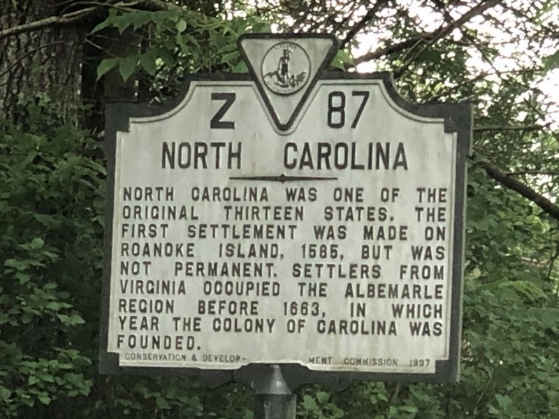
North Carolina North Carolina was one of the original . . . — — Map (db m228775) HM
On State Highway 91, 1.6 miles south of Jeb Stuart Highway (U.S. 58), on the right when traveling south.
Washington County, Virginia Formed in 1776 from Fincastle, and named for George Washington. This county was the first locality named for him. General William Campbell, hero of King's Mountain, lived in this county. Emory and Henry College is in . . . — — Map (db m228773) HM
On Alt. US 13 Front Street at Courthouse Ave., on the right when traveling north on Alt. US 13 Front Street.
Here stood the birthplace of Henry Alexander Wise (1806-1876), Governor of Virginia (1856-1860) and general in the Confederate States Army. A talented orator and debator in an age of great orators, Wise was elected to six terms in Congress. He . . . — — Map (db m7823) HM
On Courthouse Ave. (County Route 764) 0.1 miles north of Front Street (Alternate U.S. 13), on the right when traveling west.
Built in 1783 in one corner of the jailyard to serve as a residence for the jailer, the building served in this capacity for 41 years. Iron bars, oak batten doors and locks were added in 1842 when it was converted into a prison for debtors in . . . — — Map (db m162818) HM
On Alt. US 13 Front Street at T. C. Walker Drive, on the right when traveling north on Alt. US 13 Front Street.
The first high school for blacks in Accomack County was dedicated on this site in 1932. It was named in honor of Mary Nottingham Smith (1892-1951), a black educator who dedicated her life to educating all young people. In 1956, the school was . . . — — Map (db m7822) HM
On Lankford Highway (U.S. 13) at Savagetown Road (Virginia Route 603), on the right when traveling south on Lankford Highway.
The Occohannock Indians, one of the important Virginia Indian groups on the Eastern Shore, were composed of several tribes including the Onancock, Machipongo, Metomkin, Chincoteague, Kegotank, Pungoteague, Chesconessex, and Nandua. Capt. John Smith . . . — — Map (db m71855) HM
On U.S. 13 at County Line Road, on the right when traveling north on U.S. 13.
Five miles west is "Hedra Cottage", site of the home of Colonel Edmund Scarborough (Scarburgh), surveyor general of the colony. Beyond, at the end of Scarborough's Neck, was the village of the Occahannock Indians, the seat of Debedeavon, the . . . — — Map (db m7608) HM
On Adams Crossing Road at US 13, on the right when traveling east on Adams Crossing Road.
This first play recorded in the United States was presented August 27, 1665. The Accomack County Court at Pungoteague heard charges against three men “for acting a play,” ordered inspection of costumes and script, but found the men . . . — — Map (db m7613) HM
On Adams Crossing Road at US 13, on the right when traveling east on Adams Crossing Road.
Two miles east, on Route 600, meets what is possibly the nation's oldest continuous Sunday School. Begun by William Elliott in his home in 1785, it was moved in 1816 to Burton's Chapel and in 1870 to the present church. — — Map (db m7615) HM
On US 13 at W. Main Street, on the left when traveling north on US 13.
Two miles west is Onancock, founded in 1680. A courthouse was then built and used for a few years. Militia barracks were there in the Revolution. From Onancock, Colonel John Cropper went to the aid of Commodore Whaley in the last naval action of the . . . — — Map (db m7673) HM
On County Line Road at County Line Road, on the right when traveling north on County Line Road.
Accomack County. Area 502 Square Miles. The Eastern Shore was first known as the Kingdom of Accomack, for an Indian tribe. Accomac was one of the original shires formed in 1634. The name was changed to Northampton in 1643. In . . . — — Map (db m7609) HM
On Main Ridge Road near Thomas Road, on the left when traveling north.
In April 1814, during the war of 1812, British
forces commanded by Adm. Sir George Cockburn
established Fort Albion on the southern tip of
Tangier Island. The fort, which included barracks
a hospital, a church, parade grounds, and . . . — — Map (db m97720) HM
The island was visited in 1608 by Captain John Smith, who gave it the name. A part was patented by Ambrose White in 1670. It was settled in 1686 by John Crockett and his sons’ families. In 1814, it was the headquarters of a British fleet ravaging . . . — — Map (db m46705) HM
On Main Ridge Road at Pondarosa Road and Twin John Road, on the right when traveling south on Main Ridge Road.
Joshua Thomas (1776–1853) became a skilled waterman
from the in his youth and ferried clergymen
from the mainland to the islands of the
Chesapeake Bay.
He converted to Methodism
about 1807, was licensed as an exhorter (or lay preacher) . . . — — Map (db m97688) HM
On US 13 north of Saxis Road, on the left when traveling north.
Five miles west was the home of the Rev. Francis Makemie, founder of Presbyterianism in the United States. About 1684, Makemie established in Maryland the first Presbyterian Church. Later he moved to Accomac and married. He died here in 1708. — — Map (db m7830) HM
On Chincoteague Road (Route 175) 3.4 miles east of Fleming Road (Virginia Route 679), on the right when traveling east.
The Wallops Island Flight Facility was established in 1945 by the National Advisory Committee for Aeronautics and is one of the oldest launch sites in the world. This facility was built to conduct aeronautical research using rocket-propelled . . . — — Map (db m63666) HM
On Rockfish Gap Turnpike (U.S. 250) east of Afton Mountain Road (Virginia Route 6), on the right when traveling west.
Albemarle County. Albemarle County was formed in 1744 from Goochland County and named for William Anne Keppel, the second Earl of Albemarle, titular governor of Virginia from 1737 to 1754. A portion of Louisa County was later added to . . . — — Map (db m4030) HM
On Seminole Trail (U.S. 29) north of Frays Mill Road / Burnley Station Road, in the median. Reported missing.
Albemarle County. Albemarle County was formed in 1744 from Goochland County and named for William Anne Keppel, the second Earl of Albemarle, titular governor of Virginia from 1747 to 1754. A portion of Louisa County was later added to . . . — — Map (db m21585) HM
On Stony Point Road (State Highway 20) at Turkey Sag Road (County Road 640), on the right when traveling west on Stony Point Road.
Extending from the Orange County line on the north to the outskirts of Charlottesville with the Southwest Mountains forming its spine, this historic district encompasses more than 31,000 acres and contains some of the Piedmont’s most pristine and . . . — — Map (db m40775) HM
On Plank Road (County Route 692) just west of Miller School Road (County Route 635), on the right when traveling west.
The Staunton and James River Turnpike ran
through here at Batesville and stretched for
43½ miles from Staunton to Scottsville.
Construction began in 1826 and was completed
by 1830. The turnpike provided a direct
route for Shenandoah Valley . . . — — Map (db m21696) HM
On Gordonsville Road (Virginia Route 231) 1.5 miles Virginia Route 640, on the left when traveling north.
The original house was built in 1765 by Thomas Walker, explorer and pioneer. Tarleton, raiding Charlottesville to capture Jefferson and the legislature, stopped here for breakfast, June 4, 1781. This delay aided the patriots to escape. Castle Hill . . . — — Map (db m22439) HM
On Stony Point Road at Winding River Lane, on the right when traveling north on Stony Point Road.
George Rogers Clark was born a mile northeast of here on 19 Nov. 1752. He grew up on a farm in Caroline County. Clark explored the Ohio River Valley, fought in Dunmore's War in 1774, and helped convince the General Assembly to organize Kentucky as a . . . — — Map (db m165405) HM
On McCormick Road south of University Avenue (Business U.S. 250), on the left when traveling south.
Edgar Allan Poe (1809-1849)—writer, poet, and
critic—was born in Boston, Mass. Orphaned at a
young age, Poe was raised by John and Frances Allan of Richmond. He attended schools in
England and Richmond before enrolling at the University of . . . — — Map (db m8765) HM
On Richmond Road (U.S. 250) 0.1 miles west of Louisa Road (Virginia Route 22), on the right when traveling west.
William Randolph patented the Edgehill plantation just to the north, in 1735. His grandson, Thomas Mann Randolph, married Thomas Jefferson's daughter Martha, acquired Edgehill in 1792, and was later governor of Virginia. The couple built a frame . . . — — Map (db m170657) HM
On McCormick Road south of University Avenue (Business U.S. 250), on the left when traveling south.
In 1788 James Monroe purchased an 800-acre farm here to be close to his friend Thomas Jefferson and to establish a law office. In 1799 the Monroes moved to their new Highland plantation adjacent to Monticello and sold the first farm. In 1817 the . . . — — Map (db m8762) HM
On Ivy Road (Business U.S. 250) near Colonnade Drive.
Jesse Pitman Lewis (d. March 8, 1849), of the Virginia Militia, and Taliaferro Lewis (d. July 12, 1810), of the Continental Line, two of several brothers who fought in the War for Independence, are buried in the Lewis family cemetery 100 yards south . . . — — Map (db m3994) HM
On Ivy Road (Business U.S. 250) near Colonnade Drive. Reported permanently removed.
On 3 Mar. 1865, Maj. Gen. Philip H. Sheridan’s Union Army of the Shenandoah entered Charlottesville to destroy railroad facilities as the 3rd Cavalry Division led by Bvt. Maj. Gen. George A. Custer arrived from Waynesboro. Mayor Christopher H. . . . — — Map (db m95140) HM
On Ivy Road (Business U.S. 250) just west of Colonnade Drive, on the right when traveling east.
On 3 Mar. 1865, after the Battle of Waynesboro, Maj. Gen. Philip H. Sheridan's Union Army of the Shenandoah entered Charlottesville. As Bvt. Maj. Gen. George A. Custer's 3d Cavalry Division arrived, Mayor Christopher L. Fowler, local officials, and . . . — — Map (db m170640) HM
On Advance Mills Road (County Route 743) at Frays Mill Road (County Route 641), on the left when traveling west on Advance Mills Road.
Villages such as Advance Mills were once common features of rural Virginia, serving as economic and social centers. Advance Mills grew around a single mill that John Fray constructed in 1833 on the north fork of the Rivanna River. By the twentieth . . . — — Map (db m55785) HM
On Barracks Farm Road (County Route 658) east of Garthfield Lane, on the right when traveling east.
In Jan. 1779, during the American Revolution, 4,000 British troops and German mercenaries (commonly known as “Hessians”) captured following the Battle of Saratoga in New York arrived here after marching from Massachusetts. It was called . . . — — Map (db m55784) HM
On Emmet Street North (Business U.S. 29) at University Avenue and Ivy Road (Business U.S. 250), on the left when traveling south on Emmet Street North.
Born at Esmont on 10 April 1915, Frank D. Peregory enlisted in May 1931 in Charlottesville’s Co. K (Monticello Guard), 116th Inf. Regt., 29th Inf. Div. On D-Day, 6 June 1944, T. Sgt. Peregory landed in the assault on Omaha Beach, Normandy, France. . . . — — Map (db m18584) HM
On University Avenue (Business U.S. 250) at Rugby Road on University Avenue.
Thomas Jefferson founded the University of Virginia. The cornerstone of its first building was laid on October 6, 1817, in the presence of three presidents of the United States—Jefferson, James Madison, and James Monroe. In 1825, the . . . — — Map (db m61101) HM
On Scottsville Road (Virginia Route 20) just south of Carters Mountain Road (Route 627), on the left when traveling south.
Bounded by the James River to the south and the Rivanna River to the north, this nationally significant district encompasses 83,627 acres. Listed on the National Register of Historic Places in 2007, it includes buildings influenced by Jefferson’s . . . — — Map (db m23240) HM
Near Woodbrook Drive west of Seminole Trail (U.S. 29).
On February 29, 1864, General George A. Custer and 1500 cavalrymen made a diversionary raid Into Albemarle County. Here, north of Charlottesville, he attacked the Confederate winter camp of four batteries of the Stuart Horse Artillery commanded by . . . — — Map (db m7685) HM
On Louisa Road (Virginia Route 22) 0.2 miles east of Cobham Station Lane (Virginia Route 640), on the right when traveling north.
After reinforcements from Brig. Gen "Mad" Anthony Wayne arrived on 10 June 1781, the Marquis de Lafayette moved south from his camp on the Rapidan River to prevent further raids by Gen. Charles Cornwallis British troops encamped at Elk Hill. By 13 . . . — — Map (db m22617) HM
On St John Road (Virginia Route 640) 1 mile south of Gordonsville Road (Route 231), on the right when traveling south.
The St. John School, built here in 1922–1923, served African-American students during the segregation era. Julius Rosenwald, president of Sears Roebuck and Co., collaborated with Booker T. Washington in a school-building campaign begining in . . . — — Map (db m102560) HM
On Monacan Trail Road (U.S. 29) at Lackey Lane (County Route 838), on the right when traveling south on Monacan Trail Road.
In 1866 Dr. William D. Boaz established the first commercial apple orchard in Covesville. These orchards specialized in the Albemarle Pippin, which became one of the most prized and profitable apple varieties grown in Virginia. By 1890 the success . . . — — Map (db m25473) HM
On Crozet Avenue (Virginia Route 240) at The Square (Local Route 1217), on the left when traveling south on Crozet Avenue.
The town grew around a rail stop established on Wayland’s farm in 1878. It was named for Col. B. Claudius Crozet, (1789–1864)—Napoleonic Army officer, and Virginia’s Engineer and Cartographer—he built this pioneer railway through the Blue Ridge. . . . — — Map (db m1798) HM
On Earlysville Road (County Route 743) just south of Advance Mills Road (County Route 663), on the left when traveling north.
Earlysville Union Church is a rare surviving
early-19th-century interdenominational church
constructed in Albemarle County. Built in
1833, this frame structure served as a
meetinghouse for all Christian denominations
on land deeded by John . . . — — Map (db m21650) HM
On Rio Mills Road (County Route 643) at Seminole Trail (U.S. 29), on the right when traveling west on Rio Mills Road.
Near here, on both sides of the Rivanna River, was located the Monacan Indian village of Monasukapanough. This village was one of five Monacan towns that Captain John Smith recorded by name on his 1612 Map of Virginia, though many more . . . — — Map (db m106829) HM
On Rio Mills Road (County Route 643) at Seminole Road (U.S. 29), on the right when traveling west on Rio Mills Road.
The 19th-century mill village of Rio Mills stood 600 yards west of here, where the former Harrisonburg-Charlottesville Turnpike crossed the South Fork of the Rivanna River. Following the Battle of Rio Hill on 29 February 1864, Union General George . . . — — Map (db m106830) HM
On Louisa Road (Virginia Route 22) 0.1 miles west of Whitlock Road (Virginia Route 616), on the left when traveling west.
Albemarle County. Albemarle County was formed in 1744 from Goochland County and named for William Anne Keppel, the second Earl of Albemarle, titular governor of Virginia from 1737 to 1754. A portion of Louisa County was later added to . . . — — Map (db m22780) HM
On Rockfish Gap Turnpike (U.S. 250) east of Plank Road, on the right when traveling east.
Nearby stands Mirador the childhood home of Nancy, Viscountess Astor, the first woman member of Parliament. Born Nancy Witcher Langhorne in 1879, she lived here from 1892 to 1897. In 1906 she married Waldorf Astor and moved to England permanently. . . . — — Map (db m1535) HM
On Ivy Road (U.S. 250) at Owensville Road (County Route 678) on Ivy Road.
Half a mile north was born, 1774, Meriwether Lewis, of the Lewis and Clark Expedition, sent by Jefferson to explore the far west, 1804–1806. The expedition reached the mouth of the Columbia River, November 15, 1805. — — Map (db m1795) HM
On Ivy Road (U.S. 250) east of Three Notched Road (Virginia Route 240). Reported missing.
Late in April 1862, Maj. Gen. Thomas J. “Stonewall” Jackson marched his army out of the Shenandoah Valley through the Blue Ridge Mountains to deceive Union Maj. Gen. John C. Fremont into thinking he was headed for Richmond. On 3 May, Jackson . . . — — Map (db m230172) HM
On Ivy Road (U.S. 250) 0.1 miles west of Gillums Ridge Road (Virginia Route 787), on the right when traveling west.
During the Shenandoah Valley Campaign (March - June 1862) Confederate Maj. Gen. Thomas J. "Stonewall" Jackson used deceptive maneuvers and sharp attacks to divert Union forces from the Peninsula Campaign against Richmond. Late in April, Jackson's . . . — — Map (db m209781) HM
On Gordonsville Road (Route 231) 0.1 miles south of Millwood Lane (County Road 783), on the left when traveling south.
The vestry of Fredericksville Parish commissioned a church for this site in 1745. First known as Middle Church, the wood-frame building was later called Walker's Church. Thomas Jefferson attended the nearby classical school of the Rev. James Maury, . . . — — Map (db m170120) HM
On Louisa Road (U.S. 22) at Keswick Road (County Route 731), on the right when traveling west on Louisa Road.
Extending from the Orange County line on the north to the outskirts of Charlottesville with the Southwest Mountains forming its spine, this historic district encompasses more than 31,000 acres and contains some of the Piedmont’s most pristine and . . . — — Map (db m17447) HM
On Virginia Route 231 north of Lindsay Road, on the left when traveling north.
Just north was a classical school conducted by the Rev. James Maury, rector of Fredericksville Parish from 1754 to 1769. Thomas Jefferson was one of Maury’s students. Matthew Fontaine Maury, the “Pathfinder of the Seas,” was Maury’s . . . — — Map (db m17459) HM
On Miller School Road (County Route 635) close to Dick Woods Road (County Route 637), on the left when traveling south.
A bequest of Samuel Miller (1792–1869) provided funds to found the Miller School in 1878. Miller, a Lynchburg businessman born in poverty in Albemarle County, envisioned a regional school for children who could not afford an education. The school . . . — — Map (db m21699) HM
On Proffit Road (County Route 649) near Mossing Ford Lane (County Route 741), on the right when traveling south.
Ben Brown and other newly freed slaves, who
founded the community after the Civil
War, first named the settlement Egypt and then Bethel.
About 1881, the community became known as Proffit when the Virginia Midland Railway placed
a stop here, . . . — — Map (db m16946) HM
On Belvedere Boulevard, 0.1 miles east of Belvedere Place, on the right when traveling east.
Free State, a community of free African Americans, stood here. Its nucleus was a 224-acre tract that Amy Farrow, a free black woman, purchased in 1788. Her son Zachariah Bowles lived here and married Critta Hemings of Monticello, an older sister of . . . — — Map (db m170663) HM
On East Main Street (Virginia Route 6) east of Valley Street (Virginia Route 20), on the left when traveling east.
Here stands the Barclay House, built about 1830, later the home of Dr. James Turner Barclay, inventor for the U. S. Mint and missionary to Jerusalem. He founded the adjacent Diciples Church in 1846 and served as its first preacher. It is now the . . . — — Map (db m17995) HM
On Irish Road (Virginia Route 6) at James River Road, on the right when traveling west on Irish Road.
Five miles southwest of here is the Hatton Ferry on the James River which began operating in the 1870s. James A. Brown established the ferry and a store on land first rented and then purchased from S.P. Gantt in 1881. In 1883 when a post office was . . . — — Map (db m88501) HM
On Valley Street (Virginia Route 20) at Main Street (Virginia Route 6), on the left on Valley Street.
In 1745 old Albemarle County was organized at Scott’s landing, its first county seat, here on the great horseshoe bend of the James River. In 1818 the town was incorporated as Scottsville, beginning in 1840 it flourished as the chief port above . . . — — Map (db m17894) HM
On James River Road (Virginia Route 742) 0.2 miles east of Warren Ferry Road, on the right when traveling east.
Just to the south was Mount Warren, the home of Wilson Cary Nicholas. He served in the Continental army, represented Albemarle County in the General Assembly (1784–1789, 1794–1799), and was a delegate to the Virginia Convention of 1788 . . . — — Map (db m19406) HM
On Hatton Ferry Road, 0.2 miles south of Hatton Ferry Lane, on the left when traveling south.
James A. Brown began operating a store and ferry at this site on rented property in the late 1870’s. In 1881 he bought the land from S. P. Gantt at which time the store became a stop on the Richmond and Alleghany Railroad. Two years later, Brown was . . . — — Map (db m12882) HM
On Richmond Road (U.S. 250) at Louisa Road (Virginia Route 22), on the right when traveling west on Richmond Road. Reported permanently removed.
The land was patented in 1735. The old house was built in 1790; the new in 1828. Here lived Thomas Mann Randolph, governor of Virginia 1819–1922, who married Martha, daughter of Thomas Jefferson. — — Map (db m17335) HM
On Richmond Road (U.S. 250) east of Exit 124 (Interstate 64), on the right when traveling east.
Thomas Jefferson—author of the Declaration of Independence, third president of the United States, and founder of the University of Virginia—was born near this site on 13 April 1743. His father, Peter Jefferson (1708–1757), a surveyor, planter, and . . . — — Map (db m17306) HM
On James Monroe Parkway (County Route 795) 0.8 miles south of Thomas Jefferson Parkway (Virginia Route 53), on the left when traveling south.
This estate was the home of James Monroe, fifth president of the United States. In 1793, James and Elizabeth Kortright Monroe purchased 1,000 acres adjoining Jefferson’s Monticello. Called Highland, the plantation, eventually totaling 3,500 acres, . . . — — Map (db m23437) HM
On Thomas Jefferson Highway (Virginia Route 53) just east of Milton Road (County Route 732), on the right when traveling east. Reported permanently removed.
The house was built about 1770 by workmen engaged in building Monticello. Mazzei, an Italian, lived here for some years adapting grape culture to Virginia. Baron de Riedesel, captured at Saratoga in 1777, lived here with his family, 1779–1780. . . . — — Map (db m21952) HM
On Thomas Jefferson Parkway (Virginia Route 53) just south of Colle Lane, on the right when traveling south.
Philip Mazzei, a Tuscan merchant and horticulturalist, arrived in Virginia in 1775 and was persuaded by Thomas Jefferson to settle here. Jefferson gave him 193 acres of land, and Mazzei named his property Colle (meaning "hill"). He built a house ca. . . . — — Map (db m170655) HM
On King Street (Virginia Route 7) near South Taylor Street, on the right when traveling east.
Episcopal High School, on the hill to the southwest, was founded in 1839 as a boys' preparatory school, one of the first in the South; girls were admitted in 1991. The school was a pioneer in the establishment of student honor codes in preparatory . . . — — Map (db m7559) HM
On King Street (Virginia Route 7) near South Taylor Street, on the right when traveling east.
Half mile to the southwest. The idea for such an institution was conceived by a group of Alexandria and Washington clergymen in 1818. Among those interested was Francis Scott Key, author of the Star Spangled Banner. Originally at corner of . . . — — Map (db m7561) HM
On King Street at North Fairfax Street, on the left when traveling east on King Street.
Alexandria was named for the family of John Alexander, a Virginia planter who in 1669 acquired the tract on which the town began. By 1732, the site was known as Hunting Creek Warehouse and in 1749 became Alexandria, thereafter a major 18th-century . . . — — Map (db m47) HM
On South Royal Street at Jones Point Drive, on the left when traveling south on South Royal Street.
American Indians first frequented Jones Point to hunt and fish. The point is likely named for an early English settler. By the 1790's, military installations were established at Jones point due to its strategic location on the Potomac River. The . . . — — Map (db m79997) HM
On Oronoco Street east of North Washington Street (Virginia Route 400), on the right when traveling east. Reported permanently removed.
Robert E. Lee left this home that he loves so well to enter West Point. After Appomattox he returned and climbed the wall to see “if the snowballs were in bloom.” George Washington dined here when it was the home of William Fitzhugh, Lee’s kinsman . . . — — Map (db m8548) HM
On Oronoco Street just east of North Washington Street, on the right when traveling west.
This Federal-style townhouse and its adjoining twin were built ca. 1793. Original owner John Potts, Jr., secretary of the Potomac Company, deeded the house in 1799 to William Fitzhugh of Chatham, member of Virginia's Revolutionary Conventions and . . . — — Map (db m188751) HM
On North Royal Street at Cameron Street, on the right when traveling north on North Royal Street.
After Virginia seceded in the spring of 1861, Unionists met in Wheeling and organized a state government loyal to the U.S. under Gov. Francis H. Pierpont. The Restored Government, which sent representatives to the U.S. Congress and raised federal . . . — — Map (db m191972) HM
On N. Washington Street at Queen St., on the right when traveling south on N. Washington Street.
On 21 August 1939, five young African American men applied for library cards at the new Alexandria Library to protest its whites-only policy. After being denied, William Evans, Edward Gaddis, Morris Murray, Clarence Strange, and Otto L. Tucker each . . . — — Map (db m82774) HM
On Montgomery Street just east of Richmond Highway (U.S. 1), on the left when traveling west.
Earl Lloyd, a Naismith Memorial Basketball Hall of Famer, grew up on this block, attended the segregated Parker-Gray High School, and graduated from West Virginia State College. On 31 Oct. 1950, as a member of the Washington Capitols, he became the . . . — — Map (db m195657) HM
On Oronoco Street at North Washington Street (Virginia Route 400), on the right when traveling east on Oronoco Street.
“Light Horse Harry” Lee, Revolutionary War officer, owned this land in 1784. The house was built in 1785 by Phillip Fendall, a Lee relative. Renovated in 1850 in the Greek Revival style, the house remained in the Lee family until 1903. . . . — — Map (db m8567) HM
Parker-Gray School opened on Wythe Street in 1920 to serve African American students in grades 1-8. Until upper-level classes were added in 1932, African Americans had to travel to the District of Columbia to attend high school. Civil rights . . . — — Map (db m98083) HM
On North Washington Street (Virginia Route 400) north of Cameron Street, on the right when traveling south.
On this site stood Beth El Hebrew Congregation’s synagogue, the first structure built as Jewish house of worship in the Washington metropolitan area. Founded in 1859, Beth El, the first reform Jewish congregation in the Washington area, is northern . . . — — Map (db m8604) HM
On Princess Street just east of North Patrick Street (U.S. 1), on the left when traveling east.
Alexandria, occupied by Union troops in 1861, attracted many African Americans escaping slavery. In Jan. 1864, a group of formerly enslaved people organized Third Freedmen's Baptist Church (later Third Baptist Church). The congregation moved to this . . . — — Map (db m140583) HM
On Oronoco Street at North Washington Street (Virginia Route 400), on the left when traveling east on Oronoco Street.
Most of the American and French armies set sail from three ports in Maryland—Annapolis, Baltimore, and Head of Elk—in mid-Sept. 1781 to besiege the British army in Yorktown. The allied supply-wagon traln proceeded overland to Yorktown, . . . — — Map (db m8570) HM
On Mount Vernon Avenue at East Oxford Avenue, on the right when traveling south on Mount Vernon Avenue.
Prince Hall Masonry originated in Massachusetts in 1775 when a lodge attached to the British army initiated Prince Hall and 14 other free black men as Freemasons. Universal Lodge No. 1, the first Prince Hall lodge in Virginia, was established in . . . — — Map (db m134455) HM
On Washington Street (Virginia Route 400) at Wolfe Street, on the right when traveling north on Washington Street.
On 17 Dec. 1785, George Washington endowed a school here in the recently established Alexandria Academy “for the purpose of educating orphan children.” In 1812, an association of free African Americans founded its own school here in space vacated by . . . — — Map (db m813) HM
On Alfred Street at Duke Street (Virginia Route 236), on the right when traveling south on Alfred Street.
Alfred Street Baptist Church is home to the oldest
African American congregation in Alexandria,
dating to the early 19th century. It has served as a
prominent religious, educational, and cultural
institution. In 1818, the congregation, then . . . — — Map (db m14623) HM
On South Washington Street north of Wolfe Street, on the right when traveling north.
African Americans escaping slavery found refuge in Alexandria after Union troops occupied the city in 1861. The Rev. Clement “Clem” Robinson established the First Select Colored School in 1862. Hundreds of students registered for day and . . . — — Map (db m98079) HM
Isaac Franklin and John Armfield leased this brick building with access to the wharves and docks in 1828 as a holding pen for enslaved people being shipped from Northern Virginia to Louisiana. They purchased the building and three lots in 1832. From . . . — — Map (db m72628) HM
On South Washington Street (Local Route 400) at Church Street, on the right when traveling south on South Washington Street.
Federal authorities established a cemetery here for newly freed African Americans during the Civil War. In January 1864, the military governor of Alexandria confiscated for use as a burying ground an abandoned pasture from a family with Confederate . . . — — Map (db m122082) HM
On Prince Street east of South West Street, on the right when traveling east.
Named for Toussaint L’Ouverture, the Haitian
revolutionary. L’Ouverture Hospttal opened early
in 1864 near the Freedmen’s barracks in Alexandria
to serve sick and injured United States Colored
Troops (USCT). Designed by the U.S. Army, . . . — — Map (db m108153) HM
On South Washington Street (Virginia Route 400) south of Gibbon Street, on the right when traveling north.
At the end of the 18th century, African Americans constituted half of the congregation at Alexandria's Trinity Methodist Episcopal Church. With support from Trinity, black members founded a separate congregation early in the 1830s, and their . . . — — Map (db m127781) HM
On Duke Street (Virginia Route 236) at South West Street, on the right when traveling west on Duke Street.
Alexandria, occupied by Union troops during the Civil War, became a refuge for African Americans escaping slavery. Before the war ended, about 50 former slaves founded the Shiloh Society, later known as Shiloh Baptist Church. Members held services . . . — — Map (db m91684) HM
On Kanawha Trail (Virginia Route 311) 0.3 miles south of West Virginia Exit 183 (Interstate 64), on the left when traveling south.
Alleghany County Va. Area 458 square miles. Formed in 1822, from Bath, Botetourt and Monroe, and named for the Alleghany Mountains. At Fort Mann a battle took place between settlers and Indians led by Cornstalk, 1763.
. . . — — Map (db m84057) HM
On Main Street (Business U.S. 60) at East Ridgeway Street (Business U.S. 60), on the right when traveling west on Main Street.
Low Moor Lodge No. 166, Ancient Free and
Accepted Masons, commissioned this Neo-Classical
Revival-style opera house and lodge, erected in
1905 at a cost of about $40,000. The Masons held
meetings on the third floor from 1906 to 1921.
The . . . — — Map (db m105105) HM
On Grafton Street (Business U.S. 60) at Longdale Furnace Road (County Route 637), on the left when traveling west on Grafton Street.
This park was developed by the National Park Service, Interior Department, through the Civilian Conservation Corps, in conjunction with the Virginia Conservation Commission. It covers nearly 4500 acres and was opened, June 15, 1936. It lies in a . . . — — Map (db m84039) HM
On Interstate 64, 0.6 miles east of Jerry's Run Road (Virginia Route 198), on the right when traveling east.
West Virginia. West Virginia was long a part of Virginia. Morgan Morgan began the settlement of the region in 1727. A great battle with the Indians took place at Point Pleasant in 1774. West Virginia became a separate state of the Union in . . . — — Map (db m46376) HM
On U.S. 220, 2.7 miles south of County Route 606, on the right when traveling north.
Three miles west at the mouth of Falling Spring Creek was a post garrisoned by militia under Capt. Robert Breckenridge. Washington inspected it in 1756. It survived an attack by Shawnees under Cornstalk during Pontiac's war in 1763. — — Map (db m1832) HM
On Longdale Furnace Road (Virginia Route 269) at Iron Ore Lane, on the right when traveling west on Longdale Furnace Road.
This furnace was built in 1827 by ironmasters John Jordan and John Irvine and was named for their wives. During the Civil War, iron produced here was used in the manufacture of Confederate Munitions. — — Map (db m46386) HM
On Winterbury Avenue NE (Road F-205) north of Exit 21 (Interstate 64), on the right when traveling east.
Here stand the earliest coke ovens of the Low Moor Iron Company (organized 1873). The ovens converted coal to coke to fuel the company’s blast furnace. The company built more than a hundred such ovens in 1881. By 1923 the Low Moor Iron Company . . . — — Map (db m84051) HM
On Selma Low Moor Road (Virginia Route 696) 0.2 miles west of Oakland Drive (Virginia Route 1002), on the right when traveling west.
First called the Church by the Spring, Oakland Grove Church may have been organized as early as 1834, but it was officially established circa 1847 as a mission of Covington Presbyterian Church. A simple brick house of worship constructed during a . . . — — Map (db m46377) HM
On Goodes Bridge Road (Business U.S. 360) 0.1 miles east of Jefferson Street, on the right when traveling east.
Lee's army, retreating toward Danville, reached this place, April 4-5, 1865, only to find that the supplies ordered here had gone on to Richmond. The famished soldiers were forced to halt to forage. The result was that Lee, when he resumed the march . . . — — Map (db m18874) HM
On Virginia Street at Church Street, on the right when traveling south on Virginia Street.
Born Mary Virginia Hawes at Dennisville about eight miles south, Harland was a prolific author, producing a syndicated newspaper column for women, many short stories, 25 novels, 25 volumes on domestic life, and 12 books on travel, biography, and . . . — — Map (db m19029) HM
On Church Street at Virginia Street, on the left when traveling west on Church Street.
Noted lawyer and statesman William Branch Giles was born 12 Aug. 1762 in Amelia County and educated at Hampden-Sydney College, Princeton, and the College of William and Mary. Giles served Virginia in the United States House of Representatives . . . — — Map (db m19039) HM
On Saylers Creek Road (County Route 617) 0.9 miles south of James Town Road (County Route 618), on the right when traveling north.
This is the Hillsman House, used by the Unionists as a hospital in the engagement of April 6, 1865. From the west side of the creek the Confederates charged and broke through the Union infantry, but were stopped by the batteries along the . . . — — Map (db m8284) HM
On Patrick Henry Highway (U.S. 360) west of Mt. Zion Road (County Route 639), on the right when traveling west.
Near here Lee, moving south toward Danville, in the afternoon of April 5, 1865 found the road blocked by Sheridan. He then turned westward by way of Amelia Springs, hoping to reach the Southside (Norfolk and Western) Railroad. — — Map (db m86137) HM
2614 entries matched your criteria. The first 100 are listed above. Next 100 ⊳