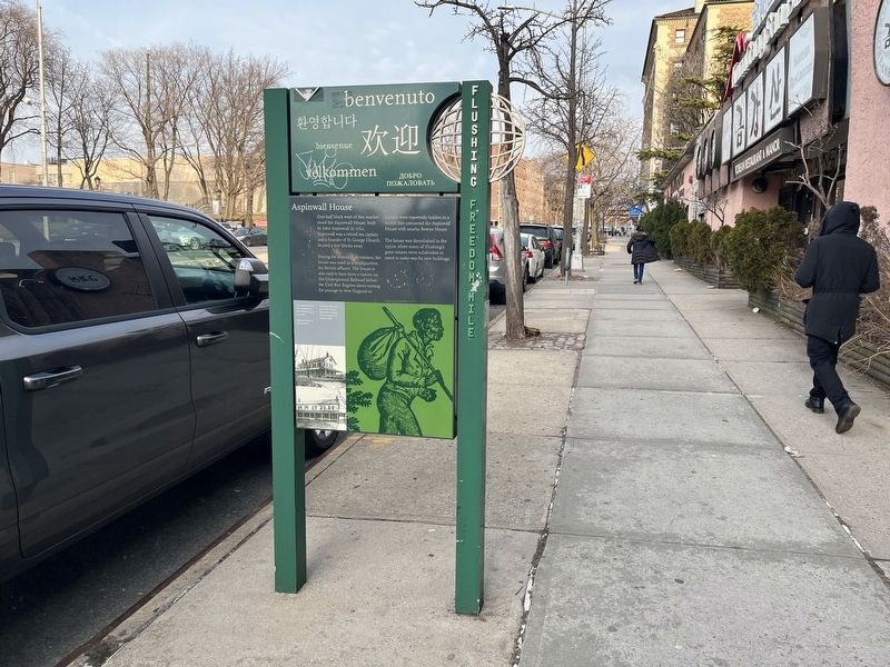
On Northern Boulevard (New York State Route 25A) just east of Union Street, on the right when traveling east.
One-half block west of this marker stood the Aspinwall House, built by John Aspinwall in 1762. Aspinwall was a retired sea captain and a founder of St. George Church, located a few blocks away.
During the American Revolution, the house was . . . — — Map (db m193360) HM
On Bowne Street just south of 37th Avenue, on the left when traveling south.
This house, built by John Bowne in 1661, featured prominently in the early struggle for religious freedom in America. It was the first place of worship for Flushing's Quakers, who were forbidden by Dutch governor Peter Stuyvesant to practice . . . — — Map (db m193358) HM
On Main Street at Northern Boulevard (New York State Route 25A), on the right when traveling south on Main Street.
This square, dedicated in 1943, is named for one of Flushing's most distinguished residents. Daniel Carter Beard (1850-1941) was a civil engineer, illustrator, and naturalist, and a founder of the Boy Scouts of America.
Born in Cincinnati . . . — — Map (db m193404) HM
On Northern Boulevard (New York State Route 25A) just east of Union Street, on the right when traveling west.
Flushing High School was the first public secondary school in New York City, receiving its charter from the State of New York in 1875. At the time, Flushing was an independently governed township with a population of 15,000. Until Flushing High . . . — — Map (db m193421) HM
On Lippman Plaza just south of 39th Avenue, on the right when traveling south. Reported damaged.
Two artists have been commissioned to create sculptures and murals as part of the New York City Economic Development Corporation's and the New York City Department of City Planning's effort to enhance Flushing's streetscape. The artists were . . . — — Map (db m193364) HM
On Northern Boulevard (New York State Route 25A) just west of Union Street, on the right when traveling east.
This site could be considered the birthplace of religious freedom in America. It was here, on December 27, 1657, that a group of brave Flushing freeholders issued a proclamation calling for religious tolerance. One of these men, Michael Milner, . . . — — Map (db m193418) HM
On Northern Boulevard (New York State Route 25A) just east of Linden Place, on the right when traveling west.
This striking Romanesque Revival structure was built in 1862, and served as Flushing's town hall until 1898, when the Village of Flushing was incorporated into New York City.
For many years Town Hall was at the center of Flushing's social, . . . — — Map (db m193413) HM
On Northern Boulevard (New York State Route 25A) at Main Street, on the right when traveling west on Northern Boulevard.
The RKO Keith's Flushing Theatre opened on Christmas Day, 1928, as the Keith-Albee Vaudeville Theatre. In its heyday, performers such as Bob Hope, Milton Berle, Roy Rogers, Jack Benny, Mae West and the Marx Brothers graced its stage. . . . — — Map (db m193407) HM
On Northern Blvd. (New York State Route 25A) at Linden Place, on the right when traveling east on Northern Blvd..
The Friends Meeting House was the first house of worship in the village of Flushing. It is New York City’s oldest house of worship in continuous use, and the second oldest in the nation. The house was built in 1694, and provided Flushing’s . . . — — Map (db m42964) HM
On Bowne Street just north of 37th Avenue, on the left when traveling north.
This stone commemorates one of the most important events in the history of the Quaker community in Flushing. On this site on June 7, 1672, George Fox, the founder of the Religious Society of Friends, preached a sermon.
Fox, an Englishman, . . . — — Map (db m193359) HM
On 37th Avenue, 0.1 miles west of Parsons Boulevard, on the right when traveling west. Reported damaged.
This house is the only surviving example of 18th century architecture in Flushing. It was built ca. 1785 by Charles Doughty, a Quaker farmer, and was named "Kingsland" by his son-in-law, Joseph King. King was an English sea captain who bought the . . . — — Map (db m193347) HM
On Union Street just south of 37th Avenue, on the right when traveling south.
The Macedonia African Methodist Episcopal Church is the third oldest religious organization in Flushing. It started out in 1811 as the African Methodist Society, and welcomed a diverse congregation consisting of blacks, whites and Native . . . — — Map (db m193361) HM
On Bowne Street at 37th Avenue, on the right when traveling north on Bowne Street.
Flushing is considered to be the "Birthplace of Horticulture" in the New World. The first tree nursery in America was established in Flushing by William Prince in 1937. Others soon followed. These nurseries were widely known for their beauty. It . . . — — Map (db m193353) HM
On Lippman Plaza just south of 39th Avenue, on the right when traveling south. Reported damaged.
Orange Trail
The Orange Trail takes you through the busiest streets in Flushing, where historic landmarks endure amidst the noise and bustle of the present. You'll encounter some of Flushing "firsts": Flushing High School, the oldest public . . . — — Map (db m193363) HM
On Leavitt Street at 137th Street, on the left when traveling north on Leavitt Street.
Lewis Howard Latimer was one of the most significant innovators in early electricity pioneering. He purchased this house in 1902 and lived there until his death in 1928. Along with Alexander Graham Bell and Thomas Edison, Latimer helped usher in . . . — — Map (db m193419) HM
On 37th Avenue just west of Parsons Boulevard, on the right when traveling west.
The Weeping Beech Tree that once stood in this park was the first of its species to grow in this country. It was planted in 1847 by Samuel Bowne Parsons, a Flushing nursery owner. Parsons, who provided Manhattan's Central Park with many of its . . . — — Map (db m193351) HM
On Lippman Plaza just south of 39th Avenue, on the left when traveling south.
Founded in 1645 as the first permanent settlement in Queens, Flushing has a rich and exciting history. Originally called "Vissingen" by the Dutch, it started as a tiny, tranquil hamlet within the Dutch colony of New Netherland. Over the past 350 . . . — — Map (db m193362) HM