Totem poles are carved to honor deceased ancestors record history, social events, and oral tradition. They were never worshipped as religious objects.
This totem is the second replication of the Chief Kyan Totem Pole. The original pole was . . . — — Map (db m70746) HM
Ketchikan’s notorious Creek Street, early Alaska’s most infamous red-light district, still retains traces of the gaudy rouge of a half-century of speakeasies and sporting women. Here the fame of Black Mary, Thelma Baker and Dolly Arthur outlived . . . — — Map (db m112039) HM
The Christian cross was planted in Ketchikan's shoreline in 1897, when the settlement was only a creekside collection of Native homes and a trading site for the first white businessman in the area. The missionary priest who staked an ecclesiastical . . . — — Map (db m182004) HM
Laws restricting Chinese and Japanese immigration in the 1920s resulted in a wave of Filipinos coming to work in Ketchikan's booming canneries. These “Alaskeros,” as they called themselves, began to live here permanently and make long-lasting . . . — — Map (db m182101) HM
Dolly Arthur… one of the Creek’s longest “working” residents
This house was the home of Dolly Arthur, Ketchikan’s most famous “sporting woman.”
From 1919 through the 1940s, it was also her place of business.
Dolly, whose given name . . . — — Map (db m112038) HM
At the turn of the century, Ketchikan's pioneer townsite sprouted up from the base of a rugged, uncleared rocky mountainside where it meets deep tidewater. The downtown business district was literally built upon pilings and planked decking, with . . . — — Map (db m181910) HM
The Politics of Prohibition pitted the U. S. Constitution's well-meaning 18th Amendment — which banned the manufacture, sale or transportation of liquor — against the ingenuity of the moonshiners and bootleggers who found ways to satisfy the . . . — — Map (db m182102) HM
In spite of its more respectable Stedman Street address, this building — along with its Creek Street neighbors — was one of the earliest houses of prostitution, built soon after the Town Council banned prostitution to this side of the Creek. . . . — — Map (db m182042) HM
Shipments of iced halibut from Ketchikan to outside markets was pioneered by F.J. Hunt and H.C. Strong, following similar successful methods with salmon, and a thriving business was built through the construction of two large cold storage . . . — — Map (db m181914) HM
On this site over 100 years ago, a 22-foot waterwheel turned, creaked, and groaned to power the Ketchikan Shingle Mill. It was an ingenious creation of pioneer Austin “Ott” Inman.
Inman and his partner, Charles Borch, first used the mill as a . . . — — Map (db m182074) HM
The Revenue Cutter McCulloch is docked near Northern Machine Works (left) and a Japanese barkentine is at anchor on the south end of the wharf near the Ketchikan Spruce Mills (right) to purchase fish. Also visible is St. John's Episcopal . . . — — Map (db m181984) HM
Adventurous Japanese-Americans George and Yayoko Shimizu immigrated to Ketchikan in search of opportunity. Around 1903, they opened the New York Café on downtown Front Street.
Ketchikan was divided racially then. Whites lived north of Ketchikan . . . — — Map (db m182073) HM
Around 1900, adventurous Japanese pioneer George Ohashi came to Ketchikan and opened the New York Café on Front Street. This was the beginning of a three-generation Ohashi family career of entrepreneurial activities.
In 1907, Ohashi built this . . . — — Map (db m182044) HM
For thousands of years, water has been the common highway for all Northwest Coast Natives. Living at the edge of dense rain forests of great cedar, spruce, and hemlock along one of the world's richest sea coasts, their dependence upon seafood . . . — — Map (db m181977) HM
A city arose at the mouth of Ketchikan Creek early in the 20th century, where Native people had camped for uncountable centuries to fish and hunt, houses, stores, hotels and sawmills uprooted the rainforest skyline in a sort of land-rush flurry of . . . — — Map (db m182027) HM
[Left side, top to bottom]
(Top photo) Illegible
The young city of Ketchikan (remainder illegible)
The Sideboard Saloon was operated by town co-founder Mike Martin from early in the century until 1917, when the . . . — — Map (db m181993) HM
E pluribus funum
Independence Day was a bang-up community affair in early-day Ketchikan. In the midst of busy summertime, the Stars and Stripes provided a common denominator for diverse frontier folk. July Fourth inspired considerable . . . — — Map (db m181996) HM
One of Ketchikan's oldest buildings and the Territory of Alaska's only registered brothel.
Infamous owner “Black Mary” Thomas added a dance hall with an inlaid star in the floor, giving the building its name.
Thelma Baker Graham bought the . . . — — Map (db m182087) HM
Hundreds of proud sailing vessels once plied Alaskan waters, but the passing of the wail was swift & complete. As the new Era of the Steamship began to dominate the sea lanes in the late 1890's, Alaska's booming early salmon trade inspired the . . . — — Map (db m181943) HM
Across the great divide: Stedman started apart
Ketchikan Creek formed a dividing line in Ketchikan in the early 1900s. To the north, white pioneers' homes, schools and churches stair-stepped up the hill and businesses crowded the waterfront. . . . — — Map (db m182050) HM
Kichirobei (“Jimmy”) Tatsuda and his wife, Sen Seike, started a combination grocery store, pool hall, tobacco shop and boarding house in 1910.
In 1916, the Tatsudas opened their first grocery store in a nearby building. It was truly a family . . . — — Map (db m182093) HM
Stedman Street was a congenial place for Japanese immigrants and their families up to the 1940s. Japanese-born miners, fishermen, laborers and entrepreneurs settled across the creek from downtown and founded families. Japanese-Americans from the . . . — — Map (db m182058) HM
Our fire department: From buckets to pumpers
Ketchikan Fire Department started in 1900 with a bucket brigade. You were a member if you had a bucket and could carry it full of water. Such rudimentary protection was inadequate in a bustling . . . — — Map (db m181985) HM
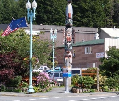
“Thundering Wings” — the title of local master carver Nathan Jackson's magnificent cedar monument, depicts the Tlingit native origin of Ketchikan's name, as told by Chief Reynold Denny of the Beaver Clan:
“About three hundred years ago the . . . — — Map (db m181908) HM
Prior to the 1870s, only a hardy handful of explorers, traders, whalers and sealers worked Alaska's rugged coastline. Following the 1867 purchase of the Territory from Russia, regular boat service from U.S. ports to Sitka began on a monthly . . . — — Map (db m181965) HM
Dedicated to the indomitable spirit of the
sled dogs of the Iditarod Trail Sled Dog Race.
“The Last Great Race on Earth”
Endurance • Fidelity • Intelligence
Dedicated the first Saturday of March, 2012
Historic replica of . . . — — Map (db m80411) HM
Joe Redington, Sr.
Born in Oklahoma, February 1, 1917 • Died in Alaska, June 24, 1999
Joe was an accomplished man; homesteader, big-game guide, bush pilot,
commercial fisherman, boat builder, fish-plant manager, and mountain . . . — — Map (db m80410) HM
In loving memory of
Dean H. Christopherson
1916-1992
Made possible by a generous
contribution from
Mrs. Elaine G. Christopherson
in memory of her husband
The cabin is similar to the cabin at Rohn
the eighth checkpoint on the . . . — — Map (db m80413) HM
The following 72 Inupiat Eskimos are interred in this common grave. Pray, honor and remember these villagers, who lost their lives during the short span of five days, in the influenza pandemic, November 15-20, 1918.
Abeyorok, Mike, 26 • . . . — — Map (db m149930) HM
Sharing Food, Sharing Life – Then and Now
Ukpiaġvik, which means ‘the place where we hunt snowy owls,’ was one of several ancient villages in the Barrow area. Our ancestors settled here primarily to hunt the great bowhead whales. But . . . — — Map (db m49595) HM
This place was central to Russia's hopes of establishing a lucrative colony in America.
Finding a Foothold
Starting in the 1740s, Russians were attracted to Alaska's coast by abundant, valuable sea otters. Russia claimed Alaska and . . . — — Map (db m181348) HM
This site possesses national significance in commemorating the history of the United States of America. The hall is the place of importance in the native community. The original chapter of Alaska Native Brotherhood built this hall in 1914 to serve . . . — — Map (db m133827) HM
On October 18, 1867, the Russian eagle ceded its perch on this hill to the American eagle.
What a Deal!
By the 1860s, the Russian-American Company (RAC), which managed Russia's colonies in Alaska, was losing money, so Russia decided to sell . . . — — Map (db m181361) HM
has been designated a
Registered National
Historic Landmark
under the provisions of the
Historic Sites Act of August 21, 1935
This site possesses exceptional value
in commemorating and illustrating
the history of the United . . . — — Map (db m181330) HM
As Alaska evolved from department to district to territory, and finally, to state, this hill went through a series of changes, eventually becoming Baranof Castle State Historic Site.
Who's the Boss?
A short lull followed the excitement of . . . — — Map (db m181369) HM
Captain George Foster Emmons (1811-1884), commander of the USS Ossipee, sailed into the Sitka harbor with United States
and Russian Commissioners for the ceremony transferring the Alaskan territory to the United States on 18 October 1867.
Nearly . . . — — Map (db m118712) HM
Russians and Native Alaskans took the first tentative steps toward mutual understanding in the Russian Bishop's House. The bishop lived here alongside Tlingit students and Native and Kryol (mixed ancestry) men studying to become Orthodox priests. . . . — — Map (db m181607) HM
This two-story, wood clapboard and gambrel roofed cottage-style house was constructed during the summer of 1916 by the United States Department of Commerce, Coast and Geodetic Survey. Prior to the purchase of Alaska by the United States from the . . . — — Map (db m181580) HM
Blacksmiths and artisans who once lived and toiled on this hill were highly skilled workers of diverse ethnicities. Artifacts found here tell their forgotten story.
Under Your Feet
In 1997, archaeologists discovered Russian workshops . . . — — Map (db m181266) HM
Built about 1895, the Hanlon-Qsbakken house is on the National Register of Historic Places. It was home to three generations of the Hanion-Osbakken family, who trace their roots in Sitka to early Russian American days. The family held the property . . . — — Map (db m181588) HM
When the Kiksadi clan of the Tlingit Indians first migrated into this area from the south, they chose this promontory for the erection of their main houses. There were four of these community houses here when Baranof, governor of the . . . — — Map (db m181334) HM
Baranof and his party landed and parleyed with the Kiksadi who refused to permit another settlement. When the Russians attacked this hill they found the Kiksadi had moved to their fort ¼ mile east on Indian River.
After the battle and siege at . . . — — Map (db m181343) HM
The castle then served as the seat of the United States government until military forces were withdrawn in 1877. Following 1877 there was no government in Alaska until the Organic Act of 1884 authorized the appointment of an Internal Revenue . . . — — Map (db m181358) HM
The first American flag was raised by a colorguard from Company F, 9th Infantry, to signify the transfer of Alaska from czarist Russia.
The first 49 star American flag was raised on July 4, 1959, by a colorguard from the First Battle Group 9th . . . — — Map (db m133863) HM
Imagine your spouse is appointed as the top official in a distant land. You must now travel thousands of miles to Sitka and make this hill your family's new home.
Elisabeth von Wrangell
Ferdinand von Wrangell, the first governor of Russian . . . — — Map (db m181341) HM
They called this place Noow Tlein, Novoarkhangel'sk, and Castle Hill. They were the men who worked, fought, and lived here.
Andrew P. Johnson
1898-1986 — Prominent member of the Kiks.ádi clan and a child of the Kaagwaantaan . . . — — Map (db m181339) HM
Tlingit people established ties to this place long ago and those ties, though altered, remain.
The Land and the Tlingit
The ocean and the forest met the Tlingit peoples' needs as they moved from summer fish camps to autumn hunting grounds . . . — — Map (db m181331) HM
Step across the street to Novo Arkhangelsk, Imperial Russian colonial capital of Alaska and a busy trade center known as the "Paris of the Pacific.” The Bishop's House is the most visible actual remnant of New Archangel. It was built in 1841-42 by . . . — — Map (db m181617) HM
has been designated a
Registered National
Historic Landmark
under the provisions of the
Historic Sites Act of August 21, 1935
This site possesses exceptional value
in commemorating and illustrating
the history of the United . . . — — Map (db m181596) HM
The replica blockhouse before you, a symbol of Russia's role in Alaska's history, represents the walled fortifications that defined the limits of its control.
These blockhouses, or watchtowers, each housing cannons, protected the Russian . . . — — Map (db m133826) HM
On this site was built the first Protestant church in Alaska. It was founded in 1840 when Governor Etholén brought Rev. Uno Cygnaeus from Finland to establish a Lutheran congregation. The Russian-U.S. transfer agreement of 1867 specifically deeded . . . — — Map (db m181567) HM
The 'Cottage-by-the Sea' was constructed in 1897 by Norwegian prospector Captain Hans Christian Pande. While Alaska was still a Territory, the W.P. Mills Company donated this house to the Sitka Woman's Club for a clubhouse, which led to the . . . — — Map (db m241980) HM
Saint Michael's Cathedral, a National Historic Landmark, is the central point of interest in historic downtown Sitka and is recognizable statewide as the most prominent symbol of the Russian colonial presence in Alaska. It was the main edifice of a . . . — — Map (db m181574) HM
Norman E. Staton Sr. and Ethel L. (Milonich) Staton, lifelong Alaskans moved from Ketchikan to Sitka in 1955 opening their first restaurant, the Pioneer Grill on Katlian Street and their second, the Sitka Café on Lincoln Street before opening . . . — — Map (db m181259) HM
This hill's location and the fact that it was once practically an island during high tides made it an ideal and highly defensible site valued by three different nations. Here, the course of Alaska's history changed.
Noow Tlein
The Tlingit . . . — — Map (db m181263) HM
It would be more practical to … erect new [rental] houses … places built in the American way, that is frame houses … — Builder Peter Callsen in a letter dated 1887 to Father Vladimir Donskoi, advising the construction of new . . . — — Map (db m181613) HM
This large frame house was constructed as a Russian residence about 1835. Although there has been some modification the building is thought to be the finest remaining example of Russian secular architecture in Alaska. — — Map (db m133829) HM
Built in 1899 as headquarters for the Arctic Brotherhood Camp Skagway No. 1. The Brotherhood was established February 26, 1899 for the purpose of fraternal enjoyment and mutual aid. Over 30 camps were established throughout Alaska and the Yukon and . . . — — Map (db m72784) HM
This Wells Fargo Store began as the Bank of Alaska on March 20, 1916.
In 1950, Bank of Alaska took on a national character as National Bank of Alaska, and went on to become a pioneer and leader in branch banking in Alaska.
In 2000, National . . . — — Map (db m73328) HM
Captain William Moore first saw the Skagway River Valley and the White Pass in the spring of 1887 when he came with a Canadian survey team to determine the exact position of the 141st meridian separating Alaska and what is now Canada’s Yukon. He was . . . — — Map (db m72783) HM
Frank Reid, guarding the approach to Sylvester's Wharf, where the vigilantes were meeting to restore law and order, shot "Soapy Smith" who failed to stop when challenged, July 8, 1898. — — Map (db m72790) HM
[Seal of the Royal Canadian Mounted Police] In Commemoration of Inspector Charles Constantine and Staff Sergeant Charles Brown North West Mounted Police First members of this historic Canadian police force who landed at Skagway, Alaska . . . — — Map (db m69014) HM
The building before you is an historical structure known as “Jeff. Smith’s Parlor.” It has recently been acquired by Klondike Gold Rush National Historical Park, a unit of the National Park Service. Jeff. Smith’s Parlor, a part of the . . . — — Map (db m72785) HM
Mollie was a resourceful and independent young woman with a wanderlust and love of frontiers. In 1890, she left home at 18 for Butte, Montana where she spent seven years. Landing in Skagway in 1897, Mollie became popular as a waitress and member of . . . — — Map (db m72786) HM
Skagway was originally spelled S-K-A-G-U-A, a Tlingit Indian word for “windy place.” The first people in the area were Tlingits from the Chilkoot and Chilkat villages in the Haines-Klukwan area. From a fish camp in nearby Dyea, they used the . . . — — Map (db m69128) HM
The citizens of Skagway, Alaska wish to forever remember the sacrifices of our military servicemen who died in wartime. These young men left home and community to answer the call to help preserve peace and freedom in the world.
World War . . . — — Map (db m72787) WM
Skagway had a deep-water harbor and was the starting point of the White Pass trail, which began in the river valley and let through the mountains. Skagway was the place where thousands of stampeders started their journey to the Klondike gold mines. . . . — — Map (db m72782) HM
Measuring 50’ X 100’, this was once the largest buildings in Dyea. I was built on pilings for fear of high tide coming up that far in 1898. Warehouses were used to sort out massive piles of mining supplies and bring order to the chaos that had . . . — — Map (db m72788) HM
[Rendering of a loaded pack horse and pack mule] The dead are speaking in memory of us three thousand pack animals that laid our bones on these awful hills during the Gold Rush of 1897-1898. We now thank those listening that heard our groans . . . — — Map (db m69126) HM
Built as McCabe College for Women in 1899-1900. This is the first granite building in Alaska. It served as a Federal Court House from 1901 until statehood when it was purchased by the city of Skagway for a museum. — — Map (db m72789) HM
The community of Big Delta began during the Gold Rush era as a trading post and roadhouse serving prospectors and travelers.
Known for many years as McCarty, Big Delta was a link in the paths of travel and trade. It was located at the . . . — — Map (db m49598) HM
This highway was constructed during World War II as a military supply route for interior Alaska Military and Airfields in 1942. 7 Army regiments and 42 Contractors and Public Roads Administrators working from Delta Junction South and Dawson Creek . . . — — Map (db m59840) HM
The Taylor Highway leads through some of the earliest and richest gold mining country in Alaska to the City of Eagle on the Yukon River. Gold was discovered by Franklin in 1886 and the old town of Forty Mile was located on the Yukon River at the . . . — — Map (db m49596) HM
From 1911-1938 the Copper River & Northwestern Railway was the lifeline for the Kennecott mines. Nicknamed the “Can't Run & Never Will” by its skeptics, the CR&NW overcame incredible challenges in its construction and operation.
Blasted and . . . — — Map (db m173891) HM
“In constructing high trestles and in laying steel track on beds of ice and snow, storms, high winds, and extreme cold tried the patience and fidelity of the strongest and most faithful.” — Cordova Daily Alaskan April 1, . . . — — Map (db m173892) HM
Widely used today on the Yukon and Copper Rivers, the fishwheel was introduced in Alaska near the turn of the 20th century. It is thought to have been prominent in the Pacific Northwest, particularly the Columbia River, prior to making its way to . . . — — Map (db m173903) HM
Visible from here are two prominent mountains: Mount Drum and Mount Wrangell. Both are volcanoes, but their silhouettes suggest a difference in their eruption histories. The younger Mount Wrangell is a shield volcano, a broad-dome mountain built . . . — — Map (db m173912) HM
The U.S. Army arrived at Valdez during the Gold Rush to build a trail into the interior. They found the Valdez Glacier impassable much of the year. To bypass the glacier, they cut a narrow trail along the walls of rugged Keystone Canyon. The . . . — — Map (db m49611) HM
On the far side, just above the water are the remains of the old sled trail, used in the early days. It was cut out of the rock, just wide enough for 2 horses abreast. 200 ft. above can be seen the old goat trail. This road was used till 1945. — — Map (db m49610) HM
“The Iron Trail” by Rex Beach describes these events and this area.
This tunnel was hand cut into the solid rock of Keystone Canyon and is all that is left of the “railroad era” when nine companies fought to take advantage . . . — — Map (db m49609) HM
President Warren G. Harding, first U.S. President to visit Alaska traveled here to pound the Golden Spike signalling completion of the Alaska Railroad from tidewater to the interior July 15, 1926.
State of Alaska
Governor Walter J. Hickel . . . — — Map (db m42948) HM