On South Technical Boulevard south of U.S. 6, on the right when traveling south.
The U.S. Naval Ammunition Depot, known locally as "the NAD," was the largest of the navy's World War II inland munitions depots, occupying almost 49,000 acres of Adams and Clay County farmland. Construction began in July 1942; loading, assembly, and . . . — — Map (db m78005) HM
On West 2nd Street (Business U.S. 6) east of North Hastings Avenue, on the left when traveling east.
For more than 30 years after the turn of the century, the Stein Brothers Store provided quality merchandise from all over the world to south central Nebraska shoppers. Stein's buyers made regular trips to Europe purchasing goods, like Belgian lace . . . — — Map (db m187774) HM
On West 70th Street, 0.4 miles west of Shiloh Avenue, on the right when traveling west.
Susan C. Haile was born December 20, 1817, in Cape Girardeau, Missouri. She was the youngest child of Joseph and Prudence (Bledsoe) Seawell, natives of Sumner County, Tennessee. Upon the death of Joseph in 1819, Prudence Seawell returned to Sumner . . . — — Map (db m123807) HM
On County Road 198, 0.1 miles east of L Street (524th Road), on the right when traveling east.
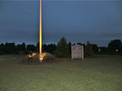
A marker, 200 feet to the south, recalls the death of White Buffalo Girl of the Ponca tribe. The death of this child, daughter of Black Elk and Moon Hawk, symbolizes the tragic 1877 removal of the Ponca from their homeland on the Niobrara River to . . . — — Map (db m182053) HM
On N Street south of East 2nd Street, on the left when traveling south.
With the establishment of the Neligh Mill and the platting of the town of Neligh, a crossing of the Elkhorn River here aided farm-to-market commerce. This bridge, built in 1910, replaced an earlier span at this location. It is a pin-connected Pratt . . . — — Map (db m158998) HM
On East 2nd Street at N Street, on the left when traveling west on East 2nd Street.
The Neligh Mills, built from locally fired brick in 1873 by John D. Neligh, was the first business and industry in the then newly platted town. Later owners and operators of the mill included William C. Galloway, Stephen F. Gilman and J. W. Spirk. . . . — — Map (db m159000) HM
On L Street (U.S. 275) at Riverside Park Road, on the left when traveling north on L Street.
The Rainbow Fountain is patterned after the Tanner Fountain at Harvard University in Cambridge, Massachusetts, near Boston. The Tanner Fountain was created by noted designer Peter Walker and received the 2008 Landmark Award by the American Society . . . — — Map (db m237199) HM
On N Street south of East 2nd Street, on the left when traveling south.
A Route and a Power Source: The Elkhorn Valley The Elkhorn Valley was a natural travel corridor into north-central and western Nebraska. Water, wood, and grass provided people and animals the critical resources to move overland wagons. Travel . . . — — Map (db m159076) HM
On N Street south of East 2nd Street, on the left when traveling south.
Water = Power The Elkhorn River was an unlimited source of water power for flour mills and other manufacturing enterprises. But entrepreneurs found the meandering river difficult to harness. Too much water was as bad as too little. The key to . . . — — Map (db m158999) HM
On 513 Avenue, 1.4 miles north of Orchard, on the left when traveling north. Reported permanently removed.
The Prairie States Forestry Project was initiated by President Franklin D. Roosevelt in 1935 to combat the severe wind-caused soil erosion of the Dust Bowl days. From 1935 through 1942, the U.S. Forest Service, working with the Works Progress . . . — — Map (db m9633) HM
On West 2nd Street just west of South Center Street (State Highway 45), on the right when traveling west.
The Village of Burnett was founded in 1880. Officially changed by the U.S. Post Office
to Tilden in 1887 and by the courts in 1902. — — Map (db m160291) HM
On Heath Street at Cedar Street, on the right when traveling west on Heath Street.
The invention of mechanical balers in the mid-1800s led to the use of bales of hay or straw as building blocks. Pioneer builders developed structural bale walls using cuttings of either native prairie flora — baled-hay — or of agricultural waste, . . . — — Map (db m223422) HM
On Front Street (State Highway 14) just north of 10th Street, on the right when traveling north.
”Near this location in July 1855 Logan Fontenelle noted French-Indian leader of the Omaha tribe, was slain in battle with the Sioux.” Petersburg Com’l Club, July 1955 — — Map (db m179380) HM
On Front Street (State Highway 14) just north of 10th Street, on the right when traveling north.
Logan Fontenelle, an interpreter and Omaha chief, was born at Bellevue in May, 1825. His father was Lucien Fontenelle, a noted fur trader both on the lower Missouri River and near Fort Laramie, Wyoming. His mother was a daughter of Big Elk, noted . . . — — Map (db m179377) HM
On Beaver Street (State Highway 39) at 4th Street, on the right when traveling west on Beaver Street.
For more than ten thousand years the Beaver Valley and surrounding prairie, with their abundant water and wildlife, nurtured Native Americans. The Pawnee Indians, whose permanent earthlodge villages were a few miles to the south, claimed this area . . . — — Map (db m181373) HM
On Perkins Road (State Highway 2) just east of County Road 57, on the left when traveling east.
In the spring of 1942 the U.S. Army selected a site one mile south of here for an airfield. The dry climate and open landscape afforded ideal flying conditions. Ample water, cheap land, and Alliance’s new power plant, new hospital, and railroad . . . — — Map (db m178807) HM
On Box Butte Avenue just south of West 18th Street, on the right when traveling south.
By the mid-1880s the Sandhills had become an important cattle-raising region. The extension of the Burlington and Missouri Railroad westward through the Sandhills in 1877-1888 made ranching more profitable by making more accessible eastern markets. . . . — — Map (db m178801) HM
On State Highway 87 at Dodge Road (State Highway 7E), on the right when traveling north on State Highway 87.
A flat-topped hill to the southeast was named Box Butte by early cowboys and travelers. This area is part of the Box Butte Tableland, semi-arid short grass country that stretches far to the west.
Box Butte has given its name to the creek that flows . . . — — Map (db m89342) HM
On Sampson Street just north of Outlaw Trail Scenic Byway (State Highway 12), on the right when traveling north.
On this day the Lewis and Clark Expedition to the Pacific Ocean camped on the bank of the Missouri River at the base of a river landmark near here, now called The Tower. Clark wrote, “Capt Lewis & my Self walked up to the top which forms a Cone and . . . — — Map (db m181800) HM
On State Highway 12, on the right when traveling west.
On August 3, 1944, a C-47 transport carrying twenty-eight men of the U.S. Army Air Forces crashed in a ravine six miles southwest of Naper during a severe storm. There were no survivors. It was the largest single military air disaster in Nebraska . . . — — Map (db m70623) HM
On U.S. 20 at milepost 235, on the right when traveling west.
Ainsworth Army Air Field, completed on November 30, 1942, was a satellite of Rapid City Army Air Field and under command of the Second Air Force. The field was one of eleven Army Air Force training bases built in Nebraska during World War II. The . . . — — Map (db m77760) HM
On US 20 (U.S. 20), on the left when traveling east.
Lakeland High School was constructed 20 miles south of this site by ranchers from several rural school districts during the summer of 1934. School began that September with 11 students. Constructed of prairie sod, with a sod roof supported by pole . . . — — Map (db m9623) HM
On North Main Street, 0.1 miles south of East 3rd Street, on the left when traveling south.
Like many Nebraska communities, Long Pine's history is tied to railroad development. When the Fremont, Elkhorn, and Missouri Valley line arrived in 1881, Long Pine became a bustling railroad town. The Chicago & North Western Railroad (CNW) built a . . . — — Map (db m182061) HM
On U.S. 183, 0.3 miles south of Interstate 80, on the left when traveling south.
Through this valley passed the Oregon Trail, highway for early explorers, fur traders, California-bound gold seekers, freighters, and brave pioneers seeking new homes in the West. Traffic was especially heavy from 1843 to 1866. At times as many as . . . — — Map (db m45521) HM
On Court Street (State Highway 10C) at 2nd Street, on the left when traveling south on Court Street.
On Oct. 10, 1871 the Buffalo County seat was by vote located at Gibbon.
On this site was built the first Buffalo County Courthouse in 1873. Hand made brick in base, made from local clay is from this courthouse razed in 1909.
On Oct. 13, 1874 the . . . — — Map (db m79715) HM
On Windmill St Recreation Road east of Lowell Road (Nebraska Route 10C), on the right when traveling east.
Gibbon, on the old Mormon Trail, was the site of a unique experiment in homestead colonization. Originally conceived as a financial venture by Colonel John Thorp of Ohio, the Soldier's Free Homestead Colony was responsible for bringing the first . . . — — Map (db m79880) HM
On 2nd Street near Court Street (Nebraska Highway 10C), on the left when traveling west.
Gibbon, near here, was the site of a unique experiment in homestead colonization. The Soldiers' Free Homestead Temperance Colony was responsible for bringing the earliest settlers, mostly Union veterans, to this locality. Traveling via the Union . . . — — Map (db m79716) HM
James E. Boyd settled near here in 1858 and by 1860 operated a trail ranche supplying travelers on the Platte Valley Overland Route (Mormon Trail). The ranche included 2200 acres of corn and barley. Nebraska Centre Post Office was here until it was . . . — — Map (db m45425) HM
On LaBarre Street at 1st Street, on the left when traveling south on LaBarre Street.
Erected by the descendants of the Soldiers Free Homestead Colony, to honor and perpetuate their names, for their courage and self sacrifice in their pioneering. They arrived in Gibbon, Nebraska, April 7, 1871, by Union Pacific Railroad, seeking . . . — — Map (db m79721) HM
Baldwin Built engine 481 in 1903. The original number was 1902, but was later renumbered 841 in 1915. It was used on the main line branch lines of the Union Pacific Railroad in Kansas until the winter of 1954-55, when it was brought to Kearney . . . — — Map (db m45428) HM
The Boyd House, first frame house in Buffalo County, was built just west of present-day Gibbon in 1864 by brothers James E. and Joseph Boyd. It was the family home of James and Ann Boyd and their children. The two brothers came to the area in the . . . — — Map (db m45468) HM
The Lincoln Highway Association was founded in 1913 to promote a transcontinental automobile route from new York City to San Francisco. Dedicated on October 31, 1913, the route was marked by the letter “L” within red, white, and blue . . . — — Map (db m45520) HM
On 31st Street at Central Avenue, on the right when traveling west on 31st Street.
This garden was planted in memory of Dr. Paul Ambrose who died on American Airlines Flight 77 on September 11, 2001.
"Paul dedicated his career to changing the health care system with an emphasis on physician leadership and prevention. Paul . . . — — Map (db m58905) HM
On Central Avenue near 22nd Street, on the right when traveling north.
This property
has been placed on the
National Register
of Historic Places
by the United States
Department of the Interior
Destroyed by fire
Rebuilt 1940 as
Fort Theatre — — Map (db m58904) HM
This building was constructed in 1898 by the German Baptist Church of the Brethren to serve as a house of worship. It was originally located on the southwest corner of ? Street and Avenue A in Kearney. This congregation used this building until . . . — — Map (db m45467) HM
On 31st Street at Central Avenue, on the right when traveling west on 31st Street.
This gazebo is dedicated to the
memory of the
Good Samaritan Air Crew.
On December 20, 1985, they gave
their lives attempting to save others.
Nancy Brandon
Joan Brown
Craig Budden — — Map (db m58938) HM
On West 11th Street at 6th Avenue, on the right when traveling west on West 11th Street.
In 1847 Brigham Young led the first migration over the Mormon Trail along the north bank of the Platte River, and in 1866 the Union Pacific Railroad pushed its main line westward to this valley, bringing pioneer settlers. However, it was not until . . . — — Map (db m45427) HM
Dedicated in honor and memory
Judge Bruno O. Hostetler
1861 - 1954
Leadership in establishing
college in Kearney
1903
A gift from his daughter
Mrs. Florence H. Raymond
June 19, 1980 — — Map (db m58962) HM
On Central Avenue at 19th Street, on the left when traveling north on Central Avenue.
Long before early French explorers named it the Platte River, or "flat waters," this heartland oasis was a crossroads. Migratory birds, abundant wildlife and Native Americans had been in residence for centuries when the confluence of the Oregon and . . . — — Map (db m58888) HM
On U.S. 30, 0.2 miles east of 46th Avenue, on the right when traveling east.
In the late 1880's, Kearney business leaders envisioned the city as a major manufacturing center. The Kearney Cotton Mill was among the many enterprises launched as part of this venture, which included paper, woolen, and oatmeal mills; plow and . . . — — Map (db m101852) HM
In honor of
George and Venetia Peterson
and
Elias and Mary Yanney
The carillon tower reflects the early history of Kearney State College and the Administration Building located adjacent to this site.
The four columns of the . . . — — Map (db m58961) HM
Loup River Freighters Hotel was built in 1884 by Jerome Lalone, a house painter and wallpaper hanger from Kearney. Mr. Lolone purchased land in the northwestern corner of Buffalo County along the South Loup river in 1883. he built the house along a . . . — — Map (db m45429) HM
This depot was built in 1898 next to the Union Pacific tracks in Shelton. It was moved to this site in September 1975 and was the first building on the grounds of the Trails and Rails Museum of the Buffalo County Historical Society. It was donated . . . — — Map (db m45471) HM
On Central Avenue near 19th Street, on the left when traveling north.
and
Bauer Sundries & Veterinary Supplies
January 1959 - October 1969
Proprietor, Frances R. Bauer
Home of Kearney's last soda fountain
In honor of
George J. and Frances R. Bauer
for their civic mindedness and years of . . . — — Map (db m58857) HM
On Interstate 80 at milepost 271, on the right when traveling west.
West-bound travelers will leave the prairie regions of eastern Nebraska and
enter the Great Plains the next within fifty miles. This semi-arid region stretching from Canada to Mexico and westward toward the Rockies was long known
as the Great . . . — — Map (db m228360) HM
On 25th Road (State Highway 44) 0.1 miles south of W Road, on the left when traveling south.
The trail which followed the south side of the Platte River was the main route to Oregon and California. Fur traders going to the Rocky Mountains took the first wagons over the trail in 1830. Oregon-bound missionaries followed in the mid-1830s, and . . . — — Map (db m53268) HM
On U.S. 30 at 1733 Road, on the right when traveling east on U.S. 30.
In 1888, H. D. Watson established the historic Watson Ranch, at one time containing 8,000 acres, reaching from the fertile Platte Valley on the south to the rolling hills on the north and from downtown Kearney to a point five miles west.
. . . — — Map (db m101853) HM
On 9th Avenue at U.S. 30, on the right when traveling south on 9th Avenue.
In 1903 the legislature appropriated $50,000 to establish a state normal school in central or western Nebraska. After 111 ballots, the State Board of Education chose Kearney as the site. The city donated twenty acres on the west edge of town for a . . . — — Map (db m45500) HM
On State Highway 2, 1 mile east of Ravenna Road (State Highway 68), on the right when traveling east.
From 1934 to 1939, Companies 2741 and 2732 of the Civilian Conservation Corps occupied a camp near this site. Barracks housed about 200 men, ages 18 to 25, who built soil conservation dams and planted shelterbelts on nearby farms. The camp moved to . . . — — Map (db m181771) HM
On Grand Avenue (State Highway 68) at East Syracuse Street, on the right when traveling north on Grand Avenue.
In memoriam John Pesek Ravenna, Nebraska 1894-1978 World Champion Wrestler Recognized September 13, 1937 This statue made possible by grant from Nebraska Arts Council citizen donations and Ravenna Chamber of Commerce Dedicated May . . . — — Map (db m236861) HM
On State Highway 2, 1 mile east of Ravenna Road (State Highway 68), on the right when traveling east.
The ill-fated Pleasanton Nebraska branch extended southwestward along the South Loup Valley from Boelus to Pleasanton, a distance of 22.42 miles. Construction from Boelus to Nantasket was completed in 1887 and reached Pleasanton in 1890. The line . . . — — Map (db m181793) HM
On State Highway 2, 1 mile east of Ravenna Road (State Highway 68), on the right when traveling east.
On the South Loup River southwest of here was the site of the U.S. Army’s Post South Loup Fork. This small outpost of Fort Kearney was established in May 1865 by Company “E”, Seventh Iowa Cavalry, under the command of Capt. James B. David and . . . — — Map (db m181699) HM
On U.S. 30 at South D Street, on the right when traveling west on U.S. 30.
In April 1860 Joseph E. Johnson, a Mormon, established a road ranche at Wood River Center, today’s Shelton, and began publishing The Huntsman’s Echo, the first newspaper in Nebraska west of Omaha. He had earlier edited papers in Council Bluffs, . . . — — Map (db m45423) HM
On U.S. 30 at South C Street, on the left when traveling west on U.S. 30.
This Boulder is dedicated to the early pioneers of the community of Shelton, in recognition of their heroic services in establishing and protecting this town and in risking their lives that Shelton might be secure.
In memory of La Belle Whitney . . . — — Map (db m45283) HM
On U.S. 75, 0 miles north of O Street, on the right when traveling north.
(South Side)
Old block house was built by U.S. War Department on this site in 1855 to protect white colony from Indians.
Crowning achievment of the pioneers was a gold medal award for best agricultural display at World's Fair 1893 . . . — — Map (db m28077) HM
On South 4th Street (State Highway 15) just south of Kansas Street, on the left when traveling south.
With the faith and courage of their forefathers who made possible the freedom of these United States The Boy Scouts of America dedicate this copy of the Statue of Liberty as a pledge of everlasting fidelity and loyalty 40th Anniversary . . . — — Map (db m181434) HM
Moses Shinn and his son Dick began operating Shinn's Ferry across the Platte in 1859. The original site was near Savannah, the first Butler County seat, and a short distance from the present Schuyler bridge. Just above this location the Platte was . . . — — Map (db m39143) HM
Butler County was organized in 1868.
The site of Savannah,
the first county seat (1869-72) was located one half mile west and two and one half miles north of this point.
Shinn’s Ferry, established in 1858 directly north of this point proved . . . — — Map (db m236151) HM
"Love is more like a light that you carry .... that is what love is to a woman - a lantern in her hand," says Abbie Deal the courageous heroine in Bess Streeter Aldrich's novel about the pioneers who with dreams and hard work forged this great . . . — — Map (db m82510) HM
This Property
is listed in the
National Register
of Historic Places
By the United States
Department of the Interior
Blake Building 305 Main Street 1883 ca
John Blake, proprietor of a local saloon, erected this building. The . . . — — Map (db m78059) HM
This Property
is listed in the
National Register
of Historic Places
By the United States
Department of the Interior
Budweiser Building 1888
Anheuser-Busch Brewing Co built for $20,000 to house a saloon and liquor business. . . . — — Map (db m78051) HM
Near Main Street, on the right when traveling west.
Two markers, to the left and right of the front entrance.
Has been placed on the
National Register
of Historic Places
By the United States
Department of the Interior
1985
This Property
is listed in the
. . . — — Map (db m78049) HM
On Main Street west of North 6th Street, on the right when traveling west.
When the outbreak of war between the states became imminent in the spring of 1861, the citizens of Plattsmouth were quick to respond to the impending crisis. Without waiting for President Lincoln's call for volunteers, Dr. Robert R. Livingston . . . — — Map (db m78024) HM
This Property
is listed in the
National Register
of Historic Places
By the United States
Department of the Interior
Drew/Weckbach 317, 321, 325 Main Street 1881 & 1886
Joseph V. Weckbach came to Plattsmouth in 1865. After . . . — — Map (db m78056) HM
This Property
is listed in the
National Register
of Historic Places
By the United States
Department of the Interior
Excelsior Building 313 Main Street 1884
Three business owners, in succession, J.C. & R. Peterson, brothers, . . . — — Map (db m78058) HM
On Livingston Highway (U.S. 34), on the right when traveling east.
This Property
is listed in the
National Register
of Historic Places
By the United States
Department of the Interior
Plattsmouth Bridge 1930
The bridge was built to replace the ferry service that had started in 1848. It was . . . — — Map (db m78061) HM
This Property
is listed in the
National Register
of Historic Places
By the United States
Department of the Interior
Vienna Bakery 329 Main Street 1881
Built by William Stadelman, First occupant was a bakery run by William . . . — — Map (db m78054) HM
This Property
is listed in the
National Register
of Historic Places
By the United States
Department of the Interior
Wetenkamp Building 337 Main Street 1890
Many businesses occupied this site. Among them were various stores, . . . — — Map (db m78053) HM
On State Highway 50, on the left when traveling north.
This building was constructed by community effort in 1871 of native limestone as the Congregational Church and served in that capacity until a new brick church was constructed 1887-1890. The nearby stone parsonage, first occupied in 1867, was sold . . . — — Map (db m82521) HM
During their exploration of the Missouri and Columbia Rivers, Lewis and Clark held councils with Ponca, Omaha, and Sioux Indians inhabiting this region. The council with the Sioux occurred August 28-31, 1804 at Calumet Bluff now the southern . . . — — Map (db m101395) HM
On August 27, 1804, the Lewis and Clark Expedition set up its camp for four days downstream from Calumet Bluff. The explorers came across three American Indian boys who told them of a large Yankton Sioux camp nearby.
Knowing that President . . . — — Map (db m101392) HM
You are within sight and sound of a Midwestern dream come true - the Meridian Highway.
In 1911 a group of Kansans and Nebraskans drafted a plan for a highway paralleling the sixth principal meridian through America's heartland from Canada . . . — — Map (db m101393) HM
This scenic overlook provides a clear view of the valley of the Missouri River,
the longest waterway in North America. To the west is the Gavins Point Dam and
the Lewis and Clark Recreation Area. The dam was built to harness the fury of
the . . . — — Map (db m101391) HM
The Missouri, the continent's longest river, figures prominently in the unfolding of America's saga. Flowing nearby in its 2,341 - mile course from the Rocky Mountains to the Mississippi, the Big Muddy is not only loaded with sediment but . . . — — Map (db m101394) HM
On South Broadway Avenue north of East Franklin Street (State Highway 84), on the right when traveling north.
Much of the early history of Cedar County involves the Indian inhabitants, the Ponca, Omaha, and Sioux. Several prehistoric and historic Indian villages were located in the region. In 1804, Lewis and Clark ascended the Missouri River near here . . . — — Map (db m181311) HM
On West Franklin Street (State Highway 84) east of South Robinson Avenue, on the left when traveling east.
This marker, dedicated on the 100th anniversary of Hartington High School, June 25, 1988, is in honor of two graduates who became governors of Nebraska. Dwight Burney, born in 1892, graduated from Hartington High School in 1910. Burney attended . . . — — Map (db m181317) HM
Champion, on the Frenchman River (Creek), is the site of probably the oldest functioning water-powered mill in Nebraska. Preliminary construction on the mill was begun in the fall of 1886. The work was completed and the mill placed in operation by . . . — — Map (db m79376) HM
On Bodeman Park Drive just north of U.S. 6, on the right when traveling north.
Near this spot stood the Rowley sod house. Built in 1875 it was the first habitation in Chase County. On October 3, 1878, while on his way home to protect his family, Rowley was killed by Cheyenne Indians during the epic trek of Dull Knife’s Band . . . — — Map (db m177410) HM
The first ranch in this area was set up on the Niobrara River about five miles south of here in 1877. E. S. Newman established his ranch to sell cattle to the government for delivery to the Indians at the Pine Ridge Agency to the north.
The . . . — — Map (db m9622) HM
On State Highway 61, 0.2 miles north of Survey Valley Road, on the left when traveling north.
This natural valley extending east and west across the Sandhills became known as Survey Valley after the Burlington and Missouri River Railroad surveyed a prospective line from O’Neill to Alliance in 1887. No rails were ever laid. On January 19, . . . — — Map (db m178711) HM
On U.S. 20, 3 miles west of U.S. 83, on the left when traveling west.
This arched cantilever truss bridge, connected in the center with a single pin, is the only one of its kind in the United States. It was built in 1932 by the Department of Public Works and named by the local citizenry in honor of Governor Charles . . . — — Map (db m70625) HM
On U.S. 20 at milepost 198, on the right when traveling west.
When a Sioux Indian reservation was established north of here in Dakota Territory in 1878, early settlers in the region grew fearful of attack. They requested military protection, and in 1880 Fort Niobrara was built a few miles east of present-day . . . — — Map (db m77753) HM
On U.S. 20 at milepost 221 east of Main Street, on the right when traveling west.
At 10:45 a.m. on February 5, 1944, 1st Lt. John B. Beatty of Sandusky, OH, and 2d Lt. Earnest W. Fanslau of Mantua, NJ took to the air from the Ainsworth Army Air Field in two P-47 "Thunderbolt" fighter planes for an instrument training flight. Lt. . . . — — Map (db m77754) HM
On Gold Rush Byway (U.S. 385) 0.3 miles south of Local Road 38, on the left when traveling north.
On August 9, 1949, the first successful oil well in western Nebraska came in for 225 barrels of oil per day at a total depth of 4,429 feet. Marathon Oil Co. completed the discovery well, Mary Egging No.1, located four miles east and two miles . . . — — Map (db m223425) HM
On Main Street (Lincoln Highway) (U.S. 30) at Road 79, on the right when traveling east on Main Street (Lincoln Highway).
On June 1, 1926, George A. Coulter completed one of the first four irrigation wells in Cheyenne County, among the earliest in western Nebraska, on his farm just south of here. He and his son, James, dug the first twenty-two feet by hand. Charles . . . — — Map (db m231142) HM
On Front Street at Elm Street, on the left when traveling west on Front Street.
Potter began as a small Union Pacific Railroad settlement and depot midway between Kimball and Sidney. The station house was built by Union Pacific in 1870 and, as the only building in the settlement, also served as the post office and school. Its . . . — — Map (db m231144) HM
Near Interstate 80 (at milepost 61), 1.3 miles east of Upland Parkway (Alternate Interstate 80), on the right when traveling west.
Cheyenne County was organized in 1870 from lands ceded by the Cheyenne, Arapaho, and Dakota Sioux Indians. In the panhandle of Nebraska, it is part of the Cheyenne tableland portion of the Great Plains. Some fifteen miles west of Sidney lies the . . . — — Map (db m231054) HM
On Illinois Street (aka Lincoln Highway) (U.S. 30) at Ball Street, on the right when traveling east on Illinois Street (aka Lincoln Highway).
Sidney Barracks, when established in 1867, was a temporary camp with one permanent structure, a blockhouse located to the north. In 1869 the Fort was relocated at this site and in 1870 the name was officially changed to Fort Sidney. The primary . . . — — Map (db m76864) HM
On Hickory Street at 10th Street, on the left when traveling east on Hickory Street.
Eight plaques mounted on a single monument are located at Hickory Square. The plaques are presented left to right.
Early Day Cheyenne County
The history of Nebraska and Cheyenne County correlate to the push westward of the . . . — — Map (db m76866) HM
On Fort Sidney Road, 0.1 miles north of Deaver Drive, on the left when traveling north.
A distinct group of prehistoric hunter-gatherers known to archeologists as the Oxbow Complex once occupied the northern High Plains from western Nebraska to southern Canada. About 2500 B.C. a band of Oxbow people interred two of their own near . . . — — Map (db m231081) HM
Near Interstate 80 (at milepost 61), 1.3 miles east of Upland Parkway (Alternate Interstate 80), on the right when traveling west.
The Purple Heart medal was originated by General George Washington on August 7, 1782 for distinguished valor and is now awarded only to members of the armed forces of the United States who have been wounded in combat against an armed enemy. . . . — — Map (db m231068) HM
Near Interstate 80 (at milepost 61), 1.3 miles east of Upland Parkway (Alternate Interstate 80), on the right when traveling west.
In 1867 an Army tent camp was established near here to provide protection for Union Pacific Railroad construction crews. Three years later it became Fort Sidney, the nucleus for the town of Sidney, county seat of Cheyenne County. The rush to the . . . — — Map (db m231061) HM
998 entries matched your criteria. The first 100 are listed above. Next 100 ⊳