On Rockville Road (County Road 15) at Stimpson Sanctuary Road, on the right when traveling south on Rockville Road.
William Bartram, America’s first native born artist-naturalist, passed through Clarke County during the Revolutionary era, making the first scientific notations of its flora, fauna and inhabitants. As the appointed botanist of Britain’s King George . . . — — Map (db m101568) HM
On Main Street (U.S. 84) at College Street, on the right when traveling north on Main Street.
In profound appreciation of the Boll Weevil and what it has done as the Herald of Prosperity this monument was erected by the Citizens of Enterprise, Coffee County, Alabama — — Map (db m30306) HM
Near Natchez Trace Parkway (at milepost 327.3), 2.7 miles east of N Pike (County Route 21), on the left when traveling east.
The Natchez Trace Parkway is designed to encourage leisurely exploration of the history and beauty of Old Southwest. Here are a few pointers to make your trip more enjoyable.
Regulations and Safety
Obey posted speed limits. Be alert for . . . — — Map (db m107254)
Near Natchez Trace Parkway (at milepost 327.3), 1.6 miles N Pike (County Route 21), on the left when traveling east.
Alabama’s Winter Waterfowl
The Tennessee River Valley is the winter home for thousands of waterfowl. These birds migrate from across the northern US and Canada down through the center of the continent to the Tennessee River.
Careful . . . — — Map (db m107253) HM
Many Kinds of Birds Call North Alabama Home
The northern tier of Alabama has two distinct landforms-the Tennessee River Valley and the Appalachian Plateau. A variety of terrain provides wonderful birding habitat and offers excellent . . . — — Map (db m150937) HM
Just downstream from Wilson Dam lies a series of trails maintained by the Tennessee Valley Authority. Starting at the Visitor Center, explore the trails as they meander along the riverbank and through the forest
1.Wilson Dam Visitor Center . . . — — Map (db m106186) HM
Gulls are a Diverse and Fascinating Group of Birds
Popularly known as sea gulls, these birds actually occur at the seashore and far inland as well. Each winter thousands of gulls gather along the Tennessee River. Three species form the . . . — — Map (db m106184)
Scan the wooded island just across the Tennessee River for numerous bundles of sticks scattered through the canopy. These bulky structures are the nest of Great Blue Herons. Dozens of these nests are scattered across the island, and each year Great . . . — — Map (db m106179) HM
The Muscle Shoals National Recreational Trail complex is a 17-mile paved and primitive trail and bikeway for public use located on TVA’s Muscle Shoals Reservation. This National Recreation Trail System connects numerous historical sites including . . . — — Map (db m106117) HM
Escape to an Earlier Time The giant trees of Northern Alabama's mature forest have stood throughout generations, witnessing considerable natural, historical, and cultural changes. Some probably witnessed the Civil War while others only date . . . — — Map (db m117058) HM
Alabama is one of the states with the most biodiversity.
In fact, Alabama ranks #1 when it comes to the number of freshwater critters!
Biodiversity refers to the total number of different plant and animal species.
Every organism from . . . — — Map (db m106105)
Birdwatching is a popular hobby for many in Alabama. Not only are birds fun to watch, but they also tell us a lot about environmental health.
Pileated Woodpecker • Red-tailed Hawk • Yellow-bellied Sapsucker • Cardinal • Bluebird • American . . . — — Map (db m106103) HM
Near Cahaba Road at Capitol Street, on the right when traveling north.
"Cahawba's magnificent churches,
splendid mansions and business houses
will become the habitations of owls and
bats," predicted a concerned citizen
in a letter to the editor of the Dallas
Gazette in February of 1857. He
warned . . . — — Map (db m245237) HM
Near Cahaba Road at Capitol Street, on the right when traveling north. Reported permanently removed.
"We by-and-by discovered...a pair of those
splendid birds, the Ivory-billed Woodpeckers
(Picus principalis). They were engaged in
rapping some tall dead pines, in a dense part of
the forest, which rang with their loud notes." . . . — — Map (db m112801) HM
On Museum Avenue at Main Street (U.S. 84), on the right when traveling south on Museum Avenue.
A mule trader for 65 years, was known throughout the nation for the slogan,"'Tolable' fair dealer". Opposite this site, on the southeast corner of East Main and Holman Streets stood one of the south's largest mule stables. Built in 1917, the . . . — — Map (db m83784) HM
On City Park Road south of Kentucky Avenue (Alabama Route 17), on the left when traveling south.
Alabama’s Winter Waterfowl
The Tennessee River Valley is the winter home for thousands of waterfowl. These birds migrate from across the northern US and Canada down through the center of the continent to the Tennessee River.
Careful . . . — — Map (db m106298) HM
On Cahaba Road at Park Lane, on the right when traveling north on Cahaba Road.
In 1822 William Pullen, Revolutionary War veteran, acquired this land from the Federal Government for farming. In 1889 his heirs sold the land to the City of Birmingham for use as the New Southside Cemetery which operated from 1889 to 1909 with . . . — — Map (db m27096) HM
The Forks of Cypress plantation was established in 1818 by James and Sarah Jackson. Its home, believed the design of William Nichols, was one of Alabama's great houses, featuring perhaps the earliest peristyle colonnades in America. Built by skilled . . . — — Map (db m83975) HM
On Jackson Road (County Road 41) 0.8 miles south of West Rasch Road (County Road 16), on the right when traveling south.
The Forks of Cypress plantation was established in 1818 by James and Sarah Jackson. This home, believed the design of William Nichols, was one of Alabama's great houses, featuring perhaps the earliest peristyle colonnades in America. Built by . . . — — Map (db m156982) HM
Near Hightower Place near Veterans Drive (Alabama Route 133), on the left when traveling south.
Often referred to as the most successful breeder of thoroughbred horses in America, James Jackson imported Glencoe and Leviathan to the U.S. in the early 1800's, leaving a permanent imprint on both the breed and American racing history. — — Map (db m219334) HM
When the Alabama Department of Conservation and Natural Resources began a Bald Eagle Restoration Project in 1984, Bald Eagles had not successfully nested in Alabama since 1949. Thanks to these restoration efforts, Bald Eagle populations increased . . . — — Map (db m107997) HM
On Lauderdale County 1 (County Route 1) 1.5 miles north of Lauderdale County 14 (County Route 14), on the left when traveling north.
When the Alabama Department of Conservation and Natural Resources began a Bald Eagle Restoration Project in 1984, Bald Eagles had not successfully nested in Alabama since 1949. Thanks to these restoration efforts, Bald Eagle populations increased . . . — — Map (db m105709) HM
On Lauderdale County 1 (County Route 1) 0.8 miles north of Lauderdale County 14 (County Route 14), on the left when traveling north.
Birds Come From All Directions to Enjoy the Tasty Treats Hidden Beneath the Mud
In the late summer. fall, and winter, reservoir levels in the Tennessee River Valley drop drastically to expose areas of mudflats. although unsightly to some, theses . . . — — Map (db m105713) HM
Near Alabama Route 33, 0.2 miles south of County Route 67, on the left when traveling south.
A Special Place: for People and Birds
The forest of Bankhead have been here for many generations, witnessing considerable natural, historical and cultural changes. This area was home to native Americans for many years. The pioneers who live . . . — — Map (db m107295) HM
Near Alabama Route 33, 0.2 miles south of County Route 67, on the left when traveling south.
Many Kinds of Birds Call North Alabama Home
The northern tier of Alabama has several district landforms including the Tennessee River Valley and the southern Cumberland Plateau. The variety of terrain and the large expanse of forest in the . . . — — Map (db m107297) HM
Near Alabama Route 33, 0.2 miles south of County Route 67, on the left when traveling south.
Discover the Incredible Variety of Habitats and Birds in the Bankhead National Forest
1. Walston Ridge Road
The road along Walston Ridge provides a variety of forest habitats. Prescribed fire maintains the open oak-pine woodlands. . . . — — Map (db m107294) HM
Near North 5th Street north of Park Road, on the right when traveling north.
Opelika's Board of Parks and Recreation hired W.J. "Bill" Calhoun as its first director in 1951. His top priority was to develop a wooded area behind Northside School. Two adjacent parcels of land were donated by I.J. Scott, Sr. and Winston Smith . . . — — Map (db m210764) HM
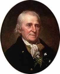
On Nick Davis Road (County Road 44) 0.5 miles west of Sanderson Road (County Road 127), on the left when traveling west.
Born April 23, 1781 in Hanover Co. Virginia, married there to Martha Hargrave of a wealthy Quaker family. He served as U.S. Marshall and in other positions. Moved to Kentucky in 1808. Was a Captain in the War of 1812 and became a political and . . . — — Map (db m29284) HM
The Alabama red-bellied turtle was placed on the U.S. Fish and Wildlife Service’s Endangered Species List in 1987 and is of the highest conservation concern.
Alabama red-bellied turtles live almost exclusively in the fresh and brackish water of the . . . — — Map (db m144914) HM
Near Tranquility Base, 0.5 miles west of Madison Pike, on the left when traveling west.
Able, an American-born rhesus monkey, and Baker, a South American squirrel monkey, were launched on May 28, 1959, aboard an Army Jupiter missile. Launched in the nose cone, the two animals were carried to a 300-mile altitude, and both were recovered . . . — — Map (db m239330) HM
On Cadillac Avenue west of Grant Street, on the right when traveling west.
John F. Porter, Jr. Goat Tree Reserve
John F. Porter, Ph.D. served as volunteer Executive Director of Dauphin Island Bird Sanctuaries, Inc. (incorporated as Friends of Dauphin Island Audubon Sanctuary) from its inception in 1992 until his . . . — — Map (db m151634) HM
Let all who read these words of gratitude and praise know that tens of thousands of America's fighting men and women owe their lives to the deeds and courage of war dogs and their handlers. Further, let it be known that many breeds of dogs, large . . . — — Map (db m74162) HM WM
On East Fifth Street at Jean Street, on the right when traveling east on East Fifth Street.
Side 1
Remount Depot
During World War I, in the summer of 1917 the U.S. Army opened a remount depot here to buy horses and mules for Camp Sheridan's 27,000-man 37th Division from Ohio. Despite the introduction of motor transport . . . — — Map (db m71340) HM
On State Street (Alabama Route 116) at McKee Street (Alabama Route 39), on the right when traveling south on State Street.
Earliest known Morgan Horse in Alabama and one of the three major stallion sons sired by Justin Morgan, foundation sire of the breed. Woodbury was foaled in 1816 in Vermont, where he remained until sold to Norman Bugbee of Gainesville, Alabama, . . . — — Map (db m69710) HM
On North Norton Avenue at West 4th Street, on the left when traveling north on North Norton Avenue.
Founded in 1896 by brothers John Judge and Milton Graham Hightower, this small-town livery stable served the community and surrounding countryside until its closing in 1955. Originally located nearby, the business moved to this “New . . . — — Map (db m57763) HM
Some Points about Quills:
*Porcupines have approximately 30,000 quills which cover every part of the body except the underside, face and ears.
*Quills are modified hairs that are barbed, lightweight, and filled with spongy substance. . . . — — Map (db m170937) HM
Good Clean Livin The largest bear enclosure in the United States is found here at the Alaska Wildlife Conservation Center. Solar electricity powers the electric fence that encloses 18 acres of land, and water is pumped into the pond by the . . . — — Map (db m170904) HM
Calves are born mid-May to early June. Cows give birth to twins 15 to 75 percent of the time and triplets occur about once in every 1,000 births.
Calves stand within minutes and begin eating vegetation a few days after birth.
Calves stay . . . — — Map (db m70720) HM
Top Predators
Eagles will prey on any animal they are capable of overtaking including ducks, gulls, porcupines, foxes and rabbits. The primary tool used to catch and kill prey are its feet. Equipped with needle sharp talons and powerful tendons, . . . — — Map (db m170902) HM
High above river valleys, at overlooks like this, Denali’s first human visitors watch for mammoth, giant bison, and caribou. Ridge tops made the best game launching platforms; herds tend to follow sheltered stream corridors.
Hunters had to . . . — — Map (db m69724) HM
A square, white wooden tower housed the Guard Islands light, with a separate keeper's house nearby. When a reinforced concrete building replaced the old light tower in 1922, a second house was built so two keepers could live there with their . . . — — Map (db m181640) HM
Ships arriving in Juneau in the 1930's could count on being met at the dock by a small, white dog named Patsy Ann. A local dentist, Dr. E.H. Kaser, brought the English bull terrier as a puppy from Portland, Oregon in 1929. Although loved and . . . — — Map (db m181734) HM
Fifty years after Patsy Ann met her last ship, admirers led by June Dawson organized the Friends of Patsy Ann. The group raised funds and commissioned a statue so Patsy Ann could once again greet visitors on the dock.
Sculpted by Ann Burke . . . — — Map (db m69663) HM
On South Knik-Goose Bay Rd, on the right when traveling north.
Dedicated to the indomitable spirit of the
sled dogs of the Iditarod Trail Sled Dog Race.
“The Last Great Race on Earth”
Endurance • Fidelity • Intelligence
Dedicated the first Saturday of March, 2012
Historic replica of . . . — — Map (db m80411) HM
Sharing Food, Sharing Life – Then and Now
Ukpiaġvik, which means ‘the place where we hunt snowy owls,’ was one of several ancient villages in the Barrow area. Our ancestors settled here primarily to hunt the great bowhead whales. But . . . — — Map (db m49595) HM
[Rendering of a loaded pack horse and pack mule] The dead are speaking in memory of us three thousand pack animals that laid our bones on these awful hills during the Gold Rush of 1897-1898. We now thank those listening that heard our groans . . . — — Map (db m69126) HM
Widely used today on the Yukon and Copper Rivers, the fishwheel was introduced in Alaska near the turn of the 20th century. It is thought to have been prominent in the Pacific Northwest, particularly the Columbia River, prior to making its way to . . . — — Map (db m173903) HM
On Lehner Road, 2 miles north of Palominas Road & State Highway 92, on the left when traveling east.
At this location in 1952, a large bone bed was discovered containing the remains of extinct mammoth, tapir, bison and horse. Found with the bones were the weapons and tools of the Indians who had killed and butchered these animals. The bones and . . . — — Map (db m43633) HM
On North Garden Avenue near Sherbundy Street, on the right when traveling north.
The Carmichael House was built by William and Margaret Ziegan Carmichael on 131.05 acres. On December 11, 1911, Margaret, a single woman at the time, purchased the property from John and Ellen Reilly for $8,000. As the years passed, the Carmichael . . . — — Map (db m27894) HM
On Toughnut Street east of 5th Street, on the left when traveling west.
At 1:00 p.m. on April 21st, 1907, the "Million Dollar Stope" was created when the Good Enough Stope caved in dropping a horse and wagon 75' into a gaping hole. The driver had climbed down to see why his horse had stumbled only to find himself . . . — — Map (db m131088) HM
In 1857 Congress authorized Navy Lieutenant Edward F. Beale to survey a wagon road along the 35th parallel from Fort Defiance, New Mexico Territory, to the Colorado River. A secondary mission was to test the feasibility of using camels in the . . . — — Map (db m33348) HM
On North Gemini Drive, on the right when traveling north.
From 1857-60, Lt. Edward F. Beale and a crew of 100 men completed the first federal highway in the southwest from Fort Smith, Ark. to Los Angeles, Calif. at a cost of $200,000. The wagon road was used extensively by immigrants en route to California . . . — — Map (db m33346) HM
Near East Aspen Avenue west of North San Francisco Street.
The rich diversity of plants and animals of the Flagstaff area was first recognized in the summer of 1889 when Dr. C. Hart Merriam led a biological survey to the San Francisco Peaks. Merriam's "Life Zone Theory" detailed that temperature and . . . — — Map (db m201772) HM
On North Leroux Street, on the left when traveling north.
As the keystone shows, this building was constructed in 1911. Its owner was R.O. Raymond, M.D., one of Flagstaff’s first doctors. Raymond came west for his health. After a short stay in Williams, he moved to Flagstaff in 1906.
He was the doctor . . . — — Map (db m59511) HM
On South San Francisco Street, on the right when traveling south.
Historic Basque handball court (cancha) built in 1926 by Jesus Garcia, a Spaniard who migrated to Flagstaff in 1912. He owned and operated the adjacent Tourist Home. The Basque would reportedly herd sheep, drink, chase women, or play their beloved . . . — — Map (db m59498) HM
On North San Francisco Street at East Aspen Avenue on North San Francisco Street.
John G. Verkamp came to Flagstaff in the 1890s. He first worked for the Babbitts (three of his sisters were married to Babbitt brothers), then succeeded in a number of businesses on his own, including lumber, livestock and merchandising. He is best . . . — — Map (db m59505) HM
Behind you is the Bright Angel mule corral, where each morning mules greet riders and another adventure begins. Mules have carried people into Grand Canyon since sightseeers first visited here in the 1890s. For many people - including those who . . . — — Map (db m205170) HM
On Arizona Route 67 at U.S. 89A, on the right when traveling south on State Route 67.
Has been designated a
National Natural Landmark
This site possesses exceptional value as an illustration of the Nation's natural heritage and contributes to a better understanding of the environment. — — Map (db m94912)
On Jordan Road at Navahopi Road, on the right when traveling south on Jordan Road.
Lee Van Deren, cattleman, arrived to put his children in the new Sedona school opened in 1910. Ranching was a major part of Sedona’s early economy. Round ups and cattle drives were a twice a year occurrence for ranchers when moving their herds from . . . — — Map (db m54229) HM
On East Railroad Avenue near South 9th Street, in the median.
"Old Bill" was born January 3, 1787 in North Carolina. He died March 24, 1849. In that 62 year life span he did a heap of living, most of it in the wilderness. In the late 1700's and early 1800's the mountain men were trappers. In the quest of fine . . . — — Map (db m205150) HM
On Bouse Avenue, 0.5 miles south of Arizona Route 72, on the left when traveling south.
Thomas Bouse was born in Mendecino County, California and came here about 1889 as a prospector and built the first two rooms of his home. He ran a small store here. He brought his wife, Katherine, and infant daughter here in 1892. Three more . . . — — Map (db m29070) HM
On Broad Street (Arizona Route 72 at milepost 27) south of Main Street, on the right when traveling west.
He was our drinking buddy
While on duty
He drank our beer
He was
Full of good cheer
And went to the nurses' quarters around the bend
And came to an untimely end,
Of the Colonel, he was unaware
That it would be the crime of all time . . . — — Map (db m78536) HM
Near Hi Jolly Road, 0.2 miles north of Quartzsite Boulevard.
The famous camel herd with which the name of Hi Jolly is linked constitutes an interesting sidelight of Arizona history.
Jefferson Davis (afterward president of the Southern Confederacy), as Secretary of War, approved a plan to experiment with . . . — — Map (db m70566) HM
On U.S. 60 east of Center Street, on the right when traveling west.
This desert town was made famous by the humor of Dick Wick Hall, healthseeker and operator of the laughing gas station. Hall's publication the Salome Sun was filled with extravagant tales of the desert's adaptation of species. He told of his frog . . . — — Map (db m31824) HM
Near Bloody Basin Off-Road Trail, on the left when traveling east.
Marker 1 - (Main Marker):
The original Verde River Sheep Bridge, also known as the Red Point Sheep Bridge, was constructed at this location in 1943 by Flagstaff Sheep Company, which had been grazing sheep in the area under a Forest . . . — — Map (db m53966) HM
Near South Marcos Place near West Commonwealth Avenue, on the right when traveling north.
He knew no yesterdays
His living was for tomorrow
Founder of the town of Chandler
Built the San Marcos Hotel
Arizona’s first veterinarian
Father of modern irrigation system
Pioneer rancher and developer of the southside area of . . . — — Map (db m70990) HM
The corrals here are the remnants of the sprawling complex of corrals and pastures needed to raise the livestock that was always important to the operations of Sahuaro Ranch.
In early years, horses and mules were the primary source of power for . . . — — Map (db m40686) HM
Although some cows were probably always kept on the ranch to supply fresh milk and butter, it was not until after Richard W. Smith bought Sahuaro Ranch in 1927 that dairy cows were raised here commercially.
At first the Smith family sold only . . . — — Map (db m40662) HM
Little is known about the history of this building, which started out as a horse stable, but it almost certainly was one of the earliest work buildings to be erected at Sahuaro Ranch.
The eastern half, with the vertical wood siding, was built . . . — — Map (db m40685) HM
The barnyard was the center of activity as Sahuaro Ranch. Horses and mules were stabled, trained, and shoed here. Cattle were brought to the corrals for branding, treatment and shipment. Farm implements and wagons were stored and repaired here. . . . — — Map (db m40674) HM
This concrete trough was part of the E.A. Tovrea Memorial Zoo.
In June 1942, the Phoenix Gazette announced the opening of a zoo featuring Arizona wildlife. The small zoo housed bison (like the one pictured here) elk, deer, antelope, coyote, . . . — — Map (db m142633) HM
On North Tegner Street at East Apache Street, on the right when traveling north on North Tegner Street.
b. July 12, 1899 Hope, NM
d. October 25, 1971 Wickenburg, AZ
Known as the cowboy's cowboy
Admired and revered by townsfolk
Father and organizer of Turtle Association 1936 which became the Professional Rodeo Cowboy Association
1937 Owned . . . — — Map (db m29473) HM
Near Andy Devine Road (Business Interstate 40) near Grandview Avenue.
Pioneer in the path of empire hero of the War with Mexico, lieutenant in United States Navy. Appointed general by the Governor of California. Commanded exploration of wagon route to the Colorado River, with the only camel train in American History . . . — — Map (db m32208) HM
On Oatman Highway (Old U.S. 66) at Rock Hound Hill Road on Oatman Highway.
This turn of the century gold mining camp was on the original road through the Black Mountains and eventually became Route 66. Burrows came with the miners and still roam the streets today.
Get you Kicks on Route 66 in Arizona. — — Map (db m188974) HM
On Main Street, on the right when traveling north.
World War I was funded partially by the gold out of these mountains in 1912. Oatman boomed from 1910 to the 1920's. Upwards to 8,000 people lived here. Gold mines were closed about 1942. Mines were needed to mine copper for World War II. Blue Ridge . . . — — Map (db m119942) HM
On Oatman -Topock Highway / Main Street (Old Route 66 at Rock Hound Road, on the left when traveling north on Oatman -Topock Highway / Main Street (Old Route 66.
Oatman was founded around 1906 as part of Arizona's richest gold mining area. Oatman was reborn in the late 1960's and early 1970's as a tourist town. The main attraction was the wild burro herd. The burros roaming the Oatman area are descendants of . . . — — Map (db m78570) HM
On Oatman Topock Hwy ( AZ 66 ) near Bannon Lane, on the right when traveling south.
Oatman was founded about 1908. By 1931,
the area's mines had produced over
1.8 million ounces of gold. By the mid 1930's,
the boom was over and in 1942 the last
remaining mines were closed as nonessential
to the war effort.
Burros first . . . — — Map (db m18964) HM
Oatman was founded about 1908. By 1931, the area's mines had produced over 1.8 million ounces of gold. By the mid 1930's, the boom was over and in 1942 the last remaining mines were closed as nonessential to the war effort.
Burros first came to . . . — — Map (db m114819) HM
The Sonoran Desert can be described as a “desert jungle” because more than 200 species of animals and 600 species of plants live here. Saguaros---with their branching arms and accordion-like pleats—dominate this scene. Intermixed with these cacti . . . — — Map (db m83147) HM
This famous track on the banks of the Rillito River was the birthplace of many racing innovations still in use today. The Southern Arizona Horse Breeders Association, the organization that pioneered Quarter Horse Racing in Tucson, had been hosting . . . — — Map (db m83215) HM
On East Cam Correo south of Interstate 10, on the right when traveling east.
Established June 14, 1887. A small conical red peak gave Red Rock its name. Red Rock was a major cattle shipping point via the S.P. Railroad. This post office celebrated its
Centennial in June 1987. — — Map (db m31190) HM
On Arizona Route 83, 0.1 miles south of Arizona Route 82, on the right when traveling south.
Seeing whose horse was fastest or who had the best working ranch horse was a natural form of competition for early settlers in Arizona cattle country. So began the race and show tradition at Sonoita. The Sonoita Quarter Horse Show began at the Santa . . . — — Map (db m46881) HM
In 1932, Charles Bell constructed this trail through the rugged canyon of Wet Beater Creek. It was, and still is, used to move cattle up and down the Mogollon Rim. Bell Trail is six miles to the edge of the Rim and climbs a rocky 1200 feet in the . . . — — Map (db m187583) HM
Could This Stone Be The Opening to a Macaw Pen?
Where Did This Stone Come From?
Who Used It?
Why Is This Stone at Montezuma Castle?
Did the Ancient Sinaguans Possibly
Raise Macaws Here?
In the 15th century, near modern-day Casa . . . — — Map (db m40895) HM
On South Cortez Street just north of West Goodwin Street, on the left when traveling north.
The Water Table By March of 1881, fire wells like this one were hand-dug on the four corners of the Courthouse Plaza. At the time, the water table was high enough to allow bucketing of water for fire emergencies. These wells were abandoned . . . — — Map (db m157663) HM
The Ruffner Plaza Stables were built on this lot purchased from Frank Murphy for $3,600. In May 1898, a local newspaper reported that it was "one of the most substantial as well as ornamental improvements which has been put up for several . . . — — Map (db m20297) HM
On West Gurley Street, on the left when traveling west.
This free-spirited Son of the West, sensitive to the changing era in which he lived, portrayed the western epic in marble and bronze. Our "Bucky O'Neill" monumental bronze is among his greatest works, and is acclaimed by art critics as one of the . . . — — Map (db m21165) HM
Little Horse Park, now called the Chapel area, was originally a mixture of private and US Forest Service property. Lee Piper homestead there and Otto Hallermund held the Forest Service-issued grazing permit for the area – part of the Sedona . . . — — Map (db m133690) HM
On Chino Street (Arizona Route 66) at Main Street, on the right when traveling east on Chino Street.
From 1857 to 1860 Lt. Edward F. Beale and a crew of 100 men built the first federal highway in the southwest. The 1857 Beale Expedition used 22 camels and dromedaries for pack animals. This road went from Fort Smith, Arkansas to Los Angeles, . . . — — Map (db m32206) HM
Near Prison Hill Road, 0.5 miles north of Harold C. Giss Parkway.
Restoration in Progress The Yuma East Wetlands (YEW) is an innovative restoration project pioneered by the Quechan Indian Tribe and the City of Yuma. The 1,418 acres of the YEW are comprised of native riparian wetland, and aquatic habitats . . . — — Map (db m158390) HM
On Main Street (State Highway 23) at Grand Avenue, on the right when traveling north on Main Street.
The Eureka Springs Railroad opened in February, 1883. As the first trains arrived at the original station house, a finely crafted wooden structure, passengers were met by horse drawn carriages and hacks which quickly carried them to the best . . . — — Map (db m80173) HM
On Kelso Road, 0.3 miles east of State Route 1, on the right when traveling east.
In mid-February 1863, Confederate troops at Cypress Bend fired on Union transports on the Mississippi River. On Feb. 19, a force of Union cavalry and mule-mounted infantry set out in pursuit. The Union troops drove off enemy pickets before . . . — — Map (db m107693) HM
On Fountain Street, 1.2 miles north of Central Avenue (State Highway 7), on the left when traveling west.
Spas thrive on pleasant diversions. In contrast to sedate Bathhouse Row, Happy Hollow developed a a free-wheeling carnival atmosphere.
At the turn of the century, Norman Mcleod opened an amusement park in the vicinity of this cold spring and . . . — — Map (db m145652) HM
Near Central Avenue (Arkansas Route 7), on the right when traveling south.
Horse racing had its origins
in the early history of Hot
Springs. Farm boys brought their
horses into the small settlement
to race them prior to the Civil
War. Formal racing began in the
1890s. The Essex and Oaklawn
tracks began operations in . . . — — Map (db m211177) HM
On Chaney Drive at Riverbank Rd., on the left when traveling east on Chaney Drive.
This dog park is named in honor of Batesville native
Sara Elizabeth Low. Throughout her youth, she was
known for her kindness and helpfulness to others. Sara
carried these traits through adulthood and was remembered
for them by fellow crew . . . — — Map (db m242386) HM
On SW 2nd Street at West Main Street (U.S. 412) on SW 2nd Street.
Much of what we currently know and enjoy
as Walnut Ridge is built upon the work of an
enterprising, 19th Century businessman by the
name of John Rhea. His life, and even his death,
are the stuff of local legend.
John A. Rhea was born in . . . — — Map (db m170301) HM
3956 entries matched your criteria. The first 100 are listed above. Next 100 ⊳