The bear has long served as a symbol of Berne, Indiana. Founding fathers named this community after Bern, Switzerland, the area in "the old country" from which the town's settlers had emigrated in 1852. These settlers would have been accustomed to . . . — — Map (db m227614) HM
Settled 1852 by seventy devout Mennonite immigrants who came direct from Switzerland. Town platted 1871, named for capital of Switzerland. — — Map (db m227586) HM
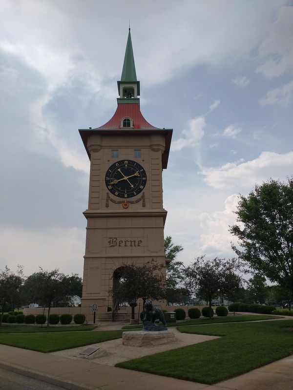
This monument is dedicated to the early settlers of Berne, Indiana, eighty-two devout Mennonite immigrants who came from the Bernese Jura of Switzerland. The first generations cleared the land and drained the swamps, building a future for those of . . . — — Map (db m227612) HM
Decatur was selected as a County Seat on May 18, 1836. The founders were Samuel Rugg and Thomas Johnson. Decatur was surveyed by Jacob Hofer. The land for the site was owned by Thomas Johnson. Decatur was selected by a special county board comprised . . . — — Map (db m211666) HM
Adams County formed 1835. Geneva incorporation 1874 included early towns Alexander and Buffalo. During 1890s oil boom, population and businesses grew. Fire destroyed much of town 1895; Geneva Board of Trustees banned wooden buildings, mandated . . . — — Map (db m63824) HM
In Southern Adams County as the pioneers came into the new country, the necessity of school was realized. The McHugh school was built near this site in 1837 or 1838 and is reputed to be the first public school in Adams County along with the Gorsline . . . — — Map (db m227615) HM
Platted 1866 by Benjamin Meiser, John L. Peabody and Patrick Ney at the crossroads adjacent to the Peabody Steam Sawmill (1853) and the Fort Wayne, and Chicago Railroad (1855). The post office name was changed from Taw-Taw to Arcola in 1858. — — Map (db m226585) HM
Allen County was created on April 1, 1824, by a
December 1823 act of the Indiana General Assembly.
The newly created county was named for Col. John
Allen of the Kentucky militia who had helped relieve
the siege of Fort Wayne in 1812 and who was . . . — — Map (db m197324) HM
Fort Wayne business had a start on Duck Street, named for the 19th century Duck Creek that drained the area from the higher ground near Superior Street into the St. Mary’s River. Along Duck Creek in the 1840s and 50s stood the City Mills, one of the . . . — — Map (db m16997) HM
The confluence area of the Three Rivers was known to the native people since as early as the end of the last Ice Age, more than 10,000 years ago. As the glaciers melted and receded, they paused here creating a high point in the topography of the . . . — — Map (db m17064) HM
Because of the often soggy conditions that discouraged use as either residential or commercial property, the area of Headwaters Park became known as the Jail Flats. The first jail in Allen County was a two-story hewn-log structure that was enclosed . . . — — Map (db m197061) HM
Johnny Appleseed legendary planter of orchards across Ohio, Indiana, and Illinois, was a real person named John Chapman. He was a friend to all God's creatures and a missionary for the Swedenborgian religion, a Christian denomination.
He was . . . — — Map (db m21560) HM
Miami Chief Mishikinakwa or Me-she-kin-no-quah, known to the Euro-Americans as Little Turtle, born circa 1747, played a significant role in the settlement of the area surrounding the confluence of the Three Rivers. He was the most successful Native . . . — — Map (db m197057) HM
Most often the rivers here brought prosperity. They are the reason humanbeings settled here; established a land portage to connect with the Wabash River system; and attracted the canal followed by rails, highways, industry, and homes. They brought . . . — — Map (db m17030) HM
This Barr and Columbia Street intersection is the center from which Civic Fort Wayne Grew
North West
Barnett-Hanna Trading Post 1819
First Post Office 1820
North East
Suttenfield Tavern 1823
South West . . . — — Map (db m197325) HM
The "Old Well," an important factor in the existence of the fort and its people, saved the fort from Indian fire brands in 1812. Fort Wayne was first built, near by, in 1794. It was rebuilt, on this site, in 1804, and 1815.
Research by . . . — — Map (db m21210) HM
Terminal point where French-Canadian boats, hollowed from 30-60 foot poplar logs, brought families and cargo up the Maumee River from Toledo and Detroit, and returned furs to Lake Erie in exchange for traders' supplies, from the late 1700's until . . . — — Map (db m16957) HM
The Last Two American Forts
In 1798, Col. Thomas Hunt began construction on this site of the second American fort at the Three Rivers. this fort, which was completed in 1800, replaced the first, hastily built one erected nearby to the . . . — — Map (db m21219) HM
This area of the Three Rivers was a site of settlement of Native Americans for as much as 10,000 years. The collection of villages known as Kekionga, located in the present-day Lakeside neighborhood, was a center of the Miami nation in historic . . . — — Map (db m21501) HM
The Saint Mary's River and the St. Joesph River converge in Fort Wayne to form the Maumee River. The most important geographical feature of the area is the short distance overland between the Three Rivers system, which eventually flows to the . . . — — Map (db m239133) HM
A capsule was buried on this site on May 11, 2002 when citizens of Takaoka and Fort Wayne met to re-affirm an alliance established in 1977. The capsule, containing articles related to the 25th anniversary, will be opened on the occasion of the . . . — — Map (db m239279) HM
9 January 1865. Patrick H. Keegan sold this half-lot to carpenter James C. Dillon who built a frame, one, and one-half story house.
28 June 1889. His three daughters sold this house to Patrick H. Keegan.
21 April 1914. Mr. . . . — — Map (db m197188) HM
In 1852 John Brown, a stonemason, built this last remaining vestige of the early canal era in FortWayne.
A native of Glasgow, Scotland, Brown came by canal boat to Allen County in 1847 with his wife Mary. He and his Scottish business partner, . . . — — Map (db m100141) HM
The Edsall House, the oldest structure in downtown Fort Wayne and the city's second hospital, was built by William S. Edsall in 1839. Edsall was a fur trader, builder, ferry operator, surveyor, sawyer and merchant, and was prominent in Fort Wayne . . . — — Map (db m215660) HM
Edsall (1811-1876) was an early community leader, serving on the first City Council, and later was a land office register and County Clerk. He was also a fur trader, merchant, plank road and railroad builder in the Fort Wayne area and helped Fort . . . — — Map (db m215666) HM
Illsley. "Illsley" was the name of the large estate of Frank Illsley Brown and Anna Bond Brown. Their stately Italianate home faced west toward the St. Mary's River and was surrounded by extensive gardens. The front of the property on . . . — — Map (db m225926) HM
Originally in twenty three lots at a site selected by the Wabash Railway for a depot to serve a rich agricultural area. The first steam train arrived over the newly completed Fort Wayne-Toledo right of way on January 1, 1902. A post office was . . . — — Map (db m183600) HM
On north bank of prehistoric Lake Maumee. The ridge formed by the bank was part of the pioneer overland trace from Detroit to Fort Wayne. This route was surveyed as early as 1837 for the ridge road, served in the late nineteenth century as a toll . . . — — Map (db m183602) HM
Once an Indian trail directly through these school grounds, the route followed by General Anthony Wayne's army in its departure from the fort in 1794 and the way by which General William Harrison's troops came to the relief of the garrison at Fort . . . — — Map (db m211614) HM
First called "The Opening", a natural clearing in the forest, settled about 1837. On the old Lima Plank Road connecting Howe (Lima) and Fort Wayne. Home of the Perry Centre Seminary, founded 1856 and closed 1861 when the entire faculty and all adult . . . — — Map (db m76402) HM
Colonel John Hardin, of the Kentucky Militia, with 180 men and Captain John Armstrong, U.S. Army, with 30 men, were routed here on October 19, 1790, by Indians under Miami Chief Little Turtle during General Harmar's Campaign. — — Map (db m232339) HM
Monroeville, Indiana was in a vast wooded area, with many lumber mills, stave and barrel factories in operation.
At one time it was the home of Lloyd C. Douglas, noted writer. Here he obtained the incentive to write some of his books, . . . — — Map (db m211610) HM
First town incorporated in Maumee Township. Once called "Phelps Station" on the Wabash Railroad. A strategic point in a vast woodland of timber unsurpassed in the United States for variety and condition.
Incorporated as a 5th class city in . . . — — Map (db m193534) HM
From 1830 to 1880 the community of Lowell Mills thrived here along Driftwood River. There were two grist mills, a cooperage, a shoemaker's shop, a distillery, a saw mill, a woolen mill, an inn and general store. When the mills closed, the town was . . . — — Map (db m63794) HM
Our Pioneer Heritage
Here, from the days of the frontier, the covered wagon, the Indian Wars, come reflections which make us feel humbly grateful for the vision, courage and sacrifice of our pioneer forebears which made possible the community . . . — — Map (db m242295) HM
To the memory of
Gen. John Tipton
1786-1839
Founder of Columbus, Indiana
Gen. Joseph Bartholomew
1766-1840
Our county bears his name
Both heroes at Tippecanoe — — Map (db m242302) HM WM
Forever honoring the pioneers of Montpelier and the community who built the foundation for the freedom we cherish today.
1836 - 1976 — — Map (db m222231) HM
Black southerners established a thriving, free community around Thorntown in Sugar Creek Township by the early 1850s. Most became farmers and some owned property, despite Indiana's constitutional prohibition of black settlement. By 1870, this . . . — — Map (db m174247) HM
Site of
First Post Office, Lot No. 4, 1853
Postmaster: John W. Vaughn
First Dry Goods Store and Grocery Store, Lot No. 4, 1852
Wiley & Vaughn
First House erected
John Miller’s hous, Lot No. 1, 1852
and Boarding House
Zion . . . — — Map (db m175807) HM
Patrick H. Sullivan, 1794-1879, was the first white settler in Boone County, 1823, and built the first log cabin. In 1857, he bought this site and lived here until 1872. He served in the War of 1812. — — Map (db m67190) HM
In the beautiful Eagle Creek valley of southeastern Boone County, a new town was planned on land owned by Elijah and Mary "Polly" Cross.
Convinced by Lebanon businessman William Zion, a director of the Lafayette & Indianapolis Railroad, the . . . — — Map (db m8328) HM
Laid out in 1828 by David Stipp. Promoted for seat of a new county to be made partly from the Great Miami Reserve, which began two mile east. The Lafayette & Muncie Road crossed the Great Michigan Road here. It was an important stage stop, mill . . . — — Map (db m42709) HM
Side A
Camden
When the School Section, No. 16, was sold in 1832 Wm. Crooks, School Commissioner, reserved 16 acres and had a town site laid out by John Armstrong, Co. Surveyor. Col. Crooks (1787 - 1861) (War of 1812) kept the first . . . — — Map (db m42713) HM
Marie Harris, Ellen Hostetler and Nancy Farrier, in memory of their parents John David and Ruth Marie Hilderandt Rhine
John and Ruth were both lifetime residents of Carroll County. They loved this part of Indiana and its history. In 1961 they . . . — — Map (db m163347) HM
Creating a Life in the Wilderness
The Canal Village is comprised of buildings constructed
during the canal era. The water in back of you is the only
remaining accessible and recreational watered segment of
the Wabash & Erie Canal in . . . — — Map (db m163315) HM
90 lots platted in 1836 on both sides of Wabash - Erie Canal lock.
A Post office in 1838 - 39. The lock passed canal boats into the river on the pool of the Great Dam at Pittsburg five miles below. The mules carried the towline across the . . . — — Map (db m35413) HM
Named and platted in 1828 by Gen. Samuel Milroy, on 100 acres donated by Wm. Wilson for the seat of Carroll Co., named for Charles Carroll, last surviving signer of the Declaration of Independence. Henry Robinson was the first settler. . . . — — Map (db m1154) HM
The City Beautiful. Platted in 1828 by General Samuel Milroy
on land donated as the county seat by William Wilson, was an
industrial center during boom days of the Indiana Canal era. — — Map (db m161449) HM
In October 1818, Purchasing Commissioners Lewis Cass, Benjamin Parke and Governor Johnathan Jennings acquired Indian claims on the land shown on this marker. About one-third of modern Indiana was involved in this transaction. — — Map (db m1152) HM
Along the Monon Tracks
This building originally served as the post
office in Sleeth, a rural community in
Carroll County about nine miles northwest
of Delphi. Sleeth was also known as
McCoy's Station on the Louisville, New
Albany, & . . . — — Map (db m163341) HM
Here at Chief Winamac's old village, about 900 Potawatomi Indians camped on their forced removal from Indiana to Kansas. A child and a man died here during the encampment. They also left behind 24 too sick to continue. — — Map (db m35399) HM
Great Place to Visit
Enjoy yourself, take your time, bring your camera and
your fishing tackle, watch the clouds reflected on the
Wabash, experience the spirit of a nineteenth century
downtown square, walk a tree lined trail along the . . . — — Map (db m163356) HM
Flora’s Station, on the Logansport, Crawfordsville and Southwestern Ry., was platted in 1872 for John Flora on land entered by him in 1829. Ino Post Office established 1872, changed to Flora in 1873. Also called Fountain City from flowing wells. . . . — — Map (db m42711) HM
On September 11, 1838, about 850 Potawatomi Indians camped at Pleasant Run, having traveled 17 miles that day on the forced removal from Indiana to Kansas. — — Map (db m35400) HM
Pyrmont. John Wagner built a dam, race and saw mill about a mile South in 1833 and added a grist mill. He sold to John Fisher who sold to John Fetterhoff who built a large frame mill. Joel Wagoner, James Allen, Elias Morkert, J. J. Cripe, Wm. . . . — — Map (db m40455) HM
On terrace to south, during 18th century, was a 3-mile row of little wooden shacks, metropolis of the E.R. Miami. Old records, maps show it as ye Olde Towne, Kenapaco-maqua (Snakefish), Eel River Town, L'Anguille.
Among Olde Towne's . . . — — Map (db m224634) HM
Wilkinson's Expedition. 525 Kentuckians burned Olde Towne: after a skirmish in Bloody Hollow and an Aug. 8. 1791 battle here had killed ten Indians and two soldiers, including John Bartlett; and wounded John Stafford. 34 of the . . . — — Map (db m224655) HM
Dedicated to the early Logansport Settlers whose unmarked graves reside at the Ninth Street Cemetery Emoline R. Ward • Emma Ward • Chauncey Ward • H Ward • Lucy Ward • Ellen Webster • Mrs Wedekind • Annie Weirick • Henry Weirick • John Weisman • . . . — — Map (db m242058) HM
First American settlement in the Northwest Territory. 150,000 acres granted to George Rogers Clark and his troops by Virginia in 1781 for war services. Town named and tracts occupied by 1784. — — Map (db m203544) HM
The earliest settlement in Jeffersonville was ca. 1786 with the construction of Fort Finney near what is now the John F. Kennedy Memorial Bridge. A settlement grew around the fort which was renamed Fort Steuben in 1791, honoring Baron von Steuben, . . . — — Map (db m206910) HM
Founded 1818 by Seth and Zebulon Leavenworth. Ohio River port for keelboats, flatboats, packets. Shipped pork, spirits, produce, corn, lumber, etc. Manufactured skiffs, flatboats, pearl buttons. Crawford County seat, 1843-c. 1895, when "stolen" by . . . — — Map (db m207137) HM
This town of Leavenworth was mainly known for two things, skiffs and buttons. In 1814, Zebulon Leavenworth laid out the town here because of the large fresh water spring at the base of the hill.
Two years later, Daniel Lyon had set up a boat . . . — — Map (db m207098) HM
A canal from Terre Haute to Evansville authorized 1846. Maysville Division along White River was over 23 miles long from Newberry through Owl Prairie (now Elnora) to Maysville; part of it paralleled what is now S.R. 57. Contracts were let June . . . — — Map (db m23203) HM
Platted in 1846 by John Hastings; town named Clarksburg reportedly after George Rogers Clark; post office name was Clark’s Prairie, 1858-1881. Both names changed to Odon, 1881; Odon incorporated, 1885. By tradition, name Odon coined by combining . . . — — Map (db m99006) HM
Built on this site by civilians to protect approximately ten families during War of 1812. Named for landowner David Flora. Ten such forts were built circa 1811-1813 in area that became Daviess County. Area was Knox County, part of Indiana Territory . . . — — Map (db m23211) HM
In 1788 Congress granted 400 acres of land to each French family of this area. The tract was laid off in a square containing 160 separate plots. Additional grants were made affecting the five counties shown. — — Map (db m98935) HM
Aurora was laid out by Jesse L. Holman, trustee for the “Aurora Association for Internal Improvements” in 1819. Judge Holman was an early statesman, preacher, educator, and federal justice.
His son, U.S. Congressman William S. Holman served . . . — — Map (db m22105) HM
At the mouth of Hogan Creek, a short distance from here, Samuel Morrison, first white child born in the county—March 1, 1798. He was a gifted historian, inventor and map-maker, and drew a number of early maps published for Indiana. — — Map (db m206646) HM
Originally called Forest Hill, Hillforest was completed in 1855 for local industrialist and steamboat owner Thomas Gaff and his family. Emigrants from Scotland in 1811, the six Gaff children moved with their mother to Aurora in the 1840s and . . . — — Map (db m22125) HM
The town was laid out by Mathias Whetstone in 1830, and named for General James Dill, soldier in the War of 1812, first county recorder, a member of the Indiana 1816 Constitutional Convention, military associate and friend of Generals William . . . — — Map (db m45884) HM
Side 1 Veterans of the Revolution buried here include Capt. Joseph Hayes, Lt. Solomon Hayes, and Thomas Miller, Sr. (PA), and Alexander Guard (NJ).
These patriots were among the first pioneers in the Northwest Territory. The Guard family . . . — — Map (db m149372) HM
Erected 1821 by early settlers as a Methodist Church on land donated by John Ewbank. Services were held continuously for more than 125 years. Maintained by endowment fund. — — Map (db m86236) HM
Plaque One
Captain Samuel C. Vance
Our Founder Plaque Two
In memory of Captain Vance and the pioneer families who endured the hardships of flatboat travel to reach this place in the wilderness.
They lived in log cabins . . . — — Map (db m20604) HM
Birthplace of two Indiana Governors. Albert Gallatin Porter, eighteenth Governor (1881-1885), born here April 20, 1824, died Indianapolis, May 3, 1897; and Winfield Taylor Durbin, twenty-fourth Governor (1901-1905), born here May 4, 1847, died . . . — — Map (db m66907) HM
1802 - - Village of Lawrenceburgh founded in the Wilderness by Capt. Samuel C. Vance
Commerce and travel are via the Ohio River. Pioneers
constructed flatboats to carry goods to New Orleans
Markets. The “Kaintucks” . . . — — Map (db m22029) HM
Army Captain Samuel Colville Vance was a surveyor for the United States government living in Cincinnati, Ohio. In 1802 he purchased all the land comprising the original town of "Lawrenceburgh." At that time the land was part of Hamilton County, . . . — — Map (db m66906) HM
Early fine quality Federal style home of Samuel Vance, built 1818. Military associate and friend of William Henry Harrison. Vance founded Lawrenceburg in 1802. River Boats landed on the grounds, and guests reached the mansion through an avenue of . . . — — Map (db m200326) HM
Built by James Angevine
in York Township around 1830.
The Angevines left New York City
and traveled to Indiana where they
purchased over 1,000 acres of
land in York Township.
James and Susan Angevine
raised 12 children in this cabin
until . . . — — Map (db m222831) HM
James and Susan Angevine moved to
York Township in Dearborn County
in 1818 from New York. This is
the second cabin they built on their
property (c.1820). The Angevines
raised their children in this cabin until
1830. The cabin was used as a . . . — — Map (db m222830) HM
Lawrenceburg was founded in 1802 by Captain Samuel Vance, a U.S. Government surveyor who purchased the land that would become Lawrenceburg. With the beginning of steamboat shipping after the War of 1812, came the evolution of the city's historic . . . — — Map (db m222744) HM
1822 - - - - - - - - - - - - - - - - - - 1922
Colonel Thomas Hendricks
Veteran of the War of 1812
Founded this Town in 1821
He built the first cabin and donated one
hundred acres of ground to the new . . . — — Map (db m44769) HM
Side one:
Luther Donnell was convicted in Decatur Circuit Court (1849) of aiding fugitive slaves, Caroline and her four children, to escape to Canada. In Donnell v. State, Indiana Supreme Court reversed the conviction, claiming that under . . . — — Map (db m44752) HM
On this site stood the log home of Wesley Park, co-founder with John Howe of the City of Auburn in 1836.
Park's cabin was an important social and government
center, serving as a tavern, resting place, and courthouse for early settlers and . . . — — Map (db m60238) HM
Who settled here in Keyser Township,
DeKalb County, state of Indiana in the year 1864
with purchase of three hundred seventy acres
of virgin land and from which in 1882
they donated the tract on which the nearby
Christian Union Church is . . . — — Map (db m159852) HM
Once promoted by its boosters as an ideal location for the Delaware County seat, this community was officially platted in 1836 by John Gregory, David Shideler and Peter Thomas. It is the successor to Georgeville, platted a short distance up the . . . — — Map (db m141446) HM
Joseph Wilson and Uriah Powers first operated a flour mill and a sawmill around which the village of Elizabethtown grew up in the 1830s. Wilson named the town after his daughter, Elizabeth, and had high hopes for the community as a prospective . . . — — Map (db m141424) HM
The Barlett, Bryant, Vannata, and Veach families were the first settlers in 1837-1839.
In 1840-1850 the McCreery, Woodring and Maynard, Rowlett and Thompson families became property owners.
Snagtown ~ New Corner was platted by David L. . . . — — Map (db m141475) HM
The first school house in Delaware County was erected in a trackless forest one half mile west of this site. “Indian Jim,” the last of the Delaware tribe remaining in this county, a highly respected resident
hewed the black walnut logs . . . — — Map (db m141163) HM
Several principal Indian and Pioneer Paths cut across Indiana and Delaware County
connecting trading and warrior routes of ancient times. First made by migrating large animals searching for salt, followed by Native Americans for food, trade and . . . — — Map (db m141410) HM
This boulder marks the traditional
site of Wah-Pe-Kah-Me-Kunk
the White River Town of the Muncee Clan of Delaware Indians.
It is, also, a memorial to Joshua, a Christian Indian, who was burned by the tribe, March 1806, a martyr to his . . . — — Map (db m141131) HM
574 entries matched your criteria. The first 100 are listed above. Next 100 ⊳