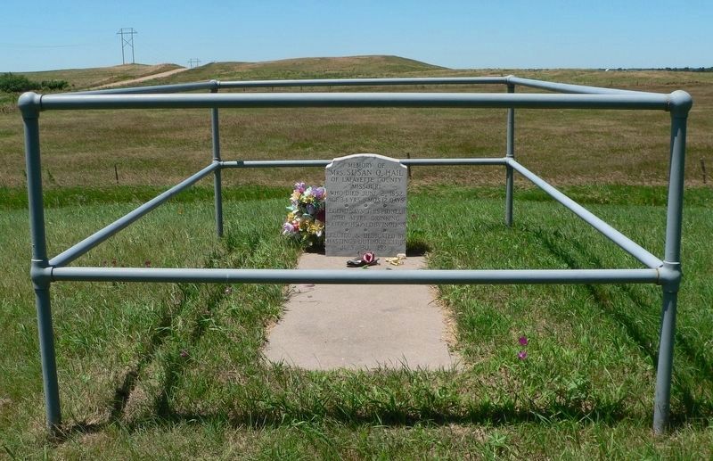
Susan C. Haile was born December 20, 1817, in Cape Girardeau, Missouri. She was the youngest child of Joseph and Prudence (Bledsoe) Seawell, natives of Sumner County, Tennessee. Upon the death of Joseph in 1819, Prudence Seawell returned to Sumner . . . — — Map (db m123807) HM
A marker, 200 feet to the south, recalls the death of White Buffalo Girl of the Ponca tribe. The death of this child, daughter of Black Elk and Moon Hawk, symbolizes the tragic 1877 removal of the Ponca from their homeland on the Niobrara River to . . . — — Map (db m182053) HM
A Route and a Power Source: The Elkhorn Valley The Elkhorn Valley was a natural travel corridor into north-central and western Nebraska. Water, wood, and grass provided people and animals the critical resources to move overland wagons. Travel . . . — — Map (db m159076) HM
The Village of Burnett was founded in 1880. Officially changed by the U.S. Post Office
to Tilden in 1887 and by the courts in 1902. — — Map (db m160291) HM
The invention of mechanical balers in the mid-1800s led to the use of bales of hay or straw as building blocks. Pioneer builders developed structural bale walls using cuttings of either native prairie flora — baled-hay — or of agricultural waste, . . . — — Map (db m223422) HM
Logan Fontenelle, an interpreter and Omaha chief, was born at Bellevue in May, 1825. His father was Lucien Fontenelle, a noted fur trader both on the lower Missouri River and near Fort Laramie, Wyoming. His mother was a daughter of Big Elk, noted . . . — — Map (db m179377) HM
For more than ten thousand years the Beaver Valley and surrounding prairie, with their abundant water and wildlife, nurtured Native Americans. The Pawnee Indians, whose permanent earthlodge villages were a few miles to the south, claimed this area . . . — — Map (db m181373) HM
A flat-topped hill to the southeast was named Box Butte by early cowboys and travelers. This area is part of the Box Butte Tableland, semi-arid short grass country that stretches far to the west.
Box Butte has given its name to the creek that flows . . . — — Map (db m89342) HM
Lakeland High School was constructed 20 miles south of this site by ranchers from several rural school districts during the summer of 1934. School began that September with 11 students. Constructed of prairie sod, with a sod roof supported by pole . . . — — Map (db m9623) HM
Like many Nebraska communities, Long Pine's history is tied to railroad development. When the Fremont, Elkhorn, and Missouri Valley line arrived in 1881, Long Pine became a bustling railroad town. The Chicago & North Western Railroad (CNW) built a . . . — — Map (db m182061) HM
On Oct. 10, 1871 the Buffalo County seat was by vote located at Gibbon.
On this site was built the first Buffalo County Courthouse in 1873. Hand made brick in base, made from local clay is from this courthouse razed in 1909.
On Oct. 13, 1874 the . . . — — Map (db m79715) HM
Gibbon, on the old Mormon Trail, was the site of a unique experiment in homestead colonization. Originally conceived as a financial venture by Colonel John Thorp of Ohio, the Soldier's Free Homestead Colony was responsible for bringing the first . . . — — Map (db m79880) HM
Gibbon, near here, was the site of a unique experiment in homestead colonization. The Soldiers' Free Homestead Temperance Colony was responsible for bringing the earliest settlers, mostly Union veterans, to this locality. Traveling via the Union . . . — — Map (db m79716) HM
James E. Boyd settled near here in 1858 and by 1860 operated a trail ranche supplying travelers on the Platte Valley Overland Route (Mormon Trail). The ranche included 2200 acres of corn and barley. Nebraska Centre Post Office was here until it was . . . — — Map (db m45425) HM
Erected by the descendants of the Soldiers Free Homestead Colony, to honor and perpetuate their names, for their courage and self sacrifice in their pioneering. They arrived in Gibbon, Nebraska, April 7, 1871, by Union Pacific Railroad, seeking . . . — — Map (db m79721) HM
The Boyd House, first frame house in Buffalo County, was built just west of present-day Gibbon in 1864 by brothers James E. and Joseph Boyd. It was the family home of James and Ann Boyd and their children. The two brothers came to the area in the . . . — — Map (db m45468) HM
In 1847 Brigham Young led the first migration over the Mormon Trail along the north bank of the Platte River, and in 1866 the Union Pacific Railroad pushed its main line westward to this valley, bringing pioneer settlers. However, it was not until . . . — — Map (db m45427) HM
Long before early French explorers named it the Platte River, or "flat waters," this heartland oasis was a crossroads. Migratory birds, abundant wildlife and Native Americans had been in residence for centuries when the confluence of the Oregon and . . . — — Map (db m58888) HM
West-bound travelers will leave the prairie regions of eastern Nebraska and
enter the Great Plains the next within fifty miles. This semi-arid region stretching from Canada to Mexico and westward toward the Rockies was long known
as the Great . . . — — Map (db m228360) HM
The trail which followed the south side of the Platte River was the main route to Oregon and California. Fur traders going to the Rocky Mountains took the first wagons over the trail in 1830. Oregon-bound missionaries followed in the mid-1830s, and . . . — — Map (db m53268) HM
In 1888, H. D. Watson established the historic Watson Ranch, at one time containing 8,000 acres, reaching from the fertile Platte Valley on the south to the rolling hills on the north and from downtown Kearney to a point five miles west.
. . . — — Map (db m101853) HM
On the South Loup River southwest of here was the site of the U.S. Army’s Post South Loup Fork. This small outpost of Fort Kearney was established in May 1865 by Company “E”, Seventh Iowa Cavalry, under the command of Capt. James B. David and . . . — — Map (db m181699) HM
In April 1860 Joseph E. Johnson, a Mormon, established a road ranche at Wood River Center, today’s Shelton, and began publishing The Huntsman’s Echo, the first newspaper in Nebraska west of Omaha. He had earlier edited papers in Council Bluffs, . . . — — Map (db m45423) HM
This Boulder is dedicated to the early pioneers of the community of Shelton, in recognition of their heroic services in establishing and protecting this town and in risking their lives that Shelton might be secure.
In memory of La Belle Whitney . . . — — Map (db m45283) HM
Moses Shinn and his son Dick began operating Shinn's Ferry across the Platte in 1859. The original site was near Savannah, the first Butler County seat, and a short distance from the present Schuyler bridge. Just above this location the Platte was . . . — — Map (db m39143) HM
"Love is more like a light that you carry .... that is what love is to a woman - a lantern in her hand," says Abbie Deal the courageous heroine in Bess Streeter Aldrich's novel about the pioneers who with dreams and hard work forged this great . . . — — Map (db m82510) HM
This building was constructed by community effort in 1871 of native limestone as the Congregational Church and served in that capacity until a new brick church was constructed 1887-1890. The nearby stone parsonage, first occupied in 1867, was sold . . . — — Map (db m82521) HM
During their exploration of the Missouri and Columbia Rivers, Lewis and Clark held councils with Ponca, Omaha, and Sioux Indians inhabiting this region. The council with the Sioux occurred August 28-31, 1804 at Calumet Bluff now the southern . . . — — Map (db m101395) HM
On August 27, 1804, the Lewis and Clark Expedition set up its camp for four days downstream from Calumet Bluff. The explorers came across three American Indian boys who told them of a large Yankton Sioux camp nearby.
Knowing that President . . . — — Map (db m101392) HM
This scenic overlook provides a clear view of the valley of the Missouri River,
the longest waterway in North America. To the west is the Gavins Point Dam and
the Lewis and Clark Recreation Area. The dam was built to harness the fury of
the . . . — — Map (db m101391) HM
The Missouri, the continent's longest river, figures prominently in the unfolding of America's saga. Flowing nearby in its 2,341 - mile course from the Rocky Mountains to the Mississippi, the Big Muddy is not only loaded with sediment but . . . — — Map (db m101394) HM
Much of the early history of Cedar County involves the Indian inhabitants, the Ponca, Omaha, and Sioux. Several prehistoric and historic Indian villages were located in the region. In 1804, Lewis and Clark ascended the Missouri River near here . . . — — Map (db m181311) HM
Near this spot stood the Rowley sod house. Built in 1875 it was the first habitation in Chase County. On October 3, 1878, while on his way home to protect his family, Rowley was killed by Cheyenne Indians during the epic trek of Dull Knife’s Band . . . — — Map (db m177410) HM
The first ranch in this area was set up on the Niobrara River about five miles south of here in 1877. E. S. Newman established his ranch to sell cattle to the government for delivery to the Indians at the Pine Ridge Agency to the north.
The . . . — — Map (db m9622) HM
This natural valley extending east and west across the Sandhills became known as Survey Valley after the Burlington and Missouri River Railroad surveyed a prospective line from O’Neill to Alliance in 1887. No rails were ever laid. On January 19, . . . — — Map (db m178711) HM
When a Sioux Indian reservation was established north of here in Dakota Territory in 1878, early settlers in the region grew fearful of attack. They requested military protection, and in 1880 Fort Niobrara was built a few miles east of present-day . . . — — Map (db m77753) HM
On June 1, 1926, George A. Coulter completed one of the first four irrigation wells in Cheyenne County, among the earliest in western Nebraska, on his farm just south of here. He and his son, James, dug the first twenty-two feet by hand. Charles . . . — — Map (db m231142) HM
Potter began as a small Union Pacific Railroad settlement and depot midway between Kimball and Sidney. The station house was built by Union Pacific in 1870 and, as the only building in the settlement, also served as the post office and school. Its . . . — — Map (db m231144) HM
Cheyenne County was organized in 1870 from lands ceded by the Cheyenne, Arapaho, and Dakota Sioux Indians. In the panhandle of Nebraska, it is part of the Cheyenne tableland portion of the Great Plains. Some fifteen miles west of Sidney lies the . . . — — Map (db m231054) HM
Eight plaques mounted on a single monument are located at Hickory Square. The plaques are presented left to right.
Early Day Cheyenne County
The history of Nebraska and Cheyenne County correlate to the push westward of the . . . — — Map (db m76866) HM
In 1867 an Army tent camp was established near here to provide protection for Union Pacific Railroad construction crews. Three years later it became Fort Sidney, the nucleus for the town of Sidney, county seat of Cheyenne County. The rush to the . . . — — Map (db m231061) HM
Gold was discovered in the Black Hills in August, 1874. By the spring of 1876, the Army had stopped enforcing a treaty which reserved the hills for the Sioux Indians. Miners soon began to pour into the gold regions. From 1875 to 1881, the . . . — — Map (db m231079) HM
The first permanent settler in the town of Sutton was Luther French, who arrived in 1870. He and his seven children lived near here in a dugout on the bank of School Creek. This dugout had a tunnel to the creek bank and the inside entrance could be . . . — — Map (db m78007) HM
By the early 1600s, the ancestors of the Pawnee Nation began consolidating into a few large communities. Each was home to hundreds, if not thousands, of people. Some of these were built along nearby Shell Creek. These Shell Creek cities may have . . . — — Map (db m179394) HM
Bancroft was the home of John G. Neihardt between
1900 and 1920. Here he wrote all of his short stories
and lyric poetry including A Bundle of Myrrh, The
Splendid Wayfaring, and the Quest and began his epic
poem A Cycle of . . . — — Map (db m159850) HM
Anselmo began as a railroad town along the Burlington and Missouri River Railroad. The Burlington needed a stop for water, coal, and switching facilities. It built a depot, and the town itself was platted in November 1886. A Lincoln Land Company . . . — — Map (db m223426) HM
A discarded Indian bow suggested the name for a town. Wilson Hewitt, an early homesteader, had applied for the location of a post office on his place. Approving the location, the government rejected Hewitt's first three suggested names as being too . . . — — Map (db m77816) HM
Broken Bow was platted 1882 by Jesse Gandy. He donated lots to people who would build a house or establish a business. He did this to influence voters to make the new town the Custer County seat, which they did in an election that fall. The . . . — — Map (db m180947) HM
The National Grange of the Patrons of Husbandry was organized in Washington, D.C. in 1867. During the 1870's, it was the major voice of the American farmer and its social, educational, and fraternal activities brightened farm life. "Granger Laws", . . . — — Map (db m77761) HM
Custer County, named in memory of General George Armstrong Custer, was organized July 27, 1877. Frontiersmen and pioneer ranchers had been living in the area since 1872. Earlier, soldiers from Fort McPherson and settlers from the Platte River . . . — — Map (db m179199) HM
The first Etna post office (1885-1895) was located three miles to the northwest. A new post office operated 1.5 miles east until 1921. In 1907 Etna saw the opening of a school, store, and telephone exchange. The store was enlarged by Andrew . . . — — Map (db m181798) HM
Westerville, nestled in picturesque Clear Creek Valley, was the first town in Custer County. It was named for James H. Westervelt on whose land the townsite was platted August 11, 1880. The town became an important early trade center after pioneer . . . — — Map (db m77819) HM
Here stands the first Lutheran church building constructed in Nebraska. It has occupied this site since 1860. The congregation was first served by Reverend Henry W. Kuhns, a missionary sent by the Allegheny Synod to Nebraska Territory. Kuhns . . . — — Map (db m206698) HM
About 1½ miles north of this spot is the abandoned site of "Old St. John's," one of the first towns established in Dakota County. The townsite was settled on June 2, 1856, by the Father Trecy Colony — sixty people, with eighteen ox-drawn covered . . . — — Map (db m158996) HM
Shortly after the townsite of Chadron was selected on August 1, 1885, the Reverend Harmon Bross, a Congregational missionary, conducted the first worship service in the fledgling community. For a time services were held in the open air or in tents. . . . — — Map (db m234613) HM
From about 1837 until 1850, more than a quarter million buffalo robes bought from Indians and 27 tons of fur company trade goods were hauled over the 300 mile long Fort Pierre-Fort Laramie Trail that followed the White River through this area. First . . . — — Map (db m4530) HM
Crawford sprang up as a tent city on land owned by homesteader/newspaper correspondent William E. Annin in 1886 when the Fremont, Elkhorn and Missouri Valley Railroad pushed through the Nebraska Panhandle. To Incorporate the town, editor William . . . — — Map (db m44254) HM
Sidney — Black Hills Trail 1875-1881 Freight wagons, stagecoaches and horsemen carried supplies, passengers mail and gold between Sydney Nebraska and the gold-mining towns in the Black Hills of South Dakota. Fort Pierre — Fort Laramie . . . — — Map (db m235932) HM
On January 20, 1885. Congress granted the
Fremont, Elkhorn and Missouri Valley Railroad
a right-of-way through the Fort Robinson Military
Reservation. Later this line was acquired by the
Chicago and North Western. With direct rail access
in . . . — — Map (db m223433) HM
This tablet is dedicated by Capt. Christopher Robinson Chapter D. A. R. of Crawford, Nebraska, in grateful recognition of the many services rendered by Moses P. Kinkaid as Congressman, 1903-1923 which include Congressional Grant of this . . . — — Map (db m235899) HM
Here in Dawson county, much of the early history is concerned with the pioneer trails to the west. The Mormon Trail to Utah and the first transcontinental railroad passed through here on the north side of the Platte River; the Oregon Trail and the . . . — — Map (db m68060) HM
Here in Dawson County, much of the early history is concerned with the pioneer trails to the west. The Mormon Trail to Utah and the first transcontinental railroad passed through here on the north side of the Platte River; the Oregon Trail and the . . . — — Map (db m228354) HM
One of the many Swedish settlements in Nebraska during the late nineteenth century was north of Gothenburg in northwestern Dawson County. An enduring symbol of this settlement is Swedish Crosses Cemetery, where three children of Mr. and Mrs. Berg . . . — — Map (db m62797) HM
From the late 1840s through the 1860s, an exodus of more than 70,000 Mormons passed by here on their way to their “New Zion” in Utah. Starting from Nauvoo, Illinois in February 1846, the first group of at least 13,000 Mormons crossed into Iowa to . . . — — Map (db m86778) HM
Here, on August 7, 1867, a band of Southern Cheyennes, led by Chief Turkey Leg, wrecked a west-bound Union Pacific freight train and handcar which preceded it.
The engineer and fireman were killed and the boxcars looted and burned.
One of the . . . — — Map (db m120893) HM
Railroads played an important role in the settlement of the Great Plains. Their construction was particularly damaging to the Indian way of life, since railroads helped the military to patrol rapidly along their lines, and villages and farming . . . — — Map (db m101854) HM
The history of Big Springs, northeast of here, has been closely associated with the Union Pacific Railroad since 1867, when a station was established at that point. A nearby spring, from which the station derived its name, provided an . . . — — Map (db m68069) HM
The southeast corner of the Nebraska panhandle was organized November 6, 1888 from a part of Cheyenne County. Deuel County has two incorporated towns, Chappell, the County Seat and Big Springs.
Before 1850 Teton Sioux Indians camped on the . . . — — Map (db m119438) HM
Julesburg, Colorado, visible to the southwest, was
established as a road ranche, trading post, and stage
station in 1859. Located near the junction of several
overland routes, Old Julesburg became an important
transportation and military . . . — — Map (db m228355) HM
Organized May 3, 1873, when Perkins was still a part of Keith County. The southwest corner is the southwest corner section eighteen of township twelve, north, range forty-one of the 6th P.M.
Both the north and south Platte Rivers traverse . . . — — Map (db m119439) HM
Organized on November 8, 1887 from a part of Keith County. Consists of generally prairie land with some sand hills. Its northwest corner is the northwest corner of section nineteen, township twelve, north, range forty-one west of the 6th P.M, . . . — — Map (db m119440) HM
The Wallace W. and Libby King Waterman sod house, located nine miles north of here on the Day Road, was built about 1886. The original dwelling had three rooms. In 1925 it was enlarged and remodeled by Virgil and Helen Burke Waterman, and the sod . . . — — Map (db m51246) HM
Here is the valley of Lodgepole Creek through which passed historic trails, telegraph lines, and railroads. The famed Pony Express followed the valley in 1860-61. "Nine Mile" Pony Express station was located just southeast of present Chappell; "Pole . . . — — Map (db m223445) HM
Ponca, one of northeast Nebraska’s earliest communities, was platted in 1856 by Frank West and laid out by Dr. Solomon B. Stough. The town was named for the Ponca Indian tribe that inhabited the area when the first white settlers arrived. The . . . — — Map (db m206794) HM
Fremont was laid out in August 1856. The town site was named for John C. Frémont, the new Republican Party's nominee for president in 1856, although Democrat James Buchanan was elected. Between 1842 and 1844 Frémont, then a U.S. Army topographical . . . — — Map (db m223447) HM
The Mormon Pioneer Trail from Nauvoo, Illinois to the Rocky Mountains passed here April 17, 1847. In this vicinity a military-type organization was formed with Brigham Young, Lieutenant General; Stephen Markham, Colonel; John Pack and Shadrach . . . — — Map (db m58566) HM
The establishment of the Webster community was centered around this intersection. Beginning in 1871 the village of Webster grew to include a post office, blacksmith shop, telephone company, store, school, and Webster Hall. Webster Hall hosted . . . — — Map (db m223448) HM
Florence was born after the 1854 Kansas-Nebraska Act opened lands west of the Missouri River to speculators and settlers. Build on the grounds of Winter Quarters, founder James C. Mitchell named the new town after his granddaughter, Florence . . . — — Map (db m90576) HM
Forced to leave their homes along the Mississippi, the Mormons began arriving in the Missouri River Valley in June of 1846. By September, nearly 4,000 refugees had begun to settle in for the winter - laying out blocks and streets, building cabins . . . — — Map (db m90578) HM
Florence was a small town with a big history. The Oto, Missouri, and Omaha Indians lived and hunted here. Frenchmen, Canadians and Spaniards traded along the Missouri river. Lewis and Clark's Corps of Discovery made their first contact with Indians . . . — — Map (db m90529) HM
This Bridge is on the Mormon Pioneer Trail from Nauvoo, Illinois, to the Rocky Mountains. Driven from their homes by mobs, many of the dispossessed Mormon people crossed the Mississippi River on the ice in February, 1846. From these refugees five . . . — — Map (db m90469) HM
The Florence Mill, one of the earliest in Nebraska, was constructed by the Mormons at Winter Quarters during the winter of 1846-1847. Supplying both flour and lumber, the water-powered mill enabled the Mormons to cope more readily with the adverse . . . — — Map (db m90460) HM
Fleeing heated religious and political hostility and persecution, many members of The Church of Jesus Christ of Latter-day Saints (widely known as Mormons) abruptly fled their homes in Nauvoo, Illinois in February 1846. Unprepared for the cold of . . . — — Map (db m90577) HM
From the late 1840s through the 1860s, an exodus of more than 70,000 Mormons passed by here on their way to their "New Zion" in Utah. Starting from Nauvoo, Illinois in February 1846, the first group of at least 13,000 Mormons crossed into Iowa to . . . — — Map (db m90464) HM
Here in 1846 an oppressed people fleeing from a vengeful mob found a haven in the wilderness. Winter Quarters, established under the direction of the Mormon leader Brigham Young, sheltered more than 3,000 people during the winter of 1846-1847. . . . — — Map (db m90527) HM
Built near this site in 1807 by Manuel Lisa, trader and indian commissioner, through whose influence the Omaha, Pawnee, Ponca, Otoe and Sioux tribes remained loyal to the United States during the War of 1812. — — Map (db m7892) HM
Dundee, Omaha's first suburb, was connected to downtown by the streetcar. Dundee was literally the end-of-the-line. The streetcars reversed their course just west of this site. In 1891, a steam driven "trolley" and then a horse-drawn car brought . . . — — Map (db m58356) HM
This monument, titled Labor, is a salute to the dedication and hard work of all those who built the grand city of Omaha. It is a tribute to the men and women who worked for and continue to forge a better life for themselves, their families . . . — — Map (db m83300) HM
To commemorate the sturdy pioneers who in 1854 crossed the Missouri River to establish the Town of Omaha, more than 500 committee members and several thousand of the city's quarter-million citizens one hundred years later conducted a twelve-month . . . — — Map (db m88602) HM
As pioneers settled in small towns and villages across Nebraska, the shout of “Fire” summoned fear and panic in every person who heard it. If they were lucky, bucket brigades could save part of a burning building and its surrounding . . . — — Map (db m58037) HM
The Midwest Regional Office, located in Omaha since 1937, assists NPS sites across the heartland of the United States. Inside this building, more than 200 people – from architects to wildland fire managers – work to sustain the . . . — — Map (db m57970) HM
You are standing at the site of the original Union Pacific Omaha Shops.
From this point a railroad was begun that would fulfill a national destiny.
Even before Union Pacific was an American icon, it was an American dream. It was a . . . — — Map (db m58038) HM
From 1867 to 1869 the first photography studio of William Henry Jackson, renowned photographer, artist, and explorer of the Old West, stood on the northwest corner of this block. His autobiography, Time Exposure, reports that in 1869 Omaha . . . — — Map (db m35193) HM
This plaque commemorates
the First Holy Sacrifice
of the Mass celebrated in
Omaha Nebraska - May 14, 1855
by
Father William Emonds
Erected May 1959 — — Map (db m35184) HM
In loving memory of The Right Reverend
Robert Harper Clarkson
(1826 - 1884)
Bishop of Nebraska and Dakota Territories
First Episcopal Bishop of the State of Nebraska
Founder of Trinity Cathedral
Founder and Sponsor of Nebraska's . . . — — Map (db m35188) HM
The settlement of Omaha began in 1854 with the opening of the Nebraska Territory. The following year Omaha was selected as the Nebraska Territorial capital. Omaha was incorporated as a city in 1857. The capital was moved from Omaha to Lincoln in . . . — — Map (db m58060) HM
382 entries matched your criteria. The first 100 are listed above. Next 100 ⊳