Marker Logo HMdb.org THE HISTORICAL
MARKER DATABASE
“Bite-Size Bits of Local, National, and Global History”


After filtering for New York, 2072 entries match your criteria. The first 100 are listed.                                               Next 100 


Settlements & Settlers Topic

 
1816 Dwelling House Marker image, Touch for more information
By William Fischer, Jr., March 20, 2018
1816 Dwelling House Marker
1 New York, Albany County, Albany — 1816 Dwelling House
Near Meeting House Rd east of Heritage Ln (Local Route 151).
The Dwelling House or "Bell House" contained a kitchen, large community dining rooms, and retiring rooms (bedrooms). At the height of this community, 100 Shakers lived in the main building and the 'T' shaped wing. On its roof in a cupola, hung a . . . Map (db m115659) HM
2 New York, Albany County, Albany — America's First Shaker Settlement
On Heritage Lane (New York State Route 151) at Meeting House Road, on the left when traveling south on Heritage Lane.
[Title is text] Shaker Heritage Society Museum and Gift ShopMap (db m115695) HM
3 New York, Albany County, Albany — Brethren's Workshop (1822)
On Meeting House Road, on the left when traveling north.
The Brethren's Shop was used by the men and boys for various crafts including shoe making and tinsmithing. The porches and dormers were added in 1930 and the building is now used by Albany County as offices. A date stone in the basement is . . . Map (db m115662) HM
4 New York, Albany County, Albany — Creamery (1856)
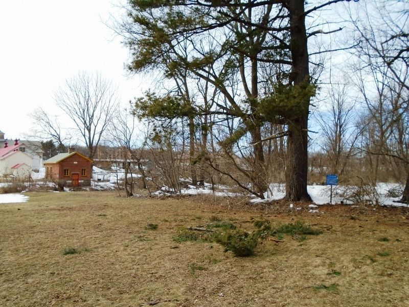
The Shakers stored milk in the creamery to keep it cool. Milk was brought from the barn in large milk cans, which were then kept cool in troughs filled by water diverted from the creek. Later the building was used as a hen house; now it is used . . . Map (db m115688) HM
5 New York, Albany County, Albany — Fort Van Nassau
On Smith Blvd, on the right when traveling south.
Built 1614 By The Dutch Explorers. Christiaensen And Block First Trading Center Established In New York State. Map (db m103295) HM
6 New York, Albany County, Albany — Ministry Shop (1825)
This brick building was used by the ministry elders. Each member of the ministry had to perform daily manual labor such as shoe making or tailoring. Elder Chauncey Copeley a cabinet maker, worked in a wing added to the building in 1850. . . . Map (db m115660) HM
7 New York, Albany County, Albany — Mother Ann Lee1736 - 1784
On Meeting House Road, on the left when traveling north.
First leader of the Shakers, a celibate Christian community. Their first settlement was in what is now Colonie.Map (db m115692) HM
8 New York, Albany County, Albany — Shaker Heritage Society GardenCome in.
The plants in this garden are some of the herbs used and sold by The Watervliet Shaker Community during the 1800's. The community grew large "Botanical/Physic" gardens and also gathered many wild herbs for use in their business of selling dried . . . Map (db m115658) HM
Paid Advertisement
9 New York, Albany County, Albany — Shaker Meeting House
On Meeting House Road, on the right when traveling north.
This Meeting House, or Church, was built in 1848 to replace an earlier (1791) and much smaller Meeting House. It demonstrates many typical characteristics of Shaker architecture; double doors, one for men and one for women; a large meeting room . . . Map (db m115663) HM
10 New York, Albany County, Albany — Sisters' Workshop (1840)
On this location was a large 3 1/2 sto[r]y stone building. Here Shaker Sisters did spinning, weaving, and sewing. Journal entries indicate that Sister Polly wove 3350 Shaker bonnets in this building. The building was the only stone building . . . Map (db m115656) HM
11 New York, Albany County, Albany — Wash House & Cannery (c.1858)
On Meeting House Road, on the left when traveling east.
Shaker Creek provided water for both the canning and laundry operations. The first laundry, done on December 12, 1859, used a steam powered washing machine. Albany County used the building for laundry until the mid 1980s. Today it is a workshop. . . . Map (db m115674) HM
12 New York, Albany County, Albany, Downtown — 1624-1924
On Eagle Street at Corning Place on Eagle Street.
In commemoration of the three hundredth anniversary of the founding in 1624 of the first permanent settlement of Albany, then known as Fort Orange, near the site of Fort Nassau built in 1614 and abandoned in 1617. With the establishment of . . . Map (db m64993) HM
13 New York, Albany County, Albany, Downtown — An English Neighborhood
On State Street at Lodge Street on State Street.
After the English gained control of the Hudson Valley from the Dutch in 1674, they established a strong presence in the town they renamed Albany. Soldiers headquartered at Fort Frederick just above this intersection. They formed a masonic lodge in . . . Map (db m76382) HM
14 New York, Albany County, Albany, Downtown — Building A Place to Live
On Broadway just north of State Street (New York State Route 5), on the right when traveling north.
Early Albany, the Dutch village of Beverwijck, was filled with artisans — the people who built the community and made it livable and bustling with activity. By the late 1650s, among the thousand residents who called Beverwijck home, hard . . . Map (db m144029) HM
15 New York, Albany County, Albany, Downtown — Fort OrangeBuilt in 1624
On Broadway (New York State Route 5) at Frontage Road, on the left when traveling south on Broadway.
Mere yards ahead of you once stood Fort Orange, the first permanent Dutch settlement in North America. The Dutch West India Company built Fort Orange at the most strategic crossroads in the region — at the head of the trail into Mohawk . . . Map (db m144034) HM
16 New York, Albany County, Albany, Downtown — Kilian Van Rensselaer
On Eagle Street at Corning Place, on the left when traveling north on Eagle Street.
Kilian Van Rensselaer the Progenitorof the Van Rensselaer family in America, a merchant of Amsterdam Holland, the original proprietor and first patroon of the Manor of Rensselaerwyck, under a grant from the Dutch government in 1629. In following . . . Map (db m116749) HM
17 New York, Albany County, Albany, Downtown — Lydius Corner
On State Street (New York State Route 5) at North Pearl Street, on the right when traveling west on State Street.
. . . Map (db m116731) HM
Paid Advertisement
18 New York, Albany County, Albany, Downtown — Site of First Poor House in the United States
On Broadway at Beaver Street, on the right when traveling south on Broadway.
On this site once stood the first Poor House in the United States. Community care for the poor was an important feature of Dutch society, and it took root here in Albany as the city was settled in the first half of the 1600s. . . . Map (db m116696) HM
19 New York, Albany County, Albany, Downtown — The Fur Trade
On Broadway at Maiden Lane, on the right when traveling north on Broadway.
Why is Albany Here? Mohawk and Mahican peoples inhabited this region for thousands of years when the Dutch ship the Half Moon dropped anchor near this spot in 1609. At that time, the world was in the midst of a "Little Ice . . . Map (db m116700) HM
20 New York, Albany County, Albany, Sheridan Hollow — Patroon Street
On North Pearl Street (New York State Route 32) 0.1 miles south of Clinton Avenue (U.S. 9), on the right when traveling south.
Former name of Clinton Ave. This was the dividing line between the City of Albany and the Manor of RensselaerwyckMap (db m116736) HM
21 New York, Albany County, Alcove — Paper Mills
On New York State Route 143 at County Route 111, on the left when traveling west on State Route 143.
1818 Ephraim Andrews acquires cloth dressing and wool carding mills. By 1850 John E. Andrews establishes a straw paper making millMap (db m131759) HM
22 New York, Albany County, Altamont — Altamont
On Main Street (New York State Route 146), on the right when traveling west.
Incorporated as a village 1890. Officers: President Hiram Griggs; Trustees Smith Philley, Jesse Crounse. Henry A. WilburMap (db m49530) HM
23 New York, Albany County, Altamont — Map — Altamont, New YorkThe Museum in the Streets
On Main Street (New York State Route 146) at Gun Club Road, on the right when traveling west on Main Street.
Welcome to Altamont The Village of Altamont and its immediate surroundings were once part of a tract of land deeded in 1630 by the Dutch West India Company to Killian Van Rensselaer (c. 1586-1643),a wealthy 17th century Dutch . . . Map (db m132693) HM
24 New York, Albany County, Altamont — Family Cemetery
On Brandle Road, 0.1 miles south of Main Street (New York State Route 146), on the left when traveling south.
Family Cemetery Of Early Pioneer Jurrian Severson Grave of John J. Vanaernam Ensign, Revolutionary War Born 1730 - Died 1814Map (db m44022) HM
25 New York, Albany County, Altamont — 11 — Fire Department / Village Hall / Cuerpo de Bomberos / AyuntamientoAltamont, New York — The Museum in the Streets —
On Maple Avenue (New York State Route 146) when traveling west.
The Altamont Hose Company No. 1 was organized in May 1893, with 25 citizens appointed as members by the Village Trustees. The Company's first location was rented space at the Temperance Hall on Lincoln Avenue. In 1926, the Company . . . Map (db m131453) HM
26 New York, Albany County, Altamont — 27 — KnowersvilleAltamont, New York — Museum In The Streets —
On Gun Club Road at Main Street (New York State Route 146), on the right when traveling north on Gun Club Road.
Few settlers ventured into the wilderness prior to the War of Independence. Roads were barely expanded trails between settlements. The Great Western Turnpike (now US Route 20) carried travelers west from Albany. Following ancient . . . Map (db m133581) HM
Paid Advertisement
27 New York, Albany County, Altamont — Severson House
On Main Street (New York State Route 146) at Brandle Road, on the right when traveling east on Main Street.
Built by Early Settler Jurrian Severson Located on Map of West Manor Rensselaerswyck, 1767 Map (db m44897) HM
28 New York, Albany County, Altamont — 16 — St. John’s Lutheran Church / Iglesia Luterna St. JohnAltamont, New York — The Museum in the Streets —
On Maple Avenue (New York State Route 146), on the right when traveling west.
St. John’s Lutheran Church, designed by Albany architect Charles Nichols and built by contractor George Rockefeller in 1871-72 was the first church built in Knowersville. The original church building was 42 x 62 feet and, completely . . . Map (db m131427) HM
29 New York, Albany County, Altamont — 5 — The Fredendall Funeral Home/La Funeraria FredendallAltamont, New York — The Museum in the Streets —
On Helderburg Street at Main Street (New York State Route 156), on the right when traveling west on Helderburg Street.
The Fredendall Funeral Home is the oldest continuously operated business in Altamont. In 1877, cabinet maker John Thierolf arrived in the village from Albany and soon established a thriving furniture business. Wood crafters were often . . . Map (db m145181) HM
30 New York, Albany County, Altamont — 4 — Wayside Inn / Posada WaysideAltamont, New York — The Museum in the Streets —
On Main Street (New York State Route 156) at Altamont Boulevard (New York State Route 156), on the left when traveling north on Main Street.
George Severson (1766-1813), a grandson of Jurrian Severson, one of the area's first settlers, built the Wayside Inn ca. 1785 along the wagon track that is now Main Street. The site of the Inn was approximately half way between the . . . Map (db m145191) HM
31 New York, Albany County, Berne — 347 — Anti-Rent
On Helderberge Trail (New York State Route 443), on the right when traveling west.
Convention Held Here January 15, 1845. Delegates From 11 Counties Petitioned State To End Unjust Land Lease System. Map (db m131413) HM
32 New York, Albany County, Berne — Earliest House
On Tabor Road at Lendrum Road, on the right when traveling south on Tabor Road.
Built About 1750 By Peter Weidman, A Swiss, Stood On This Site Map (db m101715) HM
33 New York, Albany County, Berne — East Berne
On Main Street near Helderberg Trail (New York State Route 443), on the right when traveling south.
Formerly Called Werner's Mills And Philadelphia Map (db m50538) HM
34 New York, Albany County, Berne — Pioneer
On Berne-Altamont Road (New York State Route 156) at Stranahan Lane, on the right when traveling south on Berne-Altamont Road.
Col. Jesse Wood of Long Island settled here about 1800. Served in War of 1812. Died July 23, 1853 at age of 83 YearsMap (db m101719) HM
35 New York, Albany County, Berne — Reformed Dutch Church
On Helderburg Trail (New York State Route 443), on the right when traveling east.
Organized 1763. First Pastor Johannes Schuyler 1767. Oldest Church in County outside of Albany Map (db m50191) HM
Paid Advertisement
36 New York, Albany County, Berne — Weidman Home
On Helderberg Trail, on the right when traveling east.
The Largest House in Berne With Ten Fireplaces Built By Peter Weidman In 1800, Stood On This Site Map (db m101717) HM
37 New York, Albany County, Berne — West Berne
On New York State Route 443 near Dutch Settlement Road (County Route 9), on the right when traveling east.
West Berne Called Mechanicsville 1830-34 Because So Many Mechanics Lived Here Map (db m73433) HM
38 New York, Albany County, Clarksville — Harmanus Bogardus House / Blacksmith Shop
On Delaware Turnpike (New York State Route 443) 0.1 miles west of Tarrytown Road, on the left when traveling west.
( east face ) Site of Harmanus Bogardus House Built by Bogardus c.1803. Adam A. Clark House 1822-1838. John Crookes House 1864-1868. Morgan E. Barber House 1882-1918. Burned in Great Fire of 1918. ( west face . . . Map (db m142472) HM
39 New York, Albany County, Clarksville — Houghtaling House
On County Route 312, on the right when traveling south.
Built before 1770 by Teunis Houghtaling, born May 18, 1740 - died May 20, 1806. Listed on National Register June 28, 2004.Map (db m135121) HM
40 New York, Albany County, Clarksville — Meed House
On Delaware Turnpike (New York State Route 443) at Tarrytown Road, on the left when traveling east on Delaware Turnpike.
Built about 1810 by Harmanus Bogardus for Henry L. Meed, first postmaster of Bethlehem P.O. from 1812-1826. P.O. was here. Bethlehem supervisor 1821-1822Map (db m142469) HM
41 New York, Albany County, Coeymans — Coeymans
On Main Street (New York State Route 143) at Westerlo Street, in the median on Main Street.
Town formed March 18, 1791 from Watervliet. A part went to form Westerlo in 1815. Named from the patentee Barent Pieterson CoeymansMap (db m135122) HM
42 New York, Albany County, Coeymans Hollow — 1780 Shear Farm
On New York State Route 143, on the left when traveling west.
Built by Israel Shear. Restored 1980 by Paul & Nancy Caswell. Placed on State Register of Historic Places October 9, 1996. National Register Dec. 6, 1996Map (db m131672) HM
43 New York, Albany County, Cohoes — Fonda Cemetery
On Loudon Road (U.S. 9), on the left when traveling north.
Early Settlers at Boght and Crescent. Intermarried with Lansing's. Organized the Boght Reformed Church in 1784. Fonda Rd. is named for the family.Map (db m129626) HM
44 New York, Albany County, Cohoes — James “Buttermilk” Lansing
On Columbia Street (New York State Route 470) at Sunset Court, on the right when traveling west on Columbia Street.
Home of James "Buttermilk” Lansing Built by Douw Fonda before 1767. One of founders of Boght Settlement, Cohoes, N.Y.Map (db m147936) HM
Paid Advertisement
45 New York, Albany County, Cohoes — Native American & 17th-century History of Peebles Island
On Delaware Avenue, on the left when traveling north.
There is abundant evidence of Indian occupation on Peebles and Van Schaick Islands. Hammerstones and projectile points have been discovered and suggest that early tribes lived in this area. Archeologists uncovered a number of early hearths here . . . Map (db m115382) HM
46 New York, Albany County, Cohoes — View of Van Schaick Island
On Delaware Avenue, on the left when traveling north.
You are looking at the northern tip of Van Schaick Island. The Hudson River flows to the east, and the third and fourth branches of the Mohawk River flow around the rest of this rocky island. Dutch merchants Philip Pietersen Schuyler and Goosen . . . Map (db m115371) HM
47 New York, Albany County, Colonie — Schuyler Flatts
On Broadway (New York State Route 32) at Earl Dr. (Private), on the right when traveling north on Broadway.
Farm of Arendt Van Curler 1643-1667. Pieter Schuyler & Margarita Schuyler after 1672. Fortified 1747, and Military Encampment 1750's Map (db m184813) HM
48 New York, Albany County, Colonie — Shaker Church Family Barn
On Heritage Lane (County Route 151) at Meeting House Road, on the right when traveling north on Heritage Lane.
Built in 1916 on the site of the original barn which had been destroyed by fireMap (db m40593) HM
49 New York, Albany County, Colonie — The Boght
On Boght Road (New York State Route 9R), on the right when traveling west.
The Boght Settled On and After 1704 By The Vischer Weaver Witbeck Lansing Powell Runkle Dunsbach Lieverse Staats Roff Godfrey Van O Linde Groesbeck Van Vranken Fero Van De Mark Van Denburgh Johnson Pollock Storms Fonda and . . . Map (db m24731) HM
50 New York, Albany County, Delmar — Delmar
On Delaware Ave. (New York State Route 443) at Adams Street, on the right when traveling west on Delaware Ave..
Earlier Adamsville And Adams Station Nathaniel Adams Located Here In 1836 and Built A Hotel in 1838 Map (db m97281) HM
51 New York, Albany County, Dormansville — Dormansville
On County Route 312 at New York State Route 143, in the median on County Route 312.
Named in honor of Daniel Dorman, an inn and store keeper, and first postmaster in 1832Map (db m135109) HM
52 New York, Albany County, Elsmere — Connecting People With CommunitiesThe Elsmere Train Station
Near Elsmere Ave.
The Elsmere Train Station The hamlet of Elsmere represents the influence which railroads had on the growth of suburban communities. In 1863, when the first A&S Railroad train left Adams Station for Albany, the area now known as Elsmere . . . Map (db m185915) HM
53 New York, Albany County, Ferura Bush — Slingerland-Lagrange Farm
On LaGrange Lane, 0.1 miles north of Indian Fields Road (State Highway 32), on the right when traveling north.
Slingerland- Lagrange Farm Family Owned 12 Generations. Stone House Built c.1750's. Home of Revolutionary War Soldier Albert Slingerland.Map (db m140968) HM
Paid Advertisement
54 New York, Albany County, Feura Bush — Slingerland House 1762
On Indian Fields Road (New York State Route 32), on the left when traveling south.
Built by Tunis Cornelise Slingerland, Dutch emigrant 1650, on land purchased from IndiansMap (db m130530) HM
55 New York, Albany County, Fullers — Abraham Wemple
On Western Avenue (U.S. 20) 1 mile west of Fuller Station Road, on the right when traveling east.
Col. Schenectady militia during American Revolution owned farm here 1765 to death in 1799. Buried on high knoll above reservoir.Map (db m144957) HM
56 New York, Albany County, Guilderland — Farm of Evert Bancker
On New York State Route 146 just west of Christopher Lane, on the right when traveling west.
Third Mayor of Albany, 1695 Indian Commissioner, 1696 Master Chancery, 1705 Died Here, 1734 Map (db m50126) HM
57 New York, Albany County, Guilderland — Frederick Crounse
On Altamont-Voorheesville Road (New York State Route 156) near Brandle Road, on the right when traveling south.
Farm of Frederick Crounse Officer 3D Albany Co. Militia in Revolution. Carried food to Army Battle of Saratoga. Buried Here Map (db m48377) HM
58 New York, Albany County, Guilderland — Guilderland Town Hall
On Western Turnpike (U.S. 20), on the right when traveling west.
Town Hall Town of Guilderland Est. April 4, 1803 First Officers; Supervisor Nicholas V. Mynderse, Clerk Peter G. Veeder Town of Guilderland 1985 Map (db m103165) HM
59 New York, Albany County, Guilderland — Inn of Jacob Crounse
On New York State Route 146, on the right when traveling west.
Built 1833. Midway tavern where horses were changed on Schoharie-Albany Stage Coach Route Map (db m49512) HM
60 New York, Albany County, Guilderland — Knower House
On New York State Route 146, on the right when traveling west.
Est. as hat factory about 1800 by Benjamin Knower Gov. William L. Marcy Married Cornelia Knower in this house Map (db m49446) HM
61 New York, Albany County, Guilderland — Palatine Road
On New York State Route 146 near Wagner Road, on the right when traveling east.
c. 1712 First Road West By German Refugees To Schoharie Valley Map (db m49555) HM
62 New York, Albany County, Guilderland — Wildehausen
On Dunnsville Road, on the right when traveling south.
Site of an Indian Village Nearby Stream Called Wildehausekill or "Indian House Creek" Map (db m66751) HM
Paid Advertisement
63 New York, Albany County, Guilderland Center — Freeman House
On Main Street (New York State Route 146), on the right when traveling east.
Said to have been erected 1734 later the home of Barent Mynderse, Lieut. in War of Revolution Map (db m49721) HM
64 New York, Albany County, Guilderland Center — House Built 1802
On Main Street (New York State Route 146), on the right when traveling west.
By Nicholas V. Mynderse sold to Michael Frederick who ran it as a tavern for many years Map (db m49720) HM
65 New York, Albany County, Knox — Knieskem Farm
On Cross Road, on the right.
Settled by Hendrick Knieskem about 1750 Map (db m54208) HM
66 New York, Albany County, Knox — 227 — Palatine Trail
On Knox-Gallupville Road (County Route 255), on the right when traveling west.
Road Used For Travel West to Schoharie Valley. As Early as 1767, the Town of Knox Began To Grow Around This Path.
Map (db m223348) HM
67 New York, Albany County, Knox — Sand Farm
On Berne-Altamont Road (New York State Route 156) at Farm Lane, on the right when traveling south on Berne-Altamont Road.
Sand Farm Settled by Christian Zandt in 1787 Map (db m57937) HM
68 New York, Albany County, Knox — Town of Knox
On Berne-Altamont Road (New York State Route 156) near Town Hall Road, on the right when traveling west.
Established Feb. 22, 1822 Formed from Town of Berne Pillbox capital 1806-1906 First Town Supervisor was Malachi Whipple Map (db m49450) HM
69 New York, Albany County, Knox — Whipple Farm
On Berne-Altamont Road (New York State Route 156), on the right when traveling west.
Settled by Malachi Whipple of Conn. about 1793. In 1820 farm won premium as model farm in Albany County Map (db m49447) HM
70 New York, Albany County, Latham — Latham
On Old Loudon Road, on the right when traveling south.
. . . Map (db m75495) HM
71 New York, Albany County, Loudonville — Historic Loudonville
On Old Niskayuna Road at Osborne Road (New York State Route 378), on the right when traveling north on Old Niskayuna Road.
Once called Ireland's Corners. Named in 1871 for Gen. John Campbell, 4th Earl of Loudoun. Commander of His Majesty's forces - French & Indian WarsMap (db m142982) HM
Paid Advertisement
72 New York, Albany County, Loudonville — Loudonville
On New Loudon Road (U.S. 9) at Menands Road (New York State Route 378), on the right when traveling north on New Loudon Road.
Settled ca. 1800. Part of Van Rensselaer Manor. Many historic homes listed on State and National RegistersMap (db m142467) HM
73 New York, Albany County, New Salem — Rev. Harmanus Van Huysen Home
On New Scotland Road (New York State Route 85) at Helderhill Road, on the left when traveling west on New Scotland Road.
Original part built c. 1816. revolutionary War Captain. Served 3 area churches from 1794-1825. His descendants lived in home until 1922.Map (db m136073) HM
74 New York, Albany County, New Scotland — Hotaling / Pound House
On Bullock Road south of New Scotland Road (New York State Route 85), on the left when traveling south.
Built by Capt. Thomas Rogers c.1820. Home of Aaron Hotaling. owned for over 50 years by the family of Arthur Pound, state historian, poet & author.Map (db m142764) HM
75 New York, Albany County, New Scotland — 280 — Lime Kiln Farm
On Clipp Road, on the right when traveling south.
Named for Stone Kilns used to make lime. First farmed 1842. Miller Family farmed here over 100 years beginning in 1905. Map (db m97287) HM
76 New York, Albany County, Preston-Potter Hollow, Preston Hollow — Dr. Samuel Preston
On New York State Route 145, on the left when traveling south.
Settled here in 1789 and gave his name to Preston Hollow. He built the first sawmill and gristmillMap (db m131419) HM
77 New York, Albany County, Rensselaerville — Hamlet of Rensselaerville
On Delaware Turnpike (County Route 353) at NY 85 & Albany Co. 351, on the right when traveling east on Delaware Turnpike.
Settled in 1787. Historic District on the National and New York State Registers of Historic PlacesMap (db m136109) HM
78 New York, Albany County, Rensselaerville — Hans Winegar
On New York State Route 85 at County Route 351, on the left when traveling south on State Route 85.
From Stockbridge, Mass. second settler in the village built a log home on the site of the village in 1788Map (db m136114) HM
79 New York, Albany County, Rensselaerville — Samuel JenkinsThe Father of Rensselaerville
On County Route 351 near Albany Hill Road (County Route 361), on the right when traveling east.
Known as Jenkin's Mills 1795-1896. First visited site in 1787, located 1788, built house and grist mill 1789. Died 1837Map (db m136126) HM
80 New York, Albany County, Selkirk — Bethlehem's Historic WaterfrontWelcome to Moh-He-Con-Nuck Nature Preserve
On River Road (New York State Route 144) 0.1 miles south of Simmons Road, on the right when traveling north.
The Mohican Indians and their ancestors lived in this area along the Hudson. River where the ocean tides flowed. The name Moh-He-Con-Nuck means "People of the Waters That Are Never Still" The Grandfather by artist Len Tantillo, is set in . . . Map (db m230106) HM
Paid Advertisement
81 New York, Albany County, Selkirk — Hamlet of Selkirk
On New York State Route 396 at Cottage Lane, on the left when traveling west on State Route 396.
Named for James Selkirk 1757-1820. 2nd Regiment-Line, American Revolution. Native of Scotland settled here in 1786Map (db m129515) HM
82 New York, Albany County, Selkirk — Wiltsie Farm
On New York State Route 396, on the left when traveling west.
Wm. Wiltsie of Nobletown, Columbia County and member of the Dutchess County Militia settled on this property in 1795.Map (db m129514) HM
83 New York, Albany County, Slingerlands — LaGrange Farm
On Vista Boulevard west of New York State Route 85 when traveling west.
1686 Omie de LaGrange settles 1716 owned 69,000 acres family farms here until 1954 Buried Christian & Jamima LaGrange and sonsMap (db m244484) HM
84 New York, Albany County, Slingerlands — New Scotland
On New Scotland Road (New York State Route 85) at S Road, on the left when traveling east on New Scotland Road.
New Scotland Town formed April 25, 1832 from Bethlehem. First town meeting held at home of Edmund Raynsford April 9, 1833.Map (db m140963) HM
85 New York, Albany County, Slingerlands — Slingerland Home
On New Scotland Road (New York State Route 85) east of Font Grove Road (County Route 306), on the left when traveling east.
Rear portion built 1790 by John A. Slingerland Front additions after 1845 by John I. Slingerland Sold out of family 1953Map (db m244574) HM
86 New York, Albany County, Voorheesville — Connecting People With CommunitiesThe Voorheesville Train Station
On Grove Street at South Main Street, on the right when traveling east on Grove Street.
Fields of Indian Corn and Potatoes The surrounding landscape was very different on September 15, 1863, when the first Albany and Susquehanna train rolled through from Albany to Central Bridge. Passengers saw only farm fields of Indian corn . . . Map (db m185911) HM
87 New York, Albany County, Voorheesville — Voorhees House
On Prospect Street, on the right when traveling east.
Built By Alonzo B. Voorhees Ca. 1867; Elegant Summer Boarding House of S.V.R. & Mahula Hoes Ca. 1879 - 1893 Map (db m146850) HM
88 New York, Albany County, Watervliet — City of Watervliet
On Broadway at 15th Street, on the right when traveling south on Broadway.
The land now occupied by the City of Watervliet is part of a tract purchased by the first Patroon, Kiliaen van Rensselaer in 1630 from the Mohican or River Indians. The tract was within a large area on the west side of the Hudson River named Wely's . . . Map (db m58228) HM
89 New York, Albany County, West Berne — Beaver Dam
On Helderberg Trail (New York State Route 443) 0.1 miles east of County Route 254, on the left when traveling east.
Later called Bernville. Fortified during the revolution. John Dietz' family massacred by IndiansMap (db m158188) HM
90 New York, Albany County, West Berne — Dwelling
On New York State Route 443, on the left when traveling west.
Built about 1800 by William ShultesMap (db m132599) HM
91 New York, Albany County, Westerlo — Allen House
On Bear Swamp Road (County Route 404) at Lockwood Road, on the right when traveling east on Bear Swamp Road.
Built 1795, here and on this road lived Ebeneazer Allen and his sons Justice, Howard, and Stephen. All soldiers in RevolutionMap (db m136127) HM
92 New York, Albany County, Westerlo — Anti-Rent War
On Delaware Turnpike (New York State Route 85) at Switzkill Road (County Route 1), on the right when traveling west on Delaware Turnpike.
Events in the quarrel of tenants with Lord of the Van Rensselaer Manor occurred in this region in 1840 and later Map (db m50490) HM
93 New York, Albany County, Westerlo — Beardsley House
On Switzkill Road (County Route 1), on the left when traveling west.
Home of William Beardsley. Here was held first town meeting of Westerlo, April 4, 1815.Map (db m135143) HM
94 New York, Albany County, Westerlo — Early Doctor
On New York State Route 32, on the right when traveling south.
Dr. Jonathan Prosser of Dutchess County settled on this farm in 1788Map (db m129504) HM
95 New York, Albany County, Westerlo — Myers Farm
On Myers Road (County Route 401), on the right.
Philip Myers of Germany in 1763 built a log house at Chesterville, married a daughter of Nicholas Stoddard and died 1813Map (db m135149) HM
96 New York, Albany County, Westerlo — South Westerlo
On County Route 405, 0.1 miles south of Creamery Road, on the right when traveling north.
Name changed in 1827 from Smith's Mills named after David Smith who also owned a tannery and ashery.Map (db m158183) HM
97 New York, Albany County, Westerlo — Westerlo
On New York State Route 143, on the left when traveling west.
Town formed March 16, 1815 from Coeymans and Rensselaerville. Named for Rev. Eilardus Westerlo of Albany.Map (db m135147) HM
98 New York, Allegany County, Angelica — The Town of Angelica
On Park Circle at East Main Street (County Road 16), on the right when traveling east on Park Circle.
Founded 1805 by Judge Phillip Church; named for his mother Angelica Schuyler Church, a sister-in-law of Alexander Hamilton. Judge Church designed the Park Circle with public buildings on the perimeter and the Town Park in the center. Angelica . . . Map (db m159374) HM
99 New York, Allegany County, Canaseraga — First House in Canaseraga
On Mill Street (County Route 13B) 0.1 miles south of River Street, on the left when traveling north.
Built on this site by Samuel Boylan in 1806.Map (db m75911) HM
100 New York, Allegany County, Scio — Town of Scio
On Main Street (New York State Route 19) 0.1 miles north of Vandermark Road (County Road 10), on the right when traveling north.
The area around Scio was first settled around 1805 by Joseph Knight, a minuteman in the American Revolution. Knights Creek, which flows into the Genesee River near Scio, is named for him. Before getting its final name, Scio was called Bloods Corner . . . Map (db m175123) HM

2072 entries matched your criteria. The first 100 are listed above. Next 100 ⊳
 
 
CeraNet Cloud Computing sponsors the Historical Marker Database.
This website earns income from purchases you make after using our links to Amazon.com. We appreciate your support.
Paid Advertisement
Apr. 24, 2024