Near St. George Street close to St. Anthony Street, on the left when traveling west.
English
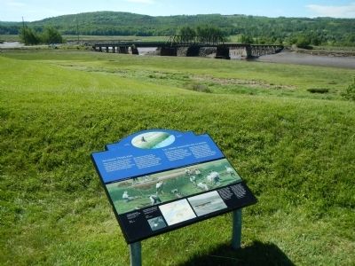
When the French settled at Port-Royal in the early 1600s, the shores of the Annapolis River were bordered with tidal salt marsh. In the 1630s, the French at Port-Royal started reclaiming this fertile land by building dykes.
The . . . — — Map (db m78488) HM
On St. George Street close to St. James Street, on the left when traveling north.
English
From its strategic setting, Annapolis Royal has witnessed pivotal events in the history of European settlement in Canada. Located on a former Mi’kmaq meeting place, the townsite and its environs were known as Port-Royal by the . . . — — Map (db m78670) HM
Near St. George Street close to St. Anthony Street, on the left when traveling west.
Two markers are located on these monument. Charles Fort / Le fort Charles English
A group of about 70 Scottish settlers began a colony here in 1629, eight years after King James I granted ‘Nova Scotia’ to Sir William . . . — — Map (db m78486) HM
On St. George Street close to St. Anthony Street, on the left when traveling west.
English
Before you, the Allain and Annapolis rivers meet, creating a stopping place used by travelers for many centuries. The Annapolis River makes access to the site easy, while the natural rise of land provides a good view downstream. . . . — — Map (db m78483) HM
Near St. George Street close to St. Anthony Street, on the left when traveling west.
English
A French Huguenot in the British army, Mascarene served here from 1710 to 1750. He was a member of the Council of Nova Scotia (1720-50), lieutenant-colonel of Philipps’ Regiment (1742-50), and administrator and commander in chief . . . — — Map (db m78491) HM
Near St. George Street close to St. Anthony Street, on the left when traveling west.
English
When the French first came to the Annapolis Basin, Samuel de Champlain called it “Port-Royal” in recognition of its great size.
Eventually, the area surrounding the basin and along the Annapolis River became known as . . . — — Map (db m78449) HM
Near St. George Street close to St. Anthony Street, on the left.
To the illustrious memory of Lieut. Gen’l Timothé Pierre du Guast,
Sieur de Monts,
the pioneer of civilization in North America, who discovered and explored the adjacent river, A.D. 1604, and founded on its banks the first settlement of . . . — — Map (db m78443) HM
On Esplanade at Amelia Street, on the left when traveling north on Esplanade.
[English] On 3 August 1802, the 245 ton ship, “Northern Friends,” arrived in Sydney Harbour with 415 settlers from Scotland. This marked the first emigration directly from Scotland to Cape Breton and formed the vanguard of the . . . — — Map (db m169199) HM
On Esplanade north of York Street, on the left when traveling north.
English:
A distinguished military engineer, of Huguenot descent, Desbarres served in the British Army in North America during the Seven Years’ War, and participated in the capture of Louisbourg in 1758 and of Quebec in 1759. From . . . — — Map (db m140081) HM
Near Esplanade at Dorchester Street, on the right when traveling north.
Come and explore the Colonial Town of Old Sydney. Few cities in North America can boast eight buildings erected between 1785 and 1802 within a two-block radius. In season, we invite you to visit these historic buildings: St. Patrick's Church Museum . . . — — Map (db m171099) HM
On Victoria Road (Route 28) south of Church Street, on the right when traveling north.
English:
In the late 19th and early 20th centuries, thousands of immigrants came to Cape Breton from Europe, the West Indies, the United States, and elsewhere to work in iron and steel production. Many settled in Whitney Pier, . . . — — Map (db m139295) HM
You can see where some of the rock
has been removed to make a millstone
Located at Kennedy Hill, Central New Annan
Donated by Mr. William Woodlock — — Map (db m108169) HM
On Sunrise Trail (Nova Scotia Route 6) just west of Nova Scotia Route 326, on the left when traveling east.
Within this iron fence lies
Duncan MacLanders
1788 - 1870
and
Johanne Faulkner
1788 - 1876
First of the line to leave the
shores of Scotland and seek a freer
and fuller life in the New World.
Erected by descendants in . . . — — Map (db m108165) HM
On Tidal Bore Road, 0.6 kilometers north of Glooscap Trail (Nova Scotia Route 236), on the left when traveling north.
In 1760-62 near this Head of Cobequid Bay the first English speaking settlers of the Townships of Onslow and Truro landed. Of Ulster Irish, Scottish and English stock, these pioneers were among those brought to Nova Scotia from New England by the . . . — — Map (db m108717) HM
On Prince Street just east of Lorne Street, on the left when traveling east.
Legend
This plaque commemorates
The centennial of the formation of the Presbyterian Church in Canada in 1875;
The ministry of the Rev. Daniel Cock (1771-1805) of Greenock, Scotland, and the Rev. David Smith (1771-1795) of St. Andrew's, . . . — — Map (db m108220) HM
On Prince Street just east of Louise Street, on the right when traveling east.
The Lumber Jack represents the exciting role Truro has played in development of forestry in Nova Scotia. Truro has always been, and still is today, a centre of forestry activity. The forest industry continues to be the backbone of the local and . . . — — Map (db m108243) HM
[Face]
The Acadian village of Beaubassin on this site was founded by settlers from Port Royal around 1672. Upon the arrival of Major Charles Lawrence with British troops in April 1750, the French authorities had the village destroyed in . . . — — Map (db m106953) HM
This area was the site of the Acadian village of Beaubassin, first known Bourgeois settlement. Raided in 1696 and again in 1703 by a force from Boston under Captain Ben Church. Occupied by French troops in 1746 who travelled on snowshoes in . . . — — Map (db m106951) HM
The First Nations
Native peoples have lived around the Chignecto Isthmus for thousands of years. Travelling in family groups and small nomadic bands, they moved from area to area harvesting seasonal food sources.
Early French explorers were . . . — — Map (db m112112) HM
Fondateur, vers 1672, de Beaubassin premier établissement dans la région de la rivière Missagouèche et initiateur de l'agriculture maraîchère en Acadie
Jacob Bourgeois arriva à Port-Royal en 1641 à titre de chirurgien pour la colonie . . . — — Map (db m107012) HM
On Durham Street at Water Street, on the left when traveling west on Durham Street.
Pugwash sits on top the largest salt deposit in Atlantic Canada. The train tracks, bridges, and wharves that defined the tapestry of the village infrastructure changed significantly over the decades as local industry evolved, including the . . . — — Map (db m108068) HM
On Water Street just north of Victoria Street, on the right when traveling north.
Historically, the main streets were lined with hotels, merchants, and services one would expect of a long-standing port village. The village endured seven devastating fires between 1877 to 1929 that permanently changed the street-scape . . . — — Map (db m108083) HM
On Water Street at Victoria Street, on the right when traveling north on Water Street.
All of the community celebrations culminate on Water Street. Canada Day has been celebrated in Pugwash since 1951 with festivities called "The Gathering of the Clans" paying homage to some of its founding settlers. This is also the reason many of . . . — — Map (db m108076) HM
On School Street, on the right when traveling east.
Important as a centre for the North Atlantic fisheries from
the 16th century, the islands in Canso Harbour offered a
safe haven for fishermen. First frequented by the French
and Basques, the area became the site of an extensive . . . — — Map (db m138598) HM
During the seventeenth century French fishermen came from Cape Breton, across Chedabucto Bay, to fish for cod in thirty foot shallops. Later, the New England colonists came in their schooners. They fished the Banks and dried their fish . . . — — Map (db m140536) HM
This is a place where seafaring people found shelter from the
harshness of the Northwest Atlantic. It is the most easterly point of mainland Nova Scotia, remote
and exposed upon Chedabucto peninsula, yet close to the fishing banks so . . . — — Map (db m140505) HM
On Church Street (Nova Scotia Route 16) at Queen Street, on the left when traveling north on Church Street.
The Court House was constructed in 1842-43. It was the third court house built in Guysborough, the original administrative centre of Sydney County from 1785-1827. Sydney County included present-day Guysborough and Antigonish Counties.
Built in . . . — — Map (db m139264) HM
On Marine Drive (Nova Scotia Route 316) at Ballfield Loop, on the right when traveling west on Marine Drive.
The first settlers of Port Royal must have been aware of the extraordinary fertility of the immense salt marshes that surrounded them The height of the wild grasses alone would have been a clear sign of very productive soil. Until the . . . — — Map (db m141244) HM
On Marine Drive (Nova Scotia Route 316) at Ballfield Loop, on the right when traveling west on Marine Drive.
Many of the Acadians who escaped, or survived the Great Upheaval of 1755 to 1763, either died of exposure, or were captured and imprisoned as "Prisoners of War". Makeshift detention centers were often old trading posts such as Fort Edward . . . — — Map (db m141399) HM
On Marine Drive (Nova Scotia Route 316) at Ballfield Loop, on the right when traveling west on Marine Drive.
This monument is the creation of Raymond Delorey of Larrys River and the idea was conceived by members of "la Société des Acadiens de la Région de Tor Baie” under the direction of its Executive, President, Jude Avery, Vice President, . . . — — Map (db m141175) HM
On Marine Drive (Nova Scotia Route 316) at Ballfield Loop, on the right when traveling west on Marine Drive.
In 1603, Henry IV, King of France, granted Pierre Dugas, Sieur de Monts, the right to colonize lands in North America between the 40th and 60th degree north latitude. Along with the right to colonize that extensive region, his company was . . . — — Map (db m141181) HM
On Marine Drive (Nova Scotia Route 316) at Ballfield Loop, on the right when traveling west on Marine Drive.
Grand Pré (large meadow) settlement began in 1682 when a few families from Port Royal moved there. It is situated near the shores of Minas Basin, an inlet that empties into the Bay of Fundy. By 1707, the population had grown to 580 . . . — — Map (db m141256) HM
On Marine Drive (Nova Scotia Route 316) at Ballfield Loop, on the right when traveling west on Marine Drive.
Welcome to our Commemorative Park!
This development is a direct result of a cultural awakening following local festivities in 2004, in conjunction with the World Congress of Acadians, which was celebrated throughout Nova Scotia. Our people . . . — — Map (db m141146) HM
On Marine Drive (Nova Scotia Route 316) at Ballfield Loop, on the right when traveling west on Marine Drive.
Arriving in 1604, the French settlers built a fort on a small island named Ile Ste Croix at the mouth of the Ste. Croix River, which separates present day New Brunswick and Maine. After a disastrous winter, where 35 of the 79 men died of . . . — — Map (db m141190) HM
On Marine Drive (Nova Scotia Route 316) at Ballfield Loop, on the right when traveling west on Marine Drive.
After many visits to this eastern coastline region of mainland Nova Scotia between the years 1763 and 1797, a determined group of Acadian families from Chezzetcook, who were once again searching for peace and freedom, decided that the . . . — — Map (db m141401) HM
On Marine Drive (Nova Scotia Route 316) at Ballfield Loop on Marine Drive.
With the founding of Halifax in 1749 as a British naval base, the Acadians became the target of concern and possible displacement. Demands on them to accept and sign an "oath of allegiance” to the British crown were made several . . . — — Map (db m141258) HM
On Marine Drive (Nova Scotia Route 316) at Ballfield Loop, on the right when traveling west on Marine Drive.
The Deportation began in 1755 and ended with the signing of the Treaty of Paris in 1763. This Treaty not only ended what was perhaps the greatest human atrocity committed in British North America but it also gave Acadians the right to . . . — — Map (db m141389) HM
On Marine Drive (Nova Scotia Route 316) at Ballfield Loop, on the right when traveling west on Marine Drive.
Over the next eight years, or until the signing of the Treaty of Paris in 1763, the Great Upheaval continued in what has become known as the first act of "ethnic cleansing” in North America. In an ill-conceived and desperate plan . . . — — Map (db m141274) HM
On Marine Drive (Nova Scotia Route 16), on the left when traveling east.
Early European Settlers
The first European settlers of Queensport -- then known as Crow Harbour – bore family names of Digdon, Lamb, Lindsay, Sherlock, and Smith. The latter two families established a large fishing enterprise in the . . . — — Map (db m140674) HM
On Marine Drive (Nova Scotia Route 16), on the left when traveling east.
A Community linked to the Sea
Queensport was a fishing village community long before the first European settlers arrived here in the 1700s. Each spring and summer, the aboriginal Mi’kmaq would gather to harvest fish, one of the most . . . — — Map (db m141232) HM
Near Whitehead Road, on the right when traveling south.
Folklore of Whitehead
In April of about 1880, a brig sailed into Whitehead Harbour, claiming to be headed to Greenland whaling. Strangely, it had no name, and no one was allowed aboard or ashore. They stayed in harbor about a week. . . . — — Map (db m140380) HM
Near Whitehead Road, on the right when traveling south.
Village of Port Felix/Molasses Harbour
Early Acadians called Port Felix Molasses Harbour because of a keg of molasses washing up on shore. Many Acadian settlers arrived about 1797 after
the fall of Louisbourg. Following the American . . . — — Map (db m140390) HM
On Whitehead Road, on the left when traveling south.
Early names of the community were Martingot and Tete Blanche.
Lovell's 1871 Directory of Nova Scotia said "Whitehaven is a fishing settlement intended to be the terminus of the inter-colonial railway. The harbour is one of the finest on the . . . — — Map (db m140352) HM
On Whitehead Road, on the left when traveling south.
Many yards in Whitehead boast a lilac bush which originated from the lilac bushes in Yankee Cove
Kayak/boating enthusiasts love the scenic voyage through "The Runs” via Yankee Cove & The Basin.
1760 – Seasonal fishermen began . . . — — Map (db m140377) HM
Canal Camp
You are looking at a part of the remains of what was known as the “Canal Camp.” The row of stones in this area represent the largest feature found to day at Port Wallace. An archeological investigation was carried out . . . — — Map (db m77987) HM
In August 1750, the 504 ton ship Alderney arrived after a month's sail from England with 353 settlers, who made their first landing near the sawmill site. They laid out 184 building lots, 50 feet by 100, and named the settlement after the . . . — — Map (db m113104) HM
On George Street at Upper/Lower Water Street, on the right when traveling east on George Street.
Dedicated to the original Irish
settlers of 1749 and to the
contributions of the Irish
community to Halifax, to
Nova Scotia and to Canada
Tíolactha do na hÉireannaigh a
bhain fúthu í Halifax sa bhliain
1749 is mar aitheantas da . . . — — Map (db m113130) HM
On Hollis Street close to Morris Street, on the left when traveling south.
Charles Morris was Nova Scotia’s Chief Surveyor and one of he first residents of Halifax.
In 1750, on order from the founder of Halifax, Edward Cornwallis, Morris began surveying the entire peninsula, laying out new suburbs and 240 acres of . . . — — Map (db m77647) HM
France and Canada share a long history. Theirs is a story of enduring friendship.
It began 400 years ago, in Nova Scotia, the birthplace of Acadie, with the arrival of the first French settlers and of Samuel de Champlain at Port-Royal in 1605. . . . — — Map (db m77622) HM
On George Street at the Waterfront, in the median on George Street.
Just inland from this place, Chebucto Landing, 2,576 first permanent settlers of Halifax came ashore from thirteen small ships in June 1749. Here, you are at the shore of one of the great natural harbours of the world, the focus of Halifax's . . . — — Map (db m113185) HM
This monument is a universal symbol of a proud, strong and globally united Lebanese
community. The statue honours the early Lebanese settlers who, 130 years ago,
established a presence in this country, sewing the bonds of loyalty, faith, . . . — — Map (db m139674) HM
English
Celebrating Canada’s Immigrants
In the 1940s and 1950s, Canada opened its doors wide to European immigrants. With haunting wartime memories still fresh in their minds, men, women and children from diverse countries and . . . — — Map (db m77876) HM
English
When the Canadian immigration complex known as Pier 21 closed its doors in March of 1971, it marked the end of a more than forty-year saga of human hope, vision, courage and resilience. From its opening on the Halifax waterfront in . . . — — Map (db m77616) HM
There are three plaques on this monument.
Pier 21 / Le Quai 21 English
This site witnessed the arrival of approximately one million immigrants, who have enriched the cultural mosaic of Canada. Opened in 1928, Pier 21 served . . . — — Map (db m77718) HM
This monument/marker is made up of four panels, two in English and two in French. Each language has a panel dealing with The Grand Dérangement and Georges Island. On top is a large, round medallion featuring a map showing Acadian deportation . . . — — Map (db m77625) HM
Near Argyle Street south of Duke Street, on the left when traveling south.
This has been the central gathering place of our people since the founding of Halifax in 1749.
Saint Paul’s Church was established by Royal Charter in our founding year, becoming the first church in the city and the oldest Protestant church in . . . — — Map (db m139593) HM
On Peggy's Point Road, 0.7 kilometers south of Prospect Road (Nova Scotia Route 333), on the right when traveling west.
See the boats [1], sheds [2], nets and traps [3] along the harbour? These are the essential tools of a working fishing community like Peggy's Cove, and a reminder that it was fishermen and their families who established this community . . . — — Map (db m112618) HM
On Peggy's Point Road, 0.4 kilometers south of Prospect Road (Nova Scotia Route 333), on the left when traveling south.
How do you build a house on exposed granite bedrock where there are few trees to provide lumber, let alone protection from wind, rain and high tides? This is the challenge faced by the first families to settle Peggy's Cove.
Using the trees that . . . — — Map (db m112574) HM
On Peggy's Point Road, on the right when traveling east.
This picturesque village and lighthouse are among the most photographed places in Canada. A romantic folk tale is told about how the Cove got its name. Young Peggy was traveling to Halifax to meet her fiance when the ship she was in foundered on the . . . — — Map (db m77937) HM
On Peggy's Cove Road, on the left when traveling east.
Peggy’s Cove Lighthouse
Built in 1868, the first lighthouse at Peggy’s Cove consisted of a wooden house topped by a beacon, Each evening, the lighthouse keeper lit a kerosene oil lamp magnified by a catoptric reflector (a silver-plated . . . — — Map (db m77939) HM
On Peggy's Point Road, 0.4 kilometers south of Prospect Road (Nova Scotia Route 333), on the left when traveling south.
Before Peggy's Cove was a community, it was a popular destination among fishermen. But what inspired these fishermen to make this their permanent home? It was this sheltered cove, which offered close proximity to the large populations of fish in . . . — — Map (db m112570) HM
On Marine Drive (Nova Scotia Trunk Highway 7), 0.1 kilometers west of Church Point Road, on the left when traveling west.
Following the expulsion of the Acadians in 1755, the Government of Nova Scotia distributed grants of land, in an effort to populate the province with British subjects.
Prior to white settlement, Sheet Harbour served as a summer hunting . . . — — Map (db m146114) HM
Near Marine Drive (Nova Scotia Trunk Highway 7), 0.3 kilometers east of Highway 224, on the right when traveling east.
Situated on the Eastern Shore of Nova Scotia, Sheet Harbour lies at the junction of the East and West Rivers. This forested area, with its excellent river systems and natural port, proved ideal for the establishment of a prosperous lumber . . . — — Map (db m146119) HM
Near Marine Drive (Nova Scotia Trunk Highway 7), 0.3 kilometers east of Highway 224, on the right when traveling east.
First settled in the 1780's by British veterans and Loyalist refugees from the American Revolution, Sheet Harbour is an important centre on Nova Scotia's eastern shore. West and East Rivers meet near here, and where their waters tumble and froth . . . — — Map (db m146113) HM
Near Marine Drive (Nova Scotia Trunk Highway 7), 0.3 kilometers east of Highway 224, on the right when traveling east.
Following the expulsion of the Acadians in 1755, the Government of Nova Scotia distributed grants of land in an effort to populate the province with British subjects.
Located 75 miles (115 km) east of Halifax, on Highway 7, the . . . — — Map (db m146118) HM
On Jennings Settlement Road at James Mason Lane, on the left when traveling west on Jennings Settlement Road.
English: Prince Alfred (1844-1900), second son of Queen Victoria, visited Tangier on October 19, 1861, arriving by boat, here in Mason's Cove. The prince and his party of dignitaries were welcomed by the Government Superintendent, . . . — — Map (db m150295) HM
The life story of Jeanne Dugas illustrates
the experiences of Acadíans in the second
half of the 18th century. She and her
family fled Ile Royale (Cape Breton Island)
to escape the deportation of 1758, but
were later captured by the . . . — — Map (db m139618) HM
1790-1990 On September 27, 1790, His Excellency William MacCormick, Governor of the Province of Cape Breton, graciously and generously granted
7 000 acres of land at Chéticamp to our «Quatorze Vieux». By this
historical act, our . . . — — Map (db m140169) HM
On Cabot Trail, 0.2 kilometers north of Viev Moulin, on the left when traveling north.
English:
This monumentErected in memory of the 93 families who founded the parish of Saint Joseph du Moine. Was blessed by Reverend Charles Omer Cormier, and unveiled by Mr. and Mrs. Pat J. AuCoin on July 28, 1979 during the . . . — — Map (db m140308) HM
Near Grand-Pré Road close to Old Post Road, on the left when traveling north.
English
The villages of Grand-Pré and Hortonville, and the fertile farmlands which surround them, comprise one of the oldest settlement and land use patterns of European origin in Canada. Acadians began settling near Grand-Pré in the 1680s, . . . — — Map (db m78721) HM
On King Street at Wharf Road, on the left when traveling east on King Street.
In 1759, the British authorities subdivided Nova Scotia into counties. The County of
Kings was divided into three townships: Cornwallis; Falmouth and Horton.
The Horton Town Plot (or plan), sited on the hills above Horton Landing and . . . — — Map (db m139033) HM
L'église-souvenir
Un témoignage durable
L'église-souvenir représente l'attachement profond
du peuple acadien au lieu historique national du
Canada de Grand-Pré.
Construite en 1922 grâce à des fonds recueillis . . . — — Map (db m140428) HM
Near Grand-Pré Road close to Old Post Road, on the left when traveling north.
English
The expulsion of the Acadians began in 1755, on the eve of the Seven Years’ War. Frustrated with the neutrality of the Acadians who refused to swear an unconditional oath of allegiance to the Crown, British forces began the . . . — — Map (db m78722) HM
On Grand Pré Road at Old Post Road, on the right when traveling north on Grand Pré Road.
How the Battle Unfolded
During the first half of the 18th century, France and Great Britain were at war for imperial domination of North America. Most Acadians, including those at Grand Pré, wanted to stay out of the conflict and be . . . — — Map (db m140430) HM
In the 1760’s, this spot was one of many to witness an influx of settlers from New England. The Planters called this region Horton Landing, a name it retains to this day. Within the Minas area, the newcomers established four agricultural . . . — — Map (db m140222) HM
In 1755, the worldwide struggle for empire between Great Britain and France had tragic consequences for the Acadians of Les Mines and elsewhere in Nova Scotia/Acadie
Lt-Col. John Winslow was the Massachusetts officer in charge of the . . . — — Map (db m140393) HM
Le lit desséché du crique que l’on aperçoit dans le pré à quelques pas d’ici est l’endroit ou furent embarques sur les chaloupes les victimes du Grand Dérangement de 1755 pour être transbordes sur les transports ancres dans le Bassin des Mines. . . . — — Map (db m138777) HM
On King Street (County Route 331) at the Old Bridge Street bridge over the LaHave River (Nova Scotia Route 3), on the right when traveling north on King Street.
Bridging the LaHave
It is only fitting that a place named "Bridgewater" should have such a rich history of bridges. Between 1825 and 1983, five bridges have spanned the LaHave River, connecting east and west Bridgewater. Prior to . . . — — Map (db m112428) HM
On King Street (Nova Scotia Route 3) at the Old Bridge Street bridge over the LaHave River (Nova Scotia Route 3), on the right when traveling north on King Street.
Up in Flames
In the cold, early hours of January 12, 1899, a fire began in the basement store of E. B. Simonson, located in the Music Hall at the corner of Dominion Street, and Commercial (now King) Street, where you are . . . — — Map (db m112426) HM
On Cornwallis Street at Cumberland Street, on the right when traveling north on Cornwallis Street.
Here, in the year 1753, before any church was built, open-air Divine Services were held and Holy Communion administered in English, French, and German, to the first settlers and Garrison of the Town of Lunenburg by the Reverend Jean Baptiste . . . — — Map (db m112431) HM
English
In 1750, British authorities, mistrustful of the colony’s large Acadian population, began encouraging immigration by settlers of more obvious loyalties. These settlers became known as the “Foreign Protestants.” They . . . — — Map (db m78296) HM
On Blockhouse Hill Road at Townsend Street, on the left when traveling north on Blockhouse Hill Road.
English
On June 8, 1753, a small flotilla of ships carried 1453 settlers protected by 150 troops and militia, arrived at the harbour which the Mi’kmaq called Merligueche after the whitecaps that topped the waves in the harbour. This group . . . — — Map (db m78318) HM
On Linden Avenue at Bluenose Drive, on the left when traveling west on Linden Avenue.
English
This site known as the Old French Cemetery, is one of the few links to the Town’s Mi’kmaq and Acadian past. Known by the Mi’kmaq as Merligueche meaning whitecaps which topped the waves in the harbour, the name continued to be used . . . — — Map (db m78260) HM
On Bluenose Drive close to Duke Street (pedestrian walkway), on the right when traveling west.
English
A remarkable historical community is found in the streets, public spaces, buildings and daily life of Old Town Lunenburg. Set on a hill overlooking the harbour, Lunenburg was founded in 1753. Its gridiron layout, with a parade . . . — — Map (db m78209) HM
Prominently sited on the parade square, this church was an important symbol of British authority and Anglican dominance for Lunenburg's early settlers, who were mainly German-speaking Protestants. From construction in 1754 through many alterations . . . — — Map (db m112453) HM
On Cornwallis Street at Cumberland Street, on the right when traveling north on Cornwallis Street.
The first Anglican services in Lunenburg were held outdoors on this site and were conducted by a missionary from England. A two-storey structure in the New England Meeting House style was built between 1754 and 1763. The oak frames were . . . — — Map (db m112486) HM
English
More than a century before the founding of Lunenburg, these lands were inhabited by French-speaking settlers, known as Acadians. Their settlements, including one at Lunenburg, then known by its Mi’kimaq name, Merligueche, began in . . . — — Map (db m78294) HM
On Cornwallis Street at Fox Street, on the left when traveling north on Cornwallis Street.
Lunenburg is home to the oldest worshiping Lutheran congregation in Canada. The first Lutherans, mostly Germans from farming districts of the Upper Rhine, settled in the Town in 1753. Initially they worshiped outdoors and later were allowed to . . . — — Map (db m112480) HM
On North Provost Street (Nova Scotia Route 348) at George Street (Nova Scotia Route 289), on the right when traveling south on North Provost Street.
This area of Downtown New Glasgow was known as Bell's Corner for well over a century. Basil Bell (chemist, teacher and entrepreneur) constructed this architecturally sound stone home and store (to your left) in the mid 1840's. He and his wife would . . . — — Map (db m144797) HM
On Glasgow Street just south of Dalhousie Street, on the right when traveling north.
The community that was to become New Glasgow was settled in 1784 by Deacon Thomas Fraser. By 1809 the Town was named after Old Glasgow in Scotland and incorporated in 1875. A strong entrepreneurial spirit was evident even in 1809 when the first . . . — — Map (db m144794) HM
On MacLean Street just east of James Street, on the left when traveling east.
In grateful memory of The Rev James Drummond MacGregor, D.D. Born at Comrie, Perthshire, Scotland, 1759. Died at East River, Pictou, 1830. Pioneer Minister of the Gospel in Eastern Nova Scotia, where he labored with Apostolic zeal for 43 years. . . . — — Map (db m144800) HM
On Terrace Street north of George Street (Route 4), on the right when traveling north.
was in August 1784 with the arrival from Kirkhill, Inverness-shire, Scotland, of Thomas Fraser (Deacon) 1749 — 1813 who took possession of this land and created from the forest a farm home, the first in that part of the East River Lower . . . — — Map (db m139297) HM
On Stellarton Road (Nova Scotia Route 374) 1 kilometer south of Duff Street, on the left when traveling south.
The First Church in East Pictou was built on this site in 1787. Made of logs, it served the Lower Settlement East River Presbyterian Congregation for 16 years until 1803. From this beginning other Congregations developed in the East Pictou rural and . . . — — Map (db m144791) HM
Near North Foord Street (Nova Scotia Route 374) 0.2 kilometers south of Trans-Canada Highway (National Route 104), on the left when traveling south.
English:
This British firm established coal mining as a major industry in Nova Scotia. Granted a monopoly of provincial mineral rights in 1826, the GMA developed coal operations here at Albion Mines and at Sydney Mines, and . . . — — Map (db m140077) HM
On Main Street (Route 348) at Forge Street, on the left when traveling north on Main Street.
From humble beginnings, two enterprising Pictou County blacksmiths, Graham Fraser and Forrest MacKay would set up a business to manufacture products for the railway and shipping industry. In the year 1878 they would move their growing company to . . . — — Map (db m150404) HM
On Main Street (Nova Scotia Route 3) at Gorham Street, on the right when traveling east on Main Street.
Designed by Halifax architect Herbert E. Gates, this dignitied town hall was constructed in 1901-1902. Such buildings were central to civic life across the country, providing accommodation for the growing number of services administered by local . . . — — Map (db m112404) HM
The tradition of marking a burial grew out of people's inability to accept the finality of death. Since stone, by the human timescale, is not subject to decay, it represented something eternal.
The old burying grounds is one of Nova Scotia's . . . — — Map (db m112406) HM
128 entries matched your criteria. The first 100 are listed above. The final 28 ⊳