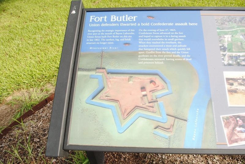
Recognizing the strategic importance of this river port at the mouth of Bayou Lafourche, Union forces built Fort Butler on this site in late 1862. The earthen, log and brick structure no longer exists.On the evening of June 27, 1863, Confederate . . . — — Map (db m155976) HM
(left panel)
"We are still anxious as we have ever been to show the world that the latent courage of the African is aroused, and that , while fighting under the American Flag, we can and will be a wall of fire and death to the enimies of . . . — — Map (db m86323) WM
(center panel)
The Finest of Texas and Arizona,
Lives lost by river and bayou.
We mark their graves,
Remember their names:
Brave Confederates who died
At Fort Butler, June 28, 1863.
Martha M. Boltz
Virginia Division - . . . — — Map (db m86049) WM
On the site directly across from this marker Francis T. Nicholls — Confederate General, Governor and Chief Justice of the State Supreme Court — was born and reared. Additional French marker Francis T. Nicholls 1834-1912 A cet . . . — — Map (db m85191) HM
This great waterway is the most prominent natural feature of Louisiana. The high bank, or levee, you are standing on protects Donaldsonville from flooding. A birds-eye view reveals we are located between two great river bends.Events on and around . . . — — Map (db m155312) HM
Scene of Civil War skirmish in fall of 1862. C.1850 Greek Revival plantation house owned 1854-1869 by Charles A. Kock, a prominent sugar planter. Listed on National Register of Historic Places in 1980. — — Map (db m96047) HM
Louisiana occupied a highly strategic location during the Civil War. Home to both the South's largest city, New Orleans, as well as the largest Confederate training base in the Gulf South at Camp Moore, and positioned to control the mouth of the . . . — — Map (db m114854) HM WM
Union efforts in the western theater of the war centered on seizing control of the many rivers and streams that pierced the Southern heartland. Employing ironclad warships capable of destroying the South's outdated masonry forts, Union forces . . . — — Map (db m114997) HM
Many of the most climactic and large scale battles occurred in the eastern theatre of the war, primarily Virginia. With the capital cities of both North and South in perilous proximity of one another, much of the fighting in the east naturally . . . — — Map (db m114999) HM
Background Throughout the antebellum period, the Northern and the Southern United States developed divergent economies as the North industrialized and commercialized while the South's mild climate and extended growing season allowed it to . . . — — Map (db m115035) HM
First major battle fought along Bayou Lafourche during the War Between the States. Marching from Donaldsonville Union forces under General Weitzel (8th NH, 12th & 13th CT) attacked General Mouton (Ralston's Battery, 24th & 18th LA and the Terrebonne . . . — — Map (db m85249) HM
"Freedom Is Not Free, We Paid An Awful Price For It..." Ray Davis, Lt. Col. USMC. Medal Of Honor, Korea
The Revolutionary War Era Boies David · Boies Joel · Merrill Stephen · Robert Peter · Soileau Jr Noel Etienne · Townsend Samuel The . . . — — Map (db m97457) WM
English: Confederate forces under General Dick Taylor here formed battle line May 16, 1864, barring passage of General Banks' retreating Union Army. The Battle of Mansura ended in withdrawal of Confederates. French: Bataille De . . . — — Map (db m97558) HM
Site of first Catholic school in Avoyelles Parish - 1855. Founded by Daughters of the Cross of Treguier, France, under Mother Mary Hyacinth Le Conniat on request of Bishop Martin. Battle of Mansura, May 16, 1864, began on Convent grounds. — — Map (db m110431) HM
Oldest commercial building site remaining in city. Built by Voinche, native of Paris, France. Later Victorian upper structure on only underground basement in city. Basement used to hide cotton from Union troops during Civil War. — — Map (db m98022) HM
A Confederate military hospital was maintained in this area during the Red River campaign of the Civil War. Patients were housed in a Mr. Richaud's buildings on Monroe Street according to an 1864 newspaper account. — — Map (db m121012) HM
Fort De Russy, four miles north, potent Confederate stronghold defending lower Red River valley, yielded to land attack of General A. J. Smith's Union Army on March 14, 1864.
Lower Plaque
Dedicated June 13, 1954
By the Central . . . — — Map (db m97846) HM
Also known as Norwood's Plantation, fought on May 18, 1864. Last battle of Banks' Red River Campaign. General Richard Taylor's Confederate army failed to prevent Union army crossing Atchafalaya River at Simmesport. — — Map (db m97437) HM
In 1862, when Federal troops captured New Orleans and blockaded the mouth of the Mississippi River, Taylor's army, then in Central Louisiana, retreated from Bank's army and it became necessary to furnish them with supplies. For this purpose a . . . — — Map (db m176941) HM
Facts about the MountainThe mountain was named for James Christopher Driskill. He was born in Hancock County, Georgia, on June 17, 1817. In 1840 he married Eugenia Irwin Walker. In October 1859, Mr. Driskill sold his land in Georgia, and moved . . . — — Map (db m166115) HM
Founded in 1849 as first parish seat for Bienville Parish. Post office est. 1849. 1st Postmaster J. M. Denson. Incorp. 1852. 1860 pop. Of 250 composed of merchants, craftsmen and professionals. Had two churches, two Masonic Lodges, three private . . . — — Map (db m166144) HM
Nearest point of Federal advance on Shreveport during Civil War. About four miles to southwest near confluence of streams Confederates sank steamer New Falls City which blocked passage of Federal gunboats, April 10, 1864. — — Map (db m109795) HM
Cornerstone laid July 1, 1910 by members of R.J. Hancock Chapter, U.D.C. Formally unveiled on Tuesday, August 30, 1910, as a monument to the Confederate soldiers of Bossier Parish. — — Map (db m178396) HM
Located a short distance down this road. Founded 1848 by Fillmore Methodist Church, once located on site. Buried here are Thomas D. Connell, founder of Connell's Cross Roads (now Fillmore), and W.P. Haughton. Also here is O.R. Gelette (1845-1944), . . . — — Map (db m181360) HM
Built c.1875, was residence of Elam S. Dortch, believed to be the last surviving Confederate veteran residing in Bossier Parish. Moved c.1923 to present site from original location nearer river. Listed in National Register of Historic Places, 1982. — — Map (db m109796) HM
This Marks the Site
of
Battery 7
One of the eighteen batteries
and four forts which formed
the Confederate defenses
of Shreveport
1864 – 1865 — — Map (db m138784) HM
Third Courthouse to occupy site since 1860. First Courthouse on site served as Louisiana's Confederate Statehouse during Civil War. Present Courthouse designed by Neild & Somdal architectural firm. Built 1926-28. Served as model for numerous other . . . — — Map (db m109764) HM
912 Commerce Street, 80 feet south of this corner, site of the Benjamin L. Hodge home, where Gen. Smith lived 1863–65 while Commander of Trans-Miss. Dept. CSA. Built 1848, demolished 1960. Originally home of La. Supreme Court Judge Thomas T. . . . — — Map (db m115450) HM
This marks the site of the former home of Henry Watkins Allen Civil War Governor of Louisiana. 1864-1865
Also the site of Battery 10 one of the eighteen batteries and four forts which formed the Confederate defenses of Shreveport. . . . — — Map (db m178309) HM
One block west near mouth of Cross Bayou at Red River the ironclad Missouri and ram Webb built. Missouri armored with railroad iron, In 1863 Webb fought U.S.S. Indianola near Vicksburg. Missouri was surrendered . . . — — Map (db m139539) HM
Formerly Fort Turnbull, built by the Confederates to defend Shreveport, then capital of Louisiana. In 1864, charred logs simulating cannon were used to deter Union forces from attacking. — — Map (db m105309) HM
This marks the site
of
Fort Turnbull
one of the eighteen batteries
and four forts which formed
the Confederate defenses
of Shreveport
1864 – 1865 — — Map (db m105333) HM
Welcome to Greenwood Cemetery the second oldest cemetery in the city of Shreveport, opened in 1892.
The natural beauty of its seventy two acres is only the beginning of an amazing story at the edge of the frontier of American history. From the . . . — — Map (db m169142) HM
Built 1917 on site occupied by a defensive cannon battery during Civil War. Highland Hospital occupied these buildings until 1991. Hospital part is oldest remaining hospital structure in Shreveport. — — Map (db m138818) HM
Built 1898. One of the few remaining large Victorian houses in Highland. Named for owner Thomas C. Lewis, a Captain in the Confederate Army, and a pioneer druggist. — — Map (db m141031) HM
This stone is raised as a tribute of love and loyalty to his old comrades in arms, by Pete Youree, Capt. Commanding, Co. I, Slaybacks Regiment, Joe Shelby's Brigade, Missouri Cavalry.
"We care not whence they came, dear is their lifeless . . . — — Map (db m169100) WM
This Marks the Site
of
Battery 1
One of the eighteen batteries
and four forts which formed
the Confederate defenses
of Shreveport
1864 – 1865 — — Map (db m105334) HM
This Marks the Site
of
Battery 3
One of the eighteen batteries
and four forts which formed
the Confederate defenses
of Shreveport
1864 – 1865 — — Map (db m138788) HM
This Marks the Site
of
Battery 4
One of the eighteen batteries
and four forts which formed
the Confederate defenses
of Shreveport
1864 – 1865 — — Map (db m138787) HM
This Marks the Site
of
Battery 5
One of the eighteen batteries
and four forts which formed
the Confederate defenses
of Shreveport
1864 – 1865 — — Map (db m138780) HM
In 1862 when federal troops captured New Orleans and blockaded the mouth of the Mississippi River, Confederate forces under Maj. Gen. Richard Taylor established headquarters in Central Louisiana, where they successfully stopped Maj. Gen. Nathaniel . . . — — Map (db m136732) HM
Near this spot Confederate soldiers under the command of Col. W.H. Griffin captured the Union gunboats Wave and Granite City in the Battle of Calcasieu Pass, Cameron, Louisiana, on May 6, 1864. These gallant men died for their cause:Union . . . — — Map (db m160087) HM WM
In memory of Henry Seth Bennett, born 1842,
died 1924 and Sarah Baggett Cotton, born 1848
died 1922. Henry was a veteran of the Civil War
was shot through the right lung in the Battle of
Chickamauga, Georgia. Was also with General
Lee when he . . . — — Map (db m196753) HM
One-half mile west was one of four forts built by Confederates in May, 1863 to prevent the ascent of Federal gunboats on the Ouachita River. It was abandoned 1863, but was reoccupied in 1864. — — Map (db m103755) HM
Built in 1860, this ante-bellum building was the point of departure for Confederate troops during the War Between the States. It is one of the finest examples of Southern expression of Greek Architectural style. — — Map (db m180237) HM
Built before 1861, this antebellum building was a point of departure for Confederate troops. It was the site of one or more gun fights during the famous "White Lightning Feud" following the War Between the States. — — Map (db m223760) HM
Within this enclosure are the remains of over 100 Confederate soldiers. Following the Battle of Mansfield, many were infirmed at old Keachie College, where a morgue was established on the second floor of the main building. — — Map (db m188236) HM
Maj. Gen Walker, with Waul's and Surry's brigades, passed here parallel to the road during a charge that turned the Federal left flank and gained a position on the road in rear of Federal line. — — Map (db m105303) HM
Here the Federal line extending from the South turned East along a rail fence forming a V. General Mouton's Division charged this line in the bloodiest part of battle. In this, the first Confederate charge, General Mouton was killed and the gallant . . . — — Map (db m105307) HM
From this point the line extended about 400 yards Northeast, thence East about a mile. It extended about a half mile South from here. — — Map (db m105293) HM
Randal's Brigade of Walker's Texas Infantry Div. charged across this area traveling parallel to the road, supporting Mouton's Division which made the first charge on Randal's left. — — Map (db m105305) HM
In Memory of Capt. Elijah Parsons Petty C.S.A. age 34.
Enlisted May 13, 1862 at Bastrop, Texas, for the war.
Mustered in same day as Capt.. Co. F., 17th Regt. Texas Volunteer Infantry.
Fought in Battle of Mansfield, killed at Pleasant Hill, La. . . . — — Map (db m178236) WM
(Front)
Captain Seth Robert Field
Fell at Battle of Mansfield, April 8, 1864
Aged 29
Member Crescent Regiment of N.O.
(Rear)
Greater Love Hath No Man Than This.
That a Man Lay Down His Life for his Friends - Or His Flag.
A Gentleman . . . — — Map (db m177690) HM WM
(Front)
General Alfred Mouton
1829-1864
(Back)
Prince C. J. de Polignac
Lt. Colonel July 1861
Col. 5th Tenn. Inft. Aug 1862
Brigadier General Feb 1863
Major General Apr 1864
Twice promoted for gallantry on the fields of Richmond, . . . — — Map (db m177857) HM WM
To commemorate the victories of General Dick Taylor and his gallant soldiers at the Battles of Mansfield and Pleasant Hill, April 1864 — — Map (db m177856) HM WM
Lieut. Colonel Clack Died April 24. 1864 from wounds received while leading the charge of the Crescent Regiment - Battle of Mansfield, April 8, 1864. — — Map (db m177937) WM
(Front)
In memory of James H. Beard
Col. of the Crescent Regiment
Fell at the Battle of Mansfield
April 8, 1864
Age 31 Years
Beard
(Back)
First Captain of the Shreveport Greys
(Side)
First to raise the flag when Color Bearer . . . — — Map (db m177851) HM WM
(front)
On April 8, 1864 Maj. Gen. Richard Taylor rode in front of the Louisiana Brigade of Brig. Gen. Alfred Mouton's division to prepare them for the impending battle. Taylor would later write that he had told them...
"As they were . . . — — Map (db m177553) WM
In loving memory of the brave Confederate Soldiers who fought in this battle and to the courageous women who so nobly did their part. — — Map (db m177911) WM
Front
Texas
Remembers her sons by whose valor and
devotion the federal enemy was defeated
at Mansfield, April 8, 1864 and
thereafter in several bloody
engagements driven from the Red River
valley. . . . — — Map (db m105467) WM
Front
Account of
the Battle of Pleasant Hill
The Battlefield After the Fight
On Sunday morning at daybreak I took occasion to visit the scene of Saturday's bloody conflict and a more ghastly spectacle I have not . . . — — Map (db m105410) HM
Front
In memory of the thousands
of Confederate
and Union soldiers buried in
unmarked
graves on this battlefield
Rear
At Pleasant Hill
On the Battle-field at Pleasant Hill, the night . . . — — Map (db m105415) WM
Front
This house is the only remaining structure of the original village of Pleasant Hill. It was occupied by the J.W. Elam family after the Civil War. J.W. Elam was wounded in the eastern theater, was home on recuperation leave, and . . . — — Map (db m105365) HM
The Battle of Pleasant Hill Harper's Weekly May 7, 1864 Pleasant Hill, LA.
(Reverse)
A Tribute to Our Parents
Dr. C.E. "Gene" Poimboeuf established the Pleasant Hill Battlepark in 1994 to preserve the memory of . . . — — Map (db m178395) HM WM
Pierce and Payne College building used for a Federal hospital to care for soldiers wounded in the Battle of Pleasant Hill was near here. — — Map (db m105663) HM
Front
Headquarters Department of the Gulf
(U.S.A)
Alexandria, LA., April 2, 1864
Maj. Gen. H.W. Halleck
Headquarters of the Army
Washington, D.C.
General: — Our troops now occupy . . . — — Map (db m105981) HM
By 1850 Old Pleasant Hill was a thriving community settled by the Blackshear, Jordan, Chapman, Childers and Elam families. Significant structures included the Methodist Church, Pierce-Payne College, Childers Mansion and the Elam House. When the . . . — — Map (db m105386) HM
On this site, then the town of Pleasant Hill, on April 9th, 1864 Gen. Richard Taylor with 12,000 Confederates attacked the town, occupied behind log breastworks by Gen. Banks and 25,000 Federal troops. Through the afternoon the battle raged. That . . . — — Map (db m105402) HM
Pleasant Hill was occupied by
Union armies on April 7, 1864
beginning 3 days of fighting which
culminated in the largest battle
of the Civil War west of the
Mississippi River being fought in and
around the village on April 9, . . . — — Map (db m105983) HM
Front
On this 4 square miles in around the village of Pleasant Hill, approx. 15,000 Confederates under Maj. Gen. Richard Taylor attacked approx. 25,000 Union troops under Maj. Gen. N. P. Banks on April 9, 1864. That was the 3rd day of . . . — — Map (db m105670) HM
Both Gen. Taylor's and Gen Banks' troops obtained drinking water from this cistern while each army occupied Pleasant Hill during the Red River Campaign in April 1864. The stage coach station stood a few feet north of here. — — Map (db m105387) HM
Front
The Village of Pleasant Hill was founded at this location just inside the DeSoto Parish in 1846. Pleasant Hill was a major road intersection with roads radiating to Mansfield, Natchitoches, Grand Ecore, Ft. Jessup, Many, Red River . . . — — Map (db m105673) HM
After the Battle of Pleasant Hill the Confederate army, who had control of the battlefield, began burying the dead soldiers. One of the sites chosen was on the Childers Family property, a part of the battlefield. Here some of the soldiers killed in . . . — — Map (db m178081) HM
Front
Battle for Shreveport
The Confederate capital of Louisiana had been moved to Shreveport, also the headquarters of the Confederate Trans-Mississippi Department (All of the Confederacy west of the Mississippi River). The Red . . . — — Map (db m105977) HM
Front
You are standing on the corner of Main and 1st Streets downtown. The stores and shops were mostly to your left and behind you along Main Street. Some were along 1st Street. About 150 feet to your left was 2nd Street etc. Houses . . . — — Map (db m105979) HM
Front
Brig. Gen. Andrew J. Smith
Third Division Sixteen Army Corps
Second Brigade
14th Iowa - Lieut. Col. Joseph Newbold
27th Iowa - Col. James I. Gilbert
32nd Iowa - Col. John Scott
24th Missouri - Maj. Robert W. Fyan . . . — — Map (db m105357) HM WM
Dedicated to the memory of the Soldiers of the Confederate States Army
1861 * 1865
"Lord God of hosts, be with us yet; lest we forget - lest we forget." — — Map (db m214330) WM
A short distance west of here facing the road, the home of William Robertson was used for the care of Federal Soldiers wounded in a skirmish near by. A mill behind the residence was used to grind grain for soldiers of both armies. — — Map (db m105348) HM
From this point Gen. Green's Texas Cavalry drove Gen. A.L. Lee's Federal Cavalry back toward Pleasant Hill until re-enforced. Then the Confederates withdrew, skirmishing all the way, to Ten Mile Bayou. — — Map (db m105352) HM
(Front)
Dedicated to the memory of
Leutenat General Richard Taylor
Confederate States Army
1826 — 1879
Son of United States President Zachary Taylor
Brother in Law of Confederate States President Jefferson Davis . . . — — Map (db m178253) WM
(Front)
Just south of this spot on April 9, 1864 Sergeant John H. Cook Co. A 119 Illinois Infantry United States Army performed a deed of Most distinguished gallantry in action during The Battle Of Pleasant Hill for which he was . . . — — Map (db m178059) WM
The first courthouse on this site was the Confederate capitol of Louisiana and headquarters of the Trans-Mississippi Dept. C.S.A. from 1863 until May 26, 1865, When the last Confederate flag was lowered. Maj. General Henry W. Allen was inaugurated . . . — — Map (db m229099) HM
Erected by the men and women of East and West Baton Rouge to perpetuate the heroism and patriotic devotion of the noble soldiers from the two parishes who wore the gray and crossed the river with their immortal leaders to rest under the shade of the . . . — — Map (db m92984) WM
Civil War Baton Rouge
Control of the Mississippi River and New Orleans was vital to
the Union war effort. In April 1862, Union gunboats steamed
up the river. The vessels evaded the guns of Confederate-held
forts located below New Orleans, . . . — — Map (db m131637) HM
Louisiana seceded from the Union January 26, 1861, and a blue pelican flag replaced the U.S. flag. The National Flag of Louisiana, adopted February 12, 1861, became the second state flag until Louisiana joined the Confederacy March 21. There were . . . — — Map (db m91827) HM
This Gothic Revival structure was designed by James Harrison Dakin. The Louisiana Secession Ordinance was adopted here in 1861. The interior was burned in December 1862 while the building was occupied by Federal troops. Reconstructed by William . . . — — Map (db m87892) HM
Site of the Baton Rouge College 1838-44, and the Louisiana Institute for the Deaf and Blind 1852-72. A five-story brick building completed in 1858 was used as a general hospital during the Union occupation of the city. It housed the Louisiana State . . . — — Map (db m96680) HM
Cast Iron Columns The cast-iron columns which supported the former Picnic Hill pavilion structure were originally part of an old Baton Rouge market pavilion that was built in 1859 and razed in 1954.The columns have been salvaged and are now . . . — — Map (db m99382) HM
This building, erected c. 1835 as a powder magazine for a U.S. Army Post and Arsenal which used this area from 1810-1885, except in 1861-1862 when held by the Confederacy. In 1962 this building was restored and the museum established. — — Map (db m113860) HM
On August 3, 1862, Confederate troops from Alabama, Kentucky, Tennessee, Mississippi, and Louisiana under General John C. Breckinridge attacked from the east in an unsuccessful attempt to dislodge Union forces holding the city. Casualties were . . . — — Map (db m85663) HM
According to local tradition, Charles Weick named his newly purchased saloon the day after Fort Sumter was fired on, 1861, and put the cannon out front for atmosphere. It was one of the city's most popular saloons until prohibition. — — Map (db m88273) HM
On this site stood the home of Sarah Morgan Dawson (1842-1909) who wrote A Confederate Girl's Diary, which has become a Civil War classic. The diary depicts the occupation of Baton Rouge by Union forces. — — Map (db m92412) HM
360 entries matched your criteria. The first 100 are listed above. Next 100 ⊳