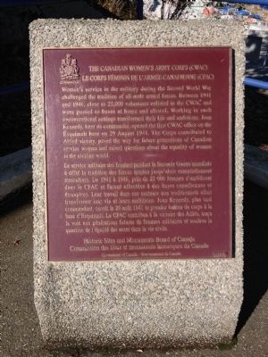
Canadian Women's Army Corps (CWAC) Women's service in the military during the Second World War challenged the tradition of all-male armed forces. Between 1941 and 1946, close to 22,000 volunteers enlisted in the CWAC and were posted to bases at home . . . — — Map (db m72873) HM
In memory of the men
of this district
who gave their lives
in the Great War
1914 - 1918
——— • ———
W.I. Apps • James Arden • H.H. Bedford • V. Cleaves • G.J. Coward • G.C. Cruse • Dean Arnold • H.A. . . . — — Map (db m75480) WM
During the First World War, Victoria was unprepared to fend off air attacks. In 1921, the 2nd AA (Anti-Aircraft) battery was formed in Victoria. No AA guns existed in Canada, so the unit made do with 13-pounder guns on a locally improvised . . . — — Map (db m98996) HM
Through arctic cold, desert heat, or jungle humidity, the rugged reliability of this no-frills "Vehicle, General Purpose" (G.P.) made it the most successful and recognizable Allied vehicle of the Second World War. Between 1939 and 1945 more . . . — — Map (db m99346) HM
During the 1950s this type of anti-aircraft gun was part of the Victoria-Esquimalt defences, although it was not used here at Fort Rodd Hill.
This American-made weapon had begun to replace the British-designed 3.7-inch gun as the Canadian . . . — — Map (db m75031) HM
This building was constructed in about 1900 to served as a canteen where the off-duty soldier could make purchases from a limited stock, drink beer and relax.
The building was used as a canteen during summer training periods at Fort Rodd . . . — — Map (db m98860) HM
The harbours at Victoria and Esquimalt, and the adjacent coastline were defended by temporary gun emplacements from 1878. International crises during the latter part of the century led to an agreement between the Canadian and British governments . . . — — Map (db m75210) HM
Defence Electric Lights on both sides of Esquimalt Harbour entrance were used to illuminate targets for the guns at night. Engine rooms generated power for the lights. Lights and engines were controlled from this Defence Electric Light . . . — — Map (db m99440) HM
This wall protected the battery from attack from the rear. It was both a protected position for riflemen and an obstacle. Barbed wire entanglements and natural cliff faces provided additional defence along the remainder of the battery . . . — — Map (db m99395) HM
One 6-inch gun on a disappearing carriage was mounted in this emplacement. The wall and sunken emplacement helped to conceal and protect the gun and crew from enemy bombardment. The concrete apron and earth glacis extending away from the top of . . . — — Map (db m76336) HM
During the Second World War, steel mesh anti-torpedo and anti-submarine nets and a log-boom, were erected between this shore and the island occupied by Fisgard Lighthouse, and across to Duntze Head on the opposite side of the harbour. The . . . — — Map (db m98995) HM
The first Royal Navy warship dropped anchor in Esquimalt Harbour in 1848. Since then, the harbour has witnessed a fascinating evolution of naval power. Though global politics and weapons systems may change, Esquimalt remains a major strategic . . . — — Map (db m99461) HM
When the Second World War began in 1939, tents were used to accommodate the sudden influx of troops. They were quickly replaced by temporary wooden huts of this type. This building is the only example that has survived in place. It was an . . . — — Map (db m99359) HM
During the Second World War, a total of 17 modern searchlights replaced the four original defence electric lights. The 60-inch searchlight mounted in this emplacement was one of two installed at Fort Rodd Hill in 1940. Two similar . . . — — Map (db m98994) HM
Mobilized on August 26, 1939—two weeks before Canada declared war on Germany—troops sent to Fort Rodd Hill lived in tents until wooden barracks could be built. Out of more than twenty of these buildings at Fort Rodd Hill, only one . . . — — Map (db m99236) HM
The ten-man gun crew and ammunition detachment worked closely together to ensure safe and precise loading and firing of the 6-inch guns. They followed a sequence when in action:
1) Gun crew and ammunition detachment alerted and take post at . . . — — Map (db m99058) HM
This structure was designed to accommodate the guard when the battery was fully manned.
Consisting of three or four soldiers commanded by a non-commissioned officer, the guard provided sentries to control the gate and patrol the battery . . . — — Map (db m75775) HM
This viewpoint illustrates the commanding position required for a coast defence gun battery. The trees in front were topped when the emplacement was in use.
A total of 27 locations were occupied by the coast defences between 1878 and 1956. . . . — — Map (db m99460) HM
Excavated from solid rock, this underground magazine provided a secure and dry storage area for ammunition.
The shells were wheeled to the guns. The cartridges were carried up the passageways and passed through the issue hatches. Strict . . . — — Map (db m99057) HM
A coast artillery battery consists of one or more gun emplacements and supporting structures and equipment. Its role was defensive; to prevent attack by enemy warships through the use of artillery.
The layout of Upper Battery is typical of . . . — — Map (db m75248) HM
These batteries were constructed at Fort Rodd Hill between 1895 and 1900, as part of the defences of Esquimalt Harbour.
Upper and Lower Batteries, with their three large 6 inch guns, were designed to counter bombard enemy warships. Belmont . . . — — Map (db m75216) HM
This building was constructed in 1897. It was built of brick to British Royal Engineer specifications and during its life it was subjected to several modifications.
Originally it was to accommodate a Master Gunner and his family, but a . . . — — Map (db m99253) HM
On April 22, 1942, 273 men, women and children of Japanese ancestry were exiled from their homes in the Greater Victoria area. None of the survivors of this event ever returned to Victoria to re-establish a home.
On August 4, 1992, 67 . . . — — Map (db m49127) HM
This memorial commemorates the 150 Victorians of Japanese descent who are buried in this historic cemetery, beginning in 1887.
During the 1940's, when no person of Japanese descent was allowed to remain within 100 miles of the West Coast, . . . — — Map (db m74695) HM
“They died the noblest death a man may die, fighting for god, and right and liberty, and such a death is immortality.”
Korea
1950 – 1953
[On the back]
In Recognition of the Services of the Canadian Forces and Canadian . . . — — Map (db m48933) WM
In 1942, over 21,000 Japanese Canadians were unjustifiably removed from British Columbia's coast. Tashme internment camp held over 2,644 men, women, and children who lived in 347 crude tarpaper shacks. Despite horrible living conditions, the . . . — — Map (db m187902) HM
In 1942, over 21,000 Japanese Canadians were unjustifiably removed from British Columbia's coast. Despite their protests many men aged 19 to 60+ were torn from their families and sent to road camps like Red Pass. Internees gave 290,238 man-days of . . . — — Map (db m187875) HM
This area was the site of a coast defence fort manned during WW II
1939-1945
by The Royal Canadian Artillery
Batteries
31st Heavy
58th Heavy
85th Heavy — — Map (db m54578) HM
Crew 5, Wt 30 tonnes, Speed 40 km/hr, armament - 57 mm main gun, 2 x 30 cal mg, in service 1941-1945.
The Ram tank was designed and built in Canada as part of Canada's contribution to the allied war effort in WW II. A total of 1949 Ram tanks . . . — — Map (db m54263) HM
M4A3E8, Crew 5, Wt 32 tonnes, speed 48 km/hr armament - 76 mm main gun, 2 x 30 cal mg in service 1943-1970
On 8/9 August 1944, the British Columbia Regiment (Duke of Connaught's Own), then designated Canadian 28th Armoured Regiment, was commanded . . . — — Map (db m53942) HM
Her Majesty's Canadian Ship Discovery was commissioned on November 1, 1941. Thousands of men and women have been recruited and trained at these naval reserve facilities of Deadman's Island for service to Canada in peace and war.
World War . . . — — Map (db m236197) HM
In 1942, over 21,000 Japanese Canadians were unjustifiably removed from British Columbia’s coast. Over 300 men, women and children lived in East Lillooet, one of four internment camps in this region. They built 62 wooden shacks, a school and . . . — — Map (db m187890) HM
Strategically located at the narrowing of Johnstone Strait lie the intact remains of Canadian artillery defences. Built in 1937-1945, they deterred seaborne attacks on Vancouver during World War II. The island and its military legacy are protected . . . — — Map (db m187888) HM