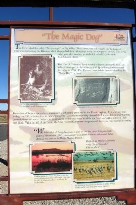
The Utes called this valley “Tavi-we-a-gat” or Big Valley. They came here following in the footsteps of their ancestors along this Camino; their dogs pulled their belongings along the now paved byway. This fertile valley provided . . . — — Map (db m71876) HM
Isolated from the rest of Colorado, the San Luis Valley is often a forgotten place. For Native American tribes including the Utes, Apache, Navajos, and others, this Valley is a source of life - a place where humans and spirit enter and leave . . . — — Map (db m71875) HM
¡Bienvenidos! Caminantes!
Come! Take a walk with us. We know an old song, El Caminante, which tells of taking a long walk along the ancient roads. Like the first prehistoric inhabitants, you too are a ‘caminante’, or one who walks upon . . . — — Map (db m71877) HM
You have entered the land of the Río Bravo del Norte, the northernmost outpost of sixteenth century Spain. To the Spanish people, the San Luis Valley was a wild and unexplored place known only to the Native people. Amidst the beauty and towering . . . — — Map (db m160674) HM
¡Bienvenidos! Caminantes!
Come! Take a walk with us. We know an old song, El Caminante, which tells of taking a long walk along the ancient roads. Like the first prehistoric inhabitants, you too are a ‘caminante’, or one who walks upon . . . — — Map (db m160668) HM
[left to right]
This Payan corrugated jar was found here at the Pit House site and was used for storage of corn, beans and wild seeds.
Mancos [and] Payan Corrugated
This style of pottery was often used for cooking. The corrugations helped the . . . — — Map (db m160560) HM
The Northern San Juan Surface Pit House that was constructed here is composed of one large room used as a dwelling area and 3 rectangular room blocks used for storage.
[Left illustration caption reads]
Typical cross-section of surface pit . . . — — Map (db m160562) HM
Kivas or Ceremonial Houses were not only used for religious ceremonies but may have been used for governmental and social events as well. Kivas varied in size and had flat or cribbed roofs.
The cribbed roofs of kivas were constructed of logs laid . . . — — Map (db m160561) HM
Pagosa Springs has a rich history, beginning with the Anasazi Indians. Later the Utes, Navajos and Apaches inhabited this beautiful corner of the Southwest. They also visited the great “Pagosah” hot springs which they believed had . . . — — Map (db m27527) HM
Questions Unanswered
A thousand years ago, a civilization flourished here. What pulled people here — and why did they leave after 200 years?
Why did they build so high above the fields in the valley, the water, and other resources? . . . — — Map (db m153328) HM
Learning About Our Past, Preserving Our Legacy
The extraordinary archaeological resources at Chimney Rock have helped illuminate the history of the ancestral Puebloans who lived here over a thousand years ago. They built structures from the . . . — — Map (db m153331) HM
"There really is a Place Called Baca County;
I think she’s mighty fine;
She was good enough for my dad’s kids;
Likewise she’ll do for mine;
Her sunrises are all colors;
Her sunsets are all the same;
The only thing she needs more . . . — — Map (db m106474) HM
Dinosaur Freeway Geology of John Martin Reservoir
is part of the Dakota sandstone
formations which extend from Denver,
Colorado to Tucumcari, New Mexico.
In the Cretaceous period the region
was bordered with lakes, swamps . . . — — Map (db m181091) HM
This region was once buffalo hunting grounds for the Cheyenne, Apache, Arapaho, Kiowa and Comanche. Tribes followed the buffalo throughout the plains and controlled the land. During this time, everything south of the Arkansas river was Mexico and . . . — — Map (db m120709) HM
Native peoples traveled through the Upper Arkansas Valley for centuries before European and American explorers.
Ute, Comanche and other tribes traveled on foot until the arrival of the Spanish and the introduction of the horse in the 1600’s. . . . — — Map (db m107827) HM
Frustrated in their attempt to climb Pike’s Peak on November 27, 1806, Zebulon Pike and his party of 15 trudged on through South Park looking for the Red River, southern boundary of the Louisiana Purchase. After crossing Trout Creek Pass, the . . . — — Map (db m127876) HM
Marker A:Finding Our Roots Following ancient paths The history of Chaffee County as part of the United States began in 1803, with the purchase of the Louisiana Territory from France. But human history was established here centuries . . . — — Map (db m116085) HM
This memorial is the
Property of the State of Colorado
———
Fort Garland
United States military outpost
to protect settlers from
hostile Indians. Named for
Brig. Gen. John Garland . . . — — Map (db m22731) HM
Front
The Soldier’s Life
Fort Garland housed infantry and cavalry units. During the 1870’s the famed Buffalo Soldiers—African-American cavalrymen—were also posted here. For all soldiers—and their . . . — — Map (db m71032) HM WM
In 1844. Mathew Kinkead established the first American-owned cattle ranch tn the Rocky Mountains at the junction of the North and South Hardscrabble Creeks.
Even before Kinkead settled at the mouth of Hardscrabble Canyon, the canyon had been an . . . — — Map (db m153187) HM
The long battle between colonial Spain and the Comanche people climaxed in 1779, when Juan Batista de Anza's army killed the great chief Cuerno Verde (Green Horn) southeast of here at the foot of Greenhorn Mountain. De Anza, the governor of New . . . — — Map (db m219465) HM
Much of this area's early history occurred on nearby trading posts and settlements, which lived and died leaving little trace of their existence. Such was the post built one mile west by Maurice Leduc in the 1830's and the village of Hardscrabble . . . — — Map (db m153183) HM
This ancient tree was once part of a grove of native cottonwoods under which the local Ute Indians would camp and hold council prior to 1881. An Indian trail passed nearby. It has been identified as the Ute Council Tree since 1930, when the local . . . — — Map (db m119897) HM
This tablet is the property of the State of Colorado ——— Immediately north-east of this point and covering much of Block 18 East Denver stood the famous Elephant Corral camp ground, immigrant headquarters and stock . . . — — Map (db m203481) HM
This building is named for Edward W. Wynkoop (1836-1891) to honor his peacemaking efforts, though unsuccessful, to resolve the Indian-white conflict which resulted tragically in the Sand Creek Massacre in 1864.
Exaggerated reports of . . . — — Map (db m97294) HM
The controversy surrounding this Civil War Monument has become a symbol of Coloradans' struggle to understand and take responsibility for our past. On November 29, 1864, Colorado's First and Third Cavalry, commanded by Colonel John Chivington, . . . — — Map (db m6755) HM
Denver's first settlement was along the confluence of the South Platte River and Cherry Creek. Arapahoe Indians named Cherry Creek for the wild chokecherries they harvested here in the fall. They respected the stream's power and warned the first . . . — — Map (db m96283) HM
The legend says that Denver's early settlers, who made their camp on the banks of Cherry Creek, laughed at the Arapaho, a local Indian tribe, for making their camp inconveniently far from the water's edge.
The Arapaho warned the settlers of . . . — — Map (db m135440) HM
Before the founding of the City of Denver, the tribe that camped in the area called themselves “Inuna-ina" meaning, “Our people.”
This tribe was also known as “Arapaho,” the word for “trader” or “buyer” in Pawnee. Denver’s founders honored . . . — — Map (db m135442) HM
At this location on April 23, 1865, assassins shot and killed 1st Colorado Cavalary Officer Capt. Silas S. Soule. During the infamous Sand Creek Massacre of November 29, 1864, Soule had disobeyed orders by refusing to fire on Chief Black Kettle's . . . — — Map (db m67133) HM
This tablet is the property of the State of Colorado ——— One mile north of this point Gold Was Discovered on June 22, 1850, by a party of California-bound Cherokees. The discovery was made by Louis Ralston, whose name . . . — — Map (db m203500) HM
Ancestral Puebloans
Beginning around A.D. 600, Ancestral Puebloans built Colorado's first permanent towns in the canyon country south of here. Hundreds of these settlements sprawled across the desert, with an overall population possibly . . . — — Map (db m160128) HM
[Text blocks, counter-clockwise from top left, read]
• The Unaweep/Tabeguache Scenic and Historic Byway is a remarkable tour through western Colorado's remote canyon country. Copper, radium, vanadium, and uranium all enticed miners here; . . . — — Map (db m160155) HM
Why East?
The purpose of Fathers Dominguez and Escalante's journey through this region in 1776 was to find a route to Spanish missions in Monterey. During the first 2½ weeks of the expedition, the Fathers' route took them to the northwest, . . . — — Map (db m160107) HM
This tablet is the
property of the State of Colorado
——
Franktown
Named for J. Frank Gardiner, a
pioneer who settled here in 1859.
First known as "California Ranch,"
it was a way . . . — — Map (db m96174) HM
This tablet is the
property of the State of Colorado
— —
Due West ¼ mile stood the
TWENTY MILE HOUSE
(Twenty miles from Denver)
First house built in Parker, 1864.
On the . . . — — Map (db m96176) HM
This marks the site of the
Old Fort and Stockade
built by
Pioneers of Colorado City
used in defense against
the Indians in 1864 and 1868
Constructed of logs
set on end
_____
Erected by
Old . . . — — Map (db m96054) HM
Welcome!
Rock ledge Ranch Historic Site is a living history museum that allows visitors to experience the lives of the people who dwelled, worked, hunted, herded and raised families here from the 1700s to the early 20th century. This . . . — — Map (db m46002) HM
1775-1835 American Indian Area
Discover the history and culture of the American Indians who lived in the Central Front Range of the Rocky Mountains. Visitors will have an opportunity to see an elk or buffalo hide tepee, a wide variety of . . . — — Map (db m135562) HM
The Central Garden Trail is a moderate, one-mile round-trip loop. It is paved and wheelchair accessible. This trail will take you between the towering Gateway Rocks into the heart of Garden of the Gods Park. Along the way you will have the . . . — — Map (db m72936) HM
This memorial is the
Property of the State of Colorado
Ute Pass
Named from the old Ute Trail
which led from South Park
through Manitou to the Plains.
Traversed by the Utes on
hunting and war expeditions.
Improved highway built . . . — — Map (db m32663) HM
This tablet is the
property of the State of Colorado
_____
Due south 610 feet is the
Old Stone Fort
built at the pioneer home of
David McShane. Constructed as a
defense against Arapaho and . . . — — Map (db m104869) HM
The first Anglo explorers journeyed th[r]ough this area in the early-to-mid-1800s. The Homestead Act of 1862 opened the land to pioneers to select a 160-acre parcel to establish a dwelling and start their adventure in the west. First pioneers on . . . — — Map (db m158304) HM
Trail Under Siege Indians of Colorado’s High Plains
Kiowa and Comanche Indians migrated to these prairies in the 1700s, followed by Cheyennes and Arapahos in the early 1800s. The region’s vast grasslands, thick bison herds, and brisk fur . . . — — Map (db m45756) HM
The Ute Indians inhabited this region long before European explorers set foot on this continent. Other tribes like the Cheyenne, Arapaho, Kiowa, and the Comanche moved through the area following herds of buffalo. The Utes left traces of their . . . — — Map (db m153077) HM
[Side A:]
Rainbow Route
Completion of this road opens up a scenic paradise unequalled in any other state of the Union and unsurpassed by the scenic gems of the Wild West.
Governor George A. Carlson on the opening of the . . . — — Map (db m55639) HM
Grand Lake was formed by glacial action, the ice gouged back into the mountains to the east. As the climate warmed, the glacier melted irregularly, leaving ridges of clay and rocks called moraines. Moraines edge the west and north shore, and are . . . — — Map (db m129855) HM
The largest natural lake in Colorado Formed by glaciation 30,000 years ago Long known as the headwaters of the Colorado River. It is included in the Colorado-Big Thompson Project. Water from here flows through the “Adams Tunnel” to Estes . . . — — Map (db m129892) HM
This miner's cabin is one of the oldest buildings left standing in the Kawuneeche Valley. In 1902, Joseph Fleshuts homesteaded 160 acres here with the intent to live on the land for at least five years. Life must have been hard. In 1911 he abruptly . . . — — Map (db m89117) HM
The Ute Indians who inhabited what is now Colorado, Utah, and northern New Mexico were organized into small family bands. They migrated seasonally between the mountains and the deserts and foothills in search of game and wild plants and to . . . — — Map (db m177848) HM
Prior to 1820, North Park was a favorite summer
hunting ground for a number of Native American
tribes, especially the Utes and Arapaho. Other tribes
included the Crow, Sioux, and Cheyenne. These
early native people were drawn to North Park . . . — — Map (db m240763) HM
For many years, the Ute Indians lived in the mountains west of the mouth of Clear Creek Canyon, hunting and trading with area travelers. The Arapaho, refugees from the Great Lakes region, and the Cheyenne arrived in the area during the mid-18th . . . — — Map (db m49899) HM
This stunning sculpture provides beauty and grace to the Clear Creek and Table Mountain backdrop. She was placed to honor the Native Americans indigenous to Golden, primarily the Arapahoe, Ute and Cheyenne. Funding was sponsored by Peak Properties . . . — — Map (db m49894) HM
Is Buffalo Bill really buried here?
Yes! On the day of his burial, Cody's casket was opened for one final viewing by his family, close friends, and many of the 20,000 others who attended the service. Stories of his being buried anywhere else . . . — — Map (db m152719) HM
Chief's Village at Sand Creek
The Cheyenne and Arapaho Village at Sand Creek was a
Chief's village with 33 chiefs and headmen present. To be
a chief in the Cheyenne and Arapaho Tribes is to undertake
a responsibility so vast only . . . — — Map (db m181887) HM WM
Cheyenne Peace Chief Black Kettle As the soldiers' gunfire increased, and artillery began
firing deadly salvos toward the village, Black Kettle
remained in camp. In a final show of desperate hope,
the chief hoisted an American and . . . — — Map (db m182290) HM WM
Activity in the Villages
As the attack moved toward the northern-most Cheyenne
and Arapaho encampments, tribal members sought to
escape, even as artillery shells exploded overhead.
Within the first hour of the attack command and . . . — — Map (db m181252) HM WM
A Camp at Sand Creek
Along the northern edge of the Pónoeo 'hé'e (Dry River) or
Sand Creek, sit about 156 lodges or tipis, with hoóxé’e or
tipi poles rising into the sky. Traditionally positioned with
their entrances open toward . . . — — Map (db m181240) HM
Some Soldiers Refuse to Fight Shortly after opening fire on the village, 1st Regiment
soldiers moved along both sides of the village. Cpt. Soule
and Lt. Cramer led their men west, around the fighting,
and purposefully did not . . . — — Map (db m181873) HM
In the Cheyenne and Arapaho camps, the early hours of
November 29, 1864 started like any other day – people up
before sunrise greeted the day cautiously, but with little
trepidation. “Heap of Buffalos Coming!”
Always alert to . . . — — Map (db m180915) HM
The Fort Lyon Reservation
Created in 1861 by the Treaty of Fort Wise, the Upper
Arkansas Agency Reservation, known later as the Fort
Lyon Reservation, was established for those Cheyenne and
Arapaho living below the South Platte . . . — — Map (db m180906) HM
Grasslands are some of the most biologicaly productive but endangered ecosystems on
Earth, and are the major ecosystem in the
Great Plains. The prairie is integral in shaping this cultural landscape. It supports the interaction and survival of . . . — — Map (db m185037) HM
Women at Sand Creek
During the soldiers' attack, men in the village put up the
best defense they could. But displays of bravery were not
exclusive to warriors; many women risked their lives to
protect their families as well. Women . . . — — Map (db m181477) HM
"Many years have passed. The land is still here. We lived here, our clans lived here. The land here is our home - we have come back home."
Arapaho:
Wonoo3ei’i ceciniihi’ coowoo’ou’u. Nih’iine’etiino’ hiitiino. Neito’eininoo . . . — — Map (db m180924) HM WM
Sacred Memory
Sand Creek is a place where culture and history are at the
center of controversy, trauma, anger, and forgiveness. A
place to reflect on the past as well as the future, the Sand
Creek Massacre teaches powerful . . . — — Map (db m181063) HM WM
Camp Site Along the Smokey Hill Lodgepole Trail In the 1800's Plains tribes like the Cheyenne and Arapaho
moved their camps using travois to carry their possessions.
Made by securing lodge poles to a horse, the ends of . . . — — Map (db m180907) HM
3rd Regiment Attacks
Hearing gun fire from the vicinity of the village,
soldiers of the 3rd Regiment, approximately two
miles west of this location, disobeyed orders and
turned their horses toward the bluffs. Somewhere
in the . . . — — Map (db m181097) HM WM
On November 29, 1864, U.S. Colonel John Chivington and 700 volunteer troops attacked an encampment of Cheyenne and Arapaho along Sand Creek. The thunderous approach of horses galloping toward camp at dawn sent hundreds fleeing from their tipis. Many . . . — — Map (db m180927) HM
Pony Herds Threatened
First to see soldiers approaching were two young men, King
Fisher and Little Bear, who were tending the horse herds
grazing to the south. In 1906, Little Bear described that
fateful day: “As I was going . . . — — Map (db m181575) HM
We ran up the creek with the cavalry following us…The dry bed of the stream was
now a terrible sight: men, women, and children lying thickly scattered on the sand, some dead and the rest too badly wounded to move… George . . . — — Map (db m181944) HM WM
The flag before you represents the flag that flew from Chief Black Kettle's lodge on the morning of November
29, 1864, when his encampment of friendly Cheyenne and Arapaho was brutally attacked by the Colorado
(U.S.) Volunteer Cavalry. The . . . — — Map (db m184925) HM
Sand Creek Massacre
National Historic Site
Sand Creek Massacre National Historic Site memorializes the massacre of nearly two hundred Cheyenne and Arapaho Indians.
Near dawn on November 29, 1864, detachments of the 1st . . . — — Map (db m107179) HM
Though the Sand Creek Massacre has long passed, memories live on. Cheyenne and Arapaho return here to pray and pay tribute to ancestors who both perished and survived that dreadful day.
Ever resilient, the Cheyenne and Arapaho nations of today . . . — — Map (db m181060) HM
Plains Indian Life
By the nineteenth century, Colorado’s southeastern plains country was home to many native peoples, including Comanches, Kiowas, Plains Apaches, Arapahos, and Cheyennes. Although vastly different in language and . . . — — Map (db m107178) HM
"All we ask is that we may have peace with the whites...We want to take good tidings home to our people, that they may sleep in peace."
Cheyenne Chief Black Kettle
As tensions mounted, Chiefs Black Kettle and Left Hand pled . . . — — Map (db m181243) HM
”Many years have passed. The land is still here. We lived here, our clans lived here. The land here is our home - we have come back home.”
Arapaho:
Wonoo3ei’i ceciniihi’ coowoo’ou’u. Nih’iine’etiino’ hiitiino. Neito’eininoo . . . — — Map (db m180923) HM
In the aftermath of Sand Creek, federal investigations and military inquiry took place. Dozens of eyewitness' provided testimony. Taken in Washington, D.C., Denver City, Fort Lyon, and other locations, officers, soldiers, and civilians came forth. . . . — — Map (db m181061) HM
A barrage of arms fire was leveled against the Cheyenne and Arapaho. Amid the wild confusion, soldiers noticed people at the village “... going slowly away in a sort of listless, and dazed, or confused manner ...” Throughout the morning and into the . . . — — Map (db m181242) HM
For years, Cheyenne and Arapaho traveled and hunted the Great Plains in the shadow of the Rocky Mountains. But in 1858, gold fever struck in Colorado Territory. Miners rushed in and tens of thousands of settlers followed. Competition for land became . . . — — Map (db m181241) HM
Originated on the site of a U.S. Cavalry post established in 1880 at Hesperus. From 1891 until 1956 the old fort was operated as an Indian school, a vocational high school and a junior college.
The first president of the college was Charles . . . — — Map (db m22765) HM
Captain Charles H. Baker, who discovered gold in the San Juan in 1860, led a party of prospectors to this area in 1861. They placer mined on El Rio de las Animas, built the first bridge (300 feet north), and established the town called Animas . . . — — Map (db m177471) HM
Born in Virginia, Texas Jack came west after the Civil War at age 16 to become a cowboy. He later made a name for himself as a plainsman and U.S. government scout who led the Pawnee Indians on their summer hunts and was guide for such notables as . . . — — Map (db m121768) HM
Whose feet walked here first? As you walk this trail, imagine walking with you are other visitors, very different from those you would see today. They carry all their necessary gear: tools, food, clothing, and shelter. Rocky Mountain National Park . . . — — Map (db m162062) HM
Trinidad: A Place to Explore and
Until the 1700s, the Ute people traveled the Mountains of western Colorado, and the Apache controlled the eastern plains. The Apache gave way to the Comanche between 1720 and 1805, and the Ute extended . . . — — Map (db m188717) HM
Panel 1
Arriba
In frontier Arriba (locally pronounced "AIR-uh-buh"), the only thing
more scarce than water was whiskey. Charles Creel, who founded
the town in 1888 to greet the advancing Chicago, Rock Island &
Pacific . . . — — Map (db m89381) HM
Due west 940 feet stood
“Fort Wicked"
Originally Godfrey’s Ranch
Famous Overland Stage Station
One of the few posts withstanding the Indian uprising of 1864 on the road to Colorado.
Named from the . . . — — Map (db m61998) HM
3 miles southeast from this point is the site of theBattle of Summit Springs
Last engagement with Plains Indians in Colorado, July 11, 1869. Cheyennes who raided western Kansas were attacked by General E. A. Carr with the Fifth U.S. Cavalry . . . — — Map (db m61997) HM
The first people to witness this view were probably Indians who had to scale the steep cliffs and talus slopes. Later, ranchers dug narrow passages up into the canyons to bring their cattle to graze in the rich highland trails below.
Begun during . . . — — Map (db m61910) HM
Built in this valley in 1837 by mountain men Thompson, Craig and Sinclair, what is the winter rendezvous of traders, trappers and Indians until 1840, after which it fell into decay and was abandoned. — — Map (db m154044) HM
Canyons of the Ancients National Monument encompasses 164,000 acres of southwest Colorado. It was established on June 9, 2000, to protect the cultural and natural resources of the canyons and mesas.
For hundreds of years, the canyons and . . . — — Map (db m160230) HM
Starting in the 1880's, construction of the original irrigation canals and lateral ditches was done by hand using teams of horses and mules. Equipment was simple and crude by today's standards, consisting of horse drawn graders, scrapers and hand . . . — — Map (db m153384) HM
For more than 12,000 years, Native American people have inhabited this area. As the Ice Age ended, these nomadic people hunted bison and mastodons in the valleys, and gathered plants along the edges of glacial lakes and wetlands. . . . — — Map (db m160236) HM
The McElmo Creek Flume No. 6 is the last remaining example of 104 Wooden Flumes used to convey water diverted from the Dolores River to irrigate croplands and provide domestic water to the greater Montezuma Valley.
Cortez, Montezuma County and . . . — — Map (db m153387) HM
Over the last 150 years, technology to store water and deliver it to local farmland has continually changed and improved. Increasing efficiency, reducing salinity, applying water to uneven or elevated areas, and automating systems are among the . . . — — Map (db m153388) HM
Sleeping Ute Mountain
Sprawling ten miles across the highlands west of here, Sleeping Ute Mountain comprises no fewer than seven separate peaks — and at least as many legends. According to one, the mountain took shape eons ago when a . . . — — Map (db m153394) HM
169 entries matched your criteria. The first 100 are listed above. The final 69 ⊳