Oct. 6, Day 33 of the forced march from their Indiana homeland, 850 Potawatomi Indians camped nearby after traveling 18 miles that day. As the barren land only allowed one choice for encampment, it was named "Hobson's Choice". Water on route was . . . — — Map (db m181376) HM
Warmer climate ends the Ice Age and encourages the growth of different plants. Deciduous trees replace open spruce woodlands. Many Ice Age animals become extinct, and woodland animals such as white-tailed deer are more common. About 7,000 years ago . . . — — Map (db m150277) HM
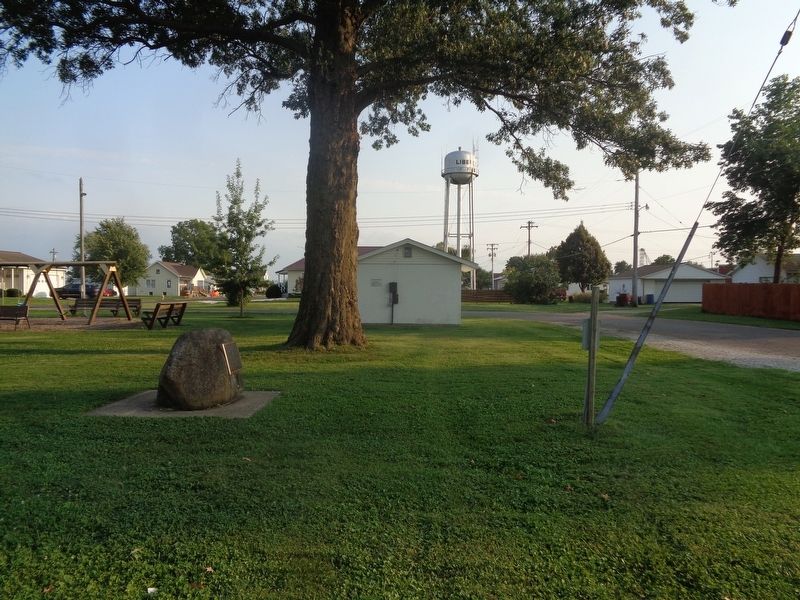
From October 8-10, 1838, more than 800 Potawatomi Indians were encamped here in Quincy, Illinois and directly across the Mississippi River in Missouri. They were being forced to march from Southern Michigan and Northern Indiana to Eastern Kansas . . . — — Map (db m150021) HM
In 1888, the Quincy Boulevard & Park Association was created to determine the location of parks and to develop beautiful boulevards. As early as 1894, E.J. Parker, the Association's president, began discussions with the city to acquire land where . . . — — Map (db m150072) HM
From 1818 through 1851 groups of American Indians were forcibly removed from states on the east side of the Mississippi River to territories on the west side. One of these removals was the Potawatomi Trail of Death, conducted by William Polke, . . . — — Map (db m181375) HM
"Archie Williams was one of the strongest-minded and clearest-minded men in Illinois" (A. Lincoln). Lincoln and his friend Archibald Williams had much in common. Both were born in Kentucky and moved to Illinois. Williams coming to Quincy . . . — — Map (db m58790) HM
In AD 1673, Pere Jacques Marquette, a Jesuit missionary, Louis Jolliet, a mapmaker, and a small party of Frenchmen explore the Mississippi River by canoe. In eastern Missouri they find a village of the Peoria, one of the tribes that speaks the . . . — — Map (db m150074) HM
Farming changes almost every part of life and leads to the development of Mississippian culture. Mississippian farmers grow corn, squash, beans, and some native plants. They also hunt, gather, and fish, producing enough food to feed towns and . . . — — Map (db m150286) HM
People arrive in North America from Asia more than 14,000 years ago at the end of the last Ice Age. The formation of glaciers lowers sea level and exposes a wide land bridge connecting Asia and North America where the Bering Sea is today.
In . . . — — Map (db m150287) HM
On October 7, 1838 nearly 850 Potawatomi Indians camped near here on Mill Creek on the forced removal from Indiana to Kansas. The diary records that they traveled 12 miles that day A child died. — — Map (db m181377) HM
In 1804, the Sac and Fox cede their land between the Illinois and Mississippi Rivers to the United States. Nine years later, General Howard and 1,400 mounted rangers burn a Sac village near the future site of Quincy. Legend has it that the . . . — — Map (db m150073) HM
Woodland people invent pottery for food storage and cooking and the bow and arrow for hunting and protection. They live in small villages, and they require raw materials and finished objects through long-distance trade.
They bury their dead . . . — — Map (db m150278) HM
Early removal plans called for transporting Cherokee by boat to Indian Territory. The first three detachments passed by here on steamships in the summer of 1838 as they descended the Ohio River. With low water levels and impassable shoals preventing . . . — — Map (db m161480) HM
Home to thousands of men, women, and children, the Cherokee Nation at the time of removal spread across parts of today's Georgia, North Carolina, Tennessee and Alabama. The 1830 Indian Removal Act required that the Cherokee and other southeastern . . . — — Map (db m161483) HM
Illinois Confederacy Indians roamed this prairie land, rich in game, which became Illinois County of Virginia. Ceded in 1784 to the United States it was successively included in the Northwest, Indiana; and in 1809, Illinois Territory. Formed in . . . — — Map (db m34169) HM
In honor of those brave pioneers who sought refuge & fought valiantly against the attacking Native Americans near Hill's Fort on the foggy morning of September 9, 1814. After being alerted to the hostile presence, 13 men left the fort to scout. They . . . — — Map (db m232492) HM
Rejecting a treaty, Black Hawk, a leader of the Sauk and Fox, led his hungry people back into Illinois from Iowa in early 1832, intending to plant corn. Black Hawk also hoped to form an alliance with the Winnebago and Pottawatomie. . . . — — Map (db m57691) HM
Some 800 Potawatomi were forcibly removed by U.S. and Indiana officials from near Plymouth, Indiana and taken to eastern Kansas in 1838. Enroute 39 recorded deaths occurred. This tragic event became known as the “Trail of Death”. The . . . — — Map (db m32503) HM
Over 800 Potawatomi were forcibly removed from near Plymouth, Indiana by U. S. And Indiana Officials and taken to eastern Kansas in 1838. This historic event was named the “Trail of Death” after the tragic occurrence of 39 recorded . . . — — Map (db m33251) HM
Over 800 Potawatomi encamped at Sidney after their forced removal by U.S. and Indiana officials from near Plymouth, Indiana. They were being marched to eastern Kansas. Two people died at Sidney, including a child. A total of 39 Potawatomi tragically . . . — — Map (db m33248) HM
Thomas Lincoln, like most adult white men in the United States, was obliged to serve in his state's militia. In 1795, at the age of seventeen, he served a few months "for the defense of the frontiers of Washington County" Kentucky against Indian . . . — — Map (db m188286) HM
Inspired by the vast, untouched prairies
Long before Bridgeport looked the way it does now, Native Americans walked the area trails formed by the large, migrating herds of bison that made pathways through the oceans of tall-grass prairies and . . . — — Map (db m244240) HM
The tree which stood here until 1933, marked the Northern Boundary of the Fort Dearborn Reservation, the trail to Lake Geneva, the center of Billy Caldwell’s (Chief Sauganash) Reservation, and the site of the Indian Treaty of 1835. — — Map (db m55577) HM
Kwanusila, the Thunderbird, is an authentic Kwagulth Indian totem pole, carved in red cedar by Tony Hunt of Port Rupert, British Columbia.
The crests carved upon the totem pole represent Kwanusila, the Thunderbird, a whale with a man on its . . . — — Map (db m94404) HM
Two Spirit
(Native American and Canadian Nation GLBT People)
Among both Native Americans and Canadian First Nations people there have existed, for untold centuries, individuals whose gender identity, sexual expression, and societal . . . — — Map (db m181857) HM
[Front side text:]
Mawtheshnowen
The Potawatomi word for community (the act of gathering)
La palabra Potawatomi que significa la comunidad (el acto de reunirse)
Bringing Chicago Together
Chicago extends 25 miles along Lake . . . — — Map (db m242492) HM
[Front side text:]
Mawtheshnowen
The Potawatomi word for community (the act of gathering)
La palabra Potawatomi que significa la comunidad (el acto de reunirse)
Bringing Chicago Together
Chicago extends 25 miles along Lake . . . — — Map (db m242493) HM
Knonawen
The Potawatomi word for connected (the act of talking to others)
La palabra Potawatomi para la conexión (el acto de platicar con otros)
A Crossroads and Gathering Place
For thousands of years, Native people . . . — — Map (db m242495) HM
[Front side text:]
Pa wdesgéwen
The Potawatomi word for curious (the act of going about seeking things)
La palabra Potawatomi para la curiosidad (el acto de salir y buscar cosas)
Clues to the Past
History is everywhere . . . — — Map (db m242490) HM
[Front side text:]
Bgwëtth zhetthkéwen
The Potawatomi word for natural (the act of doing things naturally/wild)
La palabra Potawatomi para la natural (el acto de hacer algo al aire libre)
A City Made by Water
Though its . . . — — Map (db m242494) HM
[Text on front side:]
Wizhgéndëmowen
The Potawatomi word for resilient (the act of having strong thoughts)
La palabra potawatomi para la resistencia (el acto de mantener pensamientos fuertes)
Chicago in Ashes, Chicago Reborn
The . . . — — Map (db m242487) HM
[Front side text:]
Zhegagoynak
Pronounced zhu-gah-goy-nak
Place of Wild Onions
For thousands of years, this place—now known as Chicago—has been a thriving center of Indigenous life. Potawatomi people lived on and took care of this . . . — — Map (db m242488) HM
Land Acknowledgement
The Chicago History Museum is situated on ancestral homelands of the Potawatomi people, who cared for the land until forced out by non-Native settlers. The Ojibwe, Odawa, Peiora, Kaskaskia, Miami, Mascouten, Sac . . . — — Map (db m242472) HM
Land Acknowledgement
The Chicago History Museum is situated on ancestral homelands of the Potawatomi people, who cared for the land until forced out by non-Native settlers. The Ojibwe, Odawa, Peiora, Kaskaskia, Miami, Mascouten, Sac . . . — — Map (db m242496) HM
From roughly 1620 to 1820, the territory of the Potawatomi extended from what is now Green Bay, Wisconsin, to Detroit, Michigan, and included the Chicago area. In 1803, the United States government built Fort Dearborn at what is today Michigan . . . — — Map (db m67806) HM
This sculpture is a replica of Olmec Head #8 from the site of San Lorenzo. It is one of 17 known colossal heads created by the ancient Olmec people in the states of Veracruz and Tabasco, Mexico.
The Olmec flourished in the Gulf . . . — — Map (db m234221) HM
(Chee Chee Pin Quay)
Chief of the Potawatomi, Chippewa, and Ottawa Indians
Who died April 22, 1872
Catherine (Chevalier) his wife
who died August 7, 1860
and other members of their family
are buried on this spot -
Part of the . . . — — Map (db m55451) HM
Znëget
The Potawatomi word for complex (something that is difficult)
La palabra Potawatomi para lo complejo (algo que es difícil)
Challenging History
There are many ways to look at history. It is not simply what happened in the . . . — — Map (db m242491) HM
Portage was created in 1913 in an area that had few parks since its annexation to Chicago in 1889. Members of local civic organizations argued that parks would enhance property values and improve the neighborhood. Their efforts resulted in the . . . — — Map (db m242949) HM
Portage was created in 1913 in an area that had few parks since its annexation to Chicago in 1889. Members of local civic organizations argued that parks would enhance property values and improve the neighborhood. Their efforts resulted in the . . . — — Map (db m242950) HM
Clark Street honors George Rogers Clark, whose brother, William Clark, with Ninian Edwards and Auguste Chouteau, in 1816 negotiated Indian treaty ceding land including Chicago site from Rogers Avenue to Lake Calumet.
The Field Museum acknowledges that it resides within the traditional homelands of the Hoocąk (Winnebago/Ho'Chunk), Jiwere (Otoe), Nutachi (Missouria), and Baxoje (lowas); Kiash Matchitiwuk (Menominee); Meshkwahkîha (Meskwaki); . . . — — Map (db m232758) HM
Considered the founders of Chicago, Catherine (1756 - 1809) and Jean Baptiste (1745 - 1818) Point du Sable established a fur trading post on this site in the 1770s or early 1780s, approximately a half century before Chicago was incorporated. This . . . — — Map (db m99739) HM
Defense
Fort Dearborn stood almost on this spot. After an heroic defense in eighteen hundred and twelve, the garrison together with women and children was forced to evacuate the fort. Led by Captain Wells, they were brutally massacred by the . . . — — Map (db m47670) HM
Long ago, Native American Indians lived on this land. Before recorded history, the Mound Builders traveled the area, perhaps along the nearby Ridge. Later the Illinois Tribe hunted game and planted maize. Last it was the Ottawa, the Chippewa, and . . . — — Map (db m68560) HM
Lake Shore Chapter Daughters of the American Colonists marks the S.E. corner of the two sections of land given by the Federal government to Archange Ouilmette, Pottowatomie Indian, in gratitude for her fathers aid in helping with a treaty between . . . — — Map (db m55578) HM
From the time people first came to this region, Portage Creek provided a natural connection between two great waterways - the Mississippi River and the Great Lakes. A short canoe carry, or portage, was all that was needed for Indians, fur traders . . . — — Map (db m157679) HM
Josette Beaubien, a survivor of the Fort Dearborn Massacre, was buried here in 1845. She was married to Jean Baptiste Beaubien, one of Chicago's first settlers. Her brother was Claude LaFramboise, a chief of the Potawatomi Indians. Chief Alexander . . . — — Map (db m55452) HM
Indians traversed this path for about a thousand years to obtain salt at Vermillion River.
In 1832, General Winfield Scott's army and supply wagons went this way to fight Blackhawk's warriors.
Soon, pioneers came west by this well worn road. . . . — — Map (db m234953) HM
George Gabel opened an Indian trading post on this site in 1847. In 1856 he sold the property to John Dilg who had arrived in the Chicago area in 1850 and settled on Waukegan Road in 1854. Dilg and his wife, Maria Magdalena Gabel Dilg operated . . . — — Map (db m94518) HM
You are standing on a Continental Divide. Water falling on this line separates and runs to the west and to the east. To the west the water flows to the Des Plaines River in River Forest, on to the Illinois and Mississippi Rivers and to the Gulf of . . . — — Map (db m230260) HM
You are standing on a Continental Divide. Water falling on this line separates and runs to the west and to the east. To the west the water flows to the Des Plaines River in River Forest, on to the Illinois and Mississippi rivers and to the Gulf . . . — — Map (db m237480) HM
You are standing on a Continental Divide. Water falling on this line separates and runs to the west and to the east. To the west the water flows to the Des Plaines River in River Forest, on to the Illinois and Mississippi Rivers and to the Gulf . . . — — Map (db m237481) HM
You are standing on a Continental Divide. Water falling on this line separates and runs to the west and to the east. To the west the water flows to the Des Plaines River in River Forest, on to the Illinois and Mississippi Rivers and to the Gulf . . . — — Map (db m237482) HM
You are standing on a Continental Divide. Water falling on this line separates and runs to the west and to the east. To the west the water flows to the Des Plaines River in River Forest, on to the Illinois and Mississippi Rivers and to the Gulf of . . . — — Map (db m241781) HM
We acknowledge that Mann Elementary and the entire Oak Park community are on the traditional territory of the Bodéwadmiakiwen (Potawatomi), Kiikaapoi (Kickapoo), Miami, Oeti Šakówi (Sioux), and Peoria peoples. We honor the ongoing contributions of . . . — — Map (db m233238) HM
This boulder marks the old river-crossing used by the Indians on the trail from North to South, by the fur traders, and by the early settlers in the development of the West.
Dedicated July 4, 1932 — — Map (db m233483) HM
A Brief History of Riverside, Illinois
1. In 1828, The Lawton brothers, David and Bernardus (Barney), came to the area and established an outpost. They chose the area for its proximity to the Chicago Portage and one of the busiest land trails . . . — — Map (db m233530) HM
Portions of the Lincoln Highway were first established by identifying existing roads to be paved. The Sauk Trail from the eastern Illinois border westbound through Sauk Village was designated as a section of the original route, including the . . . — — Map (db m204975) HM
Skokie's historic "Engine House" has been part of the Village landscape since construction in 1887. Many trace the origin of the building to growing
concerns about fire especially after the Great Chicago Fire swept through the nearby big city in . . . — — Map (db m242989) HM
Hutsonville was named after the Isaac Hutson family massacred by Indians in 1813 at a spot sixty four rods due east of this marker. Hutson was killed later in a skirmish with the Indians near Fort Harrison, Indiana. — — Map (db m152463) HM
It was 1775, one year before the American Revolution that an Indian boy was born near the banks of the Kankakee River. A boy who would grow up to befriend the new nation's people. His Ottawa parents named him “Shab-eh-nay” (Shabbona), which means . . . — — Map (db m78301) HM
In the early 1800's Shabbona was a principal chief of the Ottowa, Potawatomi, and Chippewa group of tribes which banded together to form "The Three Fires." Shabbona camped briefly in a large grove one-half mile south of here. He fought with the . . . — — Map (db m31672) HM
Immediately north of this marker runs the Indian Boundary Line which was established on Aug 24, 1816 by a treaty between three U.S. commissioners and the Chippewa, Ottawa and Potawotami Indians to provide a corridor between Lake Michigan and the . . . — — Map (db m60035) HM
Near this site in 1832 a 100-foot square stockade enclosed by wooden pickets, with two blockhouses on diagonal corners, was built. Here Captain Morgan L. Payne and his company of forty-five men protected the settlers from roaming Sauk Indians during . . . — — Map (db m97574) HM
A few miles west of here on July 18, 1765, Pontiac, an Ottawa Chief, and George Croghan, British Representative, met in a formal peace council which ended the most threatening Indian uprising against the British in North America. Following the . . . — — Map (db m10997) HM
Erected prior to 1700, over the grave of Chief Nucquette, near foot of Wauponsee Street, Morris.——— Moved by City Council — 1925 — — Map (db m232999) HM
In memory of
Royce Oatman Family in LaHarpe
1832-1842
Four of seven children were born here: Lucy, Lorenzo, Olive and Royce Jr. In 1851, six members were massacred by Indians in Arizona. Olive, and sister Mary Ann, were captured. Lorenzo . . . — — Map (db m181447) HM
Site of Quashquema Indian Village
—
First White Settlement
By Captain James White 1824
—
Venus
First Post Office
In Hancock County established 1830
—
Town of Commerce
1834
—
Nauvoo 1839
City . . . — — Map (db m244017) HM
Travel the Byway and discover the importance of the Ohio River to the nation and the world. Experience the magnificent natural landscapes of southern Illinois while coming to know how the historic events and people that shaped the region and the . . . — — Map (db m196762) HM
This East-West road crossing Route 78 is one of the few intact segments of the Great Sauk Trail from the Mississippi River to Lake Erie. It was blazed along this glacial moraine by buffalo thousands of years ago as they traveled around Lake Wenno, . . . — — Map (db m213646) HM
In 1822, Gurdon S. Hubbard,
on this spot, built an
Indian Trading Post and
operated it until 1834.
Here the Indian Princess
Watchee-Kee lived with
Hubbard, as his wife. — — Map (db m96050) HM
A confederation of many Indian tribes living along the Mississippi and Illinois rivers. "Illiniwek" means "The Men". During French occupation of this area it was shortened to "Illini", and the French ending "ois" was added, giving the state of . . . — — Map (db m142760) HM
In appearance, the Piasa Bird was a combination of bird, animal, reptile and fish. It preyed on local Indian tribes until it was killed by Illini Chieftan Owatoga, whose village was near Elsah. The original Bluff Picture was painted so Indians, . . . — — Map (db m142762) HM
Where the rivers meet
The essence of the meeting of the Great Rivers National Scenic Byway is the celebration of the unique river communities found at the convergence of America's great rivers. At the confluence of the Mississippi and . . . — — Map (db m210702) HM
Altitude 791 feet above sea level
372 feet above Illinois River
The Illini Indians once inhabited these ills and the river valley. In 1892, one hundred Indian skeletons were removed from this vicinity by Prof. William McAdams for the . . . — — Map (db m225076) HM
Prior to 1820, Indians and occasional white traders occupied LaPointe, the name given to the present site of Galena. The settlement grew rapidly in 1823 and 1824 as each boat deposited new arrivals on the banks of the Fever (now Galena) River. . . . — — Map (db m202767) HM
Father of Bourbonnais Voyageur, Fur Trader and First Permanent Settler of Bourbonnais GroveNoël Le Vasseur and his wife Watch-e-kee arrived here in 1832. He bought large tracts of land from the Potawatomi Indians and encouraged hundreds of . . . — — Map (db m177500) HM
Before there was farmland, there were untamed wetlands. One of the largest in North America was the Grand Kankakee Marsh, which saturated nearly a million acres east of Momence and into northern Indiana. This vast wetland, larger than the Florida . . . — — Map (db m177895) HM
Knox County centrally located between the Mississippi the Rock and the Illinois was crossed by trails between the Indian villages on these rivers and by many local trails to villages and camp sites in this county – the Indians traveled the best . . . — — Map (db m229828) HM
In this area stood a Potawatomi village when Michael Fraker arrived from Kentucky about 1830. With kindness and understanding he negotiated a peaceful settlement with the Indians and became the first permanent settler in northeastern Knox County. . . . — — Map (db m150572) HM
[Front]
Born at Laon France June 1 1637 he died near
Ludington Michigan May 18 1675
Devoted missioner and heroic priest-explorer
he offered the Holy Sacrifice of the Mass near
this spot Maundy Thursday and Easter Sunday 1675
and . . . — — Map (db m185190) HM
La Salle was a man of vision and courage. He established contact with Native Americans and brought European culture to this area, while acting as a peacemaker in his actions with local Indian peoples. His explorations were responsible for expansion . . . — — Map (db m207606) HM
88 ► Illinois, LaSalle County, Oglesby — The Legend of Starved Rock — A story that has captured and will continue to capture imaginations of visitors for generations — You are now standing 125 feet above the Illinois River on the bluff known as Starved Rock —
Odawa (Ottawa) war chief Pontiac was said to have been murdered by an Illinois tribe member during a council meeting in today's Joliet. Seeking revenge, the Odawa and Potawatomi attacked the Illinois village near Starved Rock.
The Illinois . . . — — Map (db m207609) HM
The western boundary of the Vincennes Tract passed through this point. The line extended south-southwest thirty-nine miles from present-day Crawford through Lawrence, Wabash, and Edwards counties in Illinois. The Vincennes Tract was seventy-two . . . — — Map (db m98964) HM
The first trading post between Fort Dearborn and the Mississippi River stood on the high knoll overlooking Franklin Creek one-third of a mile west of this spot. About 1800-1836. — — Map (db m131910) HM
Deep within the Paw Paw Grove, or As-Sim-In-Eh-Kon, Potawatomi Chief Waubonsie and his tribe made their home 1824-1836. At the Treaty of Prairie Du Chien 1829, Madeline Ogee, Potawatomi wife of Joseph Ogee, was granted two sections of land in the . . . — — Map (db m230811) HM
The Old Chicago Trail extended from Fort Dearborn to Galena. A government mail route was established along this Indian Trail in 1829. The Potawatomi ceded their territory to the government in 1833. This route became the first east-west stagecoach . . . — — Map (db m199818) HM
This venerable old bridge enters its golden years serving slow traffic on a city street, but it started life in the fast lane of the "hard road." In 1924, Illinois Route 4 became the first paved road to connect Chicago with St. Louis. Only two . . . — — Map (db m158825) HM
Top Section Photo
Lincoln’s good friend Jesse Fell had more to do with shaping early events in Livingston County and Pontiac than any other man. He named the county and, in 1837, was instrumental in having the county seat located here. . . . — — Map (db m29727) HM
Pontiac organizer of the conspiracy which bears his name, was born on the Maumee River in what is now Ohio, in 1720. As Chief, he led the Ottawa and Chippewa Indians at Braddocks (sic) defeat July 9, 1755. When France surrendered Canada to the . . . — — Map (db m29751) HM
(left panel:)
Village History
For many years, several Indian tribes populated the area around Elkhart Hill. When James Latham, the first white settler, arrived in 1819, the area became known as Elk Heart Grove. Elkhart City was . . . — — Map (db m162651) HM
In 1770, a group of Kickapoo Indians captured Ann Gilham and her 3 children from their cabin in Kentucky, and forced them to travel to this site known as Kickapoo Town, and was held in captivity for 2 years. Later, was ransomed by the husband, James . . . — — Map (db m159309) HM
George Washington was President in 1790 when a group of Kickapoo braves captured Ann Gilham, her daughter and 2 sons from their Kentucky cabin and forced them to travel overland to this place - known as Kickapoo Town, a major Kickapoo village in . . . — — Map (db m159311) HM
In 1816 while this land area was still a part of the Illinois Territory and before Illinois became a state on December 3, 1818, two brothers named Lorton from St. Joseph, Michigan came to this vicinity and built an Indian trading house which also . . . — — Map (db m33295) HM
Forcibly removed from northen Indiana to eastern Kansas, over 800 Potawatomi encamped here, cared for sick, and were allowed to hunt; 2 children and 1 woman died; 39 deaths occurred along the entire route.
Sponsors: Hanson Engineers, . . . — — Map (db m33284) HM
211 entries matched your criteria. The first 100 are listed above. Next 100 ⊳