Why is Albany Here?
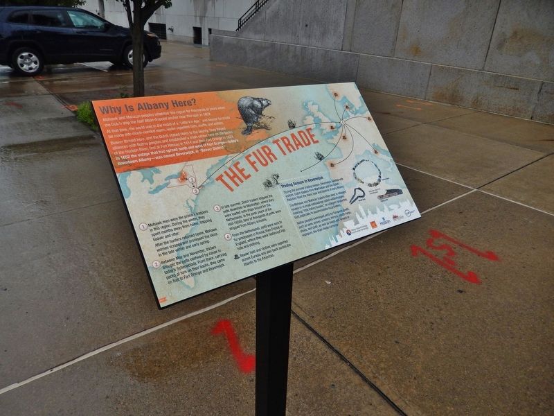
Mohawk and Mahican peoples inhabited this region for thousands of years when the Dutch ship the Half Moon dropped anchor near this spot in 1609.
At that time, the world was in the midst of a "Little Ice . . . — — Map (db m116700) HM
There is abundant evidence of Indian occupation on Peebles and Van Schaick Islands. Hammerstones and projectile points have been discovered and suggest that early tribes lived in this area. Archeologists uncovered a number of early hearths here . . . — — Map (db m115382) HM
In Colonial Times An
Indian Trail Ascended
The Helderberg Cliffs
At This Point From The
Lowlands To The East
State Ed Dept 1932
Friends of Thacher Park 2014
— — Map (db m77125) HM
Here in 1782 Major Moses Van Campen, a soldier of the Revolution, captured by the Senecas, keepers of the Western Door of the Iroquois Confederacy, ran the gauntlet thirty rods west to their ancient council house, which is now preserved in . . . — — Map (db m157328) HM
The last one of the Seneca Tribe of Indians that lived in the Town of Caneadea, N.Y. was buried here. His wife died some years before his death. He died March 23, 1864. He said he was 120 years old. — — Map (db m155771) HM
1627 Seneca Oil Spring 1927 Forms the first chapter in the development of the petroleum industry in America - a gigantic world enterprise transforming modern life. 1627 Oil in American continent first recorded in this region by the Franciscan . . . — — Map (db m86604) HM
Grazing, wallowing, and other bison behaviors turn out to be beneficial for plants and animals.
As seen on "The Zoo!"
Keepers noticed that one of the zoo's bison calves developed a bowed leg, caused by one leg bone growing faster than . . . — — Map (db m193265) HM
The lower Hudson Valley and the Bronx Terminal Market share a rich and colorful past.
Macomb's Dam Across the Harlem River
In 1814, Robert Macomb built a dam and toll bridge across the Harlem River in the vicinity of . . . — — Map (db m241545) HM
Located at the convergence of the Chenango and Susquehanna Rivers, Confluence Park is the hub of the Two Rivers Greenway and a meeting of Binghamton’s past and present.
[captions] The South Washington Street Bridge, shown here, was designed by . . . — — Map (db m198124) HM
This park capitalizes on the natural beauty of the Susquehanna and Chenango Rivers, maintaining a strong vista of the river confluence. The hub of a network of Binghamton's riverfront greenways, the park was planned to provide safe public access to . . . — — Map (db m198126) HM
Indian Castle
Located near junction of
Castle Creek with Chenango
River. Called Otsiningo.
Destroyed Aug. 18, 1779
during Sullivan Campaign — — Map (db m93030) HM
Near This Point 18 August 1779
Camped the army of James Clinton en
route to join the forces of General John
Sullivan in the expedition against the Iroquois and their British allies in the war of
the American Revolution
Originally erected by . . . — — Map (db m92920) HM
A museum exhibit interprets the Sullivan-Clinton Campaign of 1779. The campaign destroyed Native American villages and crops throughout the Iroquois homeland. — — Map (db m94628) HM
Routes of the Armies of General John Sullivan and General James Clinton 1779
An expedition against the hostile Indian nations which checked the aggressions of the English and Indians on the frontiers of New York and Pennsylvania, extending . . . — — Map (db m93324) HM
The valleys of the Upper Susquehanna River were natural routes for Indians, traders and settlers. Oquaga, near Windsor, was an Indian fur-trading post, and became an objective of the Sullivan-Clinton Campaign of 1779. From a dam at the outlet of . . . — — Map (db m35164) HM
This Boulder Marks The
Fort Stanwix Treaty Line
The deed from the Indians to the whites
was signed November,5 1768
The line was run in 1769
from the Delaware River almost due north
to the mouth of the Unadilla River
It afterward became the . . . — — Map (db m92769) HM
Native American village near mouth of Big Choconut Creek. Destroyed by General Enoch Poor August 18, 1779, Clinton-Sullivan Campaign. — — Map (db m127570) HM
First People in the Valley
The earliest inhabitants of this Susquehanna River valley were here more than 400 years ago. A 1614 map drawn by Dutch traders shows the existence of a village spelled Ogehage. Over time- and many different . . . — — Map (db m94489) HM
In Memory of "Wausaunia" Rebecca Kellogg Ashley
Born Dec. 22, 1695, in Suffield, Mass.
Died Aug 1757, Windsor N.Y.
Interpreter for the Indians at the "Old Fort," a mission station in charge of Rev. Gideon Hawley in 1748. — — Map (db m94536) HM
Welcome to Thunder Rocks The Legend of Thunder Rocks A local legend describes a competition among the guardian spirits of rocks to determine which spirit could throw the biggest rock to the top of the mountain. A nearby Iroquois tribe, after . . . — — Map (db m155618) HM
The Allegany Courthouse served as the primary gathering place for regular meetings of the Seneca Council, beginning in 1920. Over the next forty years, the Allegany Courthouse served as the governmental center of the Seneca Nation. During this time, . . . — — Map (db m217368) HM
Erie Indians were the first inhabitants of this region. In 1654, they were driven out by the Senecas who occupied several sites along the banks of Cattaraugus Creek. The Cattaraugus, the principal stream of many that divide the Cattaraugus Hills, . . . — — Map (db m86681) HM
Routes of the Armies of General John Sullivan and General James Clinton. 1779. An expedition against the hostile Indian Nations which checked aggressions of the English and Indians on the frontiers of New York and Pennsylvania, . . . — — Map (db m229007) HM
Early Iroquois country 1768.
Part of Montgomery Co. 1784.
Part of Herkimer Co. 1791.
Part of Onondaga Co. 1794
Cayuga Co. set off 1799 — — Map (db m229218) HM
A village of the Cayuga Nation,
stood near this spot. It was occupied and
destroyed by a detachment from the army
of General John Sullivan, commanded by
Lieut-Col. William Butler, which bivouacked
here on the night of September 21, . . . — — Map (db m145819) HM
This valley was the site
of the principal
Cayuga Indian village
To the brave French Jesuit
missionaries whose heroism
was almost without parallel
Joseph Chaumonot
and Rene Menard
who as guests as of
Chief Saonchiogwa
built here in 1656 . . . — — Map (db m145842) HM
front face
An expedition against the hostile Indian nations which checked the aggressions of the English and Indians on the frontiers of New York and Pennsylvania, extending westward the dominion of the United States.
rear face . . . — — Map (db m145834) HM
Owasco Flats
Site of Indian Village.
Land Cultivated Prior to
White Settlements.
Neighboring Settlers Came
to Harvest Hay 1789 - 1790 — — Map (db m213823) HM
This wooden sculpture of an American Indian
was created by Peter Toth of Akron, Ohio. In
two months time during the summer of 1973.
It was carved from the lower trunk of a
dead elm tree located near the corner of
Fifth St.and Park Ave. Upon . . . — — Map (db m162035) HM
The Land Around Us Farmhouse/Settlement Courtesy: Fenton History Center, Jamestown, N.Y. By the end of the 1700's the Holland Land Company was operating in western New York, including Chautauqua County. The first permanent European . . . — — Map (db m117555) HM
What Does "Chautauqua" Mean? Chautauqua Institution Courtesy: Fenton History Center, Jamestown, N.Y. The term "Chautauqua" has come to be associated with the Chautauqua Movement which grew from the county's own Chautauqua Institution. The . . . — — Map (db m117561) HM
First non-Indian settler of Hanover and Chautauqua County, built his home nearby in 1796. Indian friend, farmer, fiddler, and worker on the HLC survey. — — Map (db m64673) HM
Before white men came to this area the Indians blazed a trail between Lake Erie and Lake Chautauqua over which they, early explorers and settlers, portaged their canoes. At the Chadakoin River rapids the canoe was portaged again. Here is where the . . . — — Map (db m64674) HM
Indian Camp Part of the Cornplanter band of Seneca Indians camped on this hillside and adjoining river terrace in the period between the Indians' sale of their land in 1797 and their final retreat to reservations in the 1830's. — — Map (db m94806) HM
Chautauqua Lake, eighteen miles long and one to three miles wide, has as its outlet a branch of Connewango Creek, a tributary of the Allegheny River. This gives Chautauqua an indirect connection with the Gulf of Mexico by way of the Ohio, and . . . — — Map (db m64687) HM
Waterways to the Interior
Rivers and lakes served as the superhighways of the 18th century. Many rivers and lakes in the Colony of New York either bordered New France (Canada), or connected the bordering water bodies to the . . . — — Map (db m201458) HM
General Sullivan's troops were attacked by Indians posted on this ridge. A valorous charge led by Colonel Hubley drove the Indians to the swamp a quarter mile west. The American dead were conveyed to Tioga and buried at Fort Sullivan.
(Reverse . . . — — Map (db m66976) HM
Generals John Sullivan and James Clinton were appointed by George Washington to lead a punitive expedition against the hostile tribes of the Iroquois Confederacy and to capture the British forts at Oswego and Niagara. The objectives were to . . . — — Map (db m198208) HM
The Delaware village near this site included 30 to 40 buildings and farm fields burned by Continental troops on August 13, 1779. — — Map (db m242356) HM
The Revolutionary War divided communities and shattered ancient alliances. Along New York's frontier, simmering rivalries among settlers of European descent boiled over with threats and violent clashes. Many who remained loyal to King George III . . . — — Map (db m33553) HM
In 1778, the British government encouraged loyal colonists and Native American allies to attack frontier settlements. In July, Major John Butler led an attack on the Wyoming Valley, leaving more than 300 patriot soldiers dead, and by Butler's . . . — — Map (db m33548) HM
In 1879, a crowd of thousands celebrated the 100th anniversary of the Battle of Newtown and dedicated a monument built by the Newtown Monument Association atop the hill that figured prominently in accounts of the battle. Soon after, the monument . . . — — Map (db m33484) HM
The climactic battle of the Sullivan-Clinton campaign occurred here as approximately 5,000 soldiers defeated a British force of Native Americans, Loyalists, and regulars. — — Map (db m33545) HM
Delaware Captain who, with 20-40 Delaware men, defended their homes and land here on August 13, 1779 at the Battle of Chemung. — — Map (db m242357) HM WM
To protect the village of Newtown, about 600 Native American warriors, 200 loyalists, and a handful of British soldiers erected and camouflaged a half-mile-long breastwork of logs in the village overlooking a creek, hoping to surprise Sullivan's . . . — — Map (db m33550) HM
(Front Plaque):Near this site Sunday August 29, 1779 was fought The Battle of Newtown between Continental troops commanded by Major General John Sullivan and combined force of Tories and Indians under Colonel John Butler and Joseph . . . — — Map (db m33554) HM
Congress and General George Washington planned a major offensive campaign against the Seneca, Cayuga, and loyalists in 1779. Washington chose Major General John Sullivan to lead the expedition up the Susquehanna River, while Brigadier General . . . — — Map (db m33547) HM
In 1779 near this spot
General John Sullivan
mercifully disposed of his pack horses
worn out by faithful service
in the campaign against the
Six Nations of the Iroquois.
——————
The first white . . . — — Map (db m90382) HM
On September 24, 1779, General Sullivan's military park horses, returning through the valley from their 450 mile journey, had reached the end of their endurance. The General was compelled to dispose of these partners in the cause of American . . . — — Map (db m90386) HM
An expedition against the hostile Indian nations which checked the aggressions of the English and Indians on the frontiers of New York and Pennsylvania, extending westward the dominion of the United States. — — Map (db m90383) HM
From this Hidden Stronghold British, Indians and Tories Ravaged the Frontier From the West Branch to the Mohawk Destroyed by Sullivan-Clinton Expedition August 13, 1779 — — Map (db m81210) HM
The 1779 campaign drove
native peoples from their
villages. Seneca and Delaware
fought to protect their
family, homes and way of life. — — Map (db m243110) HM
The Seneca and Delaware urged
British allies to help block
Continental troops advance
resulting in Battle of
Newtown on August 29, 1779. — — Map (db m243111) HM
On the pinnacle near this site, the Movable Lodge of Free Masons, connected with the army of
Major General John Sullivan
of New Hampshire
held a command under a large oak tree, while on a military expedition against the Six Nations of . . . — — Map (db m220541) HM
Routes of the Armies of
General John Sullivan
and General
James Clinton
1779
An expedition against the hostile Indian nations which checked the aggressions of the English and Indians on the frontiers of New York and Pennsylvania, extending . . . — — Map (db m92996) HM
Indians living in the valleys of the Unadilla and Susquehanna Rivers played an important role in the region's early history. Fur traders from Albany and the Mohawk Valley reached out to Oquaga (now Windsor), and a mission to the Indians was . . . — — Map (db m93549) HM
Routes of the Armies of
General John Sullivan
and
General James Clinton
1779
An expedition against the hostile Indian nations which checked the aggressions of the English and Indians on the frontiers of New York and Pennsylvania, extending . . . — — Map (db m92998) HM
Beautiful Indian maiden and her lover from opposing nation rests beneath this rock. When church bell rings, rock turns over, lovers appear. — — Map (db m129044) HM
725 entries matched your criteria. The first 100 are listed above. Next 100 ⊳