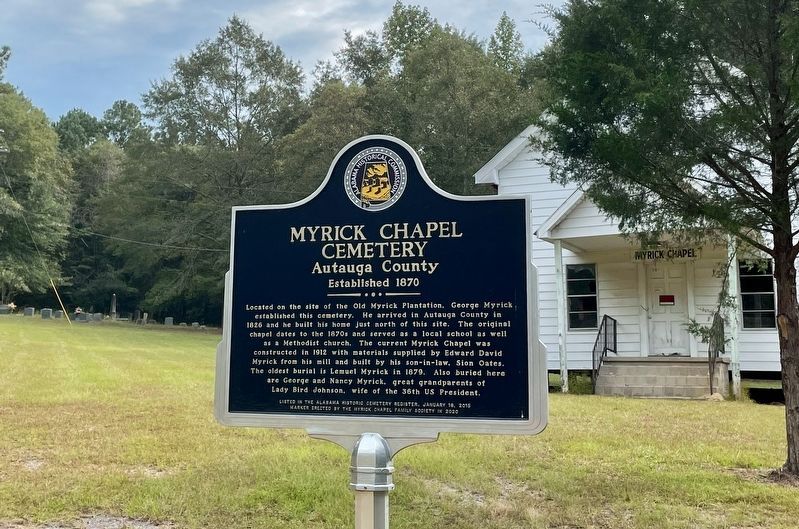
Located on the site of the Old Myrick Plantation, George Myrick
established this cemetery. He arrived in Autauga County in
1826 and he built his home just north of this site. The original
chapel dates to the 1870s and served as a local school as . . . — — Map (db m206686) HM
(Front): Daniel Pratt CemeteryFinal resting place of early Alabama industrialist Daniel Pratt, 1799-1873, and wife Esther Ticknor Pratt, 1803-1875. He was from New Hampshire and she, Connecticut. Married 1827 at Fortville, Jones County, . . . — — Map (db m168941) HM
This cemetery is one of the oldest cemeteries in Autauga County having been established as a burial ground by at least 1841. The land was officially set aside as a burial ground when the county seat was in this area from 1834 to 1868. The area . . . — — Map (db m82561) HM
Rocky Mount Cemetery was established on this sacred ground for families who settled Cobb’s Ford and the surrounding area. The oldest marked burials date to the 1890s. Numerous veterans of the Civil War and World Wars I and II are buried here. Rocky . . . — — Map (db m158661) HM
In 1870, Marbury Lumber Company donated land for the White Pond Methodist Church and Cemetery. It is believed that the first burial in the cemetery, marked only by a pile of bricks, took place that same year. The earliest marked grave is of Thomas . . . — — Map (db m158662) HM
Colonia Italiana 1888-The Beautiful Forest
In 1888, Alesandro Mastro-Valerio, realizing the plight of fellow Italian immigrants living and working in hazardous conditions in many northern states, bought land here to attract colonists. He . . . — — Map (db m130913) HM
The Grand Hotel and the Gunnison House served as a hospital for wounded Confederate soldiers from the Battle of Vicksburg during the Civil War. The Confederate Rest Cemetery commemorates more than 300 Confederate soldiers who died while in the . . . — — Map (db m153433) HM
(front)
The property where the cemetery is located was part of a Spanish Land Grant issued to the Suarez family prior to the War of 1812. In 1925, a United States Land Patent was confirmed and issued. The property has been in use since . . . — — Map (db m71618) HM
During the Revolutionary War, France, Spain, Britain, and the United States were interested in the fate of this region. In March 1780, Spanish forces captured Mobile. They established a palisaded fort with trenches (one mile north of here) to . . . — — Map (db m61451) HM
Saluda Hill Cemetery is a private historical cemetery established in 1824. Among the graves here is that of Zachariah Godbold, the only known Revolutionary War veteran buried in Baldwin County. Many Blakeley residents and Confederate soldiers also . . . — — Map (db m81854) HM
Side 1
In 1828, Reverend John Wesley Norton left his native South Carolina with his family and a wagon train of followers, crossed into the Creek Indian Nation and just into the edge of what was then Pike County, settling near the . . . — — Map (db m78123) HM
Organized and constituted April 11, 1835. A committee called brethren John Tew and Solomon Sikes as presbyters. The presbyters, finding the brethren orthodox in faith, constituted a church which they named Bethel. Founders migrated from Pa., N. C.. . . . — — Map (db m220893) HM
To the memory of the African slaves who lived, worked, worshipped and died here at April, 1857. These 23 were baptized members of the Pea River Presbyterian Church
Moses · Dilley · Hanner
Mary · Calvin · Sarah
Henry · Anakey · Hannah . . . — — Map (db m187391) HM
This cemetery is the final resting place for many early pioneers who settled this area of Alabama. More than six generations of families from the surrounding communities including county elected officials, mayors of both Louisville and Clio, . . . — — Map (db m187390) HM
Side 1
Fairview contains a diverse collection of statuary, grave emblems and monuments amid a picturesque park-like setting. Many monuments are attributed
to the Tansey family who owned a monument company in Eufaula and operated their marble . . . — — Map (db m173638) HM
Interred on this gently sloping hillside are the remains of many of Eufaula’s early black citizens. Their names are known only to God because the wooden grave markers which located the burials have long since vanished. This burying ground was used . . . — — Map (db m27987) HM
Constructed in the 1840s and constituted in 1852, Ramah Baptist
Church is in the community formerly known as both Ramah and
Vaughn. Records show that the land for both the church and
cemetery was given by Solomon G. and Francis T. Burke in . . . — — Map (db m158553) HM
This Greek Revival church was built in 1841 by John Fletcher Comer with lumber from his mill. The building originally had a slave balcony and exterior stairway which were removed c. 1890. At the same time, the pulpit was moved from between the two . . . — — Map (db m188268) HM
Centreville Cemetery is older than the town of Centreville itself. The earliest known burial is that of Willie Coleman, dated 1822, and Centreville was established in 1823. One half of the cemetery, known as Cooper Cemetery, contains mostly the . . . — — Map (db m156403) HM
Antioch (an'~te~ok') was an ancient Biblical city and a chief center of early Christianity. Today, many churches and cemeteries throughout the United States use the name. Once called Glover's Graveyard, the earliest recorded burial is 1794. Antioch . . . — — Map (db m128071) HM
The town of Aberfoil was incorporated January 26, 1839, in then Macon County, with the first election for councilors conducted and managed by Lewis Stoudenmire, Charles G. Lynch, Thomas Scott, David Hudson, and A. J. and E. A. Jackson. Aberfoil was . . . — — Map (db m61027) HM
Samuel Sellers (1788-1857) of North Carolina arrived with his large family at Three Notch Road on January 29, 1835. Here, in what was then the Missouri Beat, Pike County, the first post office in the area was established, 2.5 miles west of . . . — — Map (db m61061) HM
Log Cabin Museum
Early settlers of this area cleared land and built their first homes of logs in the early 1830s. This cabin was built by Reuben Rice Kirkland (1829-1915) about 1850. He and his first wife had ten children while living in the . . . — — Map (db m60969) HM
A 19th century cultural center located on the ridge dividing the coastal plain from the black belt originally Pike Co., Al.; Bullock Co. since 1866
Cemetery established in the 1830s for all faiths, situated between Mt. Hilliard Methodist . . . — — Map (db m181649) HM
(side 1)
Settlers from the Edgefield District, South Carolina, organized the Sardis Baptist Church on June 10, 1837. The first building, a log cabin, was constructed in 1841 after John M. and his wife Amy Youngblood Dozier deeded four and . . . — — Map (db m67552) HM
In March 1863 Francis and Sarah Sheppard gave 3 acres of land to Methodist Episcopal Church South as a place for worship and burial. 2 more acres given by Alexander and Mary Sheppard Oct. 1868. Property sold to County Line Primitive Baptist Church . . . — — Map (db m70838) HM
Greenville's oldest, established 1819. Captain William Butler, for whom the county was named, buried here. He was killed fighting Indians led by Savannah Jack in March, 1818. Greenville's oldest church, a community church established in 1822, . . . — — Map (db m70751) HM
James Crook established this cemetery in
1837 on land he purchased from Creek
Indians. In 1834, he and his family moved
to this area from South Carolina.
In Nov. 1837, Samuel M. Crook, grandson
of James Crook, was the first person buried
here. . . . — — Map (db m36552) HM
Located at the end of McKibbon Street is on a cedar covered hill with a beautiful view. The cemetery contains the remains of many of Oxford's early settlers. Some markers date in the 1850's. — — Map (db m195727) HM
In 1885, Five Points was named because of five roads converging at a single point. Before this, the post office was known as Lystra, operated by Postmaster W.C. Smith. The town was incorporated in 1915, making the town Chambers County's oldest . . . — — Map (db m195788) HM
Elisha and Essie Handy came to La Fayette in 1925. They were
educators and active in civic and religious activities. In 1940 their
oldest son, Ralph, died from tuberculosis and was buried in the
only cemetery in La Fayette for African-Americans . . . — — Map (db m151220) HM
LaFayette Cemetery, also known as Westview, began in 1934 with the death of Miss Sarah Gipson. Many early pioneers and veterans of East Alabama are buried here including Revolutionary War Patriot Capt. Alexander Dunn, Col. Charles McLemore, . . . — — Map (db m83263) HM
Final resting place of Chief Pathkiller (B. 1749 - D. 1827) who served as principal chief of the Cherokee Nation. Many prominent early settlers are also interred here including newspaper editor and publisher, Confederate infantry captain and . . . — — Map (db m114282) HM
Last fighting between armies of Hood and Sherman. Here Ferguson turned back Kilpatrick's larger force.
These two armies had fought all summer from Chattanooga to Atlanta, west to here.
To split South, Sherman turned, led Union forces . . . — — Map (db m132782) HM
Completed in 1904, this is one of only three remaining sections of the original woven wire fence at the Soldiers' Home.
During the latter half of the nineteenth century woven wire and barbed wire began to replace wooden rail fences.
Woven . . . — — Map (db m129332) HM
Completed in 1904, this is one of only three remaining sections of the original woven wire fence at the Soldiers' Home.
During the latter half of the nineteenth century woven wire and barbed wire began to replace wooden rail fences.
Woven . . . — — Map (db m129425) HM
In 1896 Swedish settlers organized the Concordia Methodist Church and acquired this land for the Concordia Cemetery, later known as the Lutheran Cemetery. This is the former site of Strassburg School. In the 1980s it became known as the Scandinavian . . . — — Map (db m83269) HM
This cemetery is the final resting place for thirty-seven
members of the Moore Family. John Moore, son of American
Revolutionary War Patriot and Battle of Charleston POW
Obadiah Moore, purchased this land on September 4, 1834.
The Moore family . . . — — Map (db m206684) HM
The Sims Cemetery is located just south of this marker. Buried there, is the infamous Robert B. "Bob" Sims (1831-1891). From the early 1870s to 1891, Bob and his band of followers carried out a virtual reign of terror in central and southern . . . — — Map (db m240485) HM
Little Place Cemetery
Little Place Cemetery is a community cemetery that serves the African American Womack Hill community and its descendants. The establishment of the cemetery is linked to the founding of Mt. Pleasant Baptist Church, . . . — — Map (db m240385) HM
In 1871, Springhill Missionary Baptist Church was established. In 1875, William Johnson Sr. donated the land for the Springhill Missionary Baptist Church and Cemetery on Ararat Road. During the same year, work began on a permanent church building . . . — — Map (db m240457) HM
Listed on the National Register of Historic Places, the Mt. Nebo Cemetery is home to the unique folk art of African American inventor and artist, Issac "Ike" Nettles, who used concrete to make images of living people's faces for their . . . — — Map (db m101576) HM
Near this site, is the gravesite of Maj. Jeremiah Austill, folk hero & prominent figure in the early settlement of Clarke County. Born in 1794 in S. C., he lived, along with his parents, Capt. Evan and Sara Austill, among the Cherokee in Ga. . . . — — Map (db m101588) HM
Front:
This Greek Revival style brick structure is known as the Hope Family Grave Shelter. Constructed in 1853, it is listed on the National Register of Historical places. The unusual splayed eaves and vaulted or “compass” . . . — — Map (db m47621) HM
Established 1858, ¼ mile east of here. Camp meetings were held in summers. Congregation moved to site near Peniel 1894. The "arbor" and church building were left at original site. These buildings convenient for annual encampment of county . . . — — Map (db m101579) HM
The first burial here was James Shorter Grimes who died May 20, 1903, at the age of 48. His wife, Malissia Tillis, and 9 of their 14 children are also buried here. Their son, John Temple Grimes, along with M.G. Caylor and A.D. Donaldson purchased a . . . — — Map (db m231394) HM
Established 1858 Oldest official record is land deed
of December 29, 1853 for five acres to trustees I.T.
Law, William Mixson, William Dubose, Javor Dupee
and William Hendricks. Name was changed in 1868 to
Old Tabernacle after New Tabernacle . . . — — Map (db m204960) HM
Bullet - marked tombstones in this cemetery show evidence of a brisk skirmish here Oct. 26, 1863, when Gen. P.J. Osterhaus's first division of Sherman's Corps came under fire from Gen. S.D. Lee's Confederate troops. CSA artillery on a hill near a . . . — — Map (db m83329) HM
Chickasaw Indian removal began in July 1837. This removal allowed white settlers to establish residence in Colbert County.
One example of this is the Mhoon family who migrated from Halifax County, North Carolina in June 1837.
They built their . . . — — Map (db m244515) HM
Old Brick Church began in 1820 as the Mt. Pleasant Cumberland Presbyterian Church and met in a frame building which burned in 1824. The present building has undergone few changes since its construction in 1828 when the congregation was officially . . . — — Map (db m147370) HM
(side 1)
The town of Leighton was named in honor of the Reverend William Leigh, son and grandson of Revolutionary War veterans. He was born in Amelia County Virginia, Oct 4, 1790 and moved to Alabama about 1823. Leigh settled nearby . . . — — Map (db m106112) HM
Dedicated to Civilian defense workers in critical industry for the war. US Army directed construction and production via Air Nitrate Corp. Army Projects here in 1917-1918 required 20,000 workers recruited from across the USA. The great flu-pandemic . . . — — Map (db m138776) HM WM
This burial ground was designated on General John Coffee's 1817 survey and original map "Plan of a Town at the Coldwater Spring." The oldest tombstone carries the burial date 1821 and the cemetery contains graves of veterans from all wars beginning . . . — — Map (db m28567) HM
The Winston family settled this area in the early 1820s. Andrew Jackson purchased the property at the U.S. government land sale and conveyed it to Col. Anthony Winston (1782-1841) who lived nearby in a two-story brick Federal-style house (razed . . . — — Map (db m28566) HM
War of 1812 veteran John Green (1790-1882) settled in Burnt Corn in 1816. He held many public offices, established the first school, and represented Conecuh County in the state legislature in 1824 and 1829. He was the Conecuh delegate to the . . . — — Map (db m81285) HM
Peace & Goodwill Cemetery is Coosa County's first African American Cemetery to be placed on the prestigious Alabama Historic Cemetery Register. It provides powerful insights about the diligence and commitment of our African Ancestors. Family . . . — — Map (db m64587) HM
The Rutledge Primitive Baptist Church was built circa 1890, on land donated by Thomas Warren Shows and his family. The Rutledge Primitive Baptist Church was a member of the Ebenezer Primitive Baptist Association, which was formed in 1837. It was one . . . — — Map (db m72054) HM
Col. John G. Cullmann
July 2, 1823 - December 3, 1895
Thrifty German Colonists led by Col. John G. Cullmann in 1873 settled this thinly populated plateau of Alabama.
— — Map (db m35629) HM
The first family to settle this area in 1832. Married Nancy Stewart Hanby, daughter of Gabriel Hanby, who was one of the original framers of the Alabama Constitution. They became parents of 11 children: 4 sons served in the Confederate Army. At one . . . — — Map (db m201371) HM
Marked by an antique arch, the Holly Pond Cemetery encompasses 10 acres and a chapel built in 1975. The site was chosen to replace the burial ground in the center of town and make room for the town to grow. The first acre was deeded to the deacons . . . — — Map (db m160676) HM
Early settlers to Cullman County established Shady Grove Methodist Episcopal Church as a brush arbor in the 1870s on land homesteaded and donated by Richard McCain. Trustees, J. J. McKissack, W. H. Martin, J. C. Vickery, J. W. Kilgo, together with . . . — — Map (db m34244) HM
Founded by the Keahey family and related immigrants from Scotland, the adjacent Union Presbyterian Church established this cemetery before the Civil War. The Presbytery of South Alabama, a District Governing Body of the Presbyterian Church . . . — — Map (db m183624) HM
The Christian Hill Congregational Church was established by the Rev. Samuel Long in 1895. After serving the community for more than 50 years, the church was inactivated and the building dismantled in the early 1970's. — — Map (db m205354) HM
In loving memory of Clarence Dowling Barnard founder of the Claybank Memorial Association for the perpetual care of the Claybank Cemetery 1963 — — Map (db m213373) HM
Restored to its original pioneer condition in 1980 by descendants of
William A. "Billy" Byrd
1850-1931
and wife Ophelia Dowling Byrd
1854-1931
This is to certify that Claybank Log Church which has been selected as a landmark . . . — — Map (db m213406) HM
Longstreet Cemetery contains six separate cemeteries that were moved to this location in August 1942 during the construction of Fort Rucker. The property where the cemeteries are now located was the former site of Longstreet School. Cemeteries moved . . . — — Map (db m181072) HM
This Church was organized August 3,1868, under a brush arbor, by Elias John McLendon and John Bradley.The first building was log house near the cemetery west of the Edd Dykes's place. First known as "Antioch" the church was later named Salem. On . . . — — Map (db m182138) HM
Created by the Legislature
This cemetery was created by an act of
Alabama's Legislature on January 31,
1852. Cahaba's town council selected
this spot, but the Legislature had to
confirm their choice because all public
land within . . . — — Map (db m150864) HM
These are not graves.
These are markers to memoralize
the Federal soldiers who died in the
Cahawba Military Prison during the
Civil War. The men within the prison
called it "Castle Morgan."
No one knows where in Cahawba these . . . — — Map (db m112409) HM
Burials in this cemetery, which served Cahaba from 1848 to 1900, tell a story of the town in which many deaths resulted from diseases of infancy, childhood and early adult life, Yellow Fever being a large factor because of proximity to Gulf of . . . — — Map (db m23322) HM
This site was set aside by the 1820 General Assembly, burials here date from 1818 to 1847. Interred are some of the state's earliest figures. There is no record of names, many handsome tombs have been destroyed, seven marked ones remaining, six are . . . — — Map (db m23355) HM
Prosperity Associate Reformed Presbyterian
Church Cemetery is the resting place of many
members of the church from 1846 until 1961. The
Church was organized in 1822 by Isaac Grier. A
church building stood on this site from 1844 until
1891, . . . — — Map (db m112357) HM
A Cumberland Presbyterian church named Mt. Pleasant was organized here about 1821 by Rev. William James Moor, a missionary from the Elk Presbytery of Tennessee. Renamed Mount Carmel in 1827, this church provided early leadership for the Ala. . . . — — Map (db m75777) HM
East portion reserved for graveyard, 1829; west part purchased City of Selma, 1877.
Here are buried:
William Rufus King, 1786-1853, Vice President of U.S. 1853.
John Tyler Morgan, 1824-1907, U.S. Senator, Brig. Gen. C.S.A.
Edmund . . . — — Map (db m37653) HM
Established in 1816 by eight families from Rocky River Presbyterian Church in Mecklenburg County, North Carolina.
In 1859 this two-story brick building replaced original wooden structure.
Sanctuary and former slave gallery are on second . . . — — Map (db m83683) HM
Native Sampson County, North Carolina.
Admitted to bar, 1806.
North Carolina House of Commons 1807-1809.
U.S. Congressman 1811-16.
Secretary U.S. Legation Naples and St. Petersburg 1816-1818.
Moved to Dallas County, Alabama, 1818.
. . . — — Map (db m37654) HM
Established circa 1819 as Childers Meeting House on land given by George Childers. Patent for the land was issued to George Childers March 16, 1819. This Methodist Church was later known as Childers Chapel. Church burned in 1842. Congregation . . . — — Map (db m37646) HM
Franklin Cemetery was established in the mid-nineteenth
century and was originally located on land where the existing
Georgia-Pacific Brewton LLC containerboard mill stands off of
Highway 31 in Brewton. The cemetery served as the primary
burial . . . — — Map (db m94163) HM
This cemetery was established in 1854 when Pilgrims' Rest Baptist Church was founded across the road on September 17 in that same year. The cemetery remained prominent in Alco even though the original congregation moved and Alco Methodist Church . . . — — Map (db m130672) HM
Union Cemetery has been an
important resting place for
Brewton's loved ones since
at least 1879. State
officials acknowledged
the historical significance
of Union Cemetery for our
area by adding it to the
Alabama Historic Cemetery
Register . . . — — Map (db m94162) HM
Established in 1826 as "The Colored Cemetery," this site is
the first and largest African-American cemetery in Gadsden.
In 1918, the Mosaic Templars of America, a fraternal
organization who provided African Americans with death and
burial . . . — — Map (db m167227) HM
Oldest church in Etowah County. Organized Saturday, April 2, 1831, at Harmony Meeting
House, which was built in 1821, by Edmond Jones at this location.
It was here that the Wills Creek Baptist Association was organized in 1836, Harmony
being . . . — — Map (db m205239) HM
In the summer of 1784 William Jones and his two young sons were among a group of families from Georgia making their way through this area following the Old High Town Path. They camped here near a large spring and planned to continue their journey . . . — — Map (db m156371) HM
The lone survivor being Edmond Jones, 5 year old son of William and Hannah Humphries Jones, who later gave the land for the cemetery. — — Map (db m156398) HM
Organized on June 30, 1888 by thirteen charter members as Dundee Missionary Baptist Church. The congregation originally worshipped in a brush arbor on this present site. The first church building was erected from pine slabs in the summer of 1886. . . . — — Map (db m39125) HM
The Countyline Missionary Baptist Church and adjoining cemetery were established in November 1882, on land donated by Shade Adams, Originally donated by way of a gentleman's agreement with the founding members, the land was deeded to the 'Countyline . . . — — Map (db m199425) HM
Side 1
The First Baptist Church of Abbeville
This church was founded in 1834 as a mission of the Lawrenceville Baptist Church. Reverend Jeremiah Campbell was one of the early pastors. Later meetings were held in the lower story . . . — — Map (db m71807) HM
Constituted to the Glory of God, circa 1871, by former slaves in the area that later became Halesburg (now Haleburg), Alabama in 1885. Mt. Zion Church is one of the oldest African-American wooden frame churches in service in Alabama's Wiregrass . . . — — Map (db m165975) HM
Side 1
An arm of the Shilo Primitive Baptist Church located near the Abby Creek, began meeting near the Three Cornered Pond just south of here in 1848. A new church called Piney Grove was constituted on April 21, 1849, by the hands of . . . — — Map (db m71815) HM
Side 1
Newville Baptist Church
A small Baptist congregation met under a brush arbor in 1876, near what later became the village of Wells which grew into the town of Newville, Alabama. A log church called Center was erected in . . . — — Map (db m71814) HM
Old Center Methodist Church
The church was organized in 1859. The first building was a log structure located just NW of the present building. In the 1870's it was part of the Newton Circuit and was served by a minister who lived in the . . . — — Map (db m71831) HM
Union Springs Missionary Baptist Church was
dedicated to the Glory of God on September 19,
1896. Founders of the church included the Rev.
Zack Deese, George Murray, Nathan Jones, Alec
Cutchen, George Stokes, Marion Holland and Jasper
Roney. The . . . — — Map (db m174720) HM
306 entries matched your criteria. The first 100 are listed above. Next 100 ⊳