[Center and Main Marker:]
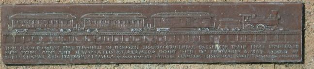
This plaque marks the terminus of the First Transcontinental Passenger train that started in New York City and terminated at Alameda Point Pier on September 6, 1869. Erected by the U.S. Naval Air . . . — — Map (db m150959) HM
On September 6, 1869 first Transcontinental
Railroad train linking two great oceans, and
consisting of twelve cars and three locomotives
passed here on way to a wharf terminal west
of here, a location now covered by lagoon
for take-off . . . — — Map (db m150265) HM
In 1918, the City of Alameda invested some of the profits from its Municipal Lighting
Plant in a railroad. The "belt line,” so called because it traveled around, rather than
into a city, ran 1.16 miles along Clement Avenue from Pearl Street . . . — — Map (db m157021) HM
Before the Ice Age waned about 10,000 years ago, this area was part of a wide valley
through which the Sacramento River flowed on its way to the Pacific Ocean near the
Farallon Islands. The river spilled over a waterfall at the Golden Gate . . . — — Map (db m174544) HM
City of Berkeley Landmark
designated in 1978
James Loring Baker was an early Berkeley landowner, developer, and civic leader. He was one of the signers of the incorporation papers for the Town of Berkeley and it was he who delivered them to . . . — — Map (db m54332) HM
Stone and Smith, Architects 1901
Jim Novosel: The Bay Architects 1998
Berkeley’s transit pattern was established in 1876 when Francis Kittredge Shattuck and James L. Barker brought a spur line of the Central Pacific (later Southern Pacific) . . . — — Map (db m52378) HM
City of Berkeley Landmark
designated in 1998
By 1900, downtown Berkeley had developed around Shattuck Avenue, its main street. On this site, owned by John Hinkel, stood a brick livery stable run by John Fitzpatrick, the early operator of the . . . — — Map (db m54346) HM
From 1902 to 1979 the Santa Fe railroad company used this land for both industrial shipping and passenger
service. The railroad tracks that once passed through here were part of a nine mile strip of land that went from
Richmond to Oakland. After . . . — — Map (db m153776) HM
City of Berkeley Landmark
designated in 2001
During the early 20th century, the Santa Fe Railroad provided three-day passenger and freight service between Chicago and the Bay Area. This depot was one of three major rail stations in Berkeley. . . . — — Map (db m53828) HM
This building was originally part of the small commercial district that grew up around Dwight Way Station where Shattuck Avenue commuter trains intersected with the horse-car line that ran up Dwight Way to the California Schools for the Deaf and . . . — — Map (db m29581) HM
From the early 1930's the Santa Fe railroad tracks
ran along Sacramento Street in South Berkeley,
through the heart of the African-American community.
This was unsafe and a barrier to unifying
the Berkeley community.
In 1978 Dr. William B. . . . — — Map (db m171589) HM
South Berkeley was originally settled by Coast
Indians. After Spanish conquest in the 1700s, large
land tracts were held by the Peralta, Ashby and
Harmon families.
Transportation has been a key factor in Lorin's
history. Gov. Stanford . . . — — Map (db m145998) HM
Tassajara Creek Regional Trail
Tassajara Creek/Ridge Trail
(5.54 Miles): This unpaved and paved regional trail extends from the lowlands of Tassajara Creek in Alameda County to the ridgeline above Dougherty Valley in Contra Costa . . . — — Map (db m204577) HM
A 3 foot narrow gauge railroad starting on land owned by Joseph E. Emery, later president and founder of the City of Emeryville.
The line started at 40th and San Pablo, extended through Berkeley and up San Pablo Creek to Bryant (Orinda) 23 . . . — — Map (db m72398) HM
When the first transcontinental railroad was completed in
1869, its route from Sacramento to Long Wharf in Oakland,
on the shore of San Francisco Bay, was circuitous. It went
south to Stockton and then west through Niles Canyon, about 25 miles . . . — — Map (db m239037) HM
In 1877, across the railroad tracks from here, Edward Wiard
built a dance pavilion on top of an ancient shell mound, either
oblivious to, or choosing to ignore, its cultural significance to
the indigenous people. Thus, Shell Mound Park was . . . — — Map (db m239056) HM
You are at the southern end of the Emeryville Greenway, a rails-to-trails project that converted a former interurban passenger and
freight rail line to a pedestrian and bicycle trail across Emeryville.
The Greenway was originally an . . . — — Map (db m238893) HM
Overview of History
California Nursery Historical Park is 20 acres of prime agricultural land. People who inhabited the area included the Muwekma Ohlone, Spanish (Mission San Jose), Mexicans (Rancho Arroyo de la Alameda), and “Californios.” . . . — — Map (db m208723) HM
This railroad station having been located about half a mile west of the old town of Laddsville, on land owned by Wm. M. Mendenhall. Established the location of the town Livermore. The first depot was a freight car that was soon replaced by a . . . — — Map (db m194530) HM
Western history owes the Carter Brothers a great debt, for they were the general contractors for the first six narrow gauge railroads in California. From 1874 to 1902 they built freight, passenger, cable and street cars. Their plant became Newark's . . . — — Map (db m94310) HM
“May God continue the unity of our country as this railroad unites the two great oceans of the world.” The gold spike ceremony at Promontory, Utah in May of 1869 united the tracks of the Central Pacific and Union Pacific Railroads. . . . — — Map (db m143737) HM
Imagine crossing the Bay before there
were bridges and trains. Boats were once
the only option.
In 1869, a ferry from a terminal near here finished the journey West for transcontinental railroad passengers.
In 1869, a ferry from a . . . — — Map (db m160324) HM
Moving Shoreline
Oakland's 19-mile shoreline underwent continual change after the Gold Rush, as marsh and tideland was reclaimed for development. The natural shoreline now lies buried under dredged bay sediments and landfill. Here, by the . . . — — Map (db m92753) HM
On a January morning in 1906, two hundred workmen from Western Pacific Railway and thirty armed “company soldiers” landed on the north training wall and began laying track. Although the City of Oakland had invited this action, it was . . . — — Map (db m72207) HM
Latham Square is actually a triangle, an accidental space created
by the meeting of new and old roads. Broadway did not extend
above 14th Street until the late 1880s, when it was needed to
channel the city's expansion to the north. Telegraph . . . — — Map (db m160466) HM
It is silent now, but long ago, you would hear the shrill scraping
of iron wheels along a track as a green Interurban electric train
would suddenly appear and pass along the very path on which
you are standing. From 1912 to 1957, the popular . . . — — Map (db m184320) HM
The Sausal Creek Arch Bridge, commonly known as the Leimert Bridge since its completion in 1926, is a graceful example of a fixed arch bridge. George Posey, Alameda County Surveyor and engineer of the Posey Tube connecting Alameda to Oakland, . . . — — Map (db m223950) HM
On this spot on June 1, 1904, the first Key Route electric train arrived to be welcomed by a crowd of excited residents. From a new ferry pier on the bay off Emeryville it had brought officials and guests to a dedication ceremony here. Key founder . . . — — Map (db m72279) HM
The railroad industry transformed Oakland from an oak forest to a thriving city. Rapid growth began when the Central Pacific Railroad absorbed local rail lines in 1868 and was granted right-of-way to build a freight and ferry pier. The Oakland Long . . . — — Map (db m19209) HM
Railroad Heritage
The opening of the transcontinental railroad in 1869 reduced travel time between the East and West Coats from as much as four months by sea to just six days. The Central Pacific made Oakland its western terminus. In 1871, . . . — — Map (db m71297) HM
First Western Pacific transcontinental passenger train drawn by Engine No. 94 arrived in Oakland via Scenic Feather River Route August 22, 1910. Famed California Zephyr began operation in 1949. Adapted to restaurant in 1975. — — Map (db m72109) HM
After winning a legal challenge to Southern Pacific Railroad's 50-year stranglehold on the
Oakland waterfront, Western Pacific Railroad Company inaugurated freight service in December 1909
and opened the Western Pacific Freight Office at Third and . . . — — Map (db m145512) HM
The name Trestle Glen dates back to 1893 when Francis Marion "Borax” Smith's Oakland Traction Company extended a trolley line from downtown Oakland, up Park Boulevard to Grosvenor
Place. From a point just above where Holman Road crosses Grosvenor . . . — — Map (db m185171) HM
Imagine! Right where you are standing one of the world's longest interurban electric railroads called the Sacramento Northern Railway once ran. Along 185 miles of track, it operated between Oakland and Chico from 1912 to 1957. Service on this line . . . — — Map (db m153763) HM
Where Rail, Road & Water Meet
The Waterfront Warehouse District developed as an intermodal distribution hub for the post, the railroads, and the local and regional roads. Coffee, rice, sugar, produce, meat, hides, burlap bags, paper, paint, . . . — — Map (db m228137) HM
Welcome to the Waterfront Warehouse District
For most of the 20th century Oakland’s Waterfront Warehouse District was a center for the collection and distribution of food products, capitalizing on Oakland’s strategic position as a center of . . . — — Map (db m228126) HM
Welcome to the Waterfront Warehouse District
For most of the 20th century Oakland’s Waterfront Warehouse District was a center for the collection and distribution of food products, capitalizing on Oakland’s strategic position as a center of . . . — — Map (db m228130) HM
Welcome to the Waterfront Warehouse District
For most of the 20th century Oakland’s Waterfront Warehouse District was a center for the collection and distribution of food products, capitalizing on Oakland’s strategic position as a center of . . . — — Map (db m228138) HM
The photo above overlays the 1909 Western Pacific Freight Depot in its original location, arguably the catalyst for developing the Waterfront Warehouse District as an intermodal Distribution hub.
After winning a legal challenge to Southern . . . — — Map (db m228122) HM
This depot was built in 1898 by Southern Pacific. Standing just east of the tracks off Davis St., it served San Leandro until passenger service was stopped. Donated to the S.L. Historical Railway Society, it was moved here and restored – 1988. — — Map (db m209197) HM
In 1869, the first Transcontinental Railroad passed this spot on its way to the shore of the San Francisco Bay. In 1984 the Southern Pacific Railroad abandoned this historic line between Niles and Tracy, California.
Volunteers of the Pacific . . . — — Map (db m63766) HM
About 200 yards offshore, in what was once Silver Valley lies the Reynold’s House. This house appears on an 1878 General Land Office map and was probably one of the many road houses along the route that catered to tourists and travelers. Reynold’s . . . — — Map (db m10999) HM
Named after Major John Ebbett and pointed out in 1853 to surveyor G.H. Goodard who referred to it as a “route of great promise – probably the best one for a transcontinental railway.”
No emigrant train used this route but a . . . — — Map (db m11444) HM
Old No. 7 was the last steam locomotive to operate over the Amador Central Railroad between Ione and Martell. The twelve mile long railroad lies entirely within Amador County and is one of the shortest railroads in this country. Iron Ivan is a fine . . . — — Map (db m2371) HM
Started about 100 years ago as Ryan’s Station. In 1888 became known as Martell’s Station. This was the main terminal for stagecoaches from Amador County gold mines. Large shipments of gold bullion were made from Martell’s Station to San Francisco, . . . — — Map (db m70230) HM
A man of tremendous ambition, Leland Stanford, Sr., was one of California’s most distinguished businessmen, politicians, philanthropists, and proponents of education. Lured to California by the Gold Rush in 1852, he became an owner of Sutter Creek’s . . . — — Map (db m12610) HM
In 1902, Diamond Match Co., established the Butte Co. Railroad. The So PAC tracks ran between Chico, Durham, and Stirling City. Regular train service between Chico and Magalia began Nov. 2, 1903. Magalia depot was completed soon thereafter. April 8, . . . — — Map (db m61223) HM
To Commemorate completion of 4th Railroad in California – Marysville to Oroville, by California Northern Railroad, later the Southern Pacific Co. 1st passenger train February 9 – 1864. Also marks site of Middletown 1854 – 1856. — — Map (db m190381) HM
Constructed in 1903, this depot is one of three maintained along the Butte County Railroad, a 31 mile line from Chico to Stirling City, completed by Diamond Match Co. in 1904. The railroad was later acquired by Southern Pacific and operated as a . . . — — Map (db m29671) HM
The rail yard housed the depot, a water tank, a stockyard, as well as a siding and spur. A motorcar house was located further up the track. The depot was retired on January 19, 1960.
The coming of the railroad was the major event that sparked . . . — — Map (db m29674) HM
This historic mining town, elevation 2,600 feet, was founded in 1849 and named after primitive, mule-drawn ore cars used here. The center of rich placer and quartz mining, its largest producer was the Petticoat Mine. As a result of black fever, . . . — — Map (db m239873) HM
The original three foot narrow gauge line was built by the San Joaquin & Sierra Nevada Railroad, extending from Brack’s Landing on the Mokelumne River, east to Valley Springs. The depot and turntable were built around the time of completion of the . . . — — Map (db m10635) HM
IN THE LATE 19TH CENTURY, local farmers, ranchers and businessmen began to campaign for a railroad into the San Ramon Valley. This plan came to fruition in 1890 when the Southern Pacific RR started construction of its San Ramon Valley line. The . . . — — Map (db m153307) HM
The advent of trains determined the life or death of small communities in California. Antioch became doubly blessed when two different train routes came through the town. The San Pablo and Tulare Railroad first staked out the route between 1876 . . . — — Map (db m186006) HM
At this location, in 1878, a railroad station was established for the San Pablo and Tulare Railroad, which ran from Los Banos to Martinez, later to become part of the Southern Pacific Railway, for the purpose of taking on water, and became known as . . . — — Map (db m17325) HM
This monument commemorates what was once the only train stop in Clyde. The train that came through this stop in the early 1900's was owned by Southern Pacific and brought mail, passengers, and freight to this unique little town.
[Lower marker . . . — — Map (db m17341) HM
The 19.7 mile San Ramon Branch Line of the Southern Pacific Railroad was built through here in 1891. Original Danville station plat consisted of 8.65 acres.
Railroad service was terminated in 1978. The right-of-way was converted soon after to the . . . — — Map (db m93668) HM
Between 1904 and 1979, the Santa Fe Railway line was a busy place in El Cerrito. Santa Fe had two small stations and a three-track yard in the City. In this area, the railroad altered the creek channel. The presence of the railroad eventually . . . — — Map (db m94250) HM
In the early 1900s, streetcars ran the length of San Pablo Avenue. In those days, people could ride from the county line to Grand Canyon Park (now Alvarado Park) or out to MacDonald Avenue to the San Rafael Ferry. — — Map (db m94194) HM
Here, following the base of San Pablo Ridge, ran the tracks of the California & Nevada Railroad. Incorporated in 1881, its founders had grand plans to run from Emeryville to Nevada. The line never got farther than Orinda. Until ending service in . . . — — Map (db m94300) HM
These eucalyptus trees mark the route of the narrow gauge California and Nevada railroad chartered in 1884 to connect California to the Nevada mines.
Only 23 miles of track were completed by 1891 from Emeryville to Bryant now Orinda. In addition . . . — — Map (db m133653) HM
The City of Martinez has been the home of a train station along the waterfront for 125 years. The first station (approximately 200 yards to the east of this site) was erected in 1876 and closed in 2001 when this station was opened.
More than . . . — — Map (db m93542) HM
First located here April 28, 1876 by Central Pacific R.R. First passenger train passed through on September 25, 1877 with Leland Stanford aboard.
Historic Marker No. VI
Martinez Historical Society
July 4, 1991 — — Map (db m19225) HM
Freight railroads serviced the Moraga Rancho from 1889 to 1957.
Passenger service to the Moraga Station began in 1913.
Commuters, high school and St. Mary's College students rode
the train in the early days, as well as picnickers going . . . — — Map (db m152671) HM
On this site was the Moraga Train Station of the
Sacramento Northern Railway, a 183-mile railway
that connected Oakland and Chico via Sacramento,
handling passengers and freight.
The station served Moraga Valley from 1913 to 1957. . . . — — Map (db m184241) HM
Bryant Station was the terminus of the California and Nevada Railroad, a narrow-gauge steam line which transported local harvests to the Emeryville docks. The railroad, formed in 1881, was originally planned to run passengers and freight to the . . . — — Map (db m24647) HM
Just east of this monument is the last
remaining original post from the C&N
Railroad trestle structure. The C&N
was incorporated on March 25, 1884.
J.S. Emery was listed as the railroad's
president, for which present day
Emeryville is named. . . . — — Map (db m144979) HM
The de Laveaga train station, built in the 1880s, is the last remaining station of the narrow gauge California and Nevada Railroad line that linked Emeryville to Orinda. Passengers often traveled to Orinda on weekends for picnics and vacations in . . . — — Map (db m221975) HM
Did you know that Orinda once had a railroad?
This building is the only remaining station of the California & Nevada
Railroad. The C&N, a narrow gauge line constructed in 1890, ran 23
miles between Emeryville and Orinda hauling farm . . . — — Map (db m123143) HM
Beginnings
Initially built from Avon to San Ramon to serve the agricultural
interests of San Ramon and Diablo Valley the line was later
extended south to the community of Radum, now known as
Pleasanton. The line was approximately 30 miles . . . — — Map (db m153747) HM
San Francisco Bay is known for more than its great beauty. Its large estuary, where sea water mixes with huge river flows, is also a major port.
Richmond's deep natural waterfront lent itself to early industrial development. Augustin Macdonald . . . — — Map (db m94738) HM
Before bridges spanned the Bay, ferries and trains once linked
San Francisco with the rest of the nation. At that time, the Bay
Area boasted the world's largest ferry system.
Here, at Ferry Point ship and rail met in 1900 when Santa Fe
tunneled . . . — — Map (db m152761) HM
"We didn't think
the streets were paved with gold or anything,
but we thought in California we could mix and mingle and get along."
Wilbur Wheat
The Southern Pacific Railroad Depot – Richmond's historic gateway -
greeted . . . — — Map (db m153482) HM
This inclined shaft, known as Eureka Slope, was the entrance to the Eureka Coal Mine. Between 1860 and 1895, more than 150,000 tons of coal were hoisted to the surface. The slope is 290 feet long and descends at a pitch of 32 degrees. It was fitted . . . — — Map (db m198217) HM
Electric rail service came to Walnut Creek in 1911. The railway (later called Sacramento Northern) provided passengers and freight service from Sacramento through Walnut Creek and on to Oakland and the San Ramon Valley. The tracks run along today's . . . — — Map (db m93754) HM
The first passenger train rolled into Walnut Creek in 1891. Southern Pacific built the train depot later that year on a site that was across the creek (now under Broadway) and close to this plaza. The depot was converted to commercial uses and . . . — — Map (db m93738) HM
The youngest town acquisition of El Dorado County owes its origin to the Placerville and Sacramento Valley Railroad. They established a station for neighboring Amador County at this crossing of the roads. The town started on the completion of the . . . — — Map (db m19317) HM
Scene of the robbery of two coaches of the Pioneer Stage Line running between Virginia City, Nevada, and Sacramento, California, on the night of June 30, 1864, at about ten o’clock. Perpetrated by a gang of fourteen men, eight sacks of bullion and . . . — — Map (db m13922) HM
Built in 1892 as one of the three depots along the line of the San Joaquin Valley Railroad, this structure was originally located on the Tarpey Ranch just southeast of what is now the intersection of Ashlan and Clovis Avenues. In the span of its . . . — — Map (db m101992) HM
In 1891, Marcus Pollasky formed a company to construct a railroad from the junction of the Southern Pacific Co. tracks in Fresno to the Sierra with the idea that eventually the railroad would cross the mountains and open the San Joaquin Valley to . . . — — Map (db m28017) HM
This is the approximate site of Coaling Station A established by the S.P.R.R. in the late 1880’s from which the City of Coalinga derived its name. — — Map (db m229469) HM
In the 1880’s coal was being mined in the hills of southwestern Fresno Co. In 1888 the Southern Pacific Railroad extended it’s line from Goshen to Alcade, south and west of present day Coalinga. A spur line was built from the mine to the railhead. . . . — — Map (db m64084) HM
In 1872, the old Central Pacific Railroad, forerunner of the Southern Pacific, constructed a north-south line through the San Joaquin Valley, which opened the valley to commerce and settlement. The railroad contructed a switch a short distance . . . — — Map (db m26132) HM
Fresno means ash tree in Spanish. For many years, this section of California was known as the "Fresno Country” because of the ash trees that grew along its waterways. One of its rivers was named Fresno. Fresno City was established on the west side . . . — — Map (db m229390) HM
This is one of the French boxcars of the French Merci Train sent to the United States. in 1949 as a thank you token to the American people for the Freedom Ship of food and clothing sent to France in 1948. The car was filled with many articles of . . . — — Map (db m197216) HM WM
This French Merci Train Boxcar cover is dedicated to all veterans, past, present, and future, as a symbol of tribute to those who have, are now, and will in the future, borne the battle of war and conflict in the preservation of our nation. May the . . . — — Map (db m198102) WM
"Fresno" is the Spanish word for "Ash Tree." The first settlement to which the name was applied was "Fresno City," a station on the old Butterfield Stage Route located on Fresno Slough about one and one-half miles northwesterly from the present . . . — — Map (db m41007) HM
During the year 1903, streetcars began to rattle along the city streets from the San Joaquin River through the fig garden area to downtown Fresno and east along Huntington Boulevard to Sunnyside.
Providing a reliable, entertaining, even . . . — — Map (db m27830) HM
On this spot in the early days was a flowing spring beside which stood a large green bush. Wild horses, deer, elk and antelope watered here and it served as a watering place for sheep and cattle.
The presence of this water caused the . . . — — Map (db m242667) HM
During and after World War II, nearly 5,000,000
contracted braceros came to work in agriculture
and on the railroads, the majority in California and
the San Joaquin Valley, under U.S. and Mexican Treaty,
demonstrating their patriotism . . . — — Map (db m41067) HM
La Ville d'Etamps
a l'Amerique
This monument from General Patton's Route of Liberation is a gift of the people [of] Cannes, France to the people of California, sent via La Train de la Reconnaisance Francaise (Merci Train) and dedicated . . . — — Map (db m131236) HM
Founded by the Pacific Improvement Co. following the completion of Southern Pacific's east side railroad in May 1888. Its name honors Joseph Sanger, Jr., Indiana rail executive. Sanger, supported by a rich fruit citrus farming district which later . . . — — Map (db m28164) HM
Incorporated December 15, 1854, as the Union Plank Walk, Rail Track, and Wharf Company, the Arcata and Mad River Rail Road is the oldest line on the north coast. Originally using a horse-drawn car, the railroad served as a link between Humboldt Bay . . . — — Map (db m113364) HM
Built in the late 1870's or early 1880's, the Fields Landing Hotel originally was used house rail train passengers bound for Eureka. They then continued on by boat to Eureka. In 1913 the railroad was extended to Eureka. The Fields Landing Hotel was . . . — — Map (db m108026) HM
Bert Vaughn of Jacumba built the stone tower in 1922-23 to commemorate the pioneers and road and railroad builders who opened the area. In the 1930s W.T. Ratcliffe carved the stone animal figures which lurk in the rocks surrounding the tower, . . . — — Map (db m149171) HM
Welcome to Mortero Wash in Anza-Borrego
Desert State Park.
The volcanic landscape you see in this
section of the desert posed a significant
challenge for travelers.
Undeterred, John D. Spreckels had an
ambition to build a railroad that . . . — — Map (db m193810) HM
Zurich Station, formerly Alvord, was established in 1884 as a freight and passenger station on the Carson & Colorado Railway - known locally as "The Slim Princess."
Zurich was the main railroad station for Big Pine and points east. Its name . . . — — Map (db m92763) HM
In 1883 the Carson & Colorado Railroad was built between Mound House (Near Carson City, Nevada) through Laws to Keeler, California, a distance of 300 miles. Laws Station was named in honor of Mr. R.J. Laws, Assistant Superintendent of the . . . — — Map (db m10333) HM
The Slim Princess “Engine 9” was built in 1909 and first saw service on the 36 inch narrow gauge rails (standard gauge is 4 feet 8 ½ inches) of the Nevada, California and Oregon Railroad. It came to the Mina Branch of the Southern Pacific in 1929 . . . — — Map (db m78315) HM
This historic crossroad has been used by Indians, Clampers, Death Valley 49ers, ranchers, farmers, settlers and tourists. The town was originally called Amargosa. In 1907, the name was changed to Death Valley Junction. At this junction, the Tonopah . . . — — Map (db m78583) HM
591 entries matched your criteria. The first 100 are listed above. Next 100 ⊳