Near Meeting House Rd east of Heritage Ln (Local Route 151).
The Dwelling House or "Bell House" contained a kitchen, large community dining rooms, and retiring rooms (bedrooms). At the height of this community, 100 Shakers lived in the main building and the 'T' shaped wing. On its roof in a cupola, hung a . . . — — Map (db m115659) HM
On Meeting House Road, on the left when traveling north.
The Brethren's Shop was used by the men and boys for various crafts including shoe making and tinsmithing. The porches and dormers were added in 1930 and the building is now used by Albany County as offices.
A date stone in the basement is . . . — — Map (db m115662) HM
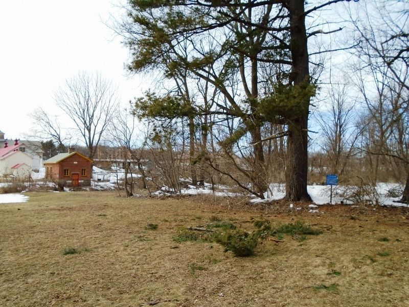
The Shakers stored milk in the creamery to keep it cool. Milk was brought from the barn in large milk cans, which were then kept cool in troughs filled by water diverted from the creek. Later the building was used as a hen house; now it is used . . . — — Map (db m115688) HM
This brick building was used by the ministry elders. Each member of the ministry had to perform daily manual labor such as shoe making or tailoring. Elder Chauncey Copeley a cabinet maker, worked in a wing added to the building in 1850. . . . — — Map (db m115660) HM
On Meeting House Road, on the right when traveling north.
This Meeting House, or Church, was built in 1848 to replace an earlier (1791) and much smaller Meeting House. It demonstrates many typical characteristics of Shaker architecture; double doors, one for men and one for women; a large meeting room . . . — — Map (db m115663) HM
On this location was a large 3 1/2 sto[r]y stone building. Here Shaker Sisters did spinning, weaving, and sewing. Journal entries indicate that Sister Polly wove 3350 Shaker bonnets in this building.
The building was the only stone building . . . — — Map (db m115656) HM
On Meeting House Road, on the left when traveling east.
Shaker Creek provided water for both the canning and laundry operations. The first laundry, done on December 12, 1859, used a steam powered washing machine. Albany County used the building for laundry until the mid 1980s. Today it is a workshop. . . . — — Map (db m115674) HM
On North Pearl Street (New York State Route 32) at State Street (New York State Route 5), on the right when traveling south on North Pearl Street.
The city of Albany is home to six National Historic Landmarks and more than 4,000 properties listed on the New York State and National Register of Historic Places.
In 2015, Albany was designated a Preserve America Community by President . . . — — Map (db m116698) HM
In the middle of State, formerly Yonkers Street, one block below, stood the First English Church, built A.D. 1715, upon ground granted by letters patent from King George the First. It bore the name of St. Peter's Church. The parish was incorporated . . . — — Map (db m76381) HM
On Maple Avenue (New York State Route 146), on the right when traveling west.
St. John’s Lutheran Church, designed by Albany architect Charles Nichols and built by contractor George Rockefeller in 1871-72 was the first church built in Knowersville. The original church building was 42 x 62 feet and, completely . . . — — Map (db m131427) HM
On Loudon Road (U.S. 9), on the left when traveling north.
Early Settlers at Boght and Crescent. Intermarried with Lansing's. Organized the Boght Reformed Church in 1784. Fonda Rd. is named for the family. — — Map (db m129626) HM
Near Mohawk Street near Ontario Street, on the right when traveling south.
Horace Brinsmade Silliman was born in 1825. He was educated in Albany Academy, graduated from Union College in 1846 (a member of Phi Beta Kappa) and later received honorary degrees from Union and Hamilton Colleges.
Silliman first became a . . . — — Map (db m41361) HM
On Boght Road (New York State Route 9R), on the right when traveling west.
The Boght
Settled On and After
1704 By The
Vischer Weaver Witbeck
Lansing Powell Runkle
Dunsbach Lieverse Staats
Roff Godfrey Van O Linde
Groesbeck Van Vranken Fero
Van De Mark Van Denburgh
Johnson Pollock Storms
Fonda and . . . — — Map (db m24731) HM
On Delaware Turnpike (New York State Route 443), on the right when traveling west.
Founded and Erected 1825. "For The Glory of God" quoted from 1824 land deed. Horse sheds built 1840. Fellowship hall added 1906. — — Map (db m97276) HM
On New Scotland Road (New York State Route 85) at Helderhill Road, on the left when traveling west on New Scotland Road.
Original part built c. 1816. revolutionary War Captain. Served 3 area churches from 1794-1825. His descendants lived in home until 1922. — — Map (db m136073) HM
On New York 145, on the right when traveling north.
Baptist Church formed as "First Church of Rensselaerville." Proposed first Am. Baptist Missionary Society and Natl. Baptist Assembly, 1801. Church built, 1846. — — Map (db m241630) HM
This bell was cast by the Meneely Bell Factory (1826-1951) for the former North Dutch Reformed Church located on the North West Corner of 1st Avenue and 15th Street. This was the third Meneely Bell which tolled for its congregation. The first bell . . . — — Map (db m185074) HM
The most obvious music associated with any church is the sweet and dignified tolling of the church bell. Pictured above is George E. Hipwod, President of the Holy Names Society who presented the bell for placement in the new church.
The bell was . . . — — Map (db m70628) HM
On Fairview Road (County Route 36) 0.1 miles south of Freedom Road (County Route 3), on the left when traveling north.
This building was originally known as the First Presbyterian Church of Centerville. Church members purchased this lot in 1858 and began construction of the church, completing it in 1859 at a cost of $3,000. — — Map (db m75936) HM
Near Jungle World Road south of Bronx River Parkway, on the right when traveling south.
Père David's deer are named for French missionary "Père" (Father) David who discovered them for the Western world in 1865 in a Beijing hunting park. Their Chinese nickname is "ssu-pu-hsiang" refering to four characteristics that are . . . — — Map (db m193271) HM
In commemoration of the solemn pontifical mass marking the bicentennial of the Archdiocese of New York offered by His Holiness Pope Benedict XVI April 20 2008 here in Yankee Stadium. Gift of Knights of Columbus. — — Map (db m192135) HM
In commemoration of the mass for world justice and peace offered by His Holiness Pope John Paul II October 2, 1979 here in Yankee Stadium. Gift of the Knights of Columbus. — — Map (db m35059) HM
In commemoration of the solemn mass for peace offered by His Holiness Pope Paul VI October 4, 1963 here in Yankee Stadium. Gift of Knights of Columbus — — Map (db m183058) HM
On Jerome Avenue north of East 164th Street, on the right when traveling north.
What was here before?
A creek, called Metipathe by the Lenape, once ran through this land into the Harlem River after following a course along what are now River and Jerome Avenues. When European settlers arrived, the creek was sold to John . . . — — Map (db m228714) HM
On Henry Hudson Parkway West, 0.1 miles south of West 249th Street, on the left when traveling north.
Designed in an English Gothic style by James Renwick, architect of St. Patrick's Cathedral, this church was built in 1863, funds having been contributed by residents of Riverdale including William E. Dodge, Jr., Joseph Delafield, Robert Colgate and . . . — — Map (db m193302) HM
On Saint Ann's Avenue at East 139th Street, on the right when traveling south on Saint Ann's Avenue.
Padre Plaza honors Father Roger Giglio (1943-1990), founder of St. Benedict the Moor Neighborhood Center. A native of Woburn, Massachusetts, Father Giglio was ordained in 1970 and served as the director of the Christian Formation Retreat Center . . . — — Map (db m209734) HM
On Hugh J. Grant Circle at Metropolitan Avenue on Hugh J. Grant Circle.
What was here before?
This site was once a tract of farmland owned by the Pugsley family in the early 19th century. The land became part of the Cobb and Larkin family farms in the late 1800s, until the City acquired it incrementally in the . . . — — Map (db m238051) HM
The original church on this site was built in 1700 to house a parish organized by an act of the Provincial Assembly in 1693. Queen Anne contributed an altar in 1708. In 1763 a charter was received from King George III. The present church, designed . . . — — Map (db m52223) HM
On Main Street (New York State Route 17C) at Oak Street, on the left when traveling east on Main Street.
Trinity Memorial Episcopal Church has been placed on the National Register of Historic Places in 1998 by the United States Department of the Interior. — — Map (db m198201) HM
On Hawleyton Road (County Route 117) at Saddlemire Road (County Route 125), on the right when traveling south on Hawleyton Road.
First called The Hemlocks.
You are here X
1. Water Powered Mill
2. Blandings Store
3. Town Hall
4. Hawleyton Creamery
5. Hawleyton ME Church and Parsonage Given by James Hawleyton
6. Lyceum Hall - Later Blacksmith Shop
7. Hawleyton . . . — — Map (db m220880) HM
On New York State Route 98 at Galen Hill Road, on the right when traveling east on State Route 98.
Salem Welsh Church built 1855 has been listed in the National Register of Historic Places by the United States Department of the Interior — — Map (db m86649) HM
On U.S. 62 at Cherry Creek Hill Road (County Route 6), on the right when traveling south on U.S. 62.
Leon United Methodist Church has been placed on the National Register of Historic Places in 2000 by the United States Department of the Interior — — Map (db m133018) HM
On Otto-East Otto Road (County Route 12) 0.2 miles east of North Otto Road (County Route 11), on the right when traveling east.
Medora Ball Historical Museum has been placed on the National Register of Historic Places by the United States Department of the Interior The First Congregational Church of Otto 1861 — — Map (db m133002) HM
On East Genesee Street (U.S. 20) at Gaylord Street, on the right when traveling west on East Genesee Street.
St. Alphonsus Church was founded by German-speaking Catholics in 1853. The congregation worshipped in a church on Water Street until this ediface was erected in 1930. — — Map (db m88366) HM
On North State Road (New York State Route 34 at milepost 30.5), 0.2 miles south of Downs Road, on the left when traveling south.
William McCreedy and family, burial site. Soldier in Revolution. Born 1755 - Died 1824. Early Methodist meeting held in nearby family home. — — Map (db m88480) HM
On Main Street (New York State Route 370) 0.1 miles east of Bonta Bridge Road (County Route 18B), on the right when traveling east.
For many years a Magistrate of this Town & County. The founder of this Village and this Church which he served with christian fidelity as ruling Elder from the time of its organization until his death. Born at Glastonbury Conn. Sept. 26, 1782, . . . — — Map (db m83813) HM
On McDonald Road (County Route 114A) at Mentz Church Road (County Route 115), on the left when traveling east on McDonald Road.
First Methodist Episcopal Church Inc. 1825 with John Gilmore, Wm. Bell & James Weston, Trustees. Adjoining cemetery in use by 1813. — — Map (db m83525) HM
Near Utica Street (New York State Route 31) 0.3 miles east of Main Street (New York State Route 38).
Lock 52 in Port Byron was a busy place prior to 1917. In the vicinity of the lock, you would have seen a bustling waterfront, with dozens of boats locking up or down the canal. At Tanner's Dry Dock, just up the canal from the lock, canal boats were . . . — — Map (db m83641) HM
Near Utica Street (New York State Route 31) 0.2 miles east of Main Street (New York State Route 38).
1. Park Hotel: Dates from the bustling railroad days in the mid-eighteen hundreds when it was known as "National Hotel". The Park Hotel was built by Samuel Lamkin in 1835. Its reputation and ownership has changed many times. 2. Masonic Block: . . . — — Map (db m83600) HM
On New York State Route 104A at New Street, on the left when traveling east on State Route 104A.
Site of first Baptist church of Sterling erected in 1841, federated with United Presbyterian in 1931 Churches consolidated in 1962 Sold and dismantled in 1970 — — Map (db m79782) HM
On New York State Route 90, 0.1 miles south of Great Gully Road, on the left when traveling south.
This valley was the site
of the principal
Cayuga Indian village
To the brave French Jesuit
missionaries whose heroism
was almost without parallel
Joseph Chaumonot
and Rene Menard
who as guests as of
Chief Saonchiogwa
built here in 1656 . . . — — Map (db m145842) HM
On Liberty Street, 0.1 miles east of S. Seneca Street, on the left when traveling east.
First Baptist Church of Weedsport has been placed on the National Register of Historic Places in 2003 by the United States Department of the Interior — — Map (db m157012) HM
On Dennison Road (County Route 89) at King Road, on the right when traveling south on Dennison Road.
Hanover resident, 1816-1836, at Dennison's Corners and Keach's Corners. Clerk of Dennison's Corners School #10 and of Forestville Baptist Church. Studied law, taught, and married in Silver Creek. Attended Fredonia Academy. Ellington Postmaster, . . . — — Map (db m105659) HM
On East 3rd Street, 0.1 miles east of Prendergast Avenue, on the right when traveling west.
First Congregational Church First Congregational Church. Organized June 16, 1816. Jamestown's first religious society. Met at Main and Fifth Streets where a church built in 1829 served until this Gothic ediface was erected in 1869. This is the . . . — — Map (db m94857) HM
On North Main Street at West 5th Street (New York State Route 394), on the left when traveling north on North Main Street.
Here The First School House the "Prendergast Academy" was built in 1816. Church services were held here until The First Church was erected in 1829 on the same site by "The First Congregational Church and Society" organized in 1816. . . . — — Map (db m94872) HM
On Glasgow Road (County Route 48) at Dale Drive (County Route 48), on the left when traveling east on Glasgow Road.
Lily Dale Timeline 1955 Fox cottage burns. 1924 Marion H. Sidmore Library building constructed. 1915 Fox cottage moved to Lily Dale. 1900 Great Lily Dale fire burns many cottages. 1893 Lily Dale contains 215 cottages. 1888 Assembly Hall . . . — — Map (db m94898) HM
Near Central Avenue (New York State Route 5) at Parkway Avenue.
Built in 1846 by Major Clark C. Swift, this mansion was constructed in the Federal Style with bricks handmade on the site.
It was acquired for Our Lady of Mt. Carmel Parish in 1914, through the efforts of Msgr. E.J. O'Connor. The mansion was used . . . — — Map (db m64722) HM
On South Portage Street (Route 394) north of McClurg Street, on the right when traveling north.
Westfield, New York
Founded 1808
First Church in Chautauqua County
Called Chautauqua Church
Organized by Rev. John Lindsey
Met at cross roads
Part of Presbytery of Erie, Pennsylvania
Transferred to Presbytery of . . . — — Map (db m132189) HM
Founded in 1840
stood 300 feet west of here
played a role in the
underground railroad &
was a center of Elmira's
African-American Community — — Map (db m66950) HM
On East Water Street (New York State Route 352) at Harriet St., on the right when traveling west on East Water Street.
The first Methodist sermon in this area was given near this site at Lough’s Tavern, Newton Village, by Rev. William Colbert, Dec. 16 1792.
Text Mathew 5:6 "Blessed are They That Hunger and Thirst After Righteousness." This Circuit rider dressed in . . . — — Map (db m41576) HM
On Wilawana Road (New York State Route 427) 1.3 miles east of Main Street, on the left when traveling east.
• The site of • First Church of any denomination —in— Chemung Valley was one-fourth mile north ———— Organized September 2, 1789 by Roswell Goff, First Pastor —and— William Buck • John Hillman Peter Roberts • John Roberts Jesse . . . — — Map (db m198216) HM
On East Main Street, on the right when traveling north.
Established in 1818 as the Universalist Church burying ground and now called East Side Cemetery. Many early settlers buried here. — — Map (db m230671) HM
On Church Street at East Main Street, on the right when traveling north on Church Street.
Society founded March 31, 1793 through
the efforts of the
Rev. William A. Stone
of the Vermont Domestic Missionary
Society.
The first church was erected in 1793,
and was destroyed by fire in 1814.
The present building was erected in . . . — — Map (db m146817) HM
1155 entries matched your criteria. The first 100 are listed above. Next 100 ⊳