Since its construction in 1892 as a meeting hall, this building has been in continuous community service. In addition to its use for community meetings, the building also was used for an elementary school, church services, a nursery school, a . . . — — Map (db m55375) HM
African American residents struggled through segregation and also faced challenges during the integration of Arlington Public Schools. Therefore, leaders sought solutions to accommodate the increasing population as schools and housing were . . . — — Map (db m214459) HM
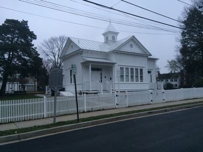
The Little Zion Congregation was organized in 1866 by residents of Freedman's Village. The congregation purchased this site in 1874. In 1867, T.H. Lomax was elected Bishop of the AME Zion Church and assigned to the Washington, D.C. area. The Little . . . — — Map (db m130988) HM
Macedonia Baptist Church was the first African-American church established by residents in the Nauck community. Founded in 1911, the church traces its origins to prayer meetings held in 1908 at the home of Bonder and Amanda Johnson at 22nd Street . . . — — Map (db m69190) HM
As soon as the smoking guns of the Civil War were finally silenced, a group of former slaves banded themselves together in what was then known as Freedmen’s Village, a government reservation in the area of Arlington National Cemetery, and founded a . . . — — Map (db m69189) HM
Churches fulfilled a critical role in the growth and development of Green Valley. They served as social and spiritual anchors while providing sanctuary for generations of residents.
[Captions:]
The Methodists were the first . . . — — Map (db m214455) HM
Walker Chapel, a small frame country church of the Mount Olivet Circuit, was dedicated at this location on July 18, 1876. It was named in honor of the Walker family who donated the Walker Grave Yard as the site for the church. A new frame church was . . . — — Map (db m2316) HM
Founded in 1903, the congregation of St. John's Baptist Church proudly recalls African-American heritage in Arlington County. Some of the early members were emancipated slaves or relatives of emancipated slaves who either lived in slave quarters at . . . — — Map (db m134970) HM
Dedicated on May 5, 1960, the 15th anniversary of the liberation of the Netherlands, the Netherlands Carillon was presented "From The People Of The Netherlands To The People Of The United States" in gratitude for assistance given during and after . . . — — Map (db m129467) HM
Margaret Elizabeth Pfohl Campbell was born to a Moravian family in North Carolina, where her upbringing and education led her to devote her life to seeking educational opportunities for others. She served as dean of Staunton's Mary Baldwin College . . . — — Map (db m55736) HM
The glebe was a 500-acre farm provided for the rector of Fairfax Parish, which included both Christ Church, Alexandria, and the Falls Church. The Glebe House, built in 1775, stood here. It burned in 1808 and was rebuilt in 1820, as a hunting lodge; . . . — — Map (db m208536) HM
This is Arlington’s oldest church site in continuous use. Land for a Methodist Protestant Meeting House was conveyed in 1855 by William and Ann Marcey and John B. and Cornetia Brown, for whom Brown’s Bend Road (now 16th Street, North) was named. The . . . — — Map (db m56225) HM
This was first the Southern Branch of the “Triple Forks of Shenandoah” Congregation, which called John Craig as pastor in 1741. A church was completed here about 1748; two other buildings have succeeded it. Beginning with 1777, James Waddel, the . . . — — Map (db m122178) HM
This, the oldest Presbyterian house of worship in Virginia, is an eloquent memorial to the liberty-loving, god-fearing Scotch-Irish folk who first settled this part of the valley.
Through their arduous labors the building was completed in 1747 . . . — — Map (db m89111) HM
The Augusta Stone Church, Virginia's oldest Presbyterian church in continuous use west of the Blue Ridge Mountains, opened on 22 Jan. 1749. It replaced a log meetinghouse built shortly after the congregation's founding in 1740. At the outbreak of . . . — — Map (db m155473) HM
John Craig, born in County Antrim, Ireland, and educated in Edinburgh, Scotland, immigrated to America in 1734. Ordained pastor in 1740 of the two churches known as Augusta Stone and Tinkling Spring, Craig was Virginia's first settled Presbyterian . . . — — Map (db m155472) HM
Shenandoah Valley circuit-riding preacher Paul
Henkel formed Mount Tabor Lutheran Church
about 1785, several miles to the east. It shared a
log building with St. John’s, a Lutheran and
Reformed union congregation. Under the direction
of David . . . — — Map (db m50578) HM
Salem Evangelical Lutheran Church traces its existence to 1789 when Shenandoah Valley circuit preacher Paul Henkel held services for the German community in a schoolhouse nearby at Seawright Springs. By 1805, the congregation had built a frame . . . — — Map (db m30445) HM
The Rev. John Blair, a minister influenced by the Great Awakening, organized New Providence Presbyterian Church about 1746. The congregation moved to a site seven miles west of here about 1760, and the present Greek Revival-style sanctuary was . . . — — Map (db m172318) HM
Two miles west. The first church was built by Colonel Robert Doak in 1779. Captain James Tate, an elder, led in the battles of Cowpens and Guilford Courthouse (1781) a company drawn mainly from this church. In the churchyard 23 Revolutionary . . . — — Map (db m32104) HM
Two and a half miles northwest. As early as 1748 a log meeting house stood there. In 1793 a stone church (still standing) was built. In 1859 it was succeeded by a brick church, which gave way to the present building in 1918. In the graveyard rest . . . — — Map (db m23759) HM
The vestry of Augusta Parish purchased 200 acres here in 1749 to serve as a glebe, farmland set aside to support the minister. Just to the southwest, on a portion of this property, the parish established the first public cemetery in the vicinity. . . . — — Map (db m159738) HM
This church, seven and a half miles west, was organized by John Blair in 1746. Five successive church buildings have been erected. The first pastor was John Brown. Samuel Brown, second pastor, had as wife Mary Moore, captured in youth by Indians . . . — — Map (db m122187) HM
Scotch-Irish Presbyterians, seeking freedom of worship and led by the Rev. Alexander Craighead, built a log meetinghouse a mile and a half down the Cowpasture River about 1749. Indians burned it during the French and Indian War. Moving to this site . . . — — Map (db m122193) HM
Born in Waynesboro to former slaves, William H. Sheppard became a Presbyterian missionary to the Belgian colony of Congo Free State in 1890. He and others opposed King Leopold II of Belgium, who encouraged such atrocities as the amputation of . . . — — Map (db m5607) HM
The four chaplains giving the National D-Day Memorial field chapel its name were among 4 soldiers, merchant seamen, naval armed guard, coast guardsmen, and civilian workers embarked for Greenland aboard USAT Dorchester . At 0100 hours on 3 . . . — — Map (db m241069) HM WM
A Quaker Meeting was established on Goose Creek in 1757, and a meeting house built. Fear of Indians caused most of the Quakers to move elsewhere though some of them returned. Unsuccessful attempts were made to re-establish the Goose Creek Meeting. . . . — — Map (db m65610) HM
Half a mile north is St. Stephen's Church, built about 1825 under Rev. Nicholas Cobb, later Bishop of Alabama. In the old cemetery here many members of early families of the community are buried. — — Map (db m42894) HM
On April 11, 1790, a congregation of 32 organized here as the “Baptist Church of Christ on Stanton at the mouth of Black Water.” William Johnson, John Anthony and Thomas Douglass were the ministers present and Johnson was chosen pastor. . . . — — Map (db m153024) HM
William Elbert Munsey was born a few miles
east in the mountains of Giles (present-day Bland)
County on 13 July 1833. Despite little formal
schooling, Munsey possessed an insatiable
appetite for knowledge. He entered the ministry
of the . . . — — Map (db m44810) HM
Buchanan Baptist Church
Dedicated on October 8, 1876
Has been placed on the
National Register
Of Historic Places
By the United States
Department Of The Interior — — Map (db m140259) HM
“The new church at Buchanan deserves a word of special notice. It is chiefly the result of female enterprise. A lady well known in Virginia who occasionally visited the town, fleeing from the sultry heat of summer, determined to effect by . . . — — Map (db m140359) HM
Daleville College began as a private school that Church of the Brethren educator Isaac N. H. Beahm conducted for the children of Benjamin F. Nininger and George Layman in 1890. The construction of school buildings began the following year. In 1892, . . . — — Map (db m63212) HM
The (Roanoke) Valley Baptist Association was organized on 7 August 1841 at nearby Zion Hill Baptist Church. Seventeen congregations constituted the original fellowship of churches; during the next century and a half membership grew to more than . . . — — Map (db m84226) HM
In 1865, at the dawn of their freedom from slavery, 42 former members of the white-led Goodson (now First) Baptist Church organized the Anglo African Baptist Church. The congregation met in a series of buildings until, under the leadership of the . . . — — Map (db m210167) HM
Though many freed African Americans continued after the Civil War to work the same farms on which they had been slaves, many also left their homes in search of better opportunities elsewhere. Often the sick, elderly, and very young were left . . . — — Map (db m180524) HM
Erected in loving memory of the Rev. Jesse C. Byrd D.D. as builder of present structure and pastor of Oak Grove 1943 - 1964 by the members. — — Map (db m180531) HM
Saint Paul’s College began as a small parochial school founded by a newly ordained Episcopal deacon, the Rev. James Solomon Russell. Born into slavery, Russell attended seminary school in Petersburg. Within a year of graduation he had managed . . . — — Map (db m30870) HM
Saint Paul's College was established in 1883 by the Venerable James Solomon Russell (1857-1935) as an Episcopal mission school to serve the black community of Southside Virginia. Born into slavery in Mecklenburg County, Russell was educated at . . . — — Map (db m20187) HM
The Brunswick Circuit, established in 1773 by Robert Williams, is likely the oldest Methodist circuit in America. It extended from Petersburg south into North Carolina, and became known as “the cradle of Methodism in the South.” By 1776, the . . . — — Map (db m60671) HM
Near here stood Mason's Chapel, one of the earliest Methodist churches in southern Virginia. The first Virginia conference, May, 1785, was held here or nearby; Bishop Asbury presided. The conference of 1801 was held here. The present Olive Branch . . . — — Map (db m60673) HM
A few hundred yards east is the site of Ebenezer Academy, founded in 1793 by Bishop Asbury, the first Methodist school established in Virginia. It passed out of the hands of the church but remained a noted school for many years. — — Map (db m62405) HM
African Americans had established Chief Cornerstone Baptist Church by 1876, during a period when many Black southerners worked to build independent community institutions in the wake of Emancipation. John and Harriet Gregory, who had formerly been . . . — — Map (db m239969) HM
Rev. Stephen J. Ellis (1865-1937)
This park is the site of the first high school for Black Students in Buckingham County, founded by Rev. Ellis.
Buckingham Training School Campus, 1924-1954. National Register of Historic Places, . . . — — Map (db m181213) HM
Built in early eighteenth century by order King of England as an Episcopal Church. Reorganized as Baptist Church in 1771 with Rene Chastain, Pastor — — Map (db m28527) HM
The original or southwest wing was erected about 1758 as a church for the newly-formed Tillotson Parish. It was abandoned following the Disestablishment of the Anglican Church in Virginia in 1784, and thereafter was acquired by the Buckingham . . . — — Map (db m21131) HM
Four and a half miles north stands Hat Creek Presbyterian Church, founded by John Irving and associates (first settlers) about 1742. William Irving, son of John, and the noted blind preacher, James Waddel, were among its pastors. The first log . . . — — Map (db m122066) HM
(front of marker) The first African-American slaves were brought to Caroline County around 1700. Few records were kept of their existence, except for their status and value as property and the occasional brush with the law. Many slaves of . . . — — Map (db m34350) HM
Pioneers in asserting the right to religious freedom, the Caroline Friends (Quakers) held their first meeting nearby on 12 March 1739 together with their partner, Cedar Creek Friends Meeting of Hanover County. At a meeting on 9 May 1767, members . . . — — Map (db m9213) HM
St. Peter's Church
Consecrated by
Bishop Moore
May-15th 1836
This church replaced
earlier buildings
destroyed by fire.
The Parish St. Mary's,
Dates to 1677
to it came from
England an early pipe . . . — — Map (db m133747) HM
On this lot in 1820 the first church to be constructed in the Town of Port Royal was built. The brick building had 12 windows and was inter-denominational. By 1844 it was known as the Methodist Church, even though ministers of other denominations . . . — — Map (db m57503) HM
On this site stood colonial Mount Church, built about 1750. In 1808 the parish glebe was sold and the proceeds were used to establish a school; the church building was turned into Rappahannock Academy, one of the most noted schools in Virginia. — — Map (db m22578) HM
The scattered corps of the Union army reunited here at Carmel Church (known during the war as Mount Carmel Church) on May 23 before attacking Confederate Gen. Robert E. Lee across the North Anna River, approximately three miles ahead. Gen. Winfield . . . — — Map (db m3693) HM
This tablet is placed here in the year 1922 by the churches of
The Hermon Baptist Association
to commemorate the heroism of
Bartholomew Chewning •
John Young •
Lewis Craig •
Edward Herndon •
John Burrus •
James Goodrich . . . — — Map (db m180256) HM
"At the church…the 9th Corps was marching past, and Burnside was sitting, like a comfortable abbot, in one of the pews, surrounded by his buckish staff whose appearance is the reverse of clerical.” – Theodore Lyman, aide-de-camp . . . — — Map (db m116535) HM
is designated a Virginia Historic Landmark by the Virginia Department of Historic Resources and placed on the National Register of Historic Places by the U.S. Department of the Interior 2007 — — Map (db m181418) HM
This intersection of the Old Main Road, or Ridgepath, and the road from Soanes Bridge to Kennons, derives its name from an eighteenth-century tavern owned by the Blanks family. Blanks Tavern was one of a few licensed ordinaries in colonial Charles . . . — — Map (db m17575) HM
The Herring Creek area was settled in 1619, as a portion of Westover, and a portion of Berkeley Hundred. The point where the James River Road, present-day Route 5, crossed Herring Creek was known as "The Wade." Landmarks have included Harrison's . . . — — Map (db m9288) HM
A mile and a half northwest, Lott Cary was born in slavery about 1780. In 1804 his owner, John Bowry, a Methodist minister, hired him out to a Richmond tobacco firm. Cary joined the First Baptist Church in 1807. He purchased his freedom and became a . . . — — Map (db m26338) HM
These communities were established on opposite banks of Morris Creek , earlier known as Tanks Pasbye hayes the Indian name, Moyses Creek after Theodore Moyses who patented land there, and as Moses Creek. Before 1720 this area was part of James City . . . — — Map (db m26333) HM
This community was the site of a Quaker settlement in the eighteenth century and the Weyanoke Quaker Meeting House and graveyard. The meetinghouse was the Upper Quarter gathering place for the Yearly Meeting of Virginia Quaker. The area has since . . . — — Map (db m26328) HM
This area was one of the centers of Charles City's free black community before the Civil War and was named for Ruth Brown with the establishment of the post office in 1880. Abraham Brown, a major landowner of the area, founded Elam Church in 1810, . . . — — Map (db m26334) HM
This church, four miles north, was used as a field hospital, June, 1864, following the action an Nance's Shop, where the Union cavalryman Gregg, guarding a wagon train, was attacked by Wade Hampton. Gregg was driven from the field but saved the . . . — — Map (db m9600) HM
This area was settled before 1622 by George Shinehow. Tobacco warehouses and docks were located at Swineyards and Willcox Wharf. A post office was established at Swineyards in 1848 and later located at Willcox Wharf. Landmarks have included Bethany . . . — — Map (db m9405) HM
Early colonists in Jamestown migrated westward, bringing Anglican worship there as early as 1613. Westover Parish was recognized in 1625 by the House of Burgesses. A church built in 1630 at Westover Plantation was moved to its present site in 1731. . . . — — Map (db m221020) HM
A short distance south is Westover Church. It was first built on the James River near Westover House early in the Seventeeth century. About 1730 the site was changed and the present building erected. Defaced in the campaign of 1862, the church was . . . — — Map (db m9401) HM
Wayside was settled after 1613 as part of West and Sherley Hundred. Landmarks have included St. John's Church, established in 1897 by the Rev. John Jones, a post office at Shirley and the Shirley Mill. In 1921 the Wayside Community Club assisted in . . . — — Map (db m9252) HM
Just to the north stands Briery Church, organized in 1755 following the missionary work of Presbyterian minister Samuel Davies. The first church was built about 1760 and was replaced in 1824. The present Gothic Revival church was built about 1855 . . . — — Map (db m40794) HM
Six miles south is Cub Creek Presbyterian Church, the oldest church in this section. The neighborhood was known as the Caldwell Settlement for John Caldwell, grandfather of John C. Calhoun of South Carolina. About 1738 he brought here a colony of . . . — — Map (db m66062) HM
Cub Creek Presbyterian Church, the oldest church in this area, stood four miles southwest of here. The neighborhood was known as the Caldwell Settlement for John Caldwell, great grandfather of U.S. senator and vice president John C. Calhoun, of . . . — — Map (db m182500) HM
A chapel was built here in 1765-1769 by order of the vestry of Cornwall Parrish. Following the disestablishment and a brief period of irregular use, the property passed to the Republican Methodists, a denomination then active in the South. It was . . . — — Map (db m66061) HM
After the Civil War, in the Red Oak area of Charlotte County, many freed slaves were welcomed to worship at Antioch Baptist Church, a traditionally white church. The Antioch congregation helped raise money to build Salem Baptist Church in . . . — — Map (db m30999) HM
After the Civil War, in the Red Oak area of Charlotte County, many freed slaves were welcomed to worship at Antioch Baptist Church, a traditionally white church. The Antioch congregation helped raise money to build Salem Baptist Church in . . . — — Map (db m182464) HM
The Charlottesville African Church
congregation was organized in 1864. Four years later it bought the Delevan building, built in 1828 by Gen. John H. Cocke, and at one time used as a temperance hotel for University of Virginia students. It became . . . — — Map (db m8824) HM
This is the Deep Creek Lock of the Dismal Swamp Canal, the northern end of the waterway linking the North Carolina sounds with Hampton Roads and the Chesapeake Bay. Deep Creek village evolved on the canal to serve workers, boatmen, and the . . . — — Map (db m165286) HM
Site of
Southern Branch Chapel
A Chapel of ease of the Anglican Church
for the
Elizabeth River Parish 1701 - 1761
St. Brides Parish 1761 - 1845
Encampment area for American Patriots
Battle of Great Bridge
December 1775 . . . — — Map (db m48944) HM
A direct outgrowth of the New Mill Creek Society organized in 1772 by the Rev. Joseph Pilmoor, the first official Methodist missionary to America. Methodist meetings were held as early as 1770 in the Cutherell home, a regular preaching place for . . . — — Map (db m48923) HM
At this point stood St. Bride's Church. The parish church of St. Bride's Parish which was established in 1761. The church, sometimes known as Northwest Church, was built in 1762 and survived until 1853. — — Map (db m46530) HM
Thirteen African American veterans of the Civil War are interred nearby at the Cuffeytown Historic Cemetery. They served in the 5th, 10th, and 36th United States Colored Troops infantry regiments organized in 1863 and 1864, after the Emancipation . . . — — Map (db m48917) HM
A Bomb Proof Church ?
The purpose of this structure remains a mystery. It may be the remains of one of the "Bomb Proof” churches that were built in this part of the Howlett Line. One such church was built by men of the 17th Virginia, . . . — — Map (db m101030) HM
Enon Baptist Church was organized on 8 October 1849. The church was built here on a one-acre tract given by the founder, John Alexander Strachan. In May 1864, during the Civil War, Union army troops under Maj. Gen. Benjamin F. Butler dismantled Enon . . . — — Map (db m24990) HM
In 1867, the African American members of
nearby Salem Baptist Church separated and
founded Salem African Baptist Church. The
new congregation held worship services under
a brush arbor before constructing a building
here on a one-acre tract . . . — — Map (db m107773) HM
Near this spot was built
Anno Domini 1611
The Church of Henricopolis
Under the auspices of
Sir Thomas Dale
High Marshall of Virginia
The Reverend Alexander Whitaker, M.A,
Minister
This cross is erected to
Commemorate the . . . — — Map (db m16147) HM
On this spot were imprisoned 1770-1774
John Tanner
William Weber
Augustine Eastin
David Tinsley
Joseph Anthony
Jeremiah Walker
John Weatherford
Apostles of
Religious Liberty
“Whether it be right . . . — — Map (db m19527) HM
Late in the 18th century, the Methodist Episcopal Church confronted the possibility of schism. James O'Kelly, a Methodist minister, began challenging Bishop Francis Asbury regarding his appointive powers, his management of church affairs, and other . . . — — Map (db m26013) HM
In 1799 the local Baptist Society acquired this land and soon built a meetinghouse. The Bethel congregation worshiped in the meetinghouse and was constituted as a church in 1817. About 1820 the members built a brick church here--the first in . . . — — Map (db m19051) HM
Eleazar Clay (1744-1836) led the establishment of the first Baptist church in Chesterfield County, known as Chesterfield (Baptist) Church, Rehoboth Meeting House, or Clay's Church, in 1773. He also supported the Baptist preachers imprisoned for . . . — — Map (db m35993) HM
In 1700-1701, Huguenots (French Protestant refugees) settled in this region on land provided to them by the Virginia colony. The Huguenot settlement, known as "Manakin Town" centered at the former site of a Monacan Indian town, located south of the . . . — — Map (db m31544) HM
First African Baptist Church of Coalfield, which stood about a mile southeast of here, opened a school for African Americans in 1866. After a fire in 1877, the congregation moved here and renamed itself First Baptist Church in Midlothian. Church . . . — — Map (db m180215) HM
The Mid-Lothian African Church
Near the Grove Shaft, 54 free blacks, slaves and six white males at the Mid-Lothian Coal Mining Company started the Mid-Lothian African Church on February 8, 1846. Assisted by the company the 60 member . . . — — Map (db m31571) HM
Coal Mining Chronology in Chesterfield
1835 Mid-Lothian Coal Mining Company is chartered.
1836 The Company organizes with 3,000 shares valued at $100 each with 1,000 shares being sold to raise $100,000 capital. The Wooldridge family . . . — — Map (db m31572) HM
Winfree Memorial Baptist Church, constituted in 1852 as Jerusalem Baptist Church, originally stood to the west on Buckingham Pike. In September 1881, to better serve the coal mining community, the frame structure was rolled here on logs. On 3 Feb. . . . — — Map (db m35994) HM
Pastor William Hickman and about 30 people founded Skinquarter Baptist Church in 1778. The first meetinghouse was located east of the church's cemetery. Hickman moved to Kentucky in 1784 and was an early Baptist leader there. Due to anti-missionary . . . — — Map (db m28921) HM
Formerly Spring Creek Church. Organized, July 25, 1790. Benjamin Watkins, founder and first pastor, 1790-1831. Located four miles northwest, 1790-1855. Then four miles southwest, 1855-1897. Moved to this location, 1897.
Home church of Nannie . . . — — Map (db m31545) HM
Bethlehem Baptist Church, first known as Cox's Meeting House and then Spring Creek Church, was formally organized several miles northwest of here in 1790. Founding pastor Benjamin Watkins served for 41 years. African Americans constituted a . . . — — Map (db m170046) HM
The little white chapel that stood here was built by soldiers of the garrison and held 150 people. Different ministers came from Richmond each week to preach. A small burial ground was located just 50 yards beyond the chapel—a reminder that . . . — — Map (db m37025) HM
1080 entries matched your criteria. Entries 101 through 200 are listed above. ⊲ Previous 100 — Next 100 ⊳