In the 17th century, this area was part of the formal gardens of Belfast Castle but today it is the thriving retail centre of the city. The scene is dominated by Belfast City Hall (1906), centred on Donegall Square and near this point is the . . . — — Map (db m134418) HM
You are at the Lagan Lookout and the Lagan Weir. There are fascinating places to visit in all directions from here. Head past Bigfish towards Corporation Square in the heart of Belfast's Sailortown district. There are two particularly noteworthy . . . — — Map (db m135252) HM
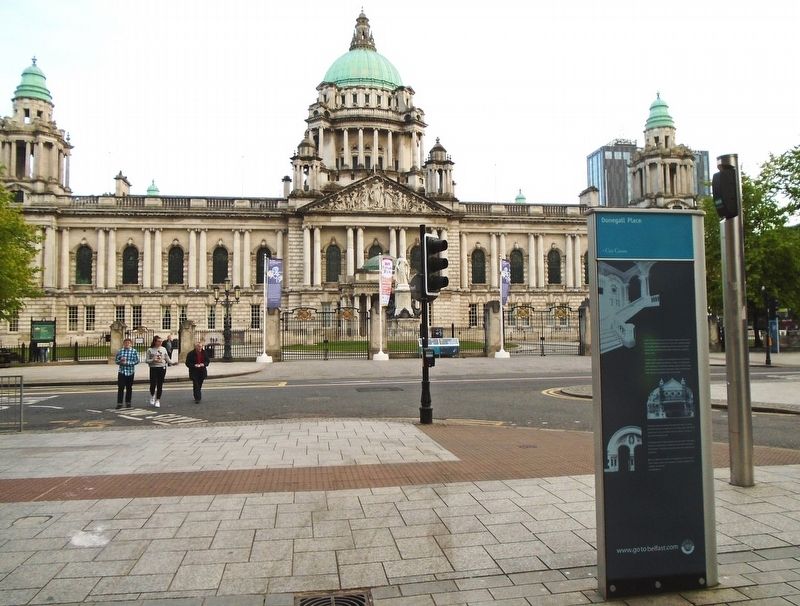
Donegall Square is the heart of modern Belfast, centred on a grassy square occupied by the City Hall and surrounded by buildings in a wide variety of styles and from different periods. The buildings provide a microcosm of the city’s development, . . . — — Map (db m133769) HM
During the late 18th and early 19th centuries, the balance of commercial power in Belfast shifted southward towards the White Linen Hall, where the City Hall, 1906, now stands. Donegall Square gradually became the heart of Belfast and Donegall . . . — — Map (db m134242) HM
Donegall Square West is dominated by the magnificent Baroque-style Scottish Provident Institution (1902) that looks out over the City Hall (1906). Take a stroll around Donegall Square and discover architectural treasures such as the Linen Hall . . . — — Map (db m133768) HM
When the Grand Opera House opened its doors on 23 December 1895, it was an instant success. Crowds flocked to see a great variety of entertainment, including opera, drama, pantomime, circus, and the latest London comedy or musical.
Since then it . . . — — Map (db m134036) HM
Two of Belfast's best loved buildings are on Great Victoria Street - the Grand Opera House (1895) and the Crown Bar (1885). Nearby, at the junction with Fisherwick Place, stands the Scottish Baronial style Presbyterian Assembly Building (1905). . . . — — Map (db m135126) HM
High Street and its environs contain a rich architectural heritage. Budding sleuths will appreciate the St. George's Building (1881), one-time home of the Ulster Overcoat Company, makers of Sherlock Holmes' famous overcoat. By way of comparison, . . . — — Map (db m135142) HM
In the 19th century Howard Street was the site of a House Of Correction which bore the inscription “Within amend, without beware” over its front door. Today the street is dominated by the gothic architecture and corner tower of the . . . — — Map (db m133823) HM
[Front]
The Olympic Slipway is where RMS Olympic was built beside her sister ship, Titanic. Although quiet and peaceful today, in 1910 this entire area was a hive of human industry, reverberating to the deafening din from steel plates being . . . — — Map (db m134902) HM
Built on Queen's Island as a tender ship for the White Star Line, SS Nomadic is most famous for the part she played in the Titanic story.
Based in Cherbourg, France, Nomadic transferred passengers from the quayside to enormous passenger liners . . . — — Map (db m135268) HM
'Our harbour now stands among the finest in the United Kingdom.'
Belfast News Letter, 2 October 1867
Hamilton Dock was filled at high tide and emptied at low tide.
[Photo caption reads]
Above This cross-section . . . — — Map (db m135269) HM
This plaque was unveiled
on 31st March 2009
by
John M Andrews,
great nephew of
Thomas Andrews, Chief Naval
Architect, Harland & Wolff
to commemorate the
centenary of
the keel laying of
RMS Titanic
Built on this slipway . . . — — Map (db m134932) HM
'Belfaste is a place meet for a corporate town, armed with all commodities, as a principal haven, wood and good ground, standing also upon a border, and a place of great importance for service ...'
Extract from a letter to the Privy . . . — — Map (db m134933) HM
1922 The Shipyards Expand Eastwards
The First World War had been a period of frantic activity in the shipyards of Belfast, with orders for both new warships and running repairs to the fleet. In 1917, both Harland & Wolff and Workman Clark & . . . — — Map (db m135114) HM
The site of St. George's Church marks the very beginning of Belfast. It is the place where settlement began and which gave the city its name. There are records of a chapel at Beal Feirste (Irish for 'the sandy ford at the mouth of the Farset') . . . — — Map (db m135145) HM
Welcome to the Quays at the mouth of the River Lagan. Set around the Lagan Weir the Quays incorporate Queen's Quay, Hanover Quay, Gregg's Quay and Donegall Quay, all closely linked with the origins of Belfast. The city derives its name from the . . . — — Map (db m135226) HM
KEY
(1) (2) The illuminated blue lines demonstrate the actual size and location of the Titanic (1) and Olympic (2) ships constructed on these two Slipways.
(3) The turfed and decked areas denote the proportions of people that survived . . . — — Map (db m135002) HM
[Front]
On 31 May 1911, SS 401, Titanic, slid down Slipway No. 3 at the Queen's Yard of Harland and Wolff and settled on the waters of the Victoria Channel in Belfast Lough. In her brief life she would be the largest, most luxurious vessel ever . . . — — Map (db m135088) HM
For almost 150 years, the Ulster Hall has brought spectacle and delight to the people of Belfast. It was built at a time when the city was attracting major artists and needed a bigger concert hall. The Ulster Hall Company was formed in 1859 to . . . — — Map (db m134240) HM
Belfast has been shaped by time and circumstance. Its buildings tell the story of change and development, of commerce and industry, entertainment and religion.
Belfast city centre is the vibrant heart of a thriving metropolis, which has shifted . . . — — Map (db m133803) HM
Demi-culverin with
Rose and Crown (C12)
Bore 4.5", Length 120"
Weight 3417lb
Cast in 1590 by Thomas Johnston
Founder of iron ordnance to
Queen Elizabeth I — — Map (db m71125) HM
Locking the gates
In 1688 James II proposed to replace the Protestant garrison in the city with Catholic troops. Rumours were rife that the citizens were to be massacred. Meeting in the Diamond, the city leaders could not make up their . . . — — Map (db m71097) HM
This gate was built in 1865 on the site of one of the four original entrances to the city. Like Bishop's Gate it had a drawbridge, which could be pulled up in times of troubles, to allow people to cross the dry moat. This was the gate that the . . . — — Map (db m71104) HM
On 5 January 1969, after a night of rioting and sustained police attacks on the Bogside, the words "You Are Now Entering Free Derry" were painted on the gable wall of 33 Lecky Road. This simple graffiti became the defining symbol of the civil . . . — — Map (db m71204) HM
The roaring cannon
The city claims Europe's largest collection of cannon whose precise origins can be traced. These are the earliest surviving cannon. Some were shipped over for Sir Henry Docwra's campaign of 1600-3: others were sent to . . . — — Map (db m71131) HM
In 1787 the walls were breached for the first time to improve access to the city centre. It is said that the gate was built to cope with crowds flocking to the New Theatre in Artillery Street but was closed in 1799 due to complaints from the . . . — — Map (db m71085) HM
You are standing on the city walls. Newmarket Street slopes up and over the wall. The street was created in the mid 19th century on the site of the Smithfield Meat Market to allow carts to the new covered market. — — Map (db m71100) HM
'A city fit for war and merchandise'
In 1600 Elizabeth I of England instructed Sir Henry Docwra to establish and fortify a new settlement on the Foyle. An explosion in the cathedral in 1567 had largely destroyed the town. Docwra and his . . . — — Map (db m71123) HM
The Mother Church
The first settlers worshipped in the ruins of the former Augustinian abbey. In 1613 the London merchant companies sent over a silver-gilt chalice as a promise of their commitment to build a cathedral to grace their new . . . — — Map (db m71072) HM
If 'stones could speak', what a story they would have to tell. Their voices still echo on the walls and in the city streets.
According to tradition St. Colm Cille chose the oak grove on top of the hill for his monastery in 546 AD. His . . . — — Map (db m71121) HM
Feabhail
The river Foyle lapped against the Water Bastion until the late 18th century. The name Foyle probably arose because English-speaking settlers had difficulty saying the Irish 'Feabhail', used traditionally to describe the stretch . . . — — Map (db m71122) HM
To Our
Honoured Dead
and
Those Who Served
1914 - 1918
1939 - 1945
Names of the Fallen
[Panels not transcribed]
Sculptures by Vernon March, 1926 — — Map (db m71133) WM
Enamel colours have always been used to decorate pottery wares. Today they come processed but in early years of the Belleek Pottery they, along with most raw materials, were processed at the Pottery.
This particular grindstone was used to . . . — — Map (db m72561) HM
Beal Leice, meaning 'the mouth of the flagstone', lies in the most westerly point of Northern Ireland, hidden in the Erne valley between the Sligo mountains and the Atlantic. The village, which was first laid out during the Plantation of Ulster . . . — — Map (db m72553) HM
Captured during the Great War 1914-1918
Presented in commemoration of the award of the
Victoria Cross
on 29th October, 1914 to
Lieutenant J.A.O. Brooke
2nd Battn. The Gordon Highlanders
"For conspicuous bravery and great . . . — — Map (db m72647) HM WM
This gun was originally a German 77mm Light Artillery Gun from the first world war [sic].
It was captured in Belgium in 1918 by men of the Inniskillings in the 36th (Ulster) Division. The gun was placed in the Regimental Depot of the Royal . . . — — Map (db m72649) HM
In Honoured Memory
of
20 Officers
47 Non-commissioned Officers
and 215 Men
of the
6th Inniskilling Dragoons
and
Royal Inniskilling Fusiliers
who sustained the great reputation of
these distinguished regiments for . . . — — Map (db m72651) WM
The Watergate
The Watergate is the name given to the twin turreted building added to the outer wall of the castle c. 1615. Scottish in style, it was almost certainly built by William Cole, constable of the castle and founder of Enniskillen . . . — — Map (db m72648) HM
The town takes its name from the Irvine family who were the landlords of the district and came from Bonshaw in Scotland in the 17th century. They lived at Castle Irvine which today is known as Necarne Castle. The town was first known as . . . — — Map (db m72609) HM
Castle Balfour, built for Sir James Balfour of Glenawley by about 1620, was one of many castles designed to secure the plantation in Ulster during the 17th century. It is of the Scottish-style strong house type, identifiable by such . . . — — Map (db m71324) HM