Athabascans were highly nomadic, traveling in small groups to fish, hunt, and trap.
Athabascan territory, the largest area of all the Alaska Native peoples, was home to 11 different linguistic groups who lived along five major riverways: the . . . — — Map (db m72795) HM
Commercial farming of Atlantic salmon using ocean net pens is important to the economy in several areas of the Pacific Northwest, especially along the coast of British Columbia.
However, net pen fish farming has been banned in Alaska since 1990 . . . — — Map (db m70735) HM
James Cook was born in Yorkshire, England, on October 27, 1728. He was apprenticed to serve on sailing ships built in Whitby, near his birthplace, to carry coal along the English coast. At age 26, he joined the Royal Navy, took part in actions . . . — — Map (db m72493) HM
1 to 4 years in fresh water
Most coho migrate to sea after one or two years in fresh water.
Sept 1-Nov 15 The adult cohos are the last of the Pacific salmon to arrive in the river to spawn.
Nov 15-April 1 The eggs incubate over the winter. . . . — — Map (db m70734) HM
Captain E.T. Barnette, a passenger on the riverboat Lavelle Young, debarked near this site on August 26, 1901, and established a trading post which in 1902 became known as Fairbanks.
Alaska Centennial 1867-1967
State of Alaska
Governor Walter J. . . . — — Map (db m59831) HM
Dredges were brought in to mine gold-bearing deposits in the Fairbanks mining district after 1920. This bucket-line or ladder dredge has 68 buckets, each with a capacity of 6 cubit feet. The bucket line was driven by a 150 horsepower motor that . . . — — Map (db m144242) HM
On November 16, 1973, through Presidential approval of pipeline legislation, Alyeska Pipeline Service Company received permission to begin construction of the 800-mile trans Alaska pipeline, its pump stations and the Marine Terminal at Valdez. . . . — — Map (db m20215) HM
Because Juneau cannot be reached by road, the waterfront has always been Juneau's doorway to the outside world. Today travelers and freight continue to arrive at this waterfront by sea and air.
The first vessels on the Gastineau Channel were the . . . — — Map (db m181775) HM
The Cape Decision lighthouse was the last one built in Alaska. Need for it grew as ship traffic and the size of the ships increased. Southeast Alaska was booming with many salmon canneries, herring salteries and whale oil reduction plants. Large . . . — — Map (db m181646) HM
Facing the open Gulf of Alaska, Cape Saint Elias lighthouse stands on Kayak Island, where in 1741, Russian voyagers first set foot on North American soil. The Cape's bald pinnacle serves as a key landmark in daylight. The light provides guidance at . . . — — Map (db m181632) HM
Scotch Cap and Cape Sarichef lighthouses mark the north and south entrances to Unimak Pass in the Aleutian Islands. Both sites were declared to be too isolated for family life.
Scotch Cap was the first light on Alaska's outside coast and is the . . . — — Map (db m181636) HM
Cape Spencer lighthouse stands on a barren, isolated rock at the entrance to Cross Sound, where the sheltered Inside Passage meets the open Gulf of Alaska. The original lighthouse still stands. It is a single-story, reinforced concrete building that . . . — — Map (db m181631) HM
Eldred Rock is the oldest original lighthouse still standing in Alaska. It is a two-story building topped by a light tower. The ground floor was built of reinforced concrete, the first time that material was used for a lighthouse facing Alaska's . . . — — Map (db m181635) HM
Southeast Five Finger was the first name given this lighthouse site due to its location on the southeastern-most island of the Five Finger Islands group. The original, wood boathouse and carpenter shop remain.
A keeper thawing frozen water pipes . . . — — Map (db m181645) HM
The waterfront was the center of regional air transportation because float-planes were so well-suited for reaching the outlying places they served. There is little flat terrain in Southeast Alaska, and it was hard to find a place for a wheeled . . . — — Map (db m181803) HM
Although most materials needed by the historic mining industry came in downtown, one important commodity was off-loaded at the Dupont Dock, about 5 miles south of town. Dynamite was considered too much of a threat to deliver to the town's commercial . . . — — Map (db m181783) HM
A square, white wooden tower housed the Guard Islands light, with a separate keeper's house nearby. When a reinforced concrete building replaced the old light tower in 1922, a second house was built so two keepers could live there with their . . . — — Map (db m181640) HM
For more than 100 years, lighthouses have guided mariners through Alaskan waters.
Lighthouses capture our imagination as lonely sentinels of the sea. They played a vital role in Alaska's development because for more than 70 years, ships . . . — — Map (db m181647) HM
Widely spaced along Alaska's Inside Passage, these three lighthouses were among the first built, and the first discontinued.
The lighthouse on Lincoln Rock, near Ketchikan, was unusually difficult to build. The small, rocky pinnacle on which it . . . — — Map (db m181637) HM
Panel 1:
The City and Borough of Juneau Assembly Honors the Contributions of Filipinos in Juneau by naming this downtown location MANILA SQUARE
Juneau Assembly Members: Dale Anderson - Don Etheridge, Jr. - Jeannie Johnson - Ken . . . — — Map (db m68849) HM
Local ferries once plied a triangular route linking Juneau, Douglas, and Thane. These three communities, each centered on a major mine, eventually merged into one. In 1935, a bridge was constructed linking Douglas Island with the mainland.
In . . . — — Map (db m181794) HM
The lighthouse on Mary Island is the second one seen by ships heading up Alaska's Inside Passage. The beacon guides mariners into Revillagigedo Channel leading to Ketchikan. Like most of Alaska's lighthouses, it was built soon after the Klondike . . . — — Map (db m181642) HM
Steamships brought passengers as well as goods. During the heyday of steam travel, there was a ship at the dock almost every day. In 1918, the Canadian Pacific Line's Princess Sophia was bound for this harbor when the ship foundered on a reef . . . — — Map (db m181792) HM
Ships arriving in Juneau in the 1930's could count on being met at the dock by a small, white dog named Patsy Ann. A local dentist, Dr. E.H. Kaser, brought the English bull terrier as a puppy from Portland, Oregon in 1929. Although loved and . . . — — Map (db m181734) HM
Fifty years after Patsy Ann met her last ship, admirers led by June Dawson organized the Friends of Patsy Ann. The group raised funds and commissioned a statue so Patsy Ann could once again greet visitors on the dock.
Sculpted by Ann Burke . . . — — Map (db m69663) HM
The red-roofed, white buildings at Point Retreat are a familiar sight to local boaters and passengers on cruise ships sailing between Juneau and Glacier Bay. The original, wooden light tower at Point Retreat was only 6 feet tall, but it stood 19 . . . — — Map (db m181638) HM
Sentinel Island Lighthouse guards the entrance to Favorite Channel, linking Lynn Canal to Juneau's Auke Bay. The original, wood frame structures included a keeper's house with an attached light tower and out-buildings, including a wharf and . . . — — Map (db m181644) HM
Tree Point is Alaska's most southerly of the Southeast lighthouses. It marks the first landfall for northbound ships crossing Queen Charlotte Sound, 30 miles of coastal water open to the Pacific. Mariners used Tree Point Lighthouse to guide them . . . — — Map (db m181641) HM
The U.S. Navy's arrival in Juneau quickly followed the discovery of gold. Upon receiving word of the 1880 strike, the navy dispatched a steam launch, which anchored in the harbor. Disembarking here was a naval detachment under the command of Lt. . . . — — Map (db m181802) HM
Center Marker Panel: [Rendering of the cruiser USS Juneau(CL-52)]
'Lest We Forget'
The Naval Battle of Guadalcanal was as ferocious and decisive as any battle of World War II. It was not won cheaply. The night action of Friday . . . — — Map (db m77160) WM
Waterfront cold storage buildings supported the fishing industry while warehouses stored the freight that came and went. All goods coming into town — from the nuts and bolts of industry to walnuts and bolts of calico — were offloaded here. Outbound . . . — — Map (db m181784) HM
Pelton wheels are among the most efficient types of water wheels. It was invented by Lester Allan Pelton (1829-1908) in the 1870s, and is an impulse machine, meaning that it uses Newton’s second law to extract energy from a jet of fluid. It . . . — — Map (db m70762) HM
The Politics of Prohibition pitted the U. S. Constitution's well-meaning 18th Amendment — which banned the manufacture, sale or transportation of liquor — against the ingenuity of the moonshiners and bootleggers who found ways to satisfy the . . . — — Map (db m182102) HM
The Revenue Cutter McCulloch is docked near Northern Machine Works (left) and a Japanese barkentine is at anchor on the south end of the wharf near the Ketchikan Spruce Mills (right) to purchase fish. Also visible is St. John's Episcopal . . . — — Map (db m181984) HM
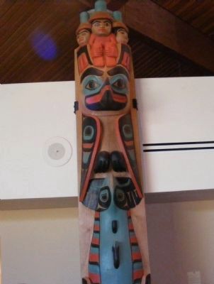
For thousands of years, water has been the common highway for all Northwest Coast Natives. Living at the edge of dense rain forests of great cedar, spruce, and hemlock along one of the world's richest sea coasts, their dependence upon seafood . . . — — Map (db m181977) HM
[Left side, top to bottom]
(Top photo) Illegible
The young city of Ketchikan (remainder illegible)
The Sideboard Saloon was operated by town co-founder Mike Martin from early in the century until 1917, when the . . . — — Map (db m181993) HM
Hundreds of proud sailing vessels once plied Alaskan waters, but the passing of the wail was swift & complete. As the new Era of the Steamship began to dominate the sea lanes in the late 1890's, Alaska's booming early salmon trade inspired the . . . — — Map (db m181943) HM
Prior to the 1870s, only a hardy handful of explorers, traders, whalers and sealers worked Alaska's rugged coastline. Following the 1867 purchase of the Territory from Russia, regular boat service from U.S. ports to Sitka began on a monthly . . . — — Map (db m181965) HM
Widely used today on the Yukon and Copper Rivers, the fishwheel was introduced in Alaska near the turn of the 20th century. It is thought to have been prominent in the Pacific Northwest, particularly the Columbia River, prior to making its way to . . . — — Map (db m173903) HM