Over the years, these grounds contained a variety of buildings that supported the Lighthouse operation. As you look around, envision the oil storage house with a greenhouse and sheds behind it, a square brick building housing the Weather Bureau . . . — — Map (db m46297) HM
Weather Bureau
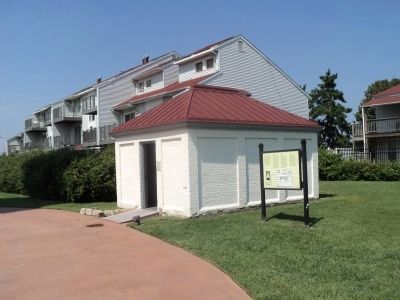
The Department of Agriculture Weather Bureau constructed a two-story brick building on the west side of the site in 1901. The building was wedged onto a 100 × 50 foot plot, and apparently caused rancor between employees of . . . — — Map (db m190905) HM
When Absecon Lighthouse was first lit in 1857, a principal keeper and assistant keeper lived on site with their families. The dwelling for an assistant keeper was built during the original Lighthouse construction. Interior alterations in 1887 . . . — — Map (db m46288) HM
1854. After a decade of prompting from Jonathan Pitney, the "father of Atlantic City," the U.S. Congress appropriated $35,000 to build a lighthouse on Absecon Island.
December 5, 1854. The Camden and Atlantic Land Co. transferred the . . . — — Map (db m190910) HM
March 6 1932
Five Coast Guardsmen from the Atlantic City Station lost at sea in an attempt to locate the fishing vessel "Anna"
John Barnett, Bay Head •
William Garton •
Charles Graham •
Hal Livingston •
Marvin E. . . . — — Map (db m190483) HM
The original membership who charted the course and had the vision and confidence to preserve the tradition of the sea in the restoration of historic Gardener's Basin in Atlantic City, New Jersey
Admiral of the Fleet
Atlantic . . . — — Map (db m190903) HM
Between 1900 and the early 1950s, African-Americans were socially restricted to use the Missouri Avenue Beach Area.
Since many vacationing Black families arrived with chicken-laden hampers, the strip became affectionately named “Chicken Bone . . . — — Map (db m36900) HM
"Despite what happened to me, in many ways I feel very lucky. If I had my stroke [at age 28], I think I would have just lived on and on without really doing anything interesting or challenging with my life. I've been through good times and bad . . . — — Map (db m153475) HM
The light from Absecon Lighthouse first beamed out across the Atlantic Ocean in 1857. At that time, the Lighthouse consisted of the original keeper’s dwelling, a thirty-foot connecting passageway and the tower. In 1903, adding a two-story . . . — — Map (db m46304) HM
The ocean waters off Absecon Inlet were considered some of the most deadly along the East Coast. Between 1847 and 1856, at least sixty-four ocean-going ships were lost off the coast of Absecon Beach. Dr. Jonathan Pitney, who promoted the . . . — — Map (db m46273) HM
By 1872, the first life-saving station was in operation on the corner of the Lighthouse property. This simple building, with some periodic renovations, served until the second, larger and more ornate station was constructed in 1884.
The new . . . — — Map (db m46289) HM
Before construction of Absecon Lighthouse, many ships and many lives were lost off the coast of Absecon Island. Even though the beam from this light lessened these losses, other disasters plagued seagoing vessels. The anchor you see here, weighing . . . — — Map (db m46291) HM
USCS Steamer Robert J. Walker
1874 - 1860
More than 153 years after it was lost in a violent collision at sea, the wreck of the steamer Robert J. Walker was identified 12 miles off Absecon Lighthouse by maritime . . . — — Map (db m190904) HM
This iconic symbol of Brigantine, NJ is not an actual working lighthouse but rather a monument or tourist attraction used to help in the sale of real estate on the island. The Lighthouse, which was built in 1926 by The Island Development Company, . . . — — Map (db m190485) HM
Gaskill Park was named for Burton Gaskill, a prominent Atlantic County leader, born in Mays Landing in 1889. It was built on land reclaimed by a W.P.A. project in 1937. Historically, it was the site of George Wheaton's shipyard. The West Jersey and . . . — — Map (db m190888) HM
Shipbuilding developed in this area at an early period, probably between 1720-1750. George May lived near this spot and is alleged to have built sloops here prior to the Revolution. According to the Penna. Packet, an early shipyard was here in 1779. . . . — — Map (db m92340) HM
In 1992 Congress passed a Public Law 102-536 which designated segments of the Great Egg Harbor River and its tributaries in the State of New Jersey as components of the National Wild and Scenic River System. The designation of 129 miles of the . . . — — Map (db m190892) HM
This boat is typical of the barges used to carry bog iron ore to the Batsto Furnace. It is estimated to be 150 years old and is 43 ft. long, with an 11 ft. beam. The boat was excavated from the north side of the Batsto Dam in 1957. — — Map (db m76159) HM
While the Batsto Dam provided power to a once prospering village, it halted the natural migration of spawning fish. The Batsto River Fishway Project provides a pathway over the dam. This project improves the aquatic ecosystem and provides increased . . . — — Map (db m76157) HM
Great Egg
Coast Guard Station
has been listed in the
National Register
of Historic Places
by the United States
Department of the Interior
— — Map (db m153613) HM
On this day, Tropical Cyclone Sandy caused tidal flooding to rise to this level at this location! Tidal height was 8.8 ft. above Mean Lower Low Water
Be aware. Prepare. — — Map (db m153616) HM
Transportation and the Development of Tourism in Ocean City
Ocean City was founded in 1879 as a permanent community and seaside Christian resort where residents and summer visitors could enjoy physical and spiritual rejuvenation at the . . . — — Map (db m153625) HM
World War Memorial Bridge Design
The World War Memorial Bridge over Ship Channel was a 47-span vehicular bridge designed to carry two lanes of traffic in each direction. The bridge measured 1,442 feet long and 40.3 feet wide. As shown in . . . — — Map (db m153628) HM
Time has taken its toll on the disappearing act of full "bathing costumes." Back in the early 1900s, women wore black, knee-length, puffy sleeved wool dresses. But times began to change and soon women began wearing less and less. In 1945, Louis . . . — — Map (db m153596) HM
Erection of the first boardwalk began in 1905 and was completed in 1910. The Ventnor Fishing Pier was completed in the late 1920s and was originally free admission. Soon after overcrowding forced authorities to make admission by membership card . . . — — Map (db m153607) HM
Ventnor City Hall was built by engineer Vivian B. Smith in 1929, who designed the building to harmonize with the surrounding residences. The structure served the dual purpose of a municipal office building, assembly hall and headquarters for the . . . — — Map (db m153606) HM
Former Ventnor City Lifeguard and Rowing Champion Dr. John W. Holland started the Viking Rowing Club in 1959. A few years later sculling and sweeping (crew) were introduced as the new sport. The Club, located in Ventnor Heights, operates programs . . . — — Map (db m153601) HM
In the time of the revolution, the road turned here and followed the brook to Peter Burdett’s ferry, the important Hudson River approach to General Nathaniel Greene’s encampment at Fort Lee, on the hill, and the connecting link with the American . . . — — Map (db m22101) HM
Built for the Hoboken Ferry Company and launched in 1905, it plied the Hudson River between Hoboken and Manhattan (Barclay St.) for 62 years. This double-ender steamboat was designed to carry 986 passengers and a number of vehicles. It was in . . . — — Map (db m9528) HM
General Washington was in Fort Lee many times during the Battle of New York. His main headquarters was in Hackensack, but had a temporary headquarters in Fort Lee near Anderson Avenue and Elizabeth Street. His main objective in Fort Lee was to . . . — — Map (db m7647) HM
General Knox was the Commander of the Continental Army Artillery. He was in charge of the placement of the artillery cannons on the palisades in Fort Lee. His main objective was to stop the British fleet from sailing up the Hudson River. He was one . . . — — Map (db m7650) HM
General Greene took command of Fort Lee on September 17, 1776 from General James Iwing. At that time there were around 2,667 troops stationed in Fort Lee. The encampment was the main quartermaster post for supplying men and equipment to Fort . . . — — Map (db m7648) HM
Known to the Indians as “Michanagrape,” these waters were formed by the melting glacier some 10,000 years ago. In 1700 the lake was named Christian Pool when it was included in a land grant to Michael Hawden. Later called Great Pond, . . . — — Map (db m52941) HM
This Bell
Symbolic of Freedom
is the gift of
The Navy Department
to the Borough of Glen Rock
December 1954
From the Destroyer USS Lang (DD 399)
a veteran of ten operations
World War II; named in memory of
Seaman James Lang, . . . — — Map (db m209463) HM WM
U.S. Navy submarines paid heavily for their success in World War II. A total of 374 officers and 3131 men are on board these 52 U.S. Submarines still on “patrol.” Albacore • Amberjack • Argonaut • Barbel • Bonefish • Bullhead • Capelin . . . — — Map (db m108413) HM
Launched August 15, 1943
Commissioned – June 8, 1945 – Boston
Sponsor Mrs. Edward J. Foy
First Captain – Commander G. G. Molumphy — — Map (db m108414) HM
This type of mine was deployed from surface ships and submarines. The larger round section of the mine contains 600 lbs of cast TNT. When the enemy ship moves near the mine, the smaller float makes contact and sets off the detonator. The main . . . — — Map (db m108424) HM
Commissioned November 22, 1939 U.S. Navy Yard Mare Island, Calif. Over Due – Lost May 1944 In memory of 78 officers and men By sinking a Japanese submarine on January 27, 1942, she became the first U.S. submarine in . . . — — Map (db m64467) HM
Built about 1840 in the Greek Revival Style of architecture by John C. Demarest. He was a farmer with an interest in river trade when schooners plied the Hackensack River. The house was purchased in 1864 by George Bloomer, a dealer in coal and . . . — — Map (db m7226) HM
Dedicated in Honor of Christopher Columbus who had the courage to venture out into uncharted waters and discover America.
Presented to the Borough of North Arlington on October 12, 1992 by the North Arlington Chapter of Unico National on the . . . — — Map (db m6737) HM
The Continental Army is reported to have utilized the old spring at the base of these slopes during the September encampment west of the Hackensack River. Reports indicate that General Washington visited here and drank water from the spring. — — Map (db m8413) HM
Howland Avenue divided the farms of miller Cornelius Van Saun to the south and Christian Dederer to the north. Hendrick Banta lived west of Mill Creek. The Continental Army moved into Bergen County in August 1780 to forage for food and to await the . . . — — Map (db m8412) HM
Site of the Zabriskie Grist Mill and wharf near the head of navigation on the Hackensack River. Farm produce and iron from the Ramapo Mts. were shipped from here to market. The mill, once powered by the tides, burned in 1852 after a century of . . . — — Map (db m7468) HM
About 1710, David Ackerman built the New Bridge gristmill. In 1752, Annetje Acerman and Jan Zabriskie built the Zabriskie-Steuben House. First Bridge Above Newark Bay
The 1744 drawbridge over the Hackensack River at New Bridge could have . . . — — Map (db m186580) HM
In Honor Of
USS Enterprise (CV-6)
1938-1947
20 Battle Stars World War II
Presidential Unit Citation
Navy Unit Commendation
Most battle stars awarded to any World War II ship. Only fast carrier to be awarded both the Presidential Unit . . . — — Map (db m113981) WM
USS Enterprise (CV-6)
Stern Plate
Mr. Henry Hoffman, the engineer responsible for the dismantling of the Enterprise between 1958 and 1960, had the foresight to recognize the historical significance of the Aircraft Carrier’s stern plate. In 1959 . . . — — Map (db m113980) WM
Erected by Joseph Dubois in the locality once known as Rockland Neighborhood. South wing built in 1835, with materials from 18th century house of John Gesner. Center section built soon after with Victorian porch and north wing added at a later . . . — — Map (db m8680) HM
Route 3 Bridge at the Passaic RiverThe Route 3 Bridge over the Passaic River, completed in 1949, was a 7-span, 699 foot long, 76 foot wide, double leaf bascule, simple trunnion movable bridge. It consisted of a twin-double leaf main span, two . . . — — Map (db m83168) HM
Bordentown began as a small river port known as Farnsworth's Landing in the 1680s. Over the next two hundred years it became a nexus for boat and statecoach traffic between Philadelphia and points north. This location had two major strategic . . . — — Map (db m160167) HM
Located at the confluence of the Delaware River and Crosswicks Creek. Farnsworth's Landing provided an ideal site for a colonial village.
From the 1682 Trading Post to the bustling terminus of the Camden and Amboy Railroad, . . . — — Map (db m160148) HM
Waters of Crosswicks Creek and the Delaware River join below. 22 vessels at Bordentown and 4 at White Hill were among the 44 that were destroyed in a British raid on May 8, 1778. All were trapped in the Upper Delaware when the British took . . . — — Map (db m5336) HM
About Abbott Marshlands
The Abbott Marshlands — 3,000 acres of forests, ponds, and wetlands — exist today within one of the most populated regions of the United States. Named after naturalist and archaeologist Charles Conrad Abbott, these . . . — — Map (db m212540) HM
Chartered simultaneously in 1830, the Camden and Amboy (C&A) Railroad and the Delaware and Raritan Canal formed one of New Jersey's most significant early transportation networks. The D&R was one of this country's busiest navigation systems for . . . — — Map (db m160171) HM
The 330-mile Delaware River is the longest free-flowing river east of the Mississippi River is the longest free-flowing river east of the Mississippi River. Its watershed drains an area of 14,119 square miles in four states. This nationally . . . — — Map (db m160163) HM
Since the 1600s, Burlingtonians have enjoyed a close relationship with the Delaware River and surrounding creeks, streams, and ponds. As much as for travel and shipping, the Delaware River presented locals and visitors ample opportunity for . . . — — Map (db m160098) HM
At first the Delaware River carried people and goods to and from the City of Burlington. Farm goods and raw materials were transported by horse-drawn wagons on coarse roads to the busy markets and wharves at the foot of High Street.
Finished . . . — — Map (db m79545) HM
West New Jersey Proprietors
To commemorate
The Founding of Burlington
in 1677 and the
Mooring of the ship 'Shield'
near this spot in 1678
This tablet is erected by the Society of
Colonial Wars in the State of New Jersey
on the two . . . — — Map (db m33870) HM
Riverside-Delanco
Bridge
Over The Rancocas Creek
dedicated as the
Landon-Stone
Memorial Bridge
Opened September 14, 1935
First bridge 1870
Second bridge 1901 — — Map (db m194821) HM
Fieldsboro, incorporated in 1850, is the smallest municipality in Burlington County. Early land records identify the area as White Hill. One of its early settlers was Robert Field, who owned a wharf on the Delaware River, several businesses and a . . . — — Map (db m160138) HM
This was the head of navigation on the Rancocas. Before 1800 iron and charcoal were unloaded here from wagon to barge for shipment to Philadelphia. 1847-1997 — — Map (db m45026) HM
In 1920 Lake Pine was a cranberry bog and Taunton Blvd was a sand road. This log cabin, built in 1926, was converted from a summer cottage to year-round, c. 1950. — — Map (db m45022) HM
Points of Interest
105 Griffith Morgan House, a ca. 1693 native sandstone farmhouse, may be the oldest surviving house in Camden County. On the National Register of Historic Places, it is maintained as a public historic site by a . . . — — Map (db m194890) HM
Riverton was established by ten wealthy Philadelphia merchants in 1851. They bought a large riverside section of Joseph Lippincott's farm, selected sites for their summer homes and divided the rest into lots to be sold. The founders hired noted . . . — — Map (db m194846) HM
The face of Riverton, then and now
In 1851, travel on rough dirt roads and primitive, sooty railroads was unpleasant - but steamboats on the river were fast and smooth.
Riverton was laid out with the steamboat pier as the . . . — — Map (db m194880) HM
The Navigation Bridge is where the crew of New Jersey "conned," or steered, the ship. This operation required the coordination of the ship's helmsmen, Officer of the deck, and navigational crew. Located on the Navigation Bridge was the . . . — — Map (db m221030) HM
New Jersey's secondary armament originally consisted of twenty 5-inch/38-caliber guns in ten twin enclosed gun mounts. Two mounts were located on each side of the ship at the 01 Level and three were mounted on each side at the 02 Level. These . . . — — Map (db m221038) HM
Over the course of her four commissions, New Jersey was the flagship for some of the most famous Admirals in U.S. Navy history. From World War II to Vietnam, this area was part of the Flag Cabin where these naval legends worked and lived . . . — — Map (db m221006) HM
The Flag Bridge was reserved for use by admirals. Here, an admiral could command any fleet or fleets arrayed around New Jersey. While the admiral was in overall command of the fleet, New Jersey's captain was directly responsible for the . . . — — Map (db m221019) HM
The Flag Bridge was reserved for use by admirals. Here, an admiral could command any fleet or fleets arrayed around New Jersey. While the admiral was in overall command of the fleet, New Jersey's captain was directly responsible for the . . . — — Map (db m221021) HM
When the USS New Jersey (BB-62) was designed in the late 1930's, aiming a warship's guns was still being carried out the same way it had been for centuries: by visual spotting.
An observer would "spot the fall of shot," or observe . . . — — Map (db m221032) HM
The USS New Jersey (BB-62) launched from the Philadelphia Naval Shipyard on December 7, 1942, and served in World War II, the Korean War, the Vietnam War, and as part of a multinational force of peacekeepers during the Lebanese Civil War. She was . . . — — Map (db m133527) HM WM
During World War II, the USS New Jersey was armed with over eighty medium and fifty 20mm anti-aircraft guns against an air attack. By 1982, these guns were replaced with four Phalanx Close-In Weapons System (CIWS). CIWS, pronounced . . . — — Map (db m221036) HM
This massive gun barrel sitting before you was once mounted inside Turret 1 of the battleship USS New Jersey. During the epic battles of World War II and the Korean War this gun barrel, along with the other guns and brave crew of New Jersey, . . . — — Map (db m133525) HM WM
"There are no great men, there are only great challenges, which ordinary men like you and me are forced by circumstances to meet."
- FADM William Frederick Halsey Jr.
Born: October 30, 1882
Died: August 16, . . . — — Map (db m220974) HM
Fleet Admiral William Halsey is one of the most important and controversial figures in the history of the U.S. Navy.
In 1944, onboard New Jersey from the area you are standing, Halsey commanded the world's largest naval combat fleet ever . . . — — Map (db m221029) HM
First deployed in 1977, the RGM-84 Harpoon is an all-weather anti-ship missile developed for fleet-wide use. Harpoon is 15 feet in length and propelled by a turbojet motor burning aircraft fuel generating 660lbs. of thrust. Armed with a . . . — — Map (db m133789) HM
Two Marines fire an M2 during gunnery practice on the Battleship Missouri (BB-63) in 1987. The M2 machine guns on Battleship New Jersey (BB-62) were operated in the same manner. Sand bags could be placed around the gun mount to provide additional . . . — — Map (db m133782) HM WM
The USS New Jersey was outfitted with the Mark 36 Super Rapid Bloom Offboard Chaff, or SRBOC (pronounced super arboc), during her modernization in the 1980s, as were all the Iowa-class battleships.
Working in conjunction with the . . . — — Map (db m221037) HM
The USS New Jersey (BB-62) carried small boats to transfer officers and crewmembers to and from ships or points onshore. When visiting less-developed or shallow ports of call where USS New Jersey (BB-62) could not moor to a pier, . . . — — Map (db m221005) HM
Standing 5 stories high, this side view shows the massive size of the 2,050 Ton 16 inch Gun Turret. It took a crew of 77 sailors to load and fire this three rifle Gun Turret. Capable of firing one 1,900 lb. High Capacity or one 2,700 lb. Armor . . . — — Map (db m133786) HM WM
Wooden decks were used on battleships as part of a long navy tradition. Steel decks of the USS New Jersey were overlaid with Teakwood planks. The New Jersey had her original Teakwood deck laid in 1943 for WWII. There have been repairs to the deck . . . — — Map (db m220987) HM
During the early years of World War II, enemy attacks seriously crippled our Merchant Fleet, preventing them from carrying troops and vital military supplies, equipment, and fuel to the battlefront. President Franklin Roosevelt organized an . . . — — Map (db m220930) HM
The connection between the USS New Jersey (BB-62) and the State of New Jersey goes far beyond just sharing a name. The longest battleship in the world, and the most decorated in our nation's history, was launched a few miles from this spot . . . — — Map (db m220931) HM
"Our greatest weakness lies in giving up. The most certain way to succeed is always to try just one more time."
- Thomas Edison
Born: February 11, 1847
Died: October 18, 1931
Lived and worked in: . . . — — Map (db m220972) HM
The U.S. Merchant Marine was a fleet of Government owned vessels operated by private shipping companies. The Merchant Marine was responsible for transporting fully 85% of the troops, ammunition and supplies used to support the Allied War Effort . . . — — Map (db m220919) HM
The evolution of battleships in the early 20th century resulted in big guns that could hit a target beyond visual range. In 1929 the U.S. Navy began equipping new battleship designs with spotter aircraft to scout targets and assist in directing . . . — — Map (db m133790) HM WM
Dedicated to the memory of the Marines of the Marine Detachments that served aboard the USS New Jersey from 1942–1991
Semper Fidelis — — Map (db m7432) WM