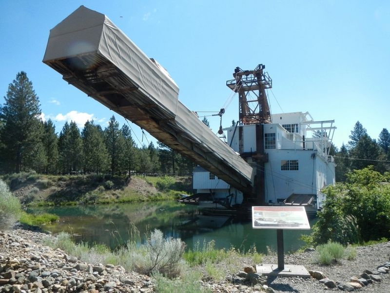
As you look at the tailings in an aerial photograph or along the road, you'll see that they're played out in neat lines. Why are they straight? Because the dredge had an "anchor" to keep it going forward in a line, rather than wandering over the . . . — — Map (db m111245) HM
The first steamboat to reach Corvallis was the sidewheeler Canemah in October of 1851. With this arrival, Corvallis joined Oregon's steamboat era, with tis stories of risk, profit, rivalries, mergers, heroics, innovation and disasters. . . . — — Map (db m117465) HM
Site of the earliest boat landing Lower Town, Marysville, 1851 Presented to City of Corvallis, Oregon Centennial Celebration, June 1957 by the Winema Chapter Daughters of the American Revolution — — Map (db m107333) HM
Ferry service across the Willamette River was established by William F. Dixon, co-founder of Corvallis, in 1848. The service continued for 65 years until the opening of the Van Buren Street Bridge in 1913.
In the 1860s, the ferry was operated . . . — — Map (db m117447) HM
In the early 19th century, the river landing at the mouth of Oswego Creek was a convenient camping place for explorers, fur traders, and pioneers. In the words of one old timer, it was "a stopping place, a sort of a relay station for boats both . . . — — Map (db m121328) HM
Lot Whitcomb, proprietor of the town, gave two lots and an unfinished building that had cost him about $1,000 - the first Episcopal church building in Oregon.
His wife, Irene, suffered from asthma. Believing Oregon a healthy place, in . . . — — Map (db m114171) HM
Still in use below this point-were opened on New Years Day, 1873, when the steamer Maria Wilkins became the first vessel to navigate up the west end of Willamette Falls. Farming and shipping interests had long sought to eliminate expensive portages . . . — — Map (db m8667) HM
Many of Oregon’s early transportation routes resulted from the efforts of enterprising pioneers like the Boone family of Clackamas County. In 1846 Alphonso Boone, grandson of Daniel Boone, emigrated to Oregon via the Applegate Trail with his large . . . — — Map (db m127162) HM
The Oregon Electric Railway was completed during the first decade of the 1900s, coming initially from Portland to Wilsonville, then on to Salem and Eugene after construction of a mile-long trestle across the Willamette River was completed in 1907. . . . — — Map (db m127219) HM
Lt. Neil M. Howison, U.S.N., arrived in the Columbia River 1 July, 1846 on board the 300-ton United States Naval Survey Schooner "Shark" for the purpose of making an investigation of part of the Oregon Country. His report was instrumental in . . . — — Map (db m113513) HM
Cannon Beach was named after a carronade (a short, smoothbore, cast iron naval cannon) found buried in the sand nearby. The cannon broke free of the USS Shark's deck during a shipwreck at the mouth of the Columbia River on September 10, 1846. . . . — — Map (db m177304) HM
The Corps of Discovery traveled thousands of miles and endured many hardships to reach the Pacific Ocean in mid-November 1895. The last sixteen miles down the Columbia River took ten days because of bad weather. The explorers huddled among the rocks . . . — — Map (db m113006) HM
In 1921, responding to increasing popularity of travel by automobile, Captain Fritz Elfving formed the Astoria-North Beach Ferry Company to transport passengers and cars across the Columbia River.
His ferry slip on the Oregon side of the river . . . — — Map (db m113269) HM
The Columbia River is a highway for huge amounts of freight. The most frequent outbound cargoes include wheat and other agricultural products from the inland Northwest, logs and lumber, and mining products like coke or potash. Entering the river, . . . — — Map (db m113238) HM
Before the fire of 1922, much of downtown Astoria was built on pilings over the river. People built out from the original hilly shoreline, creating a level commercial district with access to the water.
Every type of business might be . . . — — Map (db m113237) HM
The oldest American settlement west of the Rocky Mountains, dating back to Lewis & Clark.
Explore our history, natural beauty and opportunities for adventure.
For free maps and visitor information, visit one of the Astoria-Warrenton . . . — — Map (db m113011) HM
The oldest American settlement west of the Rocky Mountains, dating back to Lewis & Clark. Explore our history, natural beauty and opportunities for adventure. For free maps and visitor information, visit one of the Astoria-Warrenton Chamber Welcome . . . — — Map (db m177306) HM
People have always turned to the river for enjoyment and just plain fun. Today you may see recreational sailboats, motorboats, jet-skis, kayaks, cruise ships, windsurfers, or kiteboards sharing the river with huge commercial ships.
In the . . . — — Map (db m113250) HM
The Columbia River Bar is considered by professional mariners to be the most dangerous bar crossing on the planet.
The Pilot Boat Peacock was built in 1964 based on a German North Sea rescue boat design.
Put into service on the . . . — — Map (db m112994) HM
Towboats began working on the Columbia in the mid 19th century.
Powerful steam tugs towed sailing vessels over the Columbia River bar.
Sternwheel steamboats, many of which operated as tugs, plied the entire Columbia River system.
During . . . — — Map (db m113234) HM
For thousands of years, Native Americans thrived on salmon fishing on the Columbia River. They traded dried fish with other native people all over the west. In the 1870s, later settlers also made commercial fishing a way of life. It remains a . . . — — Map (db m113239) HM
Well after the end of the American Revolution, this vast river we call the Columbia and the entire Northwest Coast were still only vague lines on even the best European maps. But the region was home to native peoples whose ancestors had lived . . . — — Map (db m113236) HM
The Pilot Boat Peacock was built to meet the challenging conditions at the mouth of the Columbia River. Pilots transferred to and from ships by means of the retrievable daughter boat off the stern. The vessel is based on a North Sea rescue . . . — — Map (db m112995) HM
The mouth of the Columbia River is known to mariners as one of the most hazardous crossings in the world.
Large ocean-going vessels rely upon highly skilled pilots to bring them across the bar and then to guide them safely to ports up and down . . . — — Map (db m113233) HM
Before engines - they fished in boats powered by the wind in their sails & were called the Butterfly Fleet. They were at the mercy of the wind & tides & as such it was a very dangerous profession. They did not always come back - these predominantly . . . — — Map (db m113566) HM
The Corps of Discovery entered the marshes and sloughs of the Columbia's estuary in early November of 1805, but violent weather pinned them down along the river's banks for days. While camped across the river William Clark lamented, O! how . . . — — Map (db m113582) HM
In 1804-06, Captains Meriwether Lewis and William Clark led about 40 soldiers and boatmen on an epic journey. President Thomas Jefferson commissioned this "Corps of Discovery" to find a route to the Pacific Ocean through the newly acquired Louisiana . . . — — Map (db m114094) HM
Camping on the Clearwater River in present-day Idaho, the Corps of Discovery made dugout canoes from pine logs. For expediency, Sergeant Patrick Gass noted: "we have adopted the Indian method of burning out the canoes." Axes and adzes were . . . — — Map (db m113556) HM
Named after the cannon washed ashore on this beach from the U.S.S. Sloop of War 'Shark' which was wrecked while attempting to leave the Columbia River Sep't. 10, 1846.
This replica erected by the Cannon Beach Commercial Club Dec. 15, 1952. — — Map (db m113596) HM
Technology in Transition
The Peter Iredale was built in 1890 during the transitional period before wooden sail powered vessels were replaced with all metal steamships. Advances in iron and steel forging marked the start of . . . — — Map (db m113586) HM
On October 25, 1906, with an empty cargo hold and only 28 days out of Salina Cruz Mexico, the Peter Iredale ran aground. Bound for Portland and a new load of cargo, Captain H. Lawrence offered his crew a bonus if they cut five days off the . . . — — Map (db m113584) HM
Deer Island in the Columbia was named by the Lewis and Clark Expedition which stopped to dine here November 5, 1805 on its way down river. Homeward bound the explorers camped on the island on March 28,1806. Captain Clark recorded "This morning we . . . — — Map (db m194989) HM
Lewis & Clark on the Columbia River
The Lewis and Clark Expedition made the first documented descent of the Columbia from the mouth of the Snake River to the Pacific.
This voyage strengthened the claim of the young United States to . . . — — Map (db m113157) HM
Lewis & Clark and the Corps of Discovery
In 1803, the United States purchased the Louisiana Territory from France, expanding this country from the Mississippi River west to the Rocky Mountains and from the Gulf of Mexico north to . . . — — Map (db m113159) HM
In 1804-06, Captains Meriwether Lewis and William Clark led 31 men and one dog on an epic journey.
President Thomas Jefferson commissioned this "Corps of Discovery" to find a route to the Pacific Ocean through the newly acquired Louisiana . . . — — Map (db m113155) HM
In October 1856, the U.S. Lighthouse Board entered this fog bell and Cape Disappointment Lighthouse into service, thus establishing the first light station on the Oregon and Washington coast.
Positioned on the north side of the entrance to . . . — — Map (db m113153) HM
In the year 1874 on this and adjoining
property Captain Judah Parker and
partners built and operated the first
steam sawmill and steam tug on the
Coquille River. A year later Captain
Parker, with the assistance of the
settlers and farmers . . . — — Map (db m73228) HM
The 27-foot tug named Irene was built in 1938 by a family friend, C.J. Sessions, for Henry Sause, Sr. and Curtis Sause.
It was designed along the lines of a Columbia River gillnetter with a four-cylinder, 40 horsepower Durant automobile . . . — — Map (db m114195) HM
Working On Water
Koos No. 2 was the second of several tugboats with the Koos name to work for the Knutson Towboat Company.
Built in 1924 by Frank Lowe at his Marshfield shipyard, Koos No. 2 went to work with her . . . — — Map (db m114186) HM
The tugboats of the Coos Bay waterways work on shipping related jobs of towing log rafts, moving big ships in and out of harbor, and moving barges.
Coos Bay is more than a port – it’s also an estuary. Estuaries are places where . . . — — Map (db m114184) HM
The Devon privateer took his flotilla from Plymouth Harbor August 5, 1577 bound for the River Plate.
He raided Spanish shipping and treasure houses around South America, including Valparaiso, Peru and Acapulco roads.
June 5, 1579 the renamed 78 . . . — — Map (db m114250) HM
The shipping channel in the bay in front of you has a depth of about 35 feet at low tide. Large ships travel in this channel on their way to the upper bay.
Frequently small harbor tugs can be seen pulling log rafts by this pavilion. The . . . — — Map (db m114152) HM
Today, the Coos Bay harbor continues to serve as a connection to the rest of the world, and as a working waterfront.
In addition, it has become a source of identity for the people living near its waters.
The timber industry . . . — — Map (db m114153) HM
On the beach west of here the U.S. Transport Captain Lincoln was beached at high tide during a storm. The soldiers and crew built a camp from the sails under the trees across the bay from this spot and made a flag pole from a mast from which Old . . . — — Map (db m241038) HM
Travel by land was difficult until about 1915.
The road between Marshfield and North Bend was not completed until 1912. Most people continued to travel by small boats around Coos Bay for several more years.
Mosquito Fleet
. . . — — Map (db m114148) HM
Most travel was on water;
roads and rail lines were limited in the early days.
Passenger ships called at the Port of Coos Bay regularly.
Travel by water was faster, and much more predictable than by land.
In the early . . . — — Map (db m114149) HM
In 1872, the Coos Bay Wagon Road was completed.
The road, which connected Coos Bay Roseburg, was 58 miles long. A stagecoach could make the trip in about 28 hours in good weather.
Another route to the interior was the stage . . . — — Map (db m114150) HM
First Came Steam -
The first tugboats in the Coos Bay area had steam engines, and steam powered tugs were in service up to the 1950s.
Steam power had some advantages: wood and coal to burn to make steam were abundant and cheap, and . . . — — Map (db m114189) HM
The first tugs on Coos Bay were steam-powered, usually towing log rafts or piloting sailing ships in and out of port.
Gasoline and diesel internal combustion engines arrived in the early 1900s and began to replace steam engines. By . . . — — Map (db m114182) HM
A boat designed to push or tow.
Tugboats have a lot of power and are versatile. A tug can push or tow something a lot bigger than itself and can go backward or sideways almost as well as forward.
Screw propellers are designed for . . . — — Map (db m114183) HM
In November, 1937, Buzz Holmstrom, a service station attendant from Coquille, became the first person to run the Green and Colorado Rivers alone. His eleven-hundred-mile solo journey in a handmade wooden boat brought him national acclaim. After . . . — — Map (db m120641) HM
On March 10, 2011 at 9:54pm (Pacific Standard Time), a 9.0 magnitude earthquake struck off the northeast coast of Japan creating a major tsunami event for the entire Pacific Ocean, including the West Coast of North America. Approximately nine hours . . . — — Map (db m128328) HM
Gold discovered on the beaches at the mouth of Rogue River in the mid-1800s brought miners here; resulted in the Rogue River Indian Wars of 1855-56.
Prattsville, Ellensburg, officially becoming Gold Beach in 1890.
In the 60’s returns from . . . — — Map (db m113220) HM
In 1876 Mr. R.D. Hume of Astoria, Oregon, decided to move his commercial salmon fishing, processing and shipping business to the mouth of the Rogue River. Mr. Hume anticipated huge profits due to the large run of "King" Salmon which entered the . . . — — Map (db m73202) HM
The Chetco people are the earliest known inhabitants of the Brookings-Harbor area. The Athabaskan-speaking people of Chit-xu and eight other Chetco group villages originally lived along this river and on the adjacent coast between the Winchuck River . . . — — Map (db m176835) HM
For thousands of years, the Sixes River has been a source of food, transportation, and fun for all who have lived here.
They called the river and the village at its mouth "Sekwetse," according to Coquille and Siletz Tribal sources. Sekwetse means . . . — — Map (db m176860) HM
On Feb. 10, 1937, winds over 75 M.P.H. caused the 190 foot steam schooner "Cottoneva" to run aground at Battle Rock. It was in port loading lumber. The captain and all 26 seamen were rescued by the Coast Guard crew using a breeches body. The . . . — — Map (db m73203) HM
In 1852, gold was found in the beach sands at Whiskey Run, about ten miles north of Bandon. Gold was also found on beaches at South Slough, Bandon, Cape Blanco, Port Orford, Ophir, Pistol River and Gold Beach>
Gold was washed onto the beaches by . . . — — Map (db m176822) HM
This cableway was installed in 1905 by the United States Geological Survey to measure the river's flow.
Today instruments sense and record the elevation of the water surface.
This information is relayed by satellite into computers of water . . . — — Map (db m114253) HM
Huge trees were felled in the woods and the logs were transported by railroad to town. They were then dropped into the Deschutes River to await their turn in the mill. The river was a perfect storage place for the logs. The natural flow of the . . . — — Map (db m113936) HM
On August 8th, 1850, the schooner Samuel Roberts grounded on this bar during her maiden voyage to Scottsburg as part of the Klamath exploring expedition.
She was the first recorded American Vessel to navigate the Umpqua River.
While waiting . . . — — Map (db m113339) HM
This former U.S. Coast Guard facility built in 1939, was restored by the Douglas County Park Department and dedicated as a public recreation facility on June 19, 1980.
Douglas County Board of Commissioners
Bill Vian, Chairman
. . . — — Map (db m113507) HM
Originally the first lighthouse in the Oregon Territory. Was built in 1857 near the mouth of the river.
It was undermined and destroyed by flood in Feb. 1864.
Rebuilt here in 1891 and completed in 1894.
It shines a guiding light to all . . . — — Map (db m113915) HM
(Seven panels dealing with the Columbia Plateau and Columbia River portions of the Oregon Trail are found at this kiosk)
Pathway to the "Garden of the World"
Excitement filled the air May 22, 1843 as nearly one thousand Americans left . . . — — Map (db m111946) HM
Water, the lifeblood of any working ranch, flows in irrigation ditches fed by rivers, creeks, or a steady spring or two. In this dry landscape, these human-made arteries, like the one before you, have made the rich soils of the flood plain . . . — — Map (db m158011) HM
You are standing in the middle of a lively watershed. Supporting a diverse community of aquatic and terrestrial life, the John Day River is the longest free-flowing river west of the Rocky Mountains, flowing over 280 miles to its mouth at the . . . — — Map (db m158071) HM
Elevation 5000 feet Surface 50 acres
Depth 98 feet.
Magone Lake was formed in the early 1800s by a landslide which dammed Lake Creek. Notice the tilted trees which rode down with the slide.
The lake was named for "Major" Magone and . . . — — Map (db m107489) HM
Migrating fish are attracted to large flows of water coming from the Bonneville Dam. To take advantage of this natural reaction, fish-collection facilities are placed along the face of the powerhouse and at each end of the spillway dam. These . . . — — Map (db m92686) HM
Thousands of Oregon Trail emigrant passed this way toward new lives in a place Abigail Scot, emigrant of 1852, called the "Garden of the World" The Willamette Valley was nearly 2,000 miles from Missouri, and by the time emigrants reached this . . . — — Map (db m158539) HM
Sturgeon range throughout the Columbia River system, however the construction of Bonneville Dam and the other dams upstream blocked sturgeon migration. Sturgeon, unlike salmon, do not use fish ladders. Sturgeon below Bonneville Dam travel up and . . . — — Map (db m92687) HM
Although steel has been made for centuries, it wasn’t until the Bessemer process was introduced in the 1870s that it could be produced in quantity.
The Bridge of the Gods mural is the creation of Larry Kangas, of Beaverton, . . . — — Map (db m112267) HM
Gale-force winds bedeviled explorers and emigrants alike in the Columbia River Gorge.
Journals from the 1800s depict travel as treacherous through this singular passage in the Cascade Range where 60 mile-per-hour gusts are common.
By . . . — — Map (db m113939) HM
Sternwheeler traffic on the Columbia River reached a fevered-pitch with the completion of Cascade Locks in 1896.
Steam-powered paddlewheelers provided a vital link between The Dalles and Portland.
The trip averaged six hours on a good day, and . . . — — Map (db m113947) HM
The first ferry near this site was established before 1854 by T. Thompson. It was known as Hailey’s Ferry, 1855-1860. William Bybee operated the ferry from 1863 to 1886, when the first Bybee Bridge was constructed. — — Map (db m113867) HM
Davis Evans established the first ferry this site in 1851. It was known as Jewett's Ferry, 1853-1861. The 1862 flood destroyed the ferry, but it was replaced. The Woodville (Rogue River) Bridge was built in 1909. — — Map (db m112488) HM
Canyon Formation
Constant flow of water over the volcanic basalt rock carved the 2,100-foot long canyon. With no way for the water to expand to the sides, the river bed was forced to depths of about 100 feet.
Evolution of . . . — — Map (db m112805) HM
At this narrow point where Lost River flows westerly toward Tule Lake, there is a conjunction of historical events. "Olene" in the Klamath (native American) language means "eddy place." For hundreds, perhaps thousands of years, this site was an . . . — — Map (db m112891) HM
Rafted lumber down Upper Klamath Lake and
built first buildings on this site, 1867.
Registered first official plat of town, 1878.
Was Linkville's first hotel keeper, postmaster,
and livery stable operator. Gave building lots
to people who . . . — — Map (db m113638) HM
This is Oregon's largest body of water, about 90,000 acres. Indians inhabiting its shores ("People of the Lake") lived well on wild fowl, fish and wocus seeds. The first known white visitors (1825-26) were Hudson's Bay trappers under Tom McKay and . . . — — Map (db m100204) HM
This is Oregon's largest body of water, about 90,000 acres. Indians inhabiting its shores ("People of the Lake") lived well on wild fowl, fish and wocus seeds. The first known white visitors (1825-26) were Hudson's Bay trappers under Tom McKay and . . . — — Map (db m112525) HM
Can you feel the sea wind?
The lighthouse can, too!
For a lighthouse, standing out in the sea spray and storm winds is part of the job description.
For more than a century of working life, Heceta Head Lighthouse has taken a . . . — — Map (db m113303) HM
From top to bottom, Heceta Head Lighthouse
is built to guide from afar.
The light’s height was most likely chosen to maximize its range while minimizing the chances it would be hidden by fog.
Unlike most Fresnel lenses of the day, . . . — — Map (db m113304) HM
Early industries in the Florence area were built on the natural resources that the Siuslaw River Valley had to offer. The rivers were filled with swarming salmon and the forests held acres of old growth timber. Those abundant natural resources . . . — — Map (db m93894) HM
Would you make it as a
Heceta Head Lighthouse keeper?
Imagine living here, part of a tiny, isolated community whose lives revolved around the beacon of Heceta Head Light. You would:
Work day and night to keep the light in good . . . — — Map (db m113305) HM
Lighthouses are not just scenic structures – they are life-saving innovations.
In the 19th century, most traffic sailed by offshore. To steer true, and to avoid hazards such as reefs and shoals, ship captains needed land-based . . . — — Map (db m113916) HM
The connection to the Pacific Ocean by way of the Siuslaw River made Florence a natural hub for industry. The shifting river channel and mouth made early navigation unpredictable. The lack of stable conditions made establishing a thriving harbor . . . — — Map (db m93912) HM
The Siuslaw River Bridge was built as part of the Coast Bridges Project.
It is one of five designed by Conde B. McCullough and built during the Great Depression from 1934 to 1936.
The Coast Bridges Project was funded through the Public Works . . . — — Map (db m113260) HM
Constructing Over the Siuslaw
The Siuslaw River Bridge incorporates Art Deco, Moderne, Gothic, and Egyptian influence that were important to McCullough. Due to its ability to open at the center, the Siuslaw River Bridge best represents . . . — — Map (db m113537) HM
In Oregon's early days, emigrants came in droves to live along the Willamette River, but they soon discovered its volatile nature. Floods inundated the valley, property was destroyed, and lives were lost. The Army Corps of Engineers was given the . . . — — Map (db m112931) HM
In Memoriam. From this harbor — in storm — departed Roy Bower and Jack Chambers fisherman of the Trolling Fleet October 4, A.D. 1936 on a mission of rescue. — — Map (db m92640) HM
During the 18th century, Native American villages occupied the mouths of nearly every stream along this coastline—including here at Siletz Bay.
References to great flooding and ground shaking events are recorded in the oral traditions of . . . — — Map (db m244254) HM
Even though Newport was only four miles (7 km) away, bad weather, poor roads, and the demands of their work combined to tie the keepers and their families to the Yaquina Head Light Station.
What did they do?
They caught, shot . . . — — Map (db m112415) HM
By modern standards, the regular routine of a lighthouse keeper was monotonous. It was, however, sometimes interrupted by unexpected moments of drama.
"Last night lightning struck the office and storeroom building.
It tore off the . . . — — Map (db m112414) HM
Before lighthouses, mariners sailing along the rugged west coast anchored their ships at night rather than risk disaster sailing in darkness. Beginning in the 1850s, the U.S. Light-House Service constructed a string of lighthouses along the west . . . — — Map (db m177190) HM
Yaquina Head's light is 81’2" (25 m) above the ground and 162' (49 m) above mean sea level; the top of the tower is 10' (3 m) higher still.
Higher is better
On America's rugged west coast, keeping lights low enough to be . . . — — Map (db m112413) HM
The fish and sealife in the waters around Yaquina Bay provided sustenance for the early native tribes and were important to settlers both for food and for commerce. The discovery of halibut banks in 1912 brought a rush of commercial as well as . . . — — Map (db m177022) HM
129 entries matched your criteria. The first 100 are listed above. The final 29 ⊳