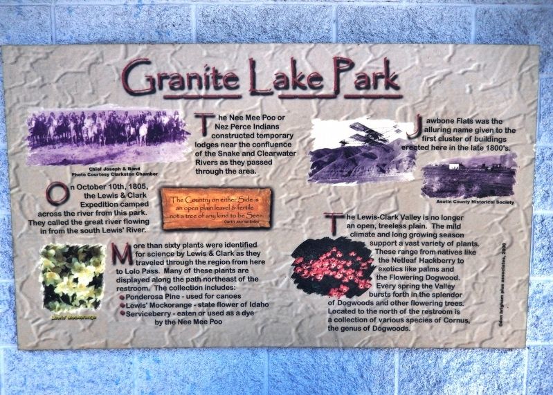
On October 10th, 1805, the Lewis & Clark Expedition camped across the river from this park. They called the great river flowing in from the south Lewis' River.
”The Country on either Side is an open plain leavel & Fertile …not a tree of . . . — — Map (db m129075) HM
While trekking westwards, the Lewis & Clark Expedition constructed dug-out canoes near the present-day city of Orofino. The Nee Mee Poo or Nez Perce Indians had shown the explorers how to burn out the centers of the Ponderosa pine logs. After . . . — — Map (db m129063) HM
"Swifter than any horse could run"
In fall 1805, the Lewis and Clark Expedition raced against time, hoping to reach the Pacific Ocean before winter set in. Traveling faster than at any other time during the journey, the party . . . — — Map (db m159272) HM
In the 1880's and 90's miners ventured up-lake searching for gold, silver, copper, and other metals. Wealth eluded them, but the scenic beauty of Lake Chelan and the Stehekin Valley made a fasting impression on all who passed through.
By 1900 . . . — — Map (db m196820) HM
Bordered by the Strait of Juan de Fuca and the Pacific Ocean, pre-contact Makah held a vast area of inland and coastal territory. These richly forested lands and the seas which teemed with life offered early Makah a wealth of natural resources. The . . . — — Map (db m129586) HM
According to a seventeenth century account, Apostolos Valerianos discovered a waterway through the northwest corner of North America in 1592 — a Northwest Passage. He reputedly sailed for the Spanish under the name “Juan de Fuca.”
For a . . . — — Map (db m177413) HM
Lighthouse tender boats supplied the Station by traversing Dungeness Bay from the mainland. At least four docks were built over the years. They were often destroyed by storms.
The original dock was constructed circa 1857. It is unknown if . . . — — Map (db m129695) HM
Approximately 10,000 years ago
Dungeness Spit began to form. The Spit is formed from sand and gravel from the Olympic Mountains carried by the Dungeness River into Dungeness Bay.
Debris is also sloughed off the bluffs to the . . . — — Map (db m129716) HM
Before 1846 American immigrants traveling the Oregon Trail to Fort Vancouver had to make a choice at The Dalles (80 miles upriver from here). They could navigate their own handmade raft or take a Hudson's Bay Company boat down the Columbia River to . . . — — Map (db m12295) HM
Look around you. The scenic spot where you now stand was once the heart of one of the busiest shipping ports west of the Rocky Mountains. From 1825 to 1846, Fort Vancouver's waterfront served as the western economic artery of the Hudson's Bay . . . — — Map (db m12293) HM
[Panel 1]:Captain George Vancouver Monument
October 31, 1792
Lt. William Broughton
Named This Area
For His Captain
Dedicated
October 31, 1992
[Panel 2]:Boat of Discovery
“…The real story of George . . . — — Map (db m8516) HM
[Panel 1]:
Capt. George Vancouver, from King’s Lynn, England, at age 35 and with orders from the British Admiralty to explore and chart the West Coast of America, charted hundreds of miles of coast line from California to Alaska. His maps . . . — — Map (db m8515) HM
In October 1832, the Japanese cargo ship Hojun Maru set sail from near Nagoya bound for Edo (present day Tokyo). Disabled in a storm off Enshu Nada, the Hojun Maru drifted for fourteen months before running aground on the coast near Cape Flattery, . . . — — Map (db m8423) HM
This anchor was dredged from the Columbia River in 1960 near Fort Vancouver’s wharf, one-quarter mile east of the Interstate 5 bridge. The anchor gives some answers about its history, but poses many more questions.
It is a Rogers Paten Small-Palm . . . — — Map (db m8691) HM
Grand Coulee Dam is the key structure in water utilization for the Columbia River Basin. The dam began operation in 1942 and is one of the world’s largest concrete structures. It is a mile long and contains almost 12 million cubic yards of concrete . . . — — Map (db m99853) HM
Begun in time of adversity it stood in war as a sentinel of strength safeguarding the nation. Forever a monument to those who shared in its conception and its construction in peace it is the key to new American frontiers of opportunity in . . . — — Map (db m129615) HM
Until recent times the Wanapum Indians inhabited the banks of the Columbia River from Beverly Gap to where it is joined by the Snake River near Pasco about 75 miles south.
The Wanapums were a very religious and peaceful people living on fish, . . . — — Map (db m92610) HM
We extend you a warm and friendly welcome to Coupeville in the heart of Ebey's Landing National Historical Reserve!
In 1792, Captain George Vancouver sailed the HMS Discovery into Puget Sound. His first mate, Joseph Whidbey then . . . — — Map (db m179345) HM
Humans have been part of this landscape for at least 10,000 years. By the time European explorers entered the Salish Sea in the late 1700s, the Lower Skagit people had [utilized] Whidbey Island for millenia, living in mobile and established . . . — — Map (db m179286) HM
Places to visit
1 Island County Museum
908 NW Alexander Street
The Island County Museum features local and regional history. Ice Age relics, woolly mammoth remains, a Native American collection that includes . . . — — Map (db m179321) HM
Penn Cove and Coupeville are home to the Schooner SUVA, during sailing season. See her moored at the historic wharf.
A FAMILY YACHT
In 1925, Frank J. Pratt Jr. had SUVA built in Hong Kong. Her old growth Burmese Teak hull and . . . — — Map (db m179319) HM
From the end of the Lake Ozette Road, 2 trails lead to the ocean beaches. One, the Indian Village Trail, leads to the site of an abandoned Ozette Indian village at Cape Alava. For over 2000 years, Cape Alava was home to the Makah Indians. . . . — — Map (db m179353) HM
Ferryboats have been active on Puget Sound since January 1, 1889. The City of Seattle offered the first scheduled service between Seattle and West Seattle; a bargain at 5 cents per passenger!
The Washington State Ferry System traces . . . — — Map (db m179348) HM
The Coupeville Wharf was built in 1905 in response to the increased economic, military and social activities in the area, and was one of several that supported the busy shipping commerce to and from Whidbey Island.
In the late 1800s, sailing . . . — — Map (db m179287) HM
The swirling waters that pass in and out of the narrow channels between Whidbey Island and Fidalgo Island have captivated visitors to this area for thousands of years. Salish Native American tribes were the first human inhabitants of these . . . — — Map (db m74012) HM
It's hard to imagine Deception Pass without the bridge. But until 1935, the gap between Fidalgo Island and Whidbey Island could only be crossed by boat. In 1924 a small ferry called the Deception Pass began running between Yokeko Point . . . — — Map (db m74083) HM
When the federal government transferred 1,700 acres of land on Fidalgo Island and Whidbey Island to the State of Washington in 1925, Deception Pass State Park was barely an idea. For decades, the land had been a military reservation set aside . . . — — Map (db m74085) HM
Named by Captain George Vancouver 10 June 1792. Feeling that he had been “Deceived” as to the nature of the inner waterway, Port Gardner (now Saratoga Passage) he wrote on his chart “Deception Pass”. He . . . — — Map (db m60904) HM
This Navy flagstaff is placed here to honor all those Navy people who have served aboard the Naval Air Station on Whidbey Island, their families, and the people of Oak Harbor who have long supported the Navy mission.
Our National Ensign was . . . — — Map (db m73990) HM WM
'Why do we love the sea? Because she has the power to make us think things we like to think.'
- Robert Henry
The Old Wharf and Steamships
Look offshore toward Maylor's Point and you will see a concrete block that remains from Oak . . . — — Map (db m73991) HM
The tribal name for the Hoh River is Chalak'At'sit (meaning "The Southern River"). The river itself is focal in Hoh tribal identity and folk-history and in traditional economic patterns. The Hoh people were created along the river. Mythic narratives . . . — — Map (db m129587) HM
Early settlers to the Port Townsend area found a S'Klallam Indian community well established on the protected shores of Port Townsend Bay. This settlement, known as Kah Tai, meaning "to carry" or "pass through," was located on the portage route . . . — — Map (db m179612) HM
The S'Klallam people made their canoes from Western Red Cedar trees ranging from 300-800 years of age. Seats and brackets were made of Yew wood, and paddles carved from Yellow Cedar.
Canoes Came In All Sizes
A freight canoe of good . . . — — Map (db m179378) HM
In 1989, the Canoe Culture was revitalized with the inception of the Intertribal Canoe Journey. The S'Klallam/Klallam Tribes participate in the Intertribal Canoe Journeys in which Canoe Families from dozens of Tribes travel to one destination . . . — — Map (db m179387) HM
For centuries, the S'Kallam people traded with other Tribes within the continental U.S. and across the Strait in Canada. Direct trade was the Native method of food and materials redistribution across geographical bounds, and from great . . . — — Map (db m179381) HM
The Jamestown S'Klallam Tribe, like the Northwest Maritime Center, is a 21st century organization with a tremendous appreciation of our seafaring history and respect for those who have preserved and shared their knowledge throughout the . . . — — Map (db m179410) HM
For over 8,000 years Native Americans camped at Point Hudson while migrating from summer camps to winter lodges.
The American explorer, Captain Charles Wilkes, named the area in honor of Commander William L. Hudson in 1841. . . . — — Map (db m179370) HM
Activated on 15 Dec. 1879, the original light was located atop the lightkeepers house. It was moved to its present position when this structure was built in 1913. The lighthouse has been closed to the public since its automation in Nov. 1976. . . . — — Map (db m197213) HM
Under the provisions of the National Historic Preservation Act of October 15, 1966, this property possesses exceptional value in commemorating, or illustrating American history Placed on the National Register on Sept. 29, 1970 — — Map (db m222603) HM
Port Townsend's strategic location at the entrance to Puget Sound won it the U.S. Customs Service headquarters in 1854, just three years after the town was established.
Every vessel entering Puget Sound from any foreign port was . . . — — Map (db m179374) HM
For thousands of years, the S'Klallam ("strong") people lived in villages along the north coast of the Olympic Peninsula, moving with the seasonal resources and living in harmony with nature. In addition to hunting in the mountains and . . . — — Map (db m179376) HM
Steven C. Brown, in his essay "Vessels of Life: Northwest Coast Dugouts," from The Canoe: A Living Tradition, by John Jennings published in 2002 by Firefly Books wrote: "The Coast Salish canoe incorporates features that make for a successful and . . . — — Map (db m179379) HM
Fin Fish included salmon, halibut, smelt and euchalon (a kind of smelt). Fish were taken with reef nets, dip nets, trawl nets, harpoons, gaff hooks, spears, basket traps, weirs, tidal pounds (rows of underwater stakes), hooks, and herring rakes . . . — — Map (db m179383) HM
☆
☆ Marvin G. Shields ☆
Construction Mechanic Third Class
☆United States Navy ☆
"For conspicuous gallantry and intrepidity at the
risk of his life above and beyond the call of duty
while serving with . . . — — Map (db m179363) HM WM
Why was Union Wharf so important?
Port Townsend's shores boast shallow waters, frequently less than 10 feet deep, dozens of feet out into the bay. As shipping became central to the boomtown's economy, this asset to early settlers . . . — — Map (db m179597) HM
Looking south, view Kilisut Harbor and Indian Island, now Naval Magazine Indian Island. Archeological evidence shows that Indian Island was an important location to the ancestors of the S’Klallam and Chimacum people for over 1,500 years. For . . . — — Map (db m179600) HM
On May 2, 1792. the intrepid English explorer, Captain George Vancouver, in search of a northwest passage, sailed his sloop Discovery and the armed tender Chatham down the strait of Juan de Fuca and into this sheltered harbor. This bay Vancouver . . . — — Map (db m177417) HM
Purser, mate, trader, Shipowner, venturer, Joshua Green began his waterfront career on Puget Sound in 1888 when steamboating was in its infancy. He founded the LA Conner Trading and Transportation Company, operating freight and passenger steamers, . . . — — Map (db m118081) HM
When dedicated on July 4, 1917, the Hiram M. Chittenden Locks was the largest navigation facility in North America. During the dedication, the USS Roosevelt - flagship for Commodore Robert Peary's famous 1909 expedition to the North Pole - led a . . . — — Map (db m86455) HM
The famous “Ton of Gold” that started the Alaska Gold Rush was unloaded here in 1897. The SS Portland landed the valuable cargo at this pier then known as Scwabacher Dock.
Ereceted National Maritime Day 1957 — — Map (db m47998) HM
At this site on August 31, 1896, the Nippon Yusen Kaisha Steamer ‘Miike Maru’ arrived with her cargo of tea. This was the first regularly scheduled steamer service between the Orient and Seattle and marked the birth of Seattle as an international . . . — — Map (db m47996) HM
The U.S. Navy’s “Great White Fleet” arrived Seattle May 23 and departed May 27, 1908 to continue their famous 46,000 mile round the world cruise. Part of the fleet anchored in Elliot Bay near this site and the crews disembarked here at . . . — — Map (db m48001) HM
In this area once part of the bay, vessels from ports all over the world dumped their ballast. Untold thousands of tons were unloaded into the water by ship’s crews including 40,000 tons from San Francisco’s Telegraph Hill.
The island, long a . . . — — Map (db m48122) HM
The site of the Indian camping place called Muck-Muck-Wum. In 1911 the headquarters of Washington’s first public port was established here by commissioners H.M. Chittenden, C.E. Remsberg and Robert Bridges. This tablet dedicated May 19, during . . . — — Map (db m48002) HM
Colman Dock was built on this site by
J. M. Colman in 1909. This dock was center
of ferry boat activity on Puget Sound.
Seattle Ferry Terminal dedicated May 18, 1966,
National Maritime Day - 1966 — — Map (db m112965) HM
[Front]
This commemorates the services of an energetic and wise leader in many enterprises undertaken for the general welfare especially the project for connecting Lake Washington with tide water by a ship canal
[Right side] . . . — — Map (db m47940) HM
A coal wharf was located at the waterfront during the late 19th century. Coal was transported here by railroad from Newcastle and Renton. Abandoned in the early 1900’s, the wharf soon became the Skinner & Eddy Shipyard.
During World War I, the . . . — — Map (db m48123) HM
Seattle’s first pier lies buried beneath your feet. The famous Yesler sawmill and wharf, constructed in 1853m marked the birth of Seattle’s great lumber and shipping industries. For many years it was the center of Seattle’s business district. . . . — — Map (db m48117) HM
Beneath your feet lies the wreckage of the pioneer sidewheel steamer "Idaho", which served from 1900 until 1909 as Dr. Alexander de Soto's famous wayside mission hospital. Here Dr. de Soto ministered to the needs of seafarers and the destitute, . . . — — Map (db m112964) HM
The Seattle waterfront played and exciting role in the early days of pioneer Seattle. Where you are now standing once was tidal flats, edged by forests. Salish natives traveled up and down the coast in intricately carved cedar dugout canoes and . . . — — Map (db m48003) HM
Welcome to downtown Seattle's neighborhood market. Pike Place Market is the city's center for fresh, local produce, specialty food and small independent businesses. Established in 1907 to connect citizens and farmers, the Market continues its . . . — — Map (db m235024) HM
Where did this bridge used to go?
In the early 1900s, trestle bridges connected many of Seattle's piers
on the central waterfront with the top of the bluff, offering an easy
way to negotiate the steep hillside between the two. In the . . . — — Map (db m235014) HM
Normally a pier, or dock, extends straight out from the shoreline. So why are the piers in Seattle angled? How would you build them?
Piers are constructed by first driving numerous pilings into the bottom of the bay to support the pier deck. . . . — — Map (db m99666) HM
History
The dinosaurs standing before you did not start their life here in Fremont on the shores of the ship canal. Built in the 1980's for an exhibit at Seattle's Pacific Science Center, the dinosaurs topiaries were about to be destroyed . . . — — Map (db m235250) HM
Medal of Honor Recipient Emil Fredreksen 1/5/1867-6/24/1950. Emil Fredreksen was the recipient of extremely rare peacetime Medal of Honor for his extraordinary heroism during the boiler explosion on July 21, 1905 aboard the USS Bennington . . . — — Map (db m109290) HM
Flat-bottomed boats carried passengers and goods on the Duwamish River to and from the Green and Black rivers from 1854 to 1886. Names of the boats were the Minehaha, the Black Diamond, the Decatur, the Comet, and the Gem. A landing for the . . . — — Map (db m181561) HM
Following the fire of 1914, one of the first buildings rebuilt in cement was
Young's Block, opening in 1915. Here the Olympic Restaurant reopened for
business, and Ronald Young opened a garage and auto livery service which
replaced the hotel's . . . — — Map (db m227841) HM
"determined to attempt the Chanel"
If you stood here before the river was flooded by the Dalles Dam, you would be looking at the upper end of the Long Narrows. That farro stretch of the Columbia River posed a formidable challenge to the . . . — — Map (db m158323) HM
Three Views of the River
When the Lewis and Clark expedition passed through the Short and Long Narrows of the Columbia in the early 1800s, the river looked dramatically different than it does today. The water was squeezed into narrow . . . — — Map (db m158633) HM
The Columbia River Gorge is a natural passage-way between rural inland farms and western shipping docks.
Transporting crops was difficult for early homesteaders who relied on wagons and steamboats. Water still provides a route, but modern barges, . . . — — Map (db m158631) HM
American Indians have harvested salmon from the Columbia River for over 10,000 years. Celilo Falls, a sacred location, now lies beneath the waters of the Columbia, directly east of the railroad bridge you see below. The loss of this fishery at . . . — — Map (db m128967) HM
The Lewis and Clark Expedition reached Celilo Falls, its first major obstacle on the Columbia River, on October 22,1805. William Clark named this imposing stretch of the river “Great Falls of the Columbia.” For millenia, tribes . . . — — Map (db m128969) HM
It used to be that you could throw a stick near the headwaters of the Cowlitz River beyond Packwood and it would float past here, to the Columbia River, eventually ending in the Pacific Ocean. Native Americans and pioneers alike not only used the . . . — — Map (db m158980) HM
Scotch Creek Basin, bordered by Schalow Mt. on the west and by Dunn Mt. and the Lime belt on the east, provided an ancient Indian trail to the Sinlahekin valley and north to Canada. Contorted sediments in the landmark Barnett Bluff are evidence . . . — — Map (db m223520) HM
When completed in 1941, Grand Coulee Dam was the world's largest concrete structure. It still is today.
President Franklin D. Roosevelt supported this massive federal project to dam the Columbia River because it put people to work during the . . . — — Map (db m196825) HM
In 1886, shortly after their arrival, Lee Ives and his wife Rena built two log cabins near the river bank and started taking in travelers. Their cabins were located very near this spot in what was to become Pateros.
Lee Ives built the Ive's . . . — — Map (db m129012) HM
Below this sign you can see the remnants of the China Ditch built by Chinese miners sometime between 1860 and 1880. This ditch carried water from a diversion point three miles up the Methow River to sluice gold from the Columbia River sandbars a . . . — — Map (db m128997) HM
In 1965, the entire downtown area of Pateros was destroyed when Wells Dam, located six miles downstream, was being constructed on the Columbia River. The entire downtown business district of Pateros was leveled. Paralleling the Columbia River, . . . — — Map (db m129014) HM
The head of navigation on the Okanogan River during steamboat days until 1914 when the railroad came. The shrill sound of the boat whistle to open the drawbridge, rattle of freight wagons and ringing of freight bells which served the north half of . . . — — Map (db m207934) HM
A Collision of Cultures
First they came by sea and then by land - the Euro-American presence swelled through the region. The newcomers brought strange illnesses, like smallpox and malaria, and unwittingly spread plagues of death to the . . . — — Map (db m177402) HM
Here the Columbia River, the mightiest river flowing into the Pacific Ocean from the American continents, ends its journey. Native people have lived along the banks of this river and fished its waters for thousands of years.
Euro-American . . . — — Map (db m177312) HM
The Chinook commanded the mouth of the Columbia and lands up the coast to Willapa Bay in the north and down the coast to Tillamook head in the south going back centuries. They lived at the heart of a vast trade network, and served as middlemen, who . . . — — Map (db m177358) HM
The Search for the Northwest Passage
How did Euro-Americans lay claim to this place? For centuries, explorers sent by European nations with imperial ambitions sought the Northwest Passage — a navigable sea route connecting the Atlantic and . . . — — Map (db m177405) HM
This place — where river meets ocean – is one of many stories. The Chinook people lived here at Qiqayaqilxam, or Middle Village, for countless generations. Qiqayaqilxam is one of several villages that stretched from Cape Disappointment to Pillar . . . — — Map (db m177411) HM
The Chinook people have lived along the Pacific Coast for countless generations — in fact, the Chinook say their ancestors were here at the end of the last ice age, when the waters and forests were very different. The people of this place would have . . . — — Map (db m177409) HM
Sailing a ship into the narrow channel at the mouth of the Columbia River was always dangerous and often deadly. Sailing ships would frequently be forced to wait for days and sometimes weeks for the weather to be right to "cross the bar."
Even . . . — — Map (db m116577) HM
The lighthouse has watched over the entrance of the Columbia River since was first lit on October 15, 1856. It stands fifty-three feet tall, has a focal plane of 220 feet above the sea, and tapers from a diameter of fourteen feet four inches at . . . — — Map (db m116607) HM
The U.S. Army constructed Fort Canby, along with Fort Columbia and Fort Stevens, to defend the entrance to the Columbia River from enemy warships. U.S. Army troops manned the forts from the mid-19th century until the end of World War II.
The . . . — — Map (db m116597) HM
Working and Living on North Head
Lighthouse keepers maintained the North Head Lighthouse from 1898 until its automation in 1961. Keeping the light burning 365 days a year was arduous, repetitive work.
Keepers carried gallons of oil up . . . — — Map (db m116574) HM
You are looking at Box Canyon Dam, which is owned and operated by the Pend Oreille Public Utility District.
The project was built in 1955. There are four generators in the project that generate 60MW of electricity. This is enough electricity to . . . — — Map (db m197110) HM
Only a few high-powered steamboats were able to make it through the rocks and rapids of Box Canyon until the U.S. Army Corps of Engineers completed blasting and clearing rock to widen and deepen the channel. Before 1907, most passengers and freight . . . — — Map (db m197111) HM
"Memory Vessel" was commissioned by the City to honor the Scandinavian heritage of families that influenced early development at the head of the bay. The artwork references the bond between the Scandinavian cultures and the sea. The vessel . . . — — Map (db m179836) HM
This area at the mouth of Donkey Creek was once the village site of the S'Homamish Indians. Gig Harbor was then known as Tua'wILkel or Twa-wal-kut.
As part of the Puget Salish people of the Pacific Northwest, the S'Homamish spoke a form of . . . — — Map (db m179871) HM
Boat building was one of the first industries on Gig Harbor's waterfront, beginning with the launch of the Vine in 1890 at the Gig Harbor Mill. More than 140 wooden boats were constructed along the waterfront between 1912 and 1931 at three . . . — — Map (db m179922) HM
The settlement of Gig Harbor by white people actually began on the east side of the harbor. Samuel Jerisich arrived in Gig Harbor in 1867 and built a small cabin on the east side of the bay near the sandpit. Later, the Jerisich family moved to . . . — — Map (db m179983) HM
Puget Sound: Fast Facts
• The Puget Sound is the second largest estuary in the United States, after the Chesapeake Bay.
• A "sound" is an arm, inlet, or recessed portion of the sea.
• Advancing glaciers carved out the Puget Sound . . . — — Map (db m179931) HM
In 1867, Sam Jerisich, Peter Goldsmith, and John Farrague were fishing in Puget Sound when bad weather prompted them to seek shelter in Gig Harbor. They liked what they saw and decided to make it their home, becoming the first three white people . . . — — Map (db m179977) HM
Anchor Donated by
Marion N. Stancic
In Memory of a Fishing Family:
Nickolas Castelan, Sr. 1874-1921
John (Evo) Stancic 1891-1971
John B. Stancic 1905-1974
John S. Jerkovich, Sr. 1896-1974
George A. Plancich, Sr. 1898-1963 . . . — — Map (db m179982) HM
150 entries matched your criteria. The first 100 are listed above. The final 50 ⊳