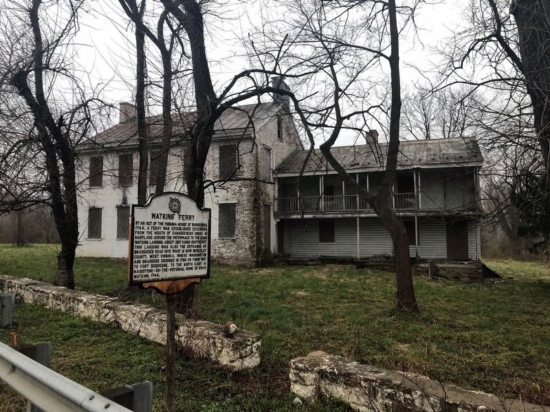
By an act of the Virginia House of Burgesses, 1744, a ferry was established extending from the mouth of the Canagochego Creek in Maryland across the Patowmack to the Evan Watkins Landing, about 250 yards southeast. This landing was also the entrance . . . — — Map (db m131795) HM
The Shaw Run Wetland Complex is a calcareous fen. A "fen" is defined as low land covered wholly or partly with water. fed by Shaw Spring and Shaw Run, the wetland is a unique type of wetland for West Virginia because of its marl substratum (layer . . . — — Map (db m150612) HM
County seat, incorporated in 1906 and
named for William Madison Peyton, a leader
in movement for the formation of Boone
County, 1847. Peyton, pioneer in the development of the Coal River Valley, locked and
dammed Coal River in the 1840’s and . . . — — Map (db m138449) HM
Named for William Madison Peyton,
father of navigation on Coal River,
who promoted and actively engaged in
coal mining. As chief engineer for the
Coal River Navigation Company, he
locked and dammed Coal River in the
1840’s and made it . . . — — Map (db m137511) HM
War comes to the Big Coal River. Emboldened by a resounding victory against Confederates at Boone Court House (Madison), Union General Cox ordered Federal troops back into the Coal River Valley. This time the target was the Big Coal River.
. . . — — Map (db m137753) HM
The Coal River is a tributary of the Kanawha River in southern West Virginia. It is formed near the community of Alum Creek by the confluence of the Big and Little Coal Rivers. The Coal River flows generally northward through western Kanawha County, . . . — — Map (db m137542) HM
George Washington began a journey on October 5, 1770 to the Ohio Country to see lands he had fought to win and now hoped to own. After a trip, on November 3, up the Kanawha River, the party headed back up the Ohio River. On November 17, they reached . . . — — Map (db m33913) HM
In the 1790's, flatboats left here with their cargoes for southern markets. To accommodate and store products, warehouses and wharfs were built along our river banks. This wharf, which was established in the 1800's, extended twenty feet out in the . . . — — Map (db m21637) HM
George Washington was made
president in 1785 of the
James River Company. His
plan of communication to
the West eventually resulted
in the construction of the
Midland Trail, U.S. 60, and the
Chesapeake and Ohio Railroad. — — Map (db m126041) HM
Mouth of the great Hawk's Nest Tunnel, three miles long, which diverts water of New River from its five-mile long gorge. The tunnel, a mile of which is through solid rock, and a 50-foot dam give waterfall of 160 feet for electric power. — — Map (db m34421) HM
In 1930 the Union Carbide and Carbon Corporation was in the process of building its new electrometallurgical plant in nearby Boncar (later known as Alloy). It was decided a hydroelectric power station would be constructed near Gauley Bridge with a . . . — — Map (db m173337) HM
You are in the New River watershed, a place where streams and rainfall drain to a common outlet. Here that outlet is the New River. This 320 mile river is the main stem of a 7,000 square mile watershed that starts in the western mountains of North . . . — — Map (db m179414) HM
The same geological process that produced the region's coal seams
also resulted in a layer of sandstone perfect for rock climbing
This layer, called Nuttall Sandstone, has its origins in the ancient
formation of the Appalachian Mountains. As . . . — — Map (db m165212) HM
With the opening of the iconic New River Gorge Bridge on October 22, 1977, the challenge of getting
across the 876 foot deep gorge was solved. The bridge dramatically decreased travel time. A 45 minute
winding drive down and back up suddenly . . . — — Map (db m165211) HM
John Townsend bought a large tract of land here in 1841, an area that became Lansing, Ames Heights and Canyon Rim Park. Operated a ferry that provided commercial transport across the river at site of present bridge until the civil war. Grandson . . . — — Map (db m78288) HM
In the early 1900s, over 80 coal mines and towns lined this gorge and were connected by the Chesapeake & Ohio (C&O) Railway. Freight trains ran every 15 minutes and a dozen passenger trains ran daily during those busy times. The area's industrial . . . — — Map (db m243360) HM
Completed in 1977, New River Bridge is the world’s longest single-arch steel span bridge. At 876 feet above the river it is American’s 2nd-highest bridge.
Features to Notice Color. The steel used here, Cor-ten steel, rusts slightly on the . . . — — Map (db m99996) HM
What is so special here? Why did the United States Congress in 1978 add New River Gorge to America’s system of National Parks? Because at New River Gorge National River there is:
(Inscriptions under the images-left to right, top to bottom) *An . . . — — Map (db m99975) HM
Occupying an area of land in a bend on the west side of the New River, much of what became the New River coalfields was once known simply as "the Loop" to early-19th century Virginians on the frontier. Bound by the river, the area was fed by two . . . — — Map (db m228745) HM
Located in the New River basin and bisecting portions of Raleigh and Fayette counties, Dunloup Creek historically has been the subject of many efforts to establish crossings, whether for pedestrian, railroad, or automobile. Foot bridges, wooden . . . — — Map (db m228748) HM
Nuttallburg was built around this picturesque stream, called Short Creek. The creek played a major role in the life of residents. It provided water for residents, water for Nuttalburg industry, and it divided the community socially. . . . — — Map (db m242431) HM
New River Gorge National River is one of over 400 National Park areas that protect our natural and cultural treasures and tell our nation's stories. Whenever you pass by the National Park Service arrowhead symbol you have entered a special place . . . — — Map (db m242572) HM
As access to places outside the gorge improved, Thurmond's importance declined. Area coal mines also declined in productivity. The most significant changes, however, came by 1949 when the nation's railroad industry had switched from steam to . . . — — Map (db m165249) HM
New River Gorge National River offers beautiful scenery and much more. The park features the geology of one of the world's
oldest rivers and preserves the natural and cultural diversity of a land once exploited by industry. Today New River Gorge is . . . — — Map (db m165244) HM
Brief History:
Blue Sulphur Springs Pavilion was constructed ca. 1838 as a centerpiece of a health resort which rivaled the famous Greenbrier in terms of its comforts and refinement. Crisp, clear water bubbled up from the natural spring in . . . — — Map (db m159704) HM
Site of Blue Sulphur Springs Resort 1835-1858. Water from spring said to have healing powers. Known as early settler campground & Buffalo Lick. — — Map (db m159703) HM
The Springhouse - symbol of The Greenbrier since 1835 because it sits atop the White Sulphur Spring. "Taking the waters" - either by bathing or by drinking for medicinal purposes - was the foundation of this resort. Earliest recorded use of the . . . — — Map (db m75421) HM
Early European settlers in this Allegheny Mountain valley learned from Shawnee Indian hunters about this sulphur water spring. Health-seekers soon started arriving to bathe in the waters to relieve the aches of rheumatism. By the 1830's the resort . . . — — Map (db m75422) HM
Named by boat captains for many brick works shipping from area. John Gamble first mined clay in 1839; James Porter had first brick works in 1832. By 1844, five works produced 1.5 million bricks. Later, some 20 plants: including Captain John Porter, . . . — — Map (db m44118) HM
Named by boat captains for many brick works shipping from area. John Gamble first mined clay in 1830; James Porter had first brick works in 1832; five works in 1844 produced 1.5 million bricks. Later, over 20 plants, using local clay, gas and coal, . . . — — Map (db m44120) HM
Side A:Captain John Porter(August 7, 1838 - February 7, 1893) Early developer of New Cumberland, he operated line of steamboats and barges on Ohio River, Chelsea China Company and glass plants. Known as "brick king" he owned Sligo, . . . — — Map (db m44121) HM
The river flowing past New Cumberland contributed significantly to the political, economic and social development of the town. Early settlers to New Cumberland came by river and then depended on the river as means of receiving supplies and . . . — — Map (db m44133) HM
After a failed raid on New Creek on August 4, 1864, the Confederate cavalry of Gens. McCausland and Johnson made camp near Moorefield on the South Branch of the Potomac. Hoping to smash the Rebel raiders, Union Gen. Averell led his smaller force in . . . — — Map (db m153025) HM
If you had been standing here about mid-morning of August 7, 1864, you would have seen Confederate soldiers running for the hills on your right. Confederate Gen. John McCausland's cavalry brigade was camped in the fields in front of you on this . . . — — Map (db m238789) HM
Who made the first settlement on Lower Simpson Creek in April 1772. He obtained a patent on 400 acres of land and built his cabin near this site. Later in the same year he returned to the South Branch and married Sarah Allen. They reared a family of . . . — — Map (db m229645) HM
A. S. Hugill built 75' long by 14' wide multiple king-post truss bridge in 1881 for $1483 on land of John Lowe. Survived great flood of 1888 but was washed away from original site 1/2 miles upstream in 1899. — — Map (db m8541) HM
The United States Department of Agriculture was authorized by Congress in 1953 to carry out a program of flood prevention and erosion control for Salem Fork.
The project was seven (7) earth dams along with land treatment measures to control . . . — — Map (db m173890) HM
Ravenswood. These lands were surveyed, 1771, for George Washington by Colonel William Crawford, who later was taken captive by the Indians and burned at the stake. Washington camped here in 1770. Here is grave of Jesse Hughes, noted scout. . . . — — Map (db m39625) HM
As General John H. Morgan’s raid into
Indiana and Ohio came to a close,
he tried to cross the Ohio River
into WV. Reaching the Buffington
Island ford late on July 18, 1863,
he waited until the 19th to cross.
Union troops and gunboats . . . — — Map (db m143871) HM
"I will pledge myself that there is not a spot in the United States which combines more or greater requisites...."
George Washington May 5, 1798 Harpers Ferry's history and geography have influenced each other for . . . — — Map (db m12065) HM
The boat ramp in front of you was the site of two daring escapes in the Battle of Harpers Ferry. Under the cover of darkness, 1,400 Union cavalrymen fled on horseback down the ramp, crossing a pontoon bridge into Maryland on September 14, 1862. . . . — — Map (db m158288) HM
Situated in a gap of the Blue Ridge Mountains and at the confluence of the Shenandoah and Potomac Rivers, Harpers Ferry, from its beginning, functioned as a natural avenue of transportation.
The first mode of travel consisted of a primitive . . . — — Map (db m12058) HM
Bridges spanning the canal, like the one to your left, provided access from the island to the mainland for residents and factory workers. During floods, they were paths to safety. To delay departure could spell disaster, as in 1870, when swiftly . . . — — Map (db m18987) HM
Meriwether Lewis arrived March 16, 1803. Oversaw building of collapsible iron framed, skin-clad boat and acquired supplies, tomahawks, and rifles. Left for Pennsylvania on April 18; returned July 7 to gather materials and left next day for . . . — — Map (db m2149) HM
In 1806, workmen with hand tools widened and deepened this channel for cargo boats to bypass, or "skirt," the rapids in the Shenandoah River. Linked with many other skirting canals" en route to Washington, D.C., this passage became part of the . . . — — Map (db m18988) HM
Water from the canal flowed through underground tunnels, turning water wheels and powering armory machinery before it exited through tailraces. — — Map (db m143943) HM
Work on the railroad and canal progressed slowly at first, but by 1834 both companies had completed construction to a point opposite Harpers Ferry. The canal had won the race to this point and it continued up the Maryland side of the Potomac. . . . — — Map (db m12062) HM
As the railroad streaked westward from Harpers Ferry, the C&O Canal fell hopelessly behind in the race for Ohio. Burdened by a lack of building supplies and a scarcity of skilled labor, the canal encountered serious financial problems and did not . . . — — Map (db m12064) HM
Rail transportation in the United States began in Baltimore, Maryland on July 4, 1828, when Charles Carroll, the only living signer of the Declaration of Independence, laid the cornerstone of the Baltimore and Ohio Railroad.
On the same day . . . — — Map (db m12060) HM
Home of General Charles Lee, built on land bought in 1774. Lee, colonel in British army, resigned his commission and joined the colonists after Battle of Lexington. On this estate, the U.S. Government maintains a fish hatchery. — — Map (db m12069) HM
Three miles west, on Opequon Creek, lived General Adam Stephen, 1754–1772. Original tract, with hunting lodge, was bought in 1750. The present mansion was built by Adam Stephen Dandridge, his grandson, in 1805. — — Map (db m1746) HM
Inventor of the Steamboat who in October, A.D. 1783, on the Potomac River near the mouth of Sir John's Run made the first successful application of steam to the practical purpose of navigation and who on December 3rd, 1787, made a further . . . — — Map (db m1936) HM
To commemorate their organization February 22, 1916 and preserve the original name of the town and river crossing of colonial days — — Map (db m103698) HM
Shepherd College. Incorporated as Shepherd College, 1871. Chartered by act of the Legislature, Feb. 27, 1872, as the Shepherd College State Normal School. Name changed in 1931 to Shepherd State Teachers College and in 1943, to Shepherd . . . — — Map (db m143926) HM
James Rumsey, inventor of the steamboat, lived here, 1785 to 1788, and in 1787 demonstrated his boat on the Potomac at this point. Here was born Colonel James Strode Swearingen, who commanded the men who founded the City of Chicago in 1803. — — Map (db m60704) HM
Shepherdstown, the oldest town in what is now West Virginia was incorporated as Mecklenburg in 1762, but was renamed Shepherd's Town in 1798 in honor of its founder Thomas Shepherd. From the French and Indian War to the Civil War the town has been . . . — — Map (db m143927) HM
Named in honor of the inventor, James Rumsey, who made successful demonstrations of his steamboat on the Potomac River here on December 3 and 11, 1787.
Opened and dedicated on July 15, 1939. — — Map (db m2019) HM
An inspection of tobacco shall be…established on the lands of the said Abraham Shepherd to be called and known by the name of Mecklenburg warehouse.
– Act of the Virginia Assembly, passed November 29, 1788.
Such an admirable site for mills, tanneries, and other industries, was not to be found every day.... And so they began, with the industry of beavers, to erect their mills, dwellings, forges, tanneries, shops, schools and meeting houses; . . . — — Map (db m103738) HM
980-1000 A.D. Voyages of Leif Ericson, Eric the Red
1492-1504 A.D. Voyages of Columbus
1497-1498 A.D. Voyages of John Cabot
1535-1536 A.D. Voyages of Jacques Cartier — — Map (db m178826) HM
Founded by George Clendenin and named for his father. Established, 1794. Fort Lee, built 1788, stood on Kanawha River. “Mad Anne” Bailey, the border heroine, and Daniel Boone and Simon Kenton, noted scouts, once lived here. — — Map (db m126868) HM
Daniel Boone
1789 Lt. Col. Of Kanawha Militia
An Organizer of Kanawha County
1791 Delegate to Virginia Assembly
His Cabin was Across the River
from Cave in Cliff Above
He hunted Deer and Made Salt
From a Spring at the Water's Edge . . . — — Map (db m241653) HM
1807 Encountered in Salt Drilling, Kanawha County
1825 Gathered at forks of Hughes River
1860-1863 Oil boom, Little Kanawha River
1889 Mannington Field opened
1890 Polecat Well No. 4 - Sistersville, Tyler . . . — — Map (db m178839) HM
Kanawha Boulevard has gone by various names throughout history. The Boulevard was known as Front Street when "Charles Town" was chartered in 1794. Through the years, it has been called First Street, Water Street and Kanawha Street prior to being . . . — — Map (db m85208) HM
Kanawha Boulevard has gone by various names throughout history. The Boulevard was known as Front Street when "Charles Town" was chartered in 1794. Through the years, it has been called First Street, Water Street and Kanawha Street prior to being . . . — — Map (db m179318) HM
Priscilla Byers • Richard Byers • Helen Irene Givens • Sherry Lyn Givens • Charles Dexter Jones • Alice Marie Null • Harry Fletcher Null • Larry Wayne Null • Robert Allen Null • Elma Day Saddler • Marcie Ann Saddler • Franklin Delno Sayre • Nancy . . . — — Map (db m228952) HM
For over 10,000 years, people have been drawn to the Kanawha River Valley. Arcadia encampments, like this, existed along the Kanawha River in 8500 B.C. Many mounds, including this South Charleston Creel Mound, were probably built around 500 . . . — — Map (db m178771) HM
Mill ponds have been the subject of song and romance. Blaker's Mill Pond provides the water for operating Blaker's Mill. While the mill is operating, water is pumped from the West Fork (of the Monongahela) River at the rate of around 2000 gallons . . . — — Map (db m197722) HM
Long ago, when the Great Spirit created Valley Falls, he made a masterpiece, which no writer's pen nor artist's brush has been able to do justice. Here was the ideal site for the ancient campfire of the children of nature to supply their needs, . . . — — Map (db m206430) HM
Marion County
Formed, 1842, from Harrison and Monongalia. Named for hero of the Revolution, Gen. Francis Marion. County was home of Francis H. Pierpont, leader in formation of this State. The Monongahela River forms just above Fairmont.
. . . — — Map (db m71114) HM
Marshall County. Formed in 1835 from Ohio. Named for Chief Justice John Marshall. In Marshall County is Grave Creek Mound, first among remains left by the unknown race which lived in the Ohio Valley centuries before the white man came. . . . — — Map (db m57250) HM
Marshall County. Formed in 1835 from Ohio. Named for Chief Justice John Marshall. In Marshall County is Grave Creek Mound, first among remains left by the unknown race which lived in the Ohio Valley centuries before the white man . . . — — Map (db m189430) HM
General Zachary Taylor, on his way to Washington to be inaugurated as the 12th President of the U.S., found his steamer blocked by ice here. He left his boat and completed his trip over the National Pike. — — Map (db m54810) HM
This two-story, frame house was built around 1885 for J. H. and Margaret Stone. Mr. Stone was born and raised across the street in the "Mansion House". J. H. Stone was a ferryman who, along with his family operated ferries on both the Ohio and . . . — — Map (db m189708) HM
This was the home of G.P. Gardner. Mr. Gardner served during the Civil War as a member of the First West Virginia Artillery. He was the owner of a local dock and sawmill. Gardner held the offices of Road Supervisor, School Commissioner, County . . . — — Map (db m178672) HM
This home was built in 1897 for Dr. Gutherie in 1913 it became the home of J. W. C. Heslop and Family. Mr. Heslop was the owner of the Point Pleasant Machine Works. This machine shop specialized in steamboat repair and the manufacture of all types . . . — — Map (db m189716) HM
[The mural features 3 panels:]
The USS West Virginia SSBN - 736
American Legion
For God and Country
All gave some - Some gave all
U.S. Navy
U.S. Coast Guard
United States Marine Corps
U.S. Air Force
U.S. . . . — — Map (db m178660) WM
Born October 9, 1720, in County Donegal, Ireland. The second son of John and Margaret Lynn Lewis. He served in the early campaigns on the American frontier. Wounded at Fort Necessity in 1754. Commanded the Big Sandy Expedition in 1756. With Forbes . . . — — Map (db m20791) HM
The city of Point Pleasant is located at the confluence of the Ohio and Kanawha Rivers. It is one of the oldest cities along the river. The city was first named by George Washington in 1770. While surveying the area, he named the point of land . . . — — Map (db m178603) HM
Mitchell first established this building in the mercantile business with a specialty for supplies. There has been a business on this spot since that time. The Point Pleasant River Museum was established in 2003 with a focus on the history, the lore . . . — — Map (db m178636) HM
After a devastating fire on Sunday July 1, 2018 at 28 Main St., the City of Point Pleasant built a state of the art facility on these grounds, which was purchased by the Point Pleasant River Museum Board, to educate and explore the wonders of our . . . — — Map (db m239226) HM
Constructed in 1928, connected Point Pleasant and Kanauga, OH. Name credited to aluminum-colored paint used. First eye-bar suspension bridge of its type in the U.S. Rush hour collapse on 15 December 1967, resulted in 31 vehicles falling into the . . . — — Map (db m124202) HM
In August of 1925, while steaming
into the port of Cincinnati, the boat
Sallie Marmet hit and sunk on this
anchor. The anchor was then raised
by diver Tom McGuffin and brought
to Point Pleasant, where it was
placed against the park flagpole . . . — — Map (db m125418) HM
Believed to have been a Shawnee altar stone made by the Water Panther Clan, which was Cornstalk's Clan, this stone was found at nearby Leon, WV, at 10-Mile Creek. The spiral shape of the tail is believed to represent the whirlpools that were in the . . . — — Map (db m178630) HM
Two Armies, two objectives, one piece of ground... Kesternich
The Allied Army
While Berlin was the political heart of Germany, the Ruhr Industrial Valley — with its coal mines, blast furnaces, . . . — — Map (db m152803) HM
Camp of Major (later General) Andrew Lewis in 1756, with Virginia troops, led by Smith, Hogg, Preston, Pearis, Woodson, and others, on way to attack Indians in Ohio. The Tug River and other streams were named by expedition. — — Map (db m136659) HM
Can you imagine a bustling community here made up of hundreds of people, all with livelihoods centered around this old stone furnace? The Henry Clay Iron Furnace was the fiery heart fueling this small community, and reminds us of our historic . . . — — Map (db m109189) HM
Ice's Ferry was settled by Frederick Ice in 1767. His son Adam, born the same year, was the first white child born in Monongahela Valley. Andrew Ice in 1785 started the first authorized ferry in western Virginia. — — Map (db m73337) HM
Monongalia County. Formed, 1776, from District of West Augusta. All or parts of 21 other counties, including three in Pennsylvania, were carved from it. Named for the Monongahela River, bearing an Indian name, which means the "River of Caving . . . — — Map (db m167179) HM
184 entries matched your criteria. The first 100 are listed above. The final 84 ⊳