Near Ellsworth Avenue (Nova Scotia Route 28) at James Street, on the right when traveling east.
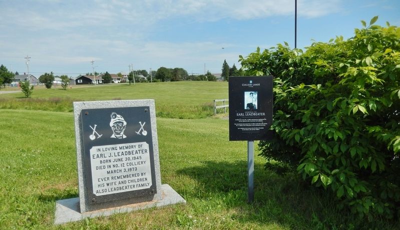
On March 3rd 1973, No. 12 Colliery experienced an underground fire. The fire claimed the life of coal miner Earl Leadbeater. This memorial has been placed here at Colliery Lands Park in his memory. No. 12 Colliery is his resting place as he is . . . — — Map (db m151726) HM
On Plummer Avenue east of Baker Avenue, on the right when traveling east.
Erected to the memory of those killed in explosion in No. 12 Colliery New Waterford July 25th 1917
Gaeton Angelo Aged 24
Yrs. • Frank Pancryk Aged 32
Yrs. • Constantino Boa Aged 22
Yrs. • Isaac Boone Aged 38
Yrs. • George Butt Aged 26 . . . — — Map (db m151635) HM
On Marconi Trail (Nova Scotia Route 255) 0.2 kilometers south of Birch Grove Road, on the right when traveling north.
The history of the village of Port Morien, rooted as it was in mining and fishing, is tightly entwined with Morien Bay itself.
The Mi'kmaq name was "Noolektooch", (Noo-lack-took) meaning "place jammed with ice", or "bivouacking place". Early . . . — — Map (db m144077) HM
[Face]
The Acadian village of Beaubassin on this site was founded by settlers from Port Royal around 1672. Upon the arrival of Major Charles Lawrence with British troops in April 1750, the French authorities had the village destroyed in . . . — — Map (db m106953) HM
This area was the site of the Acadian village of Beaubassin, first known Bourgeois settlement. Raided in 1696 and again in 1703 by a force from Boston under Captain Ben Church. Occupied by French troops in 1746 who travelled on snowshoes in . . . — — Map (db m106951) HM
Fort Lawrence
In the 18th century, the Chignecto Isthmus played an important role in the struggle between France and Britain for North American supremacy. In 1713 the Treaty of Utrecht had failed to clearly establish the border of Nova . . . — — Map (db m112110) HM
On Water Street just north of Victoria Street, on the right when traveling north.
Historically, the main streets were lined with hotels, merchants, and services one would expect of a long-standing port village. The village endured seven devastating fires between 1877 to 1929 that permanently changed the street-scape . . . — — Map (db m108083) HM
On Durham Street (National Route 6) 0.2 kilometers south of Irishtown Road, on the right when traveling south.
The Mary Crowley monument is the first public monument in honour of a Canadian-born female. It was erected in 1870 following a unanimous vote of the Nova Scotia Legislature. "Mary E. Crowley lies beneath this sod, a victim to fraternal love, having . . . — — Map (db m140763) HM
On July 13, 2006
a Canadian Forces helicopter
from 413 Transport
and Rescue Squadron
carrying seven crew members
who were exercising rescue
techniques with local
Canadian Coast Guard
auxiliary members
crashed in Canso Harbour. . . . — — Map (db m139669) HM
On Marine Drive (Nova Scotia Route 316) at Ballfield Loop on Marine Drive.
With the founding of Halifax in 1749 as a British naval base, the Acadians became the target of concern and possible displacement. Demands on them to accept and sign an "oath of allegiance” to the British crown were made several . . . — — Map (db m141258) HM
On Marine Drive (Nova Scotia Route 316) at Ballfield Loop, on the right when traveling west on Marine Drive.
The Deportation began in 1755 and ended with the signing of the Treaty of Paris in 1763. This Treaty not only ended what was perhaps the greatest human atrocity committed in British North America but it also gave Acadians the right to . . . — — Map (db m141389) HM
On Marine Drive (Nova Scotia Route 316) at Ballfield Loop, on the right when traveling west on Marine Drive.
Over the next eight years, or until the signing of the Treaty of Paris in 1763, the Great Upheaval continued in what has become known as the first act of "ethnic cleansing” in North America. In an ill-conceived and desperate plan . . . — — Map (db m141274) HM
On Windsor Street, on the right when traveling north.
Established in 1893, this non-denominational burial ground was originally known as the Green Lawn Cemetery. In 1894, the Fairview Lawn Cemetery Ltd. took over management of the cemetery which it operated for 50 years. Unable to fulfill its . . . — — Map (db m77857) HM
Near Union Street close to Kenny Street, on the left when traveling north.
This marker is composed exclusively pictures and their captions. There is a left side and a right side to the marker. Captions are presented left to right, then top to bottom. Click on the marker image to enlarge it. Left side
• . . . — — Map (db m77955) HM
On Windsor Street, on the right when traveling south.
English Here, in Halifax, lie the remains of 150 victims of one of history’s most tragic maritime disasters. Just before midnight on 14 April 1912, the White Star liner RMS Titanic struck an iceberg in the North Atlantic. The majestic . . . — — Map (db m77852) HM
To the memory of
the Unidentified Dead.
Victims of the Great Disaster
December 6, 1917.
—————————————
Here lie buried
Unidentified Victims
of the
Halifax . . . — — Map (db m113041) HM
On George Street at the Waterfront, in the median on George Street.
Just inland from this place, Chebucto Landing, 2,576 first permanent settlers of Halifax came ashore from thirteen small ships in June 1749. Here, you are at the shore of one of the great natural harbours of the world, the focus of Halifax's . . . — — Map (db m113185) HM
On Spring Garden Road just west of South Park Street, on the right when traveling west.
Hurricane Juan struck Halifax on September 29, 2003, devastating the Halifax Public Gardens. A volunteer-led foundation was formed to raise funds and restore the Gardens and historic Horticultural Hall.
This fountain and plaza were dedicated on . . . — — Map (db m112821) HM
On Duke Street just east of Argyle Street, on the left when traveling east.
The hands on the north clock face in the City Hall tower, opposite on Duke Street, are permanently fixed at 9:04:35 the exact moment of the wartime Halifax Explosion the morning of 6 December 1917.
The clock face, a replica of the City Hall . . . — — Map (db m139510) HM
This marker is composed of five plaques on the same mounting. The marker stands on north wall of the Citadel overlooking Halifax Harbor. The markers are presented left to right.
The Halifax Explosion / L’explosion d’Halifax . . . — — Map (db m78257) HM
The life story of Jeanne Dugas illustrates
the experiences of Acadíans in the second
half of the 18th century. She and her
family fled Ile Royale (Cape Breton Island)
to escape the deportation of 1758, but
were later captured by the . . . — — Map (db m139618) HM
L'église-souvenir
Un témoignage durable
L'église-souvenir représente l'attachement profond
du peuple acadien au lieu historique national du
Canada de Grand-Pré.
Construite en 1922 grâce à des fonds recueillis . . . — — Map (db m140428) HM
In 1755, the worldwide struggle for empire between Great Britain and France had tragic consequences for the Acadians of Les Mines and elsewhere in Nova Scotia/Acadie
Lt-Col. John Winslow was the Massachusetts officer in charge of the . . . — — Map (db m140393) HM
Le lit desséché du crique que l’on aperçoit dans le pré à quelques pas d’ici est l’endroit ou furent embarques sur les chaloupes les victimes du Grand Dérangement de 1755 pour être transbordes sur les transports ancres dans le Bassin des Mines. . . . — — Map (db m138777) HM
On King Street (Nova Scotia Route 3) at the Old Bridge Street bridge over the LaHave River (Nova Scotia Route 3), on the right when traveling north on King Street.
Up in Flames
In the cold, early hours of January 12, 1899, a fire began in the basement store of E. B. Simonson, located in the Music Hall at the corner of Dominion Street, and Commercial (now King) Street, where you are . . . — — Map (db m112426) HM
On Bluenose Drive close to King Street, on the right when traveling west.
English
Seafaring of all kinds, and fishing especially, is one of most dangerous occupations. Lunenburgers have lived with the dangers associated with making a living from the sea. Fishermen in dories would get lost in the fog, unable to . . . — — Map (db m78204) HM
Beginning in the early hours of November 1, 2001, fire ravaged this historic church, substantially destroying the building. Undaunted by the destruction, the parishioners decided to restore the church. With financial help from friends around the . . . — — Map (db m112454) HM
On Cornwallis Street at Cumberland Street, on the right when traveling north on Cornwallis Street.
This bell hung in the tower of St. John's since 1814 and served as the tolling bell for over 185 years. It was cast at the Whitechapel Foundry in London, England. On November 1, 2001, fire ravished through the Church, destroying the tower and . . . — — Map (db m112432) HM
On Main Street (Nova Scotia Route 3) just east of Legion Street, on the right when traveling east. Reported missing.
In memory of the crew of the
Beam Trawler Jutland
foundered at sea March 11, 1920
These crossed anchors recovered from
fishing banks on Jutland's previous trip
are placed as a symbol of our hope that
their souls are resting in . . . — — Map (db m112407) HM
Harbour of Deception
For almost two centuries, Yarmouth's False Harbour has lived up to its name. Located at the end of Cape Forchu, False Harbour's rocky shores have fooled the most experienced and capable of mariners, especially during . . . — — Map (db m107719) HM
The year 1879 was a disastrous one for Yarmouth County, Nova Scotia, with no fewer than 31 vessels lost along with 106 persons. The ships lost were among the best of the Yarmouth fleet, some carrying valuable cargoes. The loss of life left 26 . . . — — Map (db m107392) HM
Watching the waves crashing around Cape Forchu provides a small glimpse of the awesome and terrifying power of the sea. It continually shapes the lives of those who live and work by it. A source of beauty, bounty and economic prosperity, the . . . — — Map (db m107284) HM
There is not now and never has been a single definition of Acadie, or Acadia. It all depends on the time period and one's point of view.
Back in the 1600s and early 1700s, Acadie was a loosely defined region that more or less . . . — — Map (db m108271) HM
On the Lighthouse Route (Nova Scotia Route 3), on the right when traveling north.
The year 1879 was a disastrous one for Yarmouth County, Nova Scotia, with no fewer than 31 vessels lost along with 106 persons. The ships lost were among the best of the Yarmouth fleet, some carrying valuable cargoes. The loss of life left 26 . . . — — Map (db m112154) HM
On the Lighthouse Route (Nova Scotia Route 335) at Argyle Sound Road/Martell Lane, on the left when traveling south on the Lighthouse Route.
L'eau de la mer, des lacs et des rivières peut être source de bonheur, de plaisir, de richesses, mais l'eau peut être aussi source d'épreuves, de malheur.
Ce monument veut rappeler la mémoire de ceux et celles qui furent engloutis dans . . . — — Map (db m108397) HM
On Water Street at Glebe Street, on the right when traveling north on Water Street.
Dedicated to the memory of all those
residents of Yarmouth County
and crew members of ships owned
in Yarmouth County who have been
lost to the sea
We honour those here named as well
as those not yet known to us
[Remembered Dead . . . — — Map (db m107927) HM
On Water Street at Glebe Street, on the right when traveling north on Water Street.
The year 1879 was a disastrous one for Yarmouth County, Nova Scotia, with no fewer than 31 vessels lost along with 106 persons. The ships lost were among the best of the Yarmouth fleet, some carrying valuable cargoes. The loss of life left 26 . . . — — Map (db m107934) HM
On Water Street, on the right when traveling south.
Erected in 1911 at a cost of $1,200.00, the original Milton Clock was donated by Mrs. Robert Caie. The mechanical works of the clock were manufactured by J. Smith and Sons, Midland Clock Works, Derby, England. Located in the tower at the . . . — — Map (db m106141) HM
On Water Street, on the right when traveling north.
It is a long way from the farming community of Chegoggin, Yarmouth County, to a small village at the foot of Mount Ararat, but no journey was too far for Sarah Corning if there were children in need of care. Sarah Corning was born on 16 March, . . . — — Map (db m107902) HM