The 1st Kansas Colored Volunteer Infantry fought and won the Battle of Island Mound, also known as The Battle at Fort Toothman on October 28 & 29, 1862 in Charlotte Township approx. 7.5 miles southwest of Butler. It is said to have been the only . . . — — Map (db m54126) HM WM
Bates County was formed in 1841. Many early settlers came from Kentucky, Virginia and Tennessee. The 1860 census listed a population of 6,765 with a slave population of 442. In 1862, the slave population had dropped greatly.
Most Bates . . . — — Map (db m60614) HM
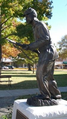
Here, on October 29, 1862 was the first crucible to test the mettle of formerly enslaved black men during the Civil War.
Here, a group of volunteers faced battle with the certainty of only two outcomes - victory or death - for there would be . . . — — Map (db m60581) HM
Most of the men of the First Kansas Colored Volunteer Infantry were escaped slaves. Many fled to Kansas from farms and towns in Missouri or Arkansas to find freedom. Some may have been "stolen" in Jayhawk raids. Others in the regiment were . . . — — Map (db m65049) HM
In the 1860s, the vast, rolling tallgrass prairies of the Osage Plains stretched for miles. Maintained by periodic fires for approximately 5,000 years before European settlement, prairie once covered approximately 78 percent of Bates County, Mo. . . . — — Map (db m60613) HM
During the fall of 1862, Bates County had become a haven for guerrillas and Confederate recruiters. One of their favorite haunts was a marshy tract on the Marais-des-Cygnes River, southwest of Butler, known to locals as "Hog Island." On Oct. . . . — — Map (db m65050) HM
African Americans saw the Civil War as a fight for their freedom. Early in the war, freed black men who tried to enlist in the Union Army were turned away. A 1792 Federal law still barred blacks from bearing arms for the U.S. Army. The U.S. . . . — — Map (db m60617) HM
After the 1854 Kansas-Nebraska Act was passed, pro-slavery Missourians and free-state Kansans fought over whether Kansas should enter the Union as a slave or free state. The fighting was so intense that the conflict was called "Bleeding . . . — — Map (db m60584) HM
The Sharp End was a thriving business district from 1910 - 1960. It disappeared through urban renewal and the use of eminent domain. John Lange Sr. and Annie Fisher were prominent business owners of a butcher shop and restaurant, . . . — — Map (db m169417) HM
From the 1930s through the 1960s, the two buildings located on the west side of 3rd Street between Pendleton & Switzler were a hub for family and commerce in Columbia's black community. A one-story, brick building housed the 3rd Street Market . . . — — Map (db m169472) HM
Alvan B. Coleman (1897-1968) owned Coleman Coal and Salvage, Tiger Theater, Tiger Lounge and other real estate. His father, James B. Coleman, was principal at Douglass School; his mother Julia taught there. Until Urban Renewal, the family home . . . — — Map (db m169469) HM
The Flat Branch has witnessed the accomplishments of Columbia's African-American community for generations. A free African-American, John Lange (later shortened to Lang), Sr., operated Columbia's first butcher shop in the public market from . . . — — Map (db m169422) HM
McKinney Building — Built in 1917 by Columbia black businessman Fred McKinney, the two-story building housed various businesses at street level. When completed, the building was heralded as "well finished" and praised for being among the first . . . — — Map (db m169431) HM
In the 1950s, businessman Alvan B. Coleman, with partners Edward and Ellis Tibbs, owned and operated the Tiger Theater at 109. N. Fifth Street. It was a theater for blacks by day and a nightclub at night. Their liquor store was in an adjacent . . . — — Map (db m169436) HM
Fifth Street Christian Church, founded as Second Christian Church, Disciples of Christ in 1861, is considered the first black church in the city. The first permanent church opened in 1879 at Seventh and Ash streets. With more than 200 . . . — — Map (db m169442) HM
Nora Stewart School opened in 1933 as the Negro Nursery School at 401 Park Ave. J.B. Coleman, an educator, owned the house and knew working parents needed a place for their children during the day. The school moved to the St. Paul AME Church and . . . — — Map (db m169444) HM
Gravesites for blacks were initially segregated in the south-central end of Columbia Cemetery near its intersection of Boone Road and Todd Drive. Blacks buried in this section include famed ragtime pianist and composer J.W. "Blind" Boone and . . . — — Map (db m169446) HM
Trubie's Market, 115 N. Garth, was owned by Trubie (Edwards) Smith from the early 1940s to the mid-1960s. it was one of few neighborhood markets serving blacks and one of the few women-owned businesses in the city then. "Ms. Trubie," who was . . . — — Map (db m169462) HM
Doby Flats—Stephen Doby, born on a S. Carolina plantation in 1854, came to Columbia about 1915. He built/owned Doby Flats (residential buildings) nearby and other houses. Wiggins Medical Clinic—Doby's daughter Ruth, a legendary teacher at . . . — — Map (db m169465) HM
Henry Kirklin (1858-1938) was a prize-winning internationally acclaimed horticulturalist. Born a slave in Columbia, he was freed at age 5. At age 14, he worked at Joseph B. Douglass' nursery, learning from European gardeners. Later, as a . . . — — Map (db m169474) HM
The African-American Heritage Trail commemorates Columbia's blacks, their enterprises and churches from the city's first 200 years. The Trail honors people who overcame enormous odds to achieve outstanding legacies, some receiving national and . . . — — Map (db m169420) HM
Annie Fisher (1867-1938) was heralded nationally for her business success. One of 11 children born in present-day Columbia to former slaves Robert and Charlotte Knowles, Annie worked as a child rocking cradles for white families. She learned to . . . — — Map (db m169473) HM
A city park in the black community was included in the official City of Columbia plans as early as 1935. For years, families had enjoyed outdoor summer activities at Douglass School, including baseball, softball, dances and picnics. Support for a . . . — — Map (db m169471) HM
Community leader, mentor, and educator for 56 years with the Columbia Public School District. During this time she developed and directed the Home School Communicator Program. This program, Mrs. Ralph's contribution to Columbia's Civil Rights . . . — — Map (db m169470) HM
Near this place James T. Scott, a Black janitor in the medical school at MU, was killed on April 29th, 1923. A mob brought Mr. Scott to the bridge, placed a noose around his neck, and pushed him over the railing while hundreds of spectators watched. . . . — — Map (db m169415) HM
From the early 1900s to the 1960, the Sharp End business district was a city within a city for Columbia's black community. Stretching from Fifth to Sixth streets on both sides of Walnut Street. Sharp End was a robust business center with . . . — — Map (db m169437) HM
During the early 20th century, the buildings at 4th and Broadway provided space where faith, music, and community converged. At 10 North 4th Street stands the home (c. 1890) of John William "Blind" Boone, a composer and concert pianist. His manager, . . . — — Map (db m169432) HM
Wynna Faye Tapp-Elbert was an extremely and well-respected citizen of Columbia. As a wholehearted member of various organizations, Wynna Faye worked tirelessly as a community activist to better the community for the youth, the African-American . . . — — Map (db m169466) HM
Tibbs Building — Built about 1940 at 17/19 Fifth St., the building housed Vess Bottling Co. Around 1960, Urban Renewal began displacing numerous black-owned businesses nearby. One of few to escape demolition, the building was purchased in 1962 . . . — — Map (db m169435) HM
Just south of Fort Smith hundreds of slaves escaped by crossing the frozen Missouri River during the winter of 1862-1863. Once in eastern Kansas, the slaves would move on to Iowa, Chicago, and other points north.
Slavery in Missouri generally . . . — — Map (db m79287) HM
Born in St. Joseph, Missouri, Coleman Hawkins got his first saxophone at age nine and was traveling coast to coast, recording with Mamie Smith and the Jazz Hounds while still in his teens. Credited with making the sax a solo jazz instrument, . . . — — Map (db m66410) HM
"The Columns" atop this hill are the venerated remains of Westminster College's original academic building, Westminster Hall, destroyed by fire in 1909. Founded in 1851, Westminster was one of the few Missouri colleges to function in some fashion . . . — — Map (db m70437) HM
[northwest side]Maj. Gen. John V. Cox Vice Adm. Arthur L. Willard [southwest side]Gen. Seth J. McKee Cpt. Stephen W. Thompson Gen. Roscoe Robinson Jr. [south side]PFC. Richard G. Wilson Congressional Medal of . . . — — Map (db m179990) HM WM
Josephine Baker (1906-1975) was born
in St. Louis, MO. Her creative, exotic acts
made her a singing star from New York
to Paris. During WWII, she worked with
the Red Cross, gathering intelligence
and entertaining troops in Africa and . . . — — Map (db m192145) HM
George Washington Carver (1864-1943) was born in Diamond Grove, MO. As an agricultural chemist and inventor at Tuskegee Institute, now Tuskegee University, in Alabama, he developed a system of crop rotation. He also discovered 300 uses for . . . — — Map (db m192155) HM
In 1911, Cape Girardeau members of the Missouri Chapter of the Woman's Relief Corps, an auxiliary to the Grand Army of the Republic, commissioned a memorial to the fallen soldiers of the City and County. Dedicated on May 30, 1911, the memorial . . . — — Map (db m236269) HM
The Civil War
Dred Scott (1795-1858) was born into slavery in Virginia and relocated with the family when it moved to St. Louis in 1830. In 1846, he sued to gain his freedom. After 11 years, in a landmark decision, he was denied his freedom . . . — — Map (db m192154) HM
has been placed on the
National Register
of Historic Places
by the United States
Department of the Interior
Not open to the public — — Map (db m99463) HM
[Front]
"Come, drink, all who thirst for freedom: The water fountain will no longer separate us as a people."
During the Civil War era, one of every four Clay County residents was of African descent. Although sold in slave auctions and . . . — — Map (db m68207) HM
The Clay County Fine Arts Council commissioned this mural in commemoration of the 200th anniversary of the Lewis and Clark Corps of Discovery expedition.
The artist's version shows the expedition stopping at sundown to set camp along a bend in . . . — — Map (db m68309) HM
Organized in 1875 by Rev. Jesse Mills. First church built in 1876. Present structure dedicated 1942 under pastorate Rev. A.G. Thurman, who also supervised construction. 104th anniversary celebrated 1979 under Rev. Jack Wills. — — Map (db m68240) HM
Meriwether Lewis • William Clark
York • Seaman • George Drouillard
———————
Sculptor: Sabra Tull Meyer
Columbia, Missouri
Project Designer: Austin Tao
St. Louis, Missouri . . . — — Map (db m62317) HM
During the next four decades, Lincoln University surpassed all expectations, growing into a culturally rich and diverse institution. In 1954, when the United States Supreme Court made Brown v. the Board of Education the law of the land, Lincoln . . . — — Map (db m169380) HM
Lincoln University was founded by the black enlisted men of the 62nd and 65th United States Colored Infantries and their white officers who fought for the cause of the Union during the Civil War. The black soldiers of these two regiments . . . — — Map (db m169375) HM
Dedicated to the
Officers and Soldiers
of the
62nd and 65th
United States
Colored Infantries
The construction of the
Soldiers' Memorial Plaza
was inspired by
the vision of
Dr. David B. Henson
17th President of . . . — — Map (db m62284) HM WM
Lincoln University was founded by the black enlisted men of the 62nd and 65th United States Colored Infantries and their white officers who fought for the cause of the Union during the Civil War. the black soldiers of these two regiments were the . . . — — Map (db m169386) HM
Towards the end of the war, the men began to solicit funds to accomplish this dream. With some donating as much as a year's salary to the cause, they were able to collect more than $6,000. Their efforts resulted in the establishment of a school that . . . — — Map (db m169376) HM
With the deeding of its property to the state in 1879, Lincoln Institute formally became a state institution. Later, under the Second Morrill Act of 1890, the school became a land-grant institution. In 1921, the Missouri Legislature passed a bill . . . — — Map (db m169379) HM
History
When Missouri became a state in 1821, the temporary seat of government was in St. Charles, Missouri. The Constitutional Convention was charged with the duty of selecting a permanent set of government and after much discussion and . . . — — Map (db m169360) HM
Born in slavery in St. Louis County, Mo.
Freed 1843
Founder, Elias Buckner African-American School in Boonville 1869 Established 32 Missouri schools for African-Americans in 1870
Secured state funding for Lincoln Institute (later Lincoln . . . — — Map (db m46016) HM
Built by Jesse and Polly Embry Harris four miles East of Jamesport between 1830 and 1836. They arrived with ten children and one slave. Reconstructed by the Harris family in 1985. The last Harris owners were Dr. George Dowe Harris, a Jamesport . . . — — Map (db m67337) HM
Originally a wood yard and steamboat stop along the Missouri River called Miller's Landing, the City of New Haven was first platted in 1856. Today, New Haven is home to over 2,000 residents, an award-winning school, artist community, and thriving . . . — — Map (db m132880) HM
Lynching in America
Thousands of Black people were the victims of racial terror lynching in the United States between 1865 and 1950. The lynching of African Americans during this era was a form of racial terrorism intended to intimidate Black . . . — — Map (db m240259) HM
A group supporting the Confederacy established this church under the leadership of Dr. Benjamin Burch. In 1883 it became the Crispus Attucks African-American School, later the Vocational Agriculture building for the Washington School District. — — Map (db m124406) HM
Built by the congregation of St. John's African Methodist Episcopal Church under the guidance of trustees William Hawkins, Peter Elkins, Emmett Jackson, Charles Taylor and others. This building served as their house of worship until 2004. In . . . — — Map (db m169276) HM
Born in Shelby, NC in 1940 to
Pink and Zannie Bell
Attended Cleveland High School
and the University of Minnesota
Father to Tracie, Bobby, Jr., and Joshua
Two-time All-American Linebacker/Defensive End
at the University of Minnesota . . . — — Map (db m72110) HM
Born in Carrabelle, FL in 1911 to
John Sr. and Luella O’Neil
Attended Edward Waters College
Married Ora Lee Owen in 1946
Played for the Kansas City Monarchs from 1938-1943
Managed for the Kansas City Monarchs from 1948-1955
Served . . . — — Map (db m72094) HM
Born in El Dorado, AR in 1939 to
Maud and Paralee Brock
From Age Two grew up in Collonston, LA
Attended Union High School and Southern University
Married to Jacqueline Gaitor
Father to Wanda, Lou, Jr., Emory and Daniel
Led Southern . . . — — Map (db m72157) HM
Born December 26, 1954, in Mobile, Alabama
to Clovis and Marvella (Pugh) Smith
Father to Osborne II, Dustin and Taryn
Played for the San Diego Padres from 1978-1981 and for the St. Louis Cardinals from 1982-1996
Fifteen Time National . . . — — Map (db m72212) HM
Lynching in America
Thousands of black people were the victims of lynching in the United States between 1877 and 1950. The lynching of African Americans during this era was a form of racial terrorism intended to intimidate black people and . . . — — Map (db m173592) HM
This church is the second home of Springfield's oldest African-American congregation. It was constructed in 1885 on a site 200 feet due south of here, between Brower Street and Chestnut Expressway. In 2000, Drury University purchased a new home for . . . — — Map (db m170812) HM
George Washington Carver was born into slavery in the early 1860's in Diamond, Missouri, in a one-room cabin. Soon after birth, he and his mother were kidnapped by bushwhackers. He was found in Arkansas but his mother was never seen again and . . . — — Map (db m236987) HM
This site overlooks the old "neck," the African-American neighborhood razed during Urban Renewal and replaced with McCoy Park. Many prominent families were served by residents of this community. — — Map (db m182930) HM
Hiram Young came to Missouri as an enslaved African American. He earned his freedom step by step. First he purchased his wife Matilda's freedom in the early 1840s. For children to be free, they had to be born to a free mother. The Youngs welcomed . . . — — Map (db m208243) HM
Alexander Campbell and Barton Stone, Disciple movement founders, preached to this congregation, founded July 4, 1835 with 35 members, 8 of whom were black. Alexander Procter was minister over 40 years. This neo-Roman church was designed by J.H. Felt . . . — — Map (db m140208) HM
Organized in 1861, the present building was erected in 1886. The congregation has been a spiritual, educational and cultural leader. The first black school was held here.
Western Baptist Seminary was organized in this church. — — Map (db m144550) HM
This imposing farm mansion was erected in 1855 for B.F. Thomson by his slaves. The Thomson family fled during the Civil War. In 1866 the farm was sold on the courthouse steps to Rev. J.D. Gossett. One of the finest Greek Revival mansions in Jackson . . . — — Map (db m233659) HM
The American Jazz Museum is an important cultural institution dedicated to its mission of celebrating and exhibiting jazz through performance, education, exhibitions and research at America's Jazz Crossroads - 18th and Vine.
There were four major . . . — — Map (db m98414) HM
The Negro Leagues Baseball Museum (NLBM), located in Kansas City's historic 18th & Vine Jazz District, is dedicated to preserve the rich history of professional African-American baseball of the early 1900s to the 1950s and its profound impact on . . . — — Map (db m98412) HM
The Garrison Field House, now Community Center, was designed by Benjamin Lubschez, an architect with Adriance Van Brunt and Company. When completed in 1914 for more than $55,000, the field house included an administrative office, gymnasium, . . . — — Map (db m242814) HM
The Artist
Ed Hogan, creator of the Exodus Family, is a life-long resident of Kansas City, Kansas. Hogan was born in 1937 and graduated with a degree in Fine Arts from the Kansas City Art Institute. He went on to get a master of Arts . . . — — Map (db m199278) HM
This Building was originally constructed as the Paseo YMCA which opened in 1914 to provide Kansas citians of color a place that would specifically allow them a public or private multi-purpose facility serving as a meeting place for community . . . — — Map (db m98433) HM
Richard Thomas Coles
(educator)
Located here at 1835 Tracy, the R.T. Coles Vocational and Junior High School opened in 1936 in the building formerly occupied by Lincoln School. The school was named for Richard Thomas Coles in . . . — — Map (db m200145) HM
The border between Missouri and Kansas was once the most contested dividing line in the nation. It was here that abolitionist jayhawkers from Kansas and pro-slavery troops from Missouri fought to preserve their ideals and ways of life. To many . . . — — Map (db m199291) HM
Born: April 26, 1947 Mobile, Alabama
Batted/Threw: Right
Position: Center fielder
Amos Otis played center field for the Kansas City Royals from 1970 to 1983. He was an All-Star in 1970, 1971, 1972, 1973 and 1976 and a gold glove award . . . — — Map (db m198919) HM
Born: June 17, 1940 Shelby, North Carolina
College: Minnesota
Position: Linebacker/Defensive End
Bobby Bell played for the Kansas City Chiefs in the American Football League from 1963-1969 and continued to play for the Chiefs in the . . . — — Map (db m198924) HM
Jackie Robinson was one of the greatest athletes of the 20th Century. Born in Cairo, Georgia in 1919. Robinson grew up in Pasadena, California, and was an outstanding high school and collegiate athlete in track & field, basketball, football, and . . . — — Map (db m198927) HM
Born: Nov. 13, 1911 Carrabelle, Florida
Died: Oct. 6, 2006 Kansas City, Missouri
Threw: Right
Position: First baseman, Outfielder, Manager
Buck O'Neil played for the Kansas City Monarchs in 1938-1947 winning the Negro American League . . . — — Map (db m198930) HM
Born: Feb. 18, 1949 Detroit, Michigan
Batted/Threw: Left
Position: First baseman
John Mayberry was a classic left handed slugging first baseman for the Kansas City Royals from 1972-1977. He took center stage his first season in Kansas . . . — — Map (db m198922) HM
Born: April 19, 1935 Chicago, Illinois
Died: April 6, 1998 Omaha, Nebraska
Batted/Threw: Right
Position: Relief pitcher
John Wyatt was 26 years old when he broke into the big leagues on September 8, 1961, after pitching in the Negro . . . — — Map (db m198931) HM
Timeline:
1923: Stadium opens as "Muehlebach Field", named for George Muehlebach, who owned the minor-league Blues
1924: KC Monarchs won the Negro Leagues World Series here
1937: Ballpark was named "Ruppert Stadium" honoring Yankees . . . — — Map (db m198933) HM
Born: July 7, 1906 Mobile, Alabama
Died: June 8, 1982 Kansas City, Missouri
Threw: Right
Position: Pitcher
Satchel Paige was known for his outstanding control as a pitcher and his love for the game of baseball which made him one of . . . — — Map (db m198929) HM
Known as:
• Muehlebach Field (1923-1937) • Ruppert Stadium (1937-1943)
• Blues Stadium (1943-1954) • Municipal Stadium (1955-1976)
(front side:)
You are standing on the former site of Municipal Stadium, originally named . . . — — Map (db m198918) HM
Has been designated a
National Historic Landmark
This site possesses national significance
In commemorating the history of the
United States of America
This hall used by Musicians Union Local #627 served as a center for the . . . — — Map (db m6706) HM
Born: August 11, 1942 Houston, Texas
College: Prairie View A&M University
Position: Wide Receiver
Was one of the best and most exciting wide receivers of his era…Played in one AFL All-Star game after the 1966 season and two AFC-NFC Pro . . . — — Map (db m198932) HM
News editor, 1923-1931, of The Kansas City Call. This plaque is dedicated in honor of his contributions to journalism and equality while he served as a journalist and, later, as leader of the National Association for the Advancement of Colored . . . — — Map (db m98427) HM
Born: Aug. 21, 1945 Clover, Virginia
College: Morgan State
Position: Linebacker
Willie Lanier played for the Kansas City Chiefs in the American Football League from 1967-1969 and in the National Football from 1970-1977. He was an AFL . . . — — Map (db m198925) HM
front left panel
Leroy Robert
(picture of Satchel)
July 7, 1906
June 8, 1982
front right panel
Lahoma Jean
(picture of Lahoma)
April 7, 1922
Sept. . . . — — Map (db m26607) HM
Originally known as Ottawa, 12th Street spanned from the West Bottoms, nestled in the confluence of the Kansas and Missouri rivers, to the eastern suburbs, dotted by small bungalows. At first a colorless retail strip, 12th Street blossomed into an . . . — — Map (db m200146) HM
Lynching in America
Thousands of Black people were the victims of racial terror lynching in the United States between 1877 and 1950. The lynching of African Americans during this era was a form of racial terrorism intended to intimidate Black . . . — — Map (db m198772) HM
Young (1812-1882) came to Missouri as a slave. He saved enough money to purchase both his freedom and his wife Matilda's freedom. By 1850, the Young family settled in Independence, where he became known for manufacturing high quality wagons for . . . — — Map (db m199428) HM
James P. Beckwourth (1798-1866) was born in Virginia in 1798 to a slave mother and a white father. His father brought James as a child to Missouri, and soon released him from slavery. Beckwourth, on the first of his several trips from Missouri to . . . — — Map (db m199380) HM
(This marker has two panels. From the left panel:)
Key Map
Traveling across this bridge, the fourth Red Bridge near this location since 1859, you may notice art panels attached to each of the large pillars that rise at both . . . — — Map (db m210568) HM
Public/private partnerships preserve three National Historic Trails in south Kansas City, highlighting 19th century exploration and migration that shaped the nation. In the heart of the historic 3-Trails Corridor, the Trailside Center at East 99th . . . — — Map (db m199522) HM