Architect; Carl Werner
Builder: Cochran Boehm, Inc.
Superintendent of Schools: W.G. Paden
Original Cost: 1,125,000
The historic Alameda High School was dedicated on 18 August 1925, and provided for the first time a modern high school . . . — — Map (db m79875) HM
Becoming a Japantown
A neighborhood planted, a community flourished
With the growth of Japantown, the Tonarigumi, or cohesive neighborhood, began to take shape as Japanese immigrants settled in dwellings, cottages and Victorian flats, . . . — — Map (db m223699) HM
In 1908 construction of the Albany School began on Main Street, now Solano Avenue. The building was demolished during 1946-1947 to make way for the current Cornell School buildings. — — Map (db m137107) HM
Miller’s Barn, owned by Chris Miller, was the first school in Ocean View, now known as Albany. Located near here, the barn was also the site of the town’s first civic meetings. Mr. Miller, one of three school trustees and the town’s first Marshall, . . . — — Map (db m137079) HM
This site has served the educational purposes
of the people of California since 1860 when
it became the home of the first public
institutions in Berkeley, the California
Schools for the Deaf and Blind. The Schools
moved to Fremont in 1980 and . . . — — Map (db m179262) HM
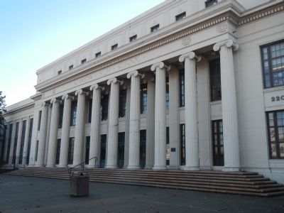
Gilman Hall was built in 1916-17 to accommodate an expanded College of Chemistry under the leadership of Gilbert Newton Lewis. This building provided research laboratories and teaching facilities for faculty and students specializing in physical, . . . — — Map (db m15870) HM
City of Berkeley Landmark
designated in 1995
The Glass House is considered one of the best residential works of Wurster, who was the founding dean of UC Berkeley’s College of Environmental Design. This simply detailed, shed roof house was built . . . — — Map (db m53858) HM
City of Berkeley Landmarks
designated in 1982
Berkeley architect and civic leader Walter H. Ratcliff, Jr. designed the Hillside School as one his last public commissions. The school takes its name from the Hillside Club, an early 20th-century . . . — — Map (db m53861) HM
City of Berkeley Landmark
designated in 1993
The residential subdivision of Thousand Oaks was incorporated into Berkeley in 1920. On this site, one year earlier, a new school building overlooking Blackberry Creek was built to replace wooden . . . — — Map (db m53847) HM
Bobby Seale
class of 1954, while attending Merrit
College, he joined the Afro-American
Association (AAA) and met Huey P.
Newton. Together in 1966, they founded
the Black Panther Party for Self-Defense.
Jean Yonemura Wing
class of . . . — — Map (db m154869) HM
From 1877 to 1988
the Sisters of the Presentation
of the Blessed Virgin Mary
operated Berkeley's first convent
and parochial school on this block.
The land was donated by
Berkeley pioneer James McGee.
The grounds included a garden and grotto . . . — — Map (db m137043) HM
City of Berkeley Landmark
designated in 1983
John Muir School was built beside Harwood Creek on land once part of a 19th-century country estate. The half-timbered style reflects the scale and architecture of the neighborhood and the nearby . . . — — Map (db m54682) HM
City of Berkeley Landmark
designated in 1994
“To Inculcate the Highest Standards and Ideals in Business.”
That lofty aim, incised high on the façade of this graceful Spanish Colonial building, guided Armstrong College for more . . . — — Map (db m54513) HM
1939-1940
City of Berkeley Landmark
designated in 1982
These buildings are fine examples of the Art Deco style in the Bay Area. They were designed as an ensemble with the adjacent Berkeley High School Community Theater. Bas-reliefs and . . . — — Map (db m54218) HM
James W. Plachek, Architect, 1930
Addition, Ripley/BOORA Architects, 1999
Listed on the National Register of Historic Places
Berkeley’s first free public library system was established in 1895, with branches in west and south Berkeley. The . . . — — Map (db m52364) HM
An apple orchard, two houses, and a tailor shop once occupied this block. In 1879, six local businessmen and a university professor financed the purchase of part of the block near Oxford Street as the site for one of the city’s first public schools. . . . — — Map (db m54336) HM
This compact complex of buildings linked by a series of arcades and academic quads in the English tradition was created to house one of Berkeley's oldest seminaries. Hobart Hall, designed by Julia Morgan, is notable for its elaborate brickwork, . . . — — Map (db m50801) HM
This park honors the memory of
Frances Elizabeth Willard
1839 - 1898
Feminist
Founder of the Women's Christian Temperance Union
Fighter for women's rights and free public education
First woman college president
First Dean of . . . — — Map (db m239025) HM
City of Berkeley Landmark
designated in 1984
This reinforced concrete Moderne-style building replaced an 1892 wood frame school. Faculty of the original school planted the five Coast Redwoods at the southwestern edge of the school grounds. The . . . — — Map (db m54192) HM
City of Berkeley Landmarks
designated in 1986
Allenoke is the only large estate remaining near the northern edge of the University of California campus. It was designed by Ernest Coxhead for Allen Freeman, President of the Bank of Oakland. . . . — — Map (db m53888) HM
City of Berkeley Landmarks
designated in 1986
When prominent educator Benjamin Ide Wheeler became president of the University of California in 1899, he and his wife built this spacious home. They entertained many dignitaries here, including . . . — — Map (db m53890) HM
Always go with nature, anywhere, in any circumstance, with gratitude.
The renowned and highly respected Japanese American artist Chiura Obata was a popular member of
the faculty at the University of California, Berkeley from 1932 to . . . — — Map (db m122842) HM
was a college football star at the
University of San Francisco and #1
NEL draft pick but lost the chancce to play
pro football when he suffered a career-
ending knee injury during a college all-
star game. Instead he became the
first African . . . — — Map (db m145994) HM
City of Berkeley Landmark
designated in 1993
Entomologist, naturalist, physicist, and inventor Charles W. Woodworth designed and built this all-redwood house in the Bay Region style. The three-level, seven-bedroom home has a brown shingle . . . — — Map (db m54877) HM
William C. Hays, Architect, 1922
James W. Plachek, Architect, 1930
John Reid, Jr., Architect, 1935
ELS/Elbasani & Logan Architects, 1998
As electric streetcar transportation improved and expanded in the early 20th-century, this section . . . — — Map (db m53873) HM
City of Berkeley Landmark
designated in 2005
The Berkeley Piano Club, dedicated to the performance and study of music, was founded in 1893 by a group of local women. Early meetings were held in members’ homes and later in a barn at the . . . — — Map (db m54726) HM
Originally located at Sixth and Delaware streets, this simple wooden building was constructed by volunteers from the Workingman’s Club, a west Berkeley political organization. Built as a reading room for laborers, it was used briefly as Berkeley’s . . . — — Map (db m53836) HM
These landmarks form the historic core of the first University of California campus, opened in 1873: Founders’ Rock, University House, Faculty Club and Glade, Hearst Greek Theatre, Hearst Memorial Mining Building, Doe Library, Sather Tower and . . . — — Map (db m229323) HM
This site was part of the original Don Castro Land Grant. In 1866 pioneer settler Josiah Grover Brickell made a land grant of this site for “educational purposes only” and paid the teacher’s salary, who taught children by day, in a one . . . — — Map (db m100557) HM
Marker One:
An open meeting place for a new generation, Antone Pavilion was built to pay tribute to the community’s roots, commemorating the school that once helped build dreams and change the lives of early settlers. After years of sending . . . — — Map (db m204572) HM
John & Katherine Donlon Flanagan from Longford, Ireland came to Dublin in 1868. In 1896 John was blinded, but continued to raise sheep and farm with the help of his wife and 3 girls, Eva, Katherine (Murphy), and Elizabeth (Nevin), who was a teacher . . . — — Map (db m201557) HM
A native of Germany, he married Bertha Koopman, native of Dublin. He farmed and operated a butcher business, delivering fresh meat from a horse-drawn wagon. He was an Amador High School Trustee for 17 years. — — Map (db m201570) HM
The Kolb Family settled in Dublin in the 1870’s. George Kolb operated the General Store and farmed. His sons, Edwin and Harold, also ranched and farmed. Harold (H.W. Kolb) was a trustee for the Murray School District for 17 years and was a noted . . . — — Map (db m201563) HM
Originally from Denmark, Peter Nielsen settled in Dublin in the late 1800’s leasing a large tract of land from Dougherty on what is now called the Camp Parks, Dougherty Valley area. His son, Tom, (1865-1956) purchased land in the Silvergate Dublin . . . — — Map (db m201561) HM
Approximately one mile west John M. Horner built the first American schoolhouse non-Catholic chapel in Centerville, Alameda County, 1850. Said to be the first Latter Day Saint Chapel in California. A small structure with three windows in the side . . . — — Map (db m26629) HM
On this site once stood the home of Barbara Bunshah (b. 1926 - d. 2007) City Librarian, curator of the Livermore History Center, and creator of the "Bunshah Index" of Livermore newspapers, and who resided here from C. 1958 to 2007. — — Map (db m199128) HM
Current site constructed 1923
Alameda County, California
For the purpose of providing
a continuation of essential
education and learning
Angelita Parlor No. 32, N.D.G.W, Livermore, California
Donner Parlor No. 193, N.D.G.W., Byron, . . . — — Map (db m92924) HM
University of California, chartered March 23, 1868. Located between Franklin and Harrison, 12th and 14th Streets, from 1869 to 1873, using buildings of former College of California, successor to Contra Costa Academy founded by Henry Durant, June . . . — — Map (db m100544) HM
Built by the citizens of Markleeville in 1882 it remained in operation until 1929 when the new Webster School was completed. In 1966, with the old school on the verge of total destruction, the Historical Society of Alpine County began to raise funds . . . — — Map (db m3006) HM
This building was designed by Frederic J. DeLongchamps, a designer and engineer of mining, born in Reno, Nevada, on June 2, 1882, and educated in Nevada. He designed 500 buildings, including schools, courthouses, commercial structures, and . . . — — Map (db m3089) HM
The first high school in Amador County was erected on this spot in 1903 by the Ione Academy, a private corporation. The original two-story frame structure, built at a cost of $2,287, housed the school until 1939. As a result of the steady growth in . . . — — Map (db m94743) HM
The “castle,” built in 1890–1894, is the most significant example of Romanesque Revival architecture in the Mother Lode. It was built to house the Preston School of Industry, established by the State Legislature as a progressive . . . — — Map (db m100594) HM
The Foothill Station became the first University of California qualifying outlying station funded jointly by federal, state and local county sources in March 1888. The station was developed under the patronage of Senator A. Caminetti of Jackson. . . . — — Map (db m72065) HM
The William J. Paugh House, also known as Rosewall, is a very pure example of a Gothic Revival House. The style was most popular during the 1840's and 1850's. It was built in the late 1850's by Charles L. Parish, artist, architect and builder. . . . — — Map (db m28067) HM
This bell called the children of Shenandoah Valley to school. The school district was first named Williams after the family with the most children, then changed to Shenandoah in 1916. In 1952 with the creation of the Oro Madre School District . . . — — Map (db m10350) HM
Dedicated to the early Shenandoah Valley pioneers & their descendants. They mined gold & produced grain, livestock, orchards & vineyards in these rolling hills. Nearby are the old school, used for 100 years, and now a social center, and the cemetery . . . — — Map (db m10639) HM
A man of tremendous ambition, Leland Stanford, Sr., was one of California’s most distinguished businessmen, politicians, philanthropists, and proponents of education. Lured to California by the Gold Rush in 1852, he became an owner of Sutter Creek’s . . . — — Map (db m12610) HM
Located 3.49 miles southwest of this location on Sutter Creek Volcano Road several hundred feet above the river. This quarry produced high quality marble used in the construction of Stanford University as well as many of San Francisco’s civic . . . — — Map (db m27809) HM
Erected in 1894 by C.H. Hintz this building was used continuously for school purposes until 1966 when due to unification, pupils were bussed into Chico. The first teacher was Miss Ada Woods. Cost of building was $600.Purchased by Centerville . . . — — Map (db m29692) HM
Completed in 1868, the home featured many surprisingly modern conveniences including running water, flush toilets, an acetylene gas lighting system, eight fireplaces, and wall-to-wall carpeting. The pink stucco mansion was designed by San Francisco . . . — — Map (db m29644) HM
The Oregon School District was formed in 1856 and the schoolhouse stood near Dry Creek behind the old Pence Hotel. In 1872 the schoolhouse was relocated and rebuilt behind the existing corrals south of present day Durhan-Pentz Road. Following the . . . — — Map (db m65869) HM
The one room school built here in 1863 survived mining booms and busts, world wars and a great depression only to have social changes close its doors forever in 1949. It is with sincere gratitude that we donate this marker for opportunities provided . . . — — Map (db m61705) HM
Oroville Carnegie Library, built 1912, has been placed on the National Register of Historic Places by the United States Department of the Interior.
In 1911, Andrew Carnegie, Scottish industrialist, businessman, and major philanthropist, . . . — — Map (db m17229) HM
This brick building, erected in 1858 with funds raised by a dance in the Billiard Saloon of the N.R. Prince Building (which still stands), is one of the oldest schools of California. Used as a school until 1950, it was then replaced by the present . . . — — Map (db m10143) HM
He was born Sept. 25, 1882 on the old Stevenot Homestead one-half mile west of this marker. Son of Emile K. and Sarah E. Stevenot and the grandson of Gabriel K. Stevenot, Calaveras County pioneer who pitched tent there in April, 1850.
Student, . . . — — Map (db m6847) HM
Fashioned as either small ornaments or large enough to be heard for miles, bells have long been a part of human history and culture. First appearing around 2000 B.C. as simple percussion instruments, they continue to celebrate special events to this . . . — — Map (db m101587) HM
Avery one-room school was established April 4, 1886. School was in session from March to December due to winter snows that kept the highway closed.
Hazel Fischer taught here from July 1916 to March 1941. Ms Fischer took all the students to San . . . — — Map (db m53304) HM
[Displayed at the Copperopolis Elementary School are a bell and a cannon along with their accompanying markers:]
The Bell
This bell cast in 1860, the first school in Copperopolis in 1862. The bell yoke shows repair, break . . . — — Map (db m19793) HM
Patented as a townsite in 1872, this early
town derived its name from a sawmill
located here. A post office established at
Mountain Ranch in 1856 was moved to
El Dorado in 1868 and El Dorado has thus
become known as Mountain Ranch. . . . — — Map (db m239835) HM
First American scientist awarded the Nobel Peace Prize (Physics – 1907); Dean of American Optics; Measured velocity of light, ether drift, standard meter, steller diameters. Lived here during childhood. — — Map (db m32818) HM
Built in 1860, second oldest building in California used continuously for school purposes. Cost four thousand dollars for two rooms as at present. Called "Pine Grove College" by pupils. J.A. Smith, Calaveras County Superior Court judge for 37 years, . . . — — Map (db m66110) HM
College City is the site of the Pierce Christian College established in 1874 through the generosity of Andrew Pierce, founder of both the town and the college. The college provided Christian education for the young people of the area until the . . . — — Map (db m41810) HM
Lower Marker
Colusa Union High School
Has been placed on the
National Register
of Historic Places
By the United States
Department of the Interior
Built 1926
Upper Marker:
Colusa
Union High School . . . — — Map (db m18139) HM
Original Site of the
Alamo Grammar School
The first school was constructed on this site in 1876 and was destroyed by fire. The second school was built in the 1880s and included a bell tower. The third was built in the 1940s and served as . . . — — Map (db m152685) HM
Used from about 1880 to 1940 in the second Alamo school building which stood at the east side of Danville Blvd. near Stone Valley Road. — — Map (db m154889) HM
Upon the closing of Riverview Union High School in the fall of 1931, Live Oak (later to become Antioch Unified) School District opened a new high school on D Street. This cupola, which at the time had a Mayflower weathervane atop, was placed . . . — — Map (db m93603) HM
This was the first high school constructed in Contra Costa County. Supported by the Womans Club of Antioch, the first joint communities bond was passed in 1908 for $20,000 by Antioch, Pittsburg, Somersville, Nortonville and Live Oak.
Charles . . . — — Map (db m91845) HM
The first schoolhouse in the area was built south of Danville in 1858. In 1867, a new grammar school was built on this Front Street site. This building served until being razed in 1896 and replaced by the one-room schoolhouse pictured. It was . . . — — Map (db m200170) HM
This Queen Anne style cottage matched
several other cottages which were once located
along the east side of Hartz Avenue. Harvey R.
Eddy bought this property in 1903 and deeded
the home to his mother Mary A. Eddy. She and
other "Eddy . . . — — Map (db m152687) HM
Settling in Danville from Virginia, early pioneers Robert B. Love and Amelia Harvey Love owned most of the land that is now “West Danville.” Once surrounded by orchards and a bee farm, this is one of the oldest remaining original farmhouses in . . . — — Map (db m202119) HM
In August of 1910 the San Ramon Valley Union High School District was formed. For the first six years high school classes were held in Danville at two different locations, with two teachers and thirty students.
In 1916 ten acres were purchased at . . . — — Map (db m94020) HM
This one room school opened in 1866 and operated until 1927 when for the lack of students it was consolidated with the Danville Grammar School. One of the school’s early graduates, Charlotte Wood, returned here to teach for 3 years. The building was . . . — — Map (db m202120) HM
With an inventory of fifty books, El Cerrito's first public library was opened in the local post office in 1913. It moved several times before expanding and relocating to Stockton Avenue in 1949, becoming the first postwar library built in the Bay . . . — — Map (db m91361) HM
Fairmont School was originally built about 1903 and was El Cerrito's second school. Fires claimed many structures in early El Cerrito, including Fairmont School, which burned down in 1924. A new school was built at the same site on Stockton between . . . — — Map (db m91358) HM
Built in 1893 this portion of the church
is the old schoolhouse with the original
belfry, the third school in Lafayette since
1853. In 1927 the building was purchased
to serve as the Methodist church.
A group of neighbors formed the . . . — — Map (db m143634) HM
Community spirit led to construction of this hall by the Lafayette Improvement Club. Land was donated by Frank and Rose Ghiglione with funds and labor provided by the townspeople. A grand opening ball and midnight supper were held on May 1, 1914. . . . — — Map (db m49861) HM
Ranch home of John Muir 1838- 1914, explorer, naturalist, author and foremost advocate of forest protection and of national parks. The John Muir Trail through the High Sierra, Muir Woods National Monument and Muir Glacier in Alaska are named for . . . — — Map (db m51132) HM
1883-1896
Martinez Free Reading Room and Library
Housed in building
owned by Dr. John Strentzel
620 Main Street
1896-1941
Main & Estudillo
Land donated by Mrs. John Strentzel
and Louie Strentzel Muir
Building built at the cost of . . . — — Map (db m53872) HM
Built on land donated by the
Moraga Company to the
Willow Spring School District
in 1916.
The building served as a school
for the Moraga Valley from
1917 -1958. — — Map (db m145679) HM
The Orinda Garage and
Miss Graham's Riding
Academy were built
from 1923 - 25 by E.I. de
Laveaga in the Spanish
Mediterranean style.
His uncle ran the
automobile garage on
the corner of Avenida
de Orinda, which still
exists today. . . . — — Map (db m154903) HM
The Orinda Union
School was built here
in 1925. This was after
the first tunnel was
bored through the
Berkeley Hills, roads
were paved and the
village became more
easily accessible,
causing a gradual
increase in population.
It continued . . . — — Map (db m145021) HM
The Orinda Library
began as a branch of
the Contra Costa
Library in 1915 with a
small collection at the
Orinda Park School
(current site of Wagner
Ranch School). The 4 x
4 bookcase was moved
to the old Orinda Store,
Firehouse, and . . . — — Map (db m145031) HM
Marker One:
Historic Landmark
Designated by the
City of Orinda
on December 13, 1988
Ordinance Number 88-13
Marker Two:
Federal Works Agency
Public Works Administration
John M. . . . — — Map (db m222688) HM
This one room school house was built by the Tassajara School District in 1889 and served the entire area until 1946 at which time the district was merged with the Danville Union School District. The black walnut trees were planted and cared for by . . . — — Map (db m200575) HM
This plaque commemorates the original site of Contra Costa College
at the former Kaiser Shipyards, Port of Richmond,
Richmond, California.
Presented by the Contra Costa College Foundation
on the occasion of the celebration of
30 Years of . . . — — Map (db m152984) HM
On this site a school was founded in 1944 to serve
Richmond students. The school was named after
Harry Leander Ells, who served on the Stege
School Board and served the 22nd District of the
State Assembly in 1903-1905 representing Contra
Costa . . . — — Map (db m144416) HM
This school opened in November 1867. The all wood structure had two rooms with 13 foot ceilings and a bell tower. After it closed in 1949 it became a residence. The school was razed in 1960. — — Map (db m202116) HM
Diagonally across the street stood Walnut Creek's second library, built with a $2,500 Carnegie Library Foundation grant. In 1961 (after 45 years), the fast-growing city needed a larger library. This site was sold to help fund the new library, . . . — — Map (db m93801) HM
In 1871, residents voted to tax themselves $1,500 for a school. Central School, built on a hill on School Street (now Locust Street), had 40 students its first year. The larger Walnut Creek Grammar School, on the same site, replaced Central School . . . — — Map (db m93696) HM
Desiring a place for community meetings and events, a newly formed Town Hall Association acquired the lot at Main and Bonanza. Several years later, and with a loan from the new San Ramon Valley Bank, the group built the imposing two-story Town Hall. — — Map (db m93824) HM
Walnut Creek Grammar School replaced the 40-year-old Central School on this site in 1912. The school was expanded several times. After WW II, neighborhood elementary schools were built. The downtown school closed in 1957 and the site became part of . . . — — Map (db m93697) HM
Walnut Creek's third library opened at this site in 1961, when the city had fewer than 10,000 residents. This library replace the small Carnegie Library on Main Street, which had opened 45 years before. The current library opened in 2010. — — Map (db m93799) HM
In 1885 Coloma’s three private school schools enrolled 187 pupils; two years later one large public school held 234 children. That school was housed in the original El Dorado County Courthouse on this site. The courthouse burned in 1915, and this . . . — — Map (db m17129) HM
626 entries matched your criteria. The first 100 are listed above. Next 100 ⊳