The first attempt at a settlement by Whites in this county was in 1828, twenty-five years after the Louisiana Purchase and three years after extinction of the Indian title. Settlers from Howard County decided to locate on the east side of the . . . — — Map (db m144764) HM
On April 27, 1899, at 6:20 p.m. a monstrous killer cyclone approached Kirksville from the southwest taking dead aim on the new Adair County Courthouse. Suddenly, the cyclone veered more to the northeast, making a clear path of destruction from the . . . — — Map (db m144767) HM
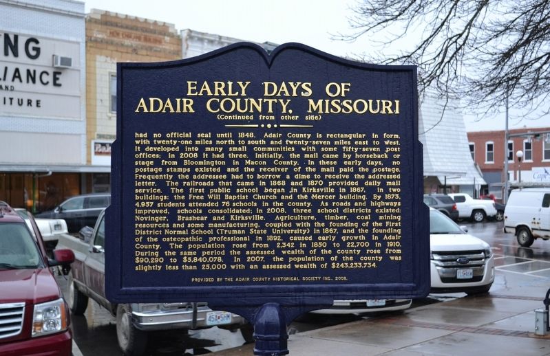
[Side A]
Internationally known for its firebrick industry and famed for its saddle horses, this county seat was laid out by Robert C. Mansfield and James H. Smith not long before Audrain County was organized, 1836. Named for legislator . . . — — Map (db m70508) HM
Presented to
Missouri Military Academy
in honor of its
One Hundredth Anniversary
1889 - 1989
by the
Mexico Area Chamber of Commerce
with deep appreciation and grateful
recognition of its 100 continuous years of . . . — — Map (db m70509) HM
On March 5, 1946, at Westminster College in Fulton, MO, Winston Churchill delivered his renowned "Iron Curtain" Speech. Allen P. Green built this gate in anticipation of a visit to his home by the former British Prime Minister and President Harry . . . — — Map (db m70531) HM
This valleys bountiful resources, particularly its abundant water, attracted settlers beginning in the 1820s. The constant rapid flowing of spring-fed Roaring River appealed to millwrights, who saw the opportunities such a reliable source of power . . . — — Map (db m68553) HM
Webster School was erected on this site in 1900. It was one of 3 schools to serve the East, West, & North neighborhoods. Known as North School, it was razed when the 3 grade schools were consolidated into Butler Elementary. — — Map (db m39907) HM
[Front]
Historic Harmony Mission, a school for the Indians of Missouri, once stood east of Rich Hill, on the north bank of the Osage River, near the centuries-old camping sites of the Great and Little Osage tribes.
The mission was founded . . . — — Map (db m121349) HM
The Sharp End was a thriving business district from 1910 - 1960. It disappeared through urban renewal and the use of eminent domain. John Lange Sr. and Annie Fisher were prominent business owners of a butcher shop and restaurant, . . . — — Map (db m169417) HM
Fifth Street Christian Church, founded as Second Christian Church, Disciples of Christ in 1861, is considered the first black church in the city. The first permanent church opened in 1879 at Seventh and Ash streets. With more than 200 . . . — — Map (db m169442) HM
Nora Stewart School opened in 1933 as the Negro Nursery School at 401 Park Ave. J.B. Coleman, an educator, owned the house and knew working parents needed a place for their children during the day. The school moved to the St. Paul AME Church and . . . — — Map (db m169444) HM
Gravesites for blacks were initially segregated in the south-central end of Columbia Cemetery near its intersection of Boone Road and Todd Drive. Blacks buried in this section include famed ragtime pianist and composer J.W. "Blind" Boone and . . . — — Map (db m169446) HM
Doby Flats—Stephen Doby, born on a S. Carolina plantation in 1854, came to Columbia about 1915. He built/owned Doby Flats (residential buildings) nearby and other houses. Wiggins Medical Clinic—Doby's daughter Ruth, a legendary teacher at . . . — — Map (db m169465) HM
Henry Kirklin (1858-1938) was a prize-winning internationally acclaimed horticulturalist. Born a slave in Columbia, he was freed at age 5. At age 14, he worked at Joseph B. Douglass' nursery, learning from European gardeners. Later, as a . . . — — Map (db m169474) HM
Come sit with Beetle Bailey, Mizzou's famous comic-strip character created through the genius of Mort Walker, AB '48 Humanities. Beetle relaxes in the re-creation of a booth from the Shack, a hangout frequented by Walker during his student days. . . . — — Map (db m87609) HM
Columbia, "Educational Center of Missouri", originated in the town of Smithton, laid out by the Smithton land Company, 1819. By 1821, when the name was changed, the town was the seat of Boone Co., organized 1820, and named for Daniel Boone who died . . . — — Map (db m106358) HM
Don Faurot
1902-1995
Football Coach 1935-42, 1946-56
Athletic Director 1935-67
Here stands the symbol of Ol' Mizzou, famed "Thin Man" from Mountain Grove, a boy who helped build this stadium and a football coach who filled it with . . . — — Map (db m59512) HM
First Professor of Geology, Chemistry, Agriculture, and First Dean of
The College of Agriculture
University of Missouri.
First State Geologist of Missouri. — — Map (db m59459) HM
Community leader, mentor, and educator for 56 years with the Columbia Public School District. During this time she developed and directed the Home School Communicator Program. This program, Mrs. Ralph's contribution to Columbia's Civil Rights . . . — — Map (db m169470) HM
In memory of
James Shannon L.L.D.
Born in Monaghan Co. Ireland
April 23, 1799
Died
Feb. 23, 1859
Second President, University of Missouri,
Columbia, Mo. 1850-1856
Co-Founder of Christian College 1851
(Now Columbia College), . . . — — Map (db m59462) HM
Jewell Cemetery is located on what was originally the farm of George Jewell. George, his wife, and their children first moved from Virginia to Kentucky, then Franklin, Missouri, and finally Columbia in 1822.
George, his son William, and . . . — — Map (db m59646) HM
Near this place James T. Scott, a Black janitor in the medical school at MU, was killed on April 29th, 1923. A mob brought Mr. Scott to the bridge, placed a noose around his neck, and pushed him over the railing while hundreds of spectators watched. . . . — — Map (db m169415) HM
In grateful memory
of these
Heroic Sons of Missouri
who in the Great War
- 1917 - 1918 -
paid the full measure
of devotion
[Roll of Honored Dead]
Tipping of the Hats
When the Memorial Union Tower was completed in 1926, . . . — — Map (db m59474) HM WM
[The marker features images from the MKT's history, as well as a map:]
A 1912 postcard view from East Broadway of the Katy's handsome Columbia passenger station. The impressive depot was built in 1909 and stands today. - Raymond B. . . . — — Map (db m169428) HM
On this site stood Columbia College an institution of higher learning for men. First proposed in 1831, chartered by General Assembly in 1833, began its work in 1834. First session of University of Missouri held here in 1841. This college has been . . . — — Map (db m59463) HM
During the early 20th century, the buildings at 4th and Broadway provided space where faith, music, and community converged. At 10 North 4th Street stands the home (c. 1890) of John William "Blind" Boone, a composer and concert pianist. His manager, . . . — — Map (db m169432) HM
Dedicated September 12, 2003, in honor of Mel Carnahan, Missouri's 51st Governor and alumnus of the University of Missouri. From his days as a law student at MU to his leadership as Governor of Missouri from 1993 - 2000, Mel Carnahan served his . . . — — Map (db m87607) HM
For nearly 250 years the country school was the backbone of American education. These simple buildings often served as school, chapel, town hall and community center.
One-room schoolhouses were the most common type of schools in the Midwest . . . — — Map (db m122675) HM
The Alpha Delta Chapter of Beta Theta Pi was chartered
by its General Fraternity on March 5, 1868.
Alpha Delta Chapter of Beta Theta Pi is the oldest chapter of any
collegiate fraternity or sorority in continuous existence
west of the . . . — — Map (db m119020) HM
Dedicated to the highest principles, President Robert L. D. "Larry" Davidson was a leader of character during times of both prosperity and adversity. As the 15th president of Westminster College, Davidson passionately invested in students, . . . — — Map (db m70395) HM
Rev. William W. Robertson, (1807-1894), Presbyterian minister and educator, established Fulton Female Seminary (1850) on W 7th Street, originally known as Seminary Street. Rev. Robertson founded Westminster College in 1853. — — Map (db m70423) HM
"The Columns" atop this hill are the venerated remains of Westminster College's original academic building, Westminster Hall, destroyed by fire in 1909. Founded in 1851, Westminster was one of the few Missouri colleges to function in some fashion . . . — — Map (db m70437) HM
"A reminder of the historic past and a symbol of strength for the future."
The Columns of Old Westminster Hall, built in 1858, preserved after the Fire of 1909, repaired by the Class of 1927 and rebuilt in 1972 by many loyal alumni. . . . — — Map (db m70419) HM
In memory of
William Chrisman Swope
1878 - 1909
Graduated from Westminster 1900
Faithful to every duty, self-sacrificing and helpful. A loyal officer in his church, a sincere and devout Christian
————— . . . — — Map (db m70421) HM
St. Vincent's Young Ladies' Academy was founded in 1839 by the Sisters of Loretto as a school for young women. Located at the corner of Spanish and Good Hope streets, it was one of the first schools for women west of the Mississippi. Prior to its . . . — — Map (db m107707) HM
George Washington Carver (1864-1943) was born in Diamond Grove, MO. As an agricultural chemist and inventor at Tuskegee Institute, now Tuskegee University, in Alabama, he developed a system of crop rotation. He also discovered 300 uses for . . . — — Map (db m192155) HM
Terrace Park is located on the site where Father Odin of the Congregation of the Mission (Vincentian Fathers) established St. Vincent's Male Academy in 1838, which was followed shortly thereafter by St. Vincent's Seminary.
Often affectionately . . . — — Map (db m58663) HM
This bell has been donated by the Rock School District of Cedar County Missouri in commemoration of the former Common School Districts which presently comprise the El Dorado Springs R-2 School District.
Cedar County
Barnes • Cedar Springs . . . — — Map (db m57417) HM
[Front]
"Come, drink, all who thirst for freedom: The water fountain will no longer separate us as a people."
During the Civil War era, one of every four Clay County residents was of African descent. Although sold in slave auctions and . . . — — Map (db m68207) HM
This property built in 1940
has been placed on the
National Register
of Historic Places
by the United States
Department of Interior
1993 — — Map (db m68235) HM
In 1849 William Jewell College was founded by Dr. William Jewell under the auspices of the Missouri Baptist Convention. Jewell Hall is on the National Register of Historic Places. Liberty Ladies College, a private college for women, was opened in . . . — — Map (db m68314) HM
Built in 1905 for William Jewell College by St. Louis business owner A.D. Brown. First occupants were Dr. John Priest Greene and Elizabeth Wikoff Greene. Dr. Greene was the longest-serving president of the College: 1892-1920 and 1921-1923. — — Map (db m152619) HM
A pupil of Mary Lyon,
Mt. Holyoke Seminary, Mass.
Twenty-five years a teacher in
Central and Western Mo., and
with her husband, James Love,
A.D. 1855, founded Clay Seminary — — Map (db m68110) HM
During the next four decades, Lincoln University surpassed all expectations, growing into a culturally rich and diverse institution. In 1954, when the United States Supreme Court made Brown v. the Board of Education the law of the land, Lincoln . . . — — Map (db m169380) HM
Lincoln University was founded by the black enlisted men of the 62nd and 65th United States Colored Infantries and their white officers who fought for the cause of the Union during the Civil War. The black soldiers of these two regiments . . . — — Map (db m169375) HM
Dedicated to the
Officers and Soldiers
of the
62nd and 65th
United States
Colored Infantries
The construction of the
Soldiers' Memorial Plaza
was inspired by
the vision of
Dr. David B. Henson
17th President of . . . — — Map (db m62284) HM WM
Lincoln University was founded by the black enlisted men of the 62nd and 65th United States Colored Infantries and their white officers who fought for the cause of the Union during the Civil War. the black soldiers of these two regiments were the . . . — — Map (db m169386) HM
Towards the end of the war, the men began to solicit funds to accomplish this dream. With some donating as much as a year's salary to the cause, they were able to collect more than $6,000. Their efforts resulted in the establishment of a school that . . . — — Map (db m169376) HM
With the deeding of its property to the state in 1879, Lincoln Institute formally became a state institution. Later, under the Second Morrill Act of 1890, the school became a land-grant institution. In 1921, the Missouri Legislature passed a bill . . . — — Map (db m169379) HM
Frederick Thomas Kemper, pioneering Missouri educator and founder of Kemper Military School in Boonville, was born at Madison Courthouse, Virginia. After graduating from Marion College in Palmyra, Missouri, he came to Boonville in 1844 and opened . . . — — Map (db m45974) HM
One of America's greatest painters, George Caleb Bingham, was known during his lifetime as "the Missouri Artist" for his depictions of frontier life and portraits.
Bingham was born in Augusta County, Virginia, March 20, 1811, and in 1819 the . . . — — Map (db m45975) HM
Born in slavery in St. Louis County, Mo.
Freed 1843
Founder, Elias Buckner African-American School in Boonville 1869 Established 32 Missouri schools for African-Americans in 1870
Secured state funding for Lincoln Institute (later Lincoln . . . — — Map (db m46016) HM
Born July 2, 1864, Boonville, Missouri
Died July 29, 1935, Columbia, Missouri
Editor - The Advertiser - Boonville, Missouri - 1884-1889
Editor - The Herald - Columbia Missouri - 1889-1908
Founder and Dean of First
School of Journalism . . . — — Map (db m45999) HM
[Side A]
DeKalb County, 270,720 acres of rolling prairie land, is one of 19 Missouri counties organized in February, 1845. The name is for German-born Johann Kalb, member of the French army and general in the American Revolution, known as . . . — — Map (db m88146) HM
Missouri Botanical Garden Arboretum
and Nature Reserve
has been designated a
National Environmental
Education Landmark
This site possesses distinctive values
in revealing significant natural and
cultural processes through . . . — — Map (db m186591) HM
Historic site of early Christian church and public school. Named to honor pioneer family whose members organized the first congregation in 1856. — — Map (db m169283) HM
Extended employment sheltered workshop programs in America began in the state of Missouri, in the city of Sedalia in 1965, when a parent campaigned for a vocational program to better the life of his disabled child; who was finished with school . . . — — Map (db m139733) HM
When the School Sisters of Notre Dame arrived in Washington in 1859, they lived in a house built from the logs of the first St. Francis Borgia Church. In 1860, the Parish built a new convent and school for the Sisters, known as St. Mary's . . . — — Map (db m169270) HM
St. Francis Borgia's high school program was established in 1901 with fourteen girls and nine boys in the first class. In 1933, its first four year, fully accredited, high school program was introduced. The 1935 school building was built to . . . — — Map (db m169268) HM
St. Francis Borgia Catholic Parish was established in 1834 and serviced by the Jesuit Missionaries from St. Charles, Missouri. The Parish's current church is the third church built and was constructed in 1869. The bell tower houses three bells . . . — — Map (db m169271) HM
Miss Krog taught German in the Washington Public Schools and piano lessons out of her home. She built this attractive home and lived here until her death in 1917. — — Map (db m124407) HM
A group supporting the Confederacy established this church under the leadership of Dr. Benjamin Burch. In 1883 it became the Crispus Attucks African-American School, later the Vocational Agriculture building for the Washington School District. — — Map (db m124406) HM
The cornerstone was laid for a new convent built large enough to accommodate future school rooms on June 15, 1890. In 1960, property was purchased nearby for a convent and the southern half of this structure was built to house a growing Catholic . . . — — Map (db m169273) HM
The mural turns the corner to face viewers approaching the Riverfront Park.
The evening sky turns to night.
The 1900's to the present are illustrated in the letters of "Missouri".
M - In 1907, Roberts, Johnson, and Rand Shoe . . . — — Map (db m124361) HM
This house was purchased by Zachariah and Amelia Foss in 1848. Zachariah was a cabinetmaker and Amelia was a teacher of English-speaking children. The house served as a school and is Washington's oldest surviving frame structure. The cellar was . . . — — Map (db m124369) HM
• From newspaper articles it is estimated that this Parade most likely occurred in the year "1911".
• Location: On South end of Main street near where Catholic church now stands.
• Owensville was built in the middle of a Prairie, thus you see . . . — — Map (db m139781) HM
Born December 24, 1931 in Hartville, Missouri
To William Thomas and Tina (Russell) Wynn
Sister to Jewell, Virginia, Marie, Lena, Tom Jr. and Russell
Graduated from Hartville High School in 1949, Southwest Missouri State College (now . . . — — Map (db m173449) HM
Southwest Missouri State University used a college housing loan from the United States Department of Education to purchase Kentwood Hall, formerly the Kentwood Arms Hotel, from the Kentwood Arms Hotel Company. The SMSU Board of Regents authorized . . . — — Map (db m173595) HM
Erected in 1876, stood 15 feet from this site until 1978. The hall was given to Drury by Mr. Charles Fairbanks of Tunbridge Wells, England as a memorial to his son, Walter. Fairbanks served Drury proudly as a home for over two thousand Drury . . . — — Map (db m79804) HM
This church is the second home of Springfield's oldest African-American congregation. It was constructed in 1885 on a site 200 feet due south of here, between Brower Street and Chestnut Expressway. In 2000, Drury University purchased a new home for . . . — — Map (db m170812) HM
Long recognized as a symbol of Drury College, Stone Chapel resulted from gift by Mrs. Valeria G. Stone, Malde, Mass., and named for her. Cornerstone was laid Nov.16, 1880. Fire loss delayed completion until 1892. Special features: first bldg. made . . . — — Map (db m67402) HM
Born to a sea captain in Portland, Maine, this energetic redhead was orphaned at a young age when her father died at sea and her mother died soon thereafter.
Mary wed John Smith Phelps, a young lawyer, in Simsbury, Connecticut, in 1837. The . . . — — Map (db m170896) HM
225 feet south of this spot the first school-house in Greene County was built by pioneers 1831. Small cabin, logs cut out for window and door openings. No shutter, door or chimney. Dirt floor. Three-legged benches. First teacher, Joseph Rountree. . . . — — Map (db m43064) HM
[side 1] Trenton, Settled in 1834, became the seat of Grundy County in 1841, when James S. Lomax gave 80 acres for a townsite. The county is named for Felix Grundy, United States Attorney General 1838-1839. The town name is . . . — — Map (db m179714) HM
1853 Joined The Christian Church.
Was an active member the remainder
of his life.
1861-1865 Served in The Union Army
1863 Ordained a Christian Minister
1866 Married Emeline Earnest
Organized Weaubleau Christian Church . . . — — Map (db m96093) HM
Weaubleau Christian Institute
Established 1867
John Whitaker
Founder of Weaubleau
Christian College
Born Aug. 15, 1842
Died Jan. 6, 1910
Weaubleau Christian College
Established 1893-1914 — — Map (db m96092) HM
This library was provided for in the will of Benjamin W. Lewis, whose fortune was made in tobacco, to the extent of $10,000.00. The building of Italian Renaissance architecture was erected in 1866 at a cost of $26,000.00 through the benevolence of . . . — — Map (db m216981) HM
In Spring 1866 Father Henry Meurs came to Glasgow at the request of area Catholics. Soon work was begun on Church building. Bricks purchased from McClinicks Brickyard, of Glasgow, for $10.00 per hundred. In 1897 church remodeled as Satolli Hall and . . . — — Map (db m216996) HM
Recognition is given to B.P. Burnham, then county superintendent of schools, for his originality foresight and leadership in organizing the first 4-H clubs in Missouri: one at a high school in Ironton, the other at the one room King School near . . . — — Map (db m99170) HM
Hiram Young came to Missouri as an enslaved African American. He earned his freedom step by step. First he purchased his wife Matilda's freedom in the early 1840s. For children to be free, they had to be born to a free mother. The Youngs welcomed . . . — — Map (db m208243) HM
The church had recently been built when the Truman family moved to Independence in 1890. Harry Truman attended Sunday School here for several years as a child with Bess Wallace. — — Map (db m34748) HM
Built by slave labor in 1826, the Jones H. Flournoy House is one of the oldest houses in Independence. It was originally located four blocks east of its current location. In 1831 church leaders led by church founder Joseph Smith, visited . . . — — Map (db m156379) HM
Organized in 1861, the present building was erected in 1886. The congregation has been a spiritual, educational and cultural leader. The first black school was held here.
Western Baptist Seminary was organized in this church. — — Map (db m144550) HM
This building has been erected by the gifts of American citizens in all walks of life and the generosity of the City of Independence and of the contractors who built it for the purpose of preserving the papers of President Harry S. Truman and . . . — — Map (db m44352) HM
The American Jazz Museum is an important cultural institution dedicated to its mission of celebrating and exhibiting jazz through performance, education, exhibitions and research at America's Jazz Crossroads - 18th and Vine.
There were four major . . . — — Map (db m98414) HM
This Building was originally constructed as the Paseo YMCA which opened in 1914 to provide Kansas citians of color a place that would specifically allow them a public or private multi-purpose facility serving as a meeting place for community . . . — — Map (db m98433) HM
Richard Thomas Coles
(educator)
Located here at 1835 Tracy, the R.T. Coles Vocational and Junior High School opened in 1936 in the building formerly occupied by Lincoln School. The school was named for Richard Thomas Coles in . . . — — Map (db m200145) HM
Named for Nathan Scarritt D.D. (1821-1890), whose first home on this site was a log cabin of his own building.
Dr. Scarritt, a leading citizen in Kansas City and the founder of Melrose Methodist Church, was instrumental in the establishment . . . — — Map (db m63921) HM
Built in 1855 by John and Henrietta Harris this Greek revival style all brick house was located on a slightly five acre tract on the ridge just east of Westport, MO. This site was on the southwest corner of Westport Rd. (Santa Fe Trail) and Main . . . — — Map (db m44411) HM