On Mamalahoa Highway (Hawaii Route 19) near Pauahi Street, on the right when traveling east.
(Legend to Points of Interest to on the Hilo Bay map:)
➊ Kānoe Heiau Kānoe Heiau was one of six major lauakini or sacrificial heiau on the island of Hawai'i dating back to ancient times.
➋ Naha . . . — — Map (db m111236) HM
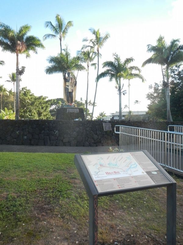
On Kamehameha Avenue near Lihiwai Street, on the right when traveling west.
Waiakea Town, or Yashijima, was a close-knit, vibrant community which occupied what is known today as Banyan Drive. The golf course and park that you see today was once filled with homes, businesses and Waiakea Kai School, all of which provided the . . . — — Map (db m110928) HM
Near Kaleiopapa Street, 1 mile north of Alii Highway, on the right when traveling north. Reported permanently removed.
Kauikeaouli was born within this enclosure March 17, 1814 the second son of Kamehameha I and Keopuolani. His reign (1825-1854) was the longest in the history of the Kingdom. While a minor, his kingdom knew the firm regency of Queen Ka'ahumanu, . . . — — Map (db m172848) HM
Near Kupipi Street, 0.1 miles north of Keahole Airport Road, on the right when traveling south.
These three dancers convey the grace and power of Hula Kahiko, the ancient dance of Hawai'i. The flow of their skirts and the harmony of their movements capture the rhythm of the dance which highlighted many sacred and ceremonial occasions. Just . . . — — Map (db m190119) HM
Near Kupipi Street, 0.4 miles north of Keahole Airport Road, on the right when traveling south.
In Hawai'i, the lei, a garland of flowers, coveys respect, love, friendship, and continuity of life. It may be created from a wide variety of local flora and is offered on many occasions calling for a special token. The giving of leis as a floral . . . — — Map (db m190121) HM
Welcome to Pu’ukohola Heiau, one of the most famous heiau (temples) in the Hawaiian Islands. This heiau is an integral component of the traditional Hawaiian social, political, and religious systems, and a significant place in the history of King . . . — — Map (db m71874) HM
On Alii Drive at King Kamehameha III Road, on the left when traveling north on Alii Drive.
Moku (island districts) were traditionally subdivided into smaller land wedges called ahupua'a. Generally, these ahupua'a extend from the mountain to the sea and contain all the resources needed for sustainable living. . . . — — Map (db m39438) HM
Near Ninole Loop Road, 1 mile Mamalahoa Highway (Hawaii Route 11) when traveling east.
The mystical turtle, Kauila, makes her home in the Ka’u District at Punalu’u Bay. According to Hawaiian mythology, Kauila was empowered with the ability to turn herself from turtle into human form and would play with the children along the . . . — — Map (db m129454) HM
On Holoholokai Beach Park Road, on the right when traveling west.
Man has always left his mark. Symbols in rock were left by many early civilizations. Te Puako Petroglyph site is one of the largest and finest concentrations of the mysterious symbols left in Hawai‘i. It is likely that many of these petroglyphs . . . — — Map (db m3029) HM
Near Waikoloa Beach Drive near Pohakulana Place, on the right when traveling east.
Kalama Hakaleleponi Kapakuhaili was the daughter of ali'i (royalty) Kaihekukui and Iahu'ula. She married Kauikeaouli Kamehameha III, who introduced the division and disbursement of traditional lands known as the "Great Mahele." A very well-educated . . . — — Map (db m110410) HM
Near Akoni Pule Highway (Hawaii Route 270), on the left when traveling north.
The ahupua'a is a traditional land division that runs mauka from the mountains to makai (seaward). The ahupua'a of Lapakahi encompasses more than 2,000 acres along the leeward slopes of the Kohala Mountains. The distance from the upland forests . . . — — Map (db m110324) HM
On Daniel K. Inouye Highway (Saddle Road) (Route 200 at milepost 27) near Mauna Kea Access Road, on the left when traveling east.
Traditional native uses of the Humu'ula area included bird catching and, at much higher elevations, adze quarrying. They were replaced by sandalwood harvesting and hunting wild cattle, and ultimately ranching and astronomy. Over time, travelers . . . — — Map (db m110792) HM
Near Spencer Beach Park Road, 0.2 miles west of Kawaihae Road (Hawaii Route 270), on the right when traveling west.
Build a heiau on Pu'ukohola, the "hill of the whale," dedicate it to your war god, and you will achieve your dream — you will rule the islands. Responding to this prophecy told by Kapoukahi, a famous seer, Kamehameha built the heiau . . . — — Map (db m172849) HM
On this site stood the villa of Chun Afong, Hawai‘i’s first Chinese millionaire, who arrived
in Honolulu in 1849. By 1855, he had made his fortune in retailing, real estate, sugar and rice, and for a long time held the government monopoly opium . . . — — Map (db m49676) HM
Near Holomoana Street south of Ala Moana Boulevard.
Fish were easily netted from the ponds near Pi‘inaio Stream.
In ancient times, the
area was home to many Hawaiian families, who enjoyed the offerings in its bountiful waters. It was not unusual to see native men and women fishing, . . . — — Map (db m13127) HM
From olden times Waikīkī was viewed not only as a place of peace and hospitality, but of healing.
There was great mana (spiritual power) in Waikīkī. Powerful kahuna la‘au lapa‘au (or physicians) lived here. Throughout the . . . — — Map (db m13225) HM
Near Holomoana Street south of Ala Moana Boulevard.
The legendary surfer Duke Kahanamoku often strolled the sands of Waikīkī Beach fronting what is now Hilton Hawaiian Village Beach Resort & Spa, 1959.
In ancient times, the coastal plain where you now stand was known as . . . — — Map (db m13082) HM
On Kalaukaua Ave, on the left when traveling west.
Legend says these stones are the living legacy of four powerful Tahitian healers who once resided near this site at a place called Ulukon. From the court of the Tahitian chief, the names of the four were Kapaemahu, Kapuani, Kinohi, and Kahaloa. . . . — — Map (db m73116) HM
On Ala Moana Boulevard (Hawaii Route 92) at Kalia Road, on the right on Ala Moana Boulevard.
Chief Ma‘likūkāhi, who reigned over the island of Oahu in the mid-1400s, resided in Waikīkī and used it as his seat of government. He was greatly loved by his subjects who enjoyed unprecedented peace and prosperity. Ali‘i . . . — — Map (db m13200) HM
On Kalakaua Avenue north of Saratoga Road, on the right when traveling south.
Honoring the World War II Veterans of the 100th Infantry Battalion (Separate), the 442nd Regimental Combat Team, the Military Intelligence Service, and the 1399th Engineer Construction Battalion.
“Veterans who served in these units, . . . — — Map (db m26939) HM
On Kalakalua Avenue at Kukio Avenue and Kuamoo Street, on the left when traveling south on Kalakalua Avenue.
(tablet on back of base)
David Kalākaua was born on November 16, 1836. He succeeded to the throne on February 12, 1874, and ruled with his queen, Kapi‘olani. King Kalākaua was the catalyst for the revival and flowering of . . . — — Map (db m13586) HM
On State Highway 56, on the right when traveling north.
The 15-foot cast concrete lantern was constructed in 1915 by Kaua‘i’s first generation Japanese immigrants. As a tribute to their homeland, the lantern commemorates the 1912 coronation of Emperor Taisho. An inscription reads: “Great Japan . . . — — Map (db m9786) HM
Near Kilauea Road, 1.8 miles north of Hawaii Route 56.
May the glimmer of both this historic lighthouse, guiding ships to safe harbor, and the legacy of Senator Daniel K. Inouye, illuminating the voices of Hawaii citizens, always continue to serve as beacons of hope.
'Ike vision, Lawelawe . . . — — Map (db m65776) HM
On Menehune Road north of Hawaii Highway 50, on the left when traveling north.
The row of hewn stone along the inner side of the road is a remnant of one wall of a water-course which is said to have been made by the MENEHUNES (Hawaiian dwarves or Brownies)
The stones were brought from Mokihana
There is an old . . . — — Map (db m27646) HM
In the distant future, when our descendants ask, tell them here lies the first altar made by Korean American Christians.
Today, when more than three thousand Korean churches in America, along with their members ask, tell them you all are . . . — — Map (db m73191) HM