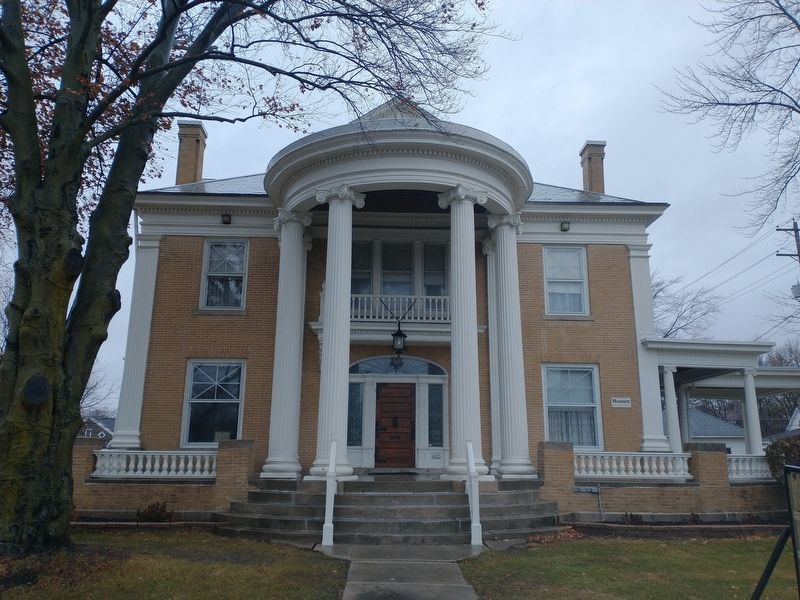
This
Charles A. Dugan Mansion
Circa 1902
has been listed in the
National Register
of Historic Places
by the
United States
Department of the Interior. — — Map (db m211618) HM
Around the turn of the century, the nationwide “City Beautiful” movement found local expression through the efforts of Charles Mulford Robinson and nationally known landscape architect George Kessler. Seeking to reclaim the natural beauty of our . . . — — Map (db m17034) HM
The concrete retention walls at the north end of the
plaza will help downtown Fort Wayne withstand future
flooding when the rivers rise. They were constructed
where sandbaggers and volunteers worked during the
flood of 1982 to build a dike to . . . — — Map (db m197138) HM
9 January 1865. Patrick H. Keegan sold this half-lot to carpenter James C. Dillon who built a frame, one, and one-half story house.
28 June 1889. His three daughters sold this house to Patrick H. Keegan.
21 April 1914. Mr. . . . — — Map (db m197188) HM
Kresge-Groth
Building
c. 1926
has been placed on the
National Register
of Historic Places
by the United States
Department of the Interior — — Map (db m197144) HM
Louis Mohr Block
has been placed on the
National Register
of Historic Places
by the United States
Department of the Interior
Built 1891 — — Map (db m197195) HM
In 1852 John Brown, a stonemason, built this last remaining vestige of the early canal era in FortWayne.
A native of Glasgow, Scotland, Brown came by canal boat to Allen County in 1847 with his wife Mary. He and his Scottish business partner, . . . — — Map (db m100141) HM
Henry Rudisill, whose efforts had resulted in the establishment of Fort Wayne's first German Lutheran congregation in 1837, also initiated the founding of the community's first English-speaking Lutheran parish, the English Lutheran Church of the . . . — — Map (db m197187) HM
County formed by Indiana General Assembly 1821. Thirty acres of land were purchased, and John Tipton donated thirty acres, for county seat. State commissioners named county seat Tiptona — after Tipton; local elected commissioners renamed it . . . — — Map (db m48105) HM
Benton County formed by General Assembly in 1840. Oxford first county seat; Fowler became second, 1874. Designed in Second Empire Style by Gorden P. Randall and built 1874 by Levi L. Leach. Located at geographical center of county on land donated by . . . — — Map (db m21487) HM
Building A Home
Felhng 40 or so logs in the forest 15-26 inches in diameter for the sides and ends
the settler had only to add three or four shorter ones for the gables. Each end was
notched to both secure one log with the next and to . . . — — Map (db m163318) HM
Delphi Courthouse Square Historic District
has been placed on the
National Register
of
Historic Places
by the United States
Department of the Interior
— — Map (db m161448) HM
The Wabash & Erie Canal conference
and interpretive center before you
combines historic facades from 1850s
downtown Delphi.
J. H. Stewart Drugs, Callahan Boots and Lathrope
Bakery fill the middle of the block in this 1850s . . . — — Map (db m163275) HM
Logs were part of the railroad trestle at Pittsburgh removed in the 1930s. They became a lakeside cottage on Freeman Lake known as "The Oaks". Logs were donated by the families of: Grantham, Israel and Goyer in 2019 — — Map (db m163338) HM
A Small Construction Camp Shanty
This Canal worker's shanty is constructed of actual canal-era
timbers. Plain and simple, these temporary structures provided
for the workers - offering a place to sleep, argue, joke, gamble,
mediate and . . . — — Map (db m163337) HM
Carroll County Wabash & Erie Canal, Inc.
Founded in 1974, in Delphi, Indiana, Carroll County Wabash & Erie Canal, Inc. is dedicated to the
preservation of the stretch of the Wabash & Erie Canal located in Delphi, Indiana. Approximately . . . — — Map (db m163280) HM
Carroll County Wabash & Erie Canal, Inc.
Founded in 1974, in Delphi, Indiana, Carroll County Wabash & Erie Canal, Inc. is dedicated to the
preservation of the stretch of the Wabash & Erie Canal located in Delphi, Indiana. Approximately . . . — — Map (db m163355) HM
Street celebrations and parades were very common in the past and much better attended than some are today. In the picture of what is now Red Yeti, you will notice that the crowd has assembled in front of an Army Surplus store. Post World War II, . . . — — Map (db m206921) HM
This Italianate style building had multiple uses. The first floor was the bank and the second floor was office space and meeting rooms. It had a basement with access on the south side and, in the 1890s, the Lyon family was walking here when they . . . — — Map (db m206922) HM
County formed by Indiana General Assembly 1825; named for national statesman Henry Clay. First county seat at Bowling Green; had three courthouses: first built 1827 was two-story log structure; second and third built 1839-1840 and 1852-1853 were . . . — — Map (db m18883) HM
Old Stoney was built in 1892 and served as the Frankfort High School. On February 24, 1922 there was a fire that completely gutted the building, leaving only the four walls. Using the original walls, the building was rebuilt and reopened on . . . — — Map (db m232389) HM
Mission Revival Style depot, built 1906, restored 1990; part of Washington Commercial Historic District. Link to city's trading and industrial history, with substantial railroad machine shops and car works. Indiana stop of former President Dwight D. . . . — — Map (db m23214) HM
First Presbyterian Church
of Aurora
1844
has been placed on the
National Register
of Historic Places
by the United States
Department of the Interior — — Map (db m201098) HM
Originally called Forest Hill, Hillforest was completed in 1855 for local industrialist and steamboat owner Thomas Gaff and his family. Emigrants from Scotland in 1811, the six Gaff children moved with their mother to Aurora in the 1840s and . . . — — Map (db m22125) HM
Hillforest
Following the Panic of 1837, Philadelphia Distiller Thomas Gaff and his brothers James and John sought new opportunity in southern Indiana, where in 1843 they established T. & J.W. Gaff & Co. Distillery in Aurora, Indiana. Soon . . . — — Map (db m201095) HM
Architect William Tinsley of Cincinnati was known throughout the Midwest for his outstanding landscape designs, including Fountain Square in Cincinnati. Riverview Cemetery on the banks of the Ohio is a splendid example of his work. It is reflective . . . — — Map (db m222258) HM
Founded 1816 as Methodist Episcopal church
Present building constructed 1853
National Register of Historic Places 1994
Plaque in memory of Kenneth Pitts — — Map (db m222252) HM
Dr. George Sutton was prominent in
Aurora and far and wide. A forward
thinker, he was instrumental in bringing
an end to cholera which wiped put a
large percentage of the population in
the Ohio Valley in 1849. Dr. Sutton did
extensive study . . . — — Map (db m222254) HM
In 1922, both storefronts of this c. 1860 Italianate building housed a bakery. The ovens and baking rooms stretched to the alley. Earlier, other businesses occupied one storefront, including a confectionary and a book and stationary seller. — — Map (db m226656) HM
The Hamline Chapel United Methodist Church was organized in 1806. In 1847, the members of the congregation and Lawrenceburg citizens donated funds to construct this Classic Revival style chapel. The brick sanctuary and wooden steeple serve as a . . . — — Map (db m222802) HM
The Art Deco style Klausing Building from the 1930's was a Packard dealership until the late 1950's. It was later converted into a bowling alley. Walnut Bowl was a twelve-lane bowling alley until the 1960's. — — Map (db m226658) HM
Dr. George F. Smith came to Lawrenceburg in 1905 and opened his own practice in this home. Locals consider his home to be Lawrenceburg's first hospital. The Federal style home was built in 1857.
Lawrenceburg Heritage Plaque Program
a . . . — — Map (db m187435) HM
This Federal style building is a fine example of a three part commercial block. Local tradition asserts that this building was the location of a large cigar factory during the nineteenth century. Later the block became known for the nickel and dime . . . — — Map (db m226657) HM
The Regular Baptist Church of Lawrenceburg was the city's first Baptist congregation. The congregation organized in 1807 and met in various locations around the area. In 1846, this church was built in the Gothic Revival style. The building was . . . — — Map (db m187438) HM
Early fine quality Federal style home of Samuel Vance, built 1818. Military associate and friend of William Henry Harrison. Vance founded Lawrenceburg in 1802. River Boats landed on the grounds, and guests reached the mansion through an avenue of . . . — — Map (db m200326) HM
L. Kohlerman, a local undertaker built
this example of Italianate architecture
c. 1875. In the 1860's and 1870's,
the streets in Lawrenceburg were
raised because of flooding from the
Ohio River. The first floors of
buildings were covered and . . . — — Map (db m222708) HM
Built by James Angevine
in York Township around 1830.
The Angevines left New York City
and traveled to Indiana where they
purchased over 1,000 acres of
land in York Township.
James and Susan Angevine
raised 12 children in this cabin
until . . . — — Map (db m222831) HM
James and Susan Angevine moved to
York Township in Dearborn County
in 1818 from New York. This is
the second cabin they built on their
property (c.1820). The Angevines
raised their children in this cabin until
1830. The cabin was used as a . . . — — Map (db m222830) HM
This Italianate building was originally
the First National Bank of
Lawrenceburg, one of three local
banks. It was built c. 1863 by Martin
Tittle, a local master brick mason.
Tittle built many of the city's
prominent buildings during . . . — — Map (db m222795) HM
This Greek Revival style church
was built in 1860 to replace the
congregation's original church, located
on East Center Street near the
marketplace. In the 1930's the
Fraternal Order of Eagles purchased
the building and occupied it for
many . . . — — Map (db m222847) HM
Judge Isaac Dunn owned two
houses at High and Elm Streets.
The larger on the northeast corner
was built after Dunn married the
widow Harriet Hunter in 1843.
This Greek Revival home was
more elaborate than Dunn's
other home, built in . . . — — Map (db m222759) HM
The Liedertafel, a musical group
of German immigrants, built the
Liedertafel Hall in 1893. The
Italianate theater hosted Liedertafel
performances, dances, moving
pictures and vaudeville acts.
The name was changed to Liberty
Theater during . . . — — Map (db m222713) HM
This Italianate building constructed
in 1885 was originally a buggy and
carriage factory for Helfer and
Woodward. The carriages were sold
mostly in the South. Lewis Adler
bought the building in 1861. Adler
remodeled the first floor to . . . — — Map (db m222729) HM
Lawrenceburg was founded in 1802 by Captain Samuel Vance, a U.S. Government surveyor who purchased the land that would become Lawrenceburg. With the beginning of steamboat shipping after the War of 1812, came the evolution of the city's historic . . . — — Map (db m222744) HM
This Queen Anne style train depot,
built by the railway company
c.1900, served passengers on the
Saint Louis Division of the
Baltimore & Ohio Railroad
until 1972. This brick depot
replaced an earlier wood frame
depot from c. 1850. — — Map (db m222840) HM
James B. Weddle built the
Walnut Theater in 1925. Weddle
and his son ran the theater until
they sold it in 1978. The interior
was remodeled after the 1937
flood to reflect the popular Art Deco
style of the time. The large
marquee was added in . . . — — Map (db m222712) HM
Original college building,
directly southwest of this
point, was erected 1854-56
with financial assistance by
Freemasons of Allen Lodge
No. 165, who used third floor
as meeting hall until edifice
destroyed by fire, 1915. — — Map (db m222244) HM
Built c. 1873 by Dr. William Bracken, this excellent Italianate commercial building displays decorative cornice work and unique rope trim on the upper window hoods. Dr. Bracken originally lived and worked in the west portion, which later housed a . . . — — Map (db m241665) HM
Built in 1922, The Citizens’ National Bank (established 1871) building displays the Neo Classic / Classical Revival style, featuring an arch, dentils, and both Doric and Tuscan columns. The Greensburg Building and Loan Association later occupied the . . . — — Map (db m207373) HM
The original federal style building on this location was built c.1850, with Italianate ironwork columns and lower level storefront windows added c. 1875, utilized as a hotel, the Citizen's National Bank, and the South Side Theatre, the structure was . . . — — Map (db m241662) HM
Built c.1850, this Italianate commercial building was used to house the courthouse offices during the construction of the present courthouse from 1854 to 1860. It also housed a community center (Washington Hall) which doubled as the publishing site . . . — — Map (db m241663) HM
Constructed c. 1860 in Classical Revival style, it displays a unique parapet front gable roof with wood topped "steps.” At least four food distributors were located at this site, including Kammerling's Meats in 1908, the Model Grocery in 1914, . . . — — Map (db m187666) HM
Built circa 1865 by Abraham Reiter, this 3-story Italianate style commercial building continuously housed a series of dry goods companies for over 75 years. After a period of vacancy, in 1948 Holthouse Furniture occupied the space for 10 years. This . . . — — Map (db m207370) HM
Once featuring a cupola at its peak, this 1867 structure displays Italianate Commercial architecture. The only building with four stories, it was first known as the Seitz House Hotel in 1886 and remained a hotel for over 30 years. It housed the . . . — — Map (db m207335) HM
The bay window and ornamental corners of this building represent one of the few examples of Queen Anne architecture in the Courthouse Square district. Built in 1908 b George Erdmann, it originally housed a saloon. Later Roy C. Kanouse, known as “The . . . — — Map (db m207274) HM
In 1893 Robert Naegel built this two-story structure featuring an elaborate metal facade that reflects a combination of Italianate and Queen Anne architecture. The Capital Finance Corporation was located here for nearly 40 years, beginning in the . . . — — Map (db m44947) HM
The west side of this 1885 Italianate commercial style building was occupied by the Fair Store from circa 1908 to 1972. Hunter’s Pharmacy replaced the variety store and continued there until 2000. The upper story housed the G.A.R. Hall for nearly 30 . . . — — Map (db m207262) HM
Civil War hero Col. John T. Wilder built this Italianate structure in 1865. The mansard roof and decorative trim added a year later reflected the newly-popular Second Empire architecture., making it the first 3-story building in Greensburg. The . . . — — Map (db m207273) HM
Believed to be one of the oldest buildings in the district, this Federal Style building constructed circa 1850 displays the low-pitch gable roof indicative of the period. The structure has housed numerous businesses, one of the earliest known being . . . — — Map (db m207260) HM
Auburn Automobile Company (1900-1937) Art Deco Style Administration building, built 1929-1930. Housed departments of Cord Corporation, manufacturer of Auburn, Cord, and Duesenberg automobiles. Became Auburn-Cord-Duesenberg Museum, 1974; listed in . . . — — Map (db m53934) HM
This building was originally called
Richwoods Church for the dense growth
of black walnut and other valuable
timber in the area. The founding
pastor was Rev. Samuel Sayford, who
with his wife Mary, moved from Virginia
and ministered on . . . — — Map (db m231348) HM
This imposing home was built by businessman, George Riley Jones and his wife, Margaret, in 1901-1903. Alfred Grindle, the architect, designed this Colonial Revival style building. The Jones' enjoyed and occupied this house during their lifetime.
. . . — — Map (db m231344) HM
The two blocks of granite placed here were salvaged from the W.A. McNaughton Building, which was demolished in 1989. They were design elements of the main entrance on Walnut Street. The building was constructed in 1901 at the south east corner of . . . — — Map (db m141269) HM
Steven and Todd Murray, Community Development, and the Urban Enterprise Association renovated the exterior of this building back to its original design character and renamed it the Murray Building. — — Map (db m222319) HM
This property
Boyce Block
has been placed on the
National Register
of Historic Places
by the United States
Department of the Interior — — Map (db m222323) HM
Goldsmith C. Gilbert, New York trader and miller who came to Delaware County in the early 1820s and operated a trading post on the Mississinewa River, acquired the Hackley Reserve and erected a cabin on this square in which his daughter, Mary Jane, . . . — — Map (db m222292) HM
1986 Althea Stoeckel Award
presented to:
Muncie Public Library
Main Branch
Listed on the National Register
of Historic Places
June 17, 1976
for the
interior renovation of the main library
301 E. Jackson Street
presented by . . . — — Map (db m222324) HM
built 1927
Listed on the
National Register of
Historic Places by the
United States Department
of the Interior,
February 17, 1989 — — Map (db m231343) HM
Bucklen Opera House
1884 - 1986
Main and Harrison Streets
Commissioned by: Herbert E. Bucklen
Architect: Unknown
General Contractor: Unknown
The Bucklen Opera House, built in 1884 on the northwest corner of Main and Harrison . . . — — Map (db m64642) HM
(Side one):
Added many buildings to the architectural significance of Elkhart, Goshen, and Nappanee. Born mid-1850s in England; his family moved to Elkhart early 1870s. In mid-1880s he moved to Chicago; worked until 1890 with architect . . . — — Map (db m32728) HM
Erected by Albert R. Beardsley
Placed on the National Register of Historic Places November 28, 1978 by the United States Department of the Interior in cooperation with the Indiana Department of Natural Resources Division of Historic . . . — — Map (db m76259) HM
Elkhart County was formed by the Indiana General Assembly 1830; the first county seat was located in Concord Township. County commissioners relocated the county seat to Goshen 1831. Jacob Studebaker, Goshen, designed first brick courthouse, . . . — — Map (db m30157) HM
Indiana's first Carnegie library opened here 1903 with 3, 000 volumes. Goshen Library Association received $25, 000 in Carnegie grants 1901. Public donations, land purchase, and tax levy met Carnegie grant conditions. Architects Patton & Miller, . . . — — Map (db m32724) HM
Erected 1831 by Oliver H. Smith. Later home of Caleb B. Smith, Secretary of Interior under Lincoln and Grand Master of Indiana Masons. Restored 1941 as home for local Masonic bodies. — — Map (db m44768) HM
Heineman Corner, Site of John Conner's 1820 Trading Post
Canal House - Built 1842
Alligator Drugs - 613 Central
Farmers & Merchants - 416 Central — — Map (db m222139) HM
French Second Empire Style structure. Construction began 1867 for William Stewart Culbertson (1814-1892), leading industrialist, financier, and philanthropist in New Albany area. Listed in National Register of Historic Places, 1974; accepted as . . . — — Map (db m180500) HM
[side 1] William S. Culbertson, wealthy merchant, opened home November 18, 1873 to provide food, clothing, and shelter for town's destitute widows. Home had gas lighting, upstairs water closet, and up-to-date kitchen. Residents' lives were . . . — — Map (db m180503) HM
The roof of this gazebo was built in 1915 to replace the spire from the bell tower of the
church after it was destroyed by lightning. After 101 years, it was removed to be replaced
with a replica of the original spire. Its intact removal by the . . . — — Map (db m207041) HM
Isaac P. Smith, early contractor and master builder, obtained the land from the original Scribner grant, and built the home for his family who retained ownership throughout the years. The original iron fence was donated to the scrap drive during . . . — — Map (db m207015) HM
When Joel, Abner and Nathaniel Scribner settled strategically below the Falls of the Ohio, they named New Albany for Albany, New York. The town became the county seat, and was a hub of steamboat activity. Mary industries thrived, including machine . . . — — Map (db m207008) HM
Site of farmer's market before 1826. First stalls in market house were sold at public auction October 25th, 1826. Also used as community center, last market house torn down March, 1937. — — Map (db m207042) HM
[side 1] New Albany lots were advertised for sale 1813. It was designated county seat 1819, incorporated as town 1836, then as city 1839. Area within the district was part of early plat of New Albany. District boundaries are roughly West 1st . . . — — Map (db m180493) HM
431 entries matched your criteria. The first 100 are listed above. Next 100 ⊳