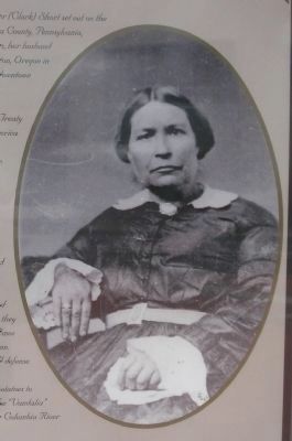
After marrying Amos Short in 1829, Esther (Clark) Short set out on the adventure of her life! Originally from Tioga County, Pennsylvania, Esther Short, who was ½ Algonquin Indian, her husband Amos and 10 children traveled west to Linton, Oregon . . . — — Map (db m64239) HM
Kendall Skyline Road
This scenic mile-high road completed in 1928, was conceived,
promoted, surveyed, and built under the direction of
Wm. H. Kendall
to whose memory it is dedicated by the people he
served so well and by the United . . . — — Map (db m232674) HM
Welcome to Palouse Falls, Washington's official state waterfall. Behind this designation by the state legislature is a story of how local students with a vision created state law - and made state history.
Waterfall Facts Palouse Falls is . . . — — Map (db m129494) HM
Directly across the Columbia River is Ginkgo Petrified Forest State Park, covering 6,000 acres.
Although the presence of petrified wood had been reported as early as 1898, the first indication of its presence in quantity in this vicinity was . . . — — Map (db m92611)
In 1968, a seemingly simple zoning request kicked off a fight over the future of Central Whidbey Island.
When proposed development threatened to cut off access to a beloved beach and replace the heritage farmland you see today with subdivided . . . — — Map (db m196842) HM
You are standing in the nation's first historical reserve, a unique unit of the National Park Service.
The Reserve was originally championed by a group of concerned residents in the 1970s when Ebey's Prairie was subdivided for large-scale . . . — — Map (db m179320) HM
Ebey's Landing, the nation's first National Historical Reserve, was established by Congress in 1978 "in order to preserve a rural community which provides an unbroken historical record from nineteenth century exploration and settlement in Puget . . . — — Map (db m179349) HM
...came to Whidbey Island in 1895 as a young lawyer and stayed, having been struck with a life-long love of its beauty. Served as Island County Prosecuting Attorney 1896-1907, and Superior Court Judge for Clallam, Island, and Jefferson Counties . . . — — Map (db m179283) HM
From the end of the Lake Ozette Road, 2 trails lead to the ocean beaches. One, the Indian Village Trail, leads to the site of an abandoned Ozette Indian village at Cape Alava. For over 2000 years, Cape Alava was home to the Makah Indians. . . . — — Map (db m179353) HM
It's hard to imagine Deception Pass without the bridge. But until 1935, the gap between Fidalgo Island and Whidbey Island could only be crossed by boat. In 1924 a small ferry called the Deception Pass began running between Yokeko Point . . . — — Map (db m74083) HM
Just as the cabin tells a story of the site's history, so does nature. The large stumps in the area tell about early logging activity. Notice in the photo how different the cabin must have been with an expansive view before the new forest . . . — — Map (db m115751) HM
Emory Finch, the son of Hoodsport pioneers, moved into Interrorem with his new bride Maybelle Peterson on their wedding day, April 22. 1908. Like her husband, she saw at home in the outdoors. The couple met when she and two friends came over from . . . — — Map (db m116139) HM
Interrorem Ranger Cabin is the oldest Forest Service dwelling on the Olympic Penninsula and one of the oldest in the Northwest.
As you gaze through the trees at Interrorem Ranger cabin, step back in time to the Spring of 1907. From this spot you . . . — — Map (db m116138) HM
The name Interrorem, according to the most popular theory, was derived from Latin meaning "between the gold". Others believe it was slang for "Interim," used by those who thought the cabin would be a temporary site for managing the forest. Instead, . . . — — Map (db m116137) HM
Early Forest Rangers were custodians of the forest, riding horseback over mountain trails and camping out, protecting the forest from fires, poachers, and trespassers.
Most were outdoorsmen, former cowboys, trappers and woodsmen. They were hired . . . — — Map (db m116140) HM
It is no wonder that the churning fishing hole one mile down this trail is called Ranger Hole. Emery Finch, and many other early Rangers were avid fishermen, wearing a well traveled path between the cabin and their favorite fishing spot. Fishing was . . . — — Map (db m116141) HM
The Haller Statue and Fountain was donated to the city by Theodore N. Haller "in memory of early pioneers."
After the dedication speech in 1906, Mr. Haller read a poem about the Greek sea nymph, Galatea, and the statue has been known . . . — — Map (db m179703) HM
Dedicated May 21, 1948
as a lasting tribute
in honor of those from
Jefferson County
who sacrificed their lives
for their country
in the two World Wars
1917 • World War I • 1918
James A. Anderson · Fred W. Anderson · John W. . . . — — Map (db m179733) HM
Here in the wind-buffeted rain shadow of the Olympic Mountains grow colorful relics of the last ice age. The tiny prairie before you is a remnant of once extensive grasslands that followed the retreat of continental ice over 10,000 years ago. . . . — — Map (db m179767) HM
This site is the last remaining vestige of the natural prairie that spanned the qatáy Valley, between wetland areas. Relatively dry, upland areas of the valley provided camas bulbs (qʷɬúʔi in Klallam and Camassia quamash in Latin) . . . — — Map (db m179762) HM
Inspired by the park's many resident crows, this clever corvid reminds us that a drive-in restaurant once stood at this site. Intended as a whimsical landmark for
Auburn's beloved Les Gove Park, this sculpture is meant to capture the attention of . . . — — Map (db m224098) HM
Presented April 24, 1926
Dedicated Aug. 20, 1933
by
Seattle, Tacoma & Associated
Young Men's Business Clubs
Co-Sponsors
Seattle Star and Tacoma Times
9-10-39 — — Map (db m180095) HM
The Celebration Rose Garden was initiated in 2004 by the Seattle Rose Society through the vision and efforts of Seattle Rose Society member Lori White.
The planning and maintenance of the Rose Garden during its early years was carried on . . . — — Map (db m178625) HM
The story of the Elda Behm Paradise Garden is also the story of the Highline SeaTac Botanical Garden.
It is the story of Elda's love of gardening and how a community came together to express and share that love. Many of the plants in the . . . — — Map (db m178573) HM
These roses honor the legacy of the women
who made history on our Home Front during WWII.
They are part of a national "Living Memorial" to inspire
a new generation of 21st century Rosies. — — Map (db m178624) HM
Seike Family History
Shinichi Seike immigrated from Ehime, a southern Japanese island, in 1919 and ran an import/export business in Seattle. In 1929 he purchased 13 acres near Des Moines Memorial Drive and moved into a farmhouse along with . . . — — Map (db m178673) HM
This Victory Garden or Food Garden for Defense was planted in 2019 in commemoration of the over 20 million victory gardens planted across the U.S. during World War II. The orchard in the Neighborhood Heritage Garden is over 50 years old and was . . . — — Map (db m178622) HM
In a city built around water [illegible] getting around can be difficult. Interstate Freeway 5 bisects Seattle, creating a major north-south corridor when it was built in the 1960s. However, it did not permanently divide the city's downtown to the . . . — — Map (db m235223) HM
History
The dinosaurs standing before you did not start their life here in Fremont on the shores of the ship canal. Built in the 1980's for an exhibit at Seattle's Pacific Science Center, the dinosaurs topiaries were about to be destroyed . . . — — Map (db m235250) HM
The original donation of the land by the Kinnear family, the neighbors who donated the first plants to be installed in the park, and the many celebrations held in the park over the years demonstrate the community's love for the park.
1893 - . . . — — Map (db m112940) HM
This landscape was built by ancient lava flows and sculpted by powerful Ice Age floods. Clues to this fascinating past are all around you.
Remains of a Fossil Forest
The park contains hundreds of pieces of petrified wood that were . . . — — Map (db m82824) HM
1882 • Earliest burial.
1897 • A.H. and Jennie Jewett deed the property to the Board of School Directors of District #19.
1914 • Property deeded to City of White Salmon.
1922 • Last burial.
1955 • Property converted . . . — — Map (db m129499) HM
In the past two centuries there have been many changes at Beard's Hollow. Historically, the Chinook Indians visited the tide pools near the water's edge to collect sea life for food and shells to use as tools and decorations.
When the Lewis and . . . — — Map (db m116578) HM
Advertised as a place "where the flowers and the glaciers meet,” Paradise Inn opened on July 4, 1917. Here tourists arrived wearing long skirts and woolen traveling suits, "seeking a renewal of spirit in the vast world out-of-doors.”
Today, . . . — — Map (db m129378) HM
In the late 1800s and the first decade of the 1900s, this was the corner of a 10-acre park extending from People's Dock to today's Pioneer Way. It had rustic tables, an outdoor dance floor, and a mineral water spring. It was a place for picnics . . . — — Map (db m179998) HM
City welcomes favorite carver to create masterpiece at local park. An epic marine and wildlife totem for the community of Gig Harbor to enjoy.
What you can find in the sculpture:
Birds: Eagle, Hawk, Owls, Seagull, Heron, King Fisher, . . . — — Map (db m179912) HM
Crescent Creek runs three miles from Crescent Lake to the bay. Early on, families began to homestead in Crescent Valley, making their living through ranching, farming, and dairy operations. Joseph Goodman, a Civil War veteran, brought his family . . . — — Map (db m179911) HM
Andrew and Bertha Skansie purchased this property just after the turn of the century, first building a cabin on the beach. In 1910 they constructed the brick home. Andrew was a young but accomplished stone mason, bringing the skill from Croatia . . . — — Map (db m179984) HM
SETTLING THE WATERSHED
Historically, Crescent Creek watershed was altered by human settlement through logging and farming. Today shoreline development continues to alter the watershed.
PHOTO: Dr. Hiram Herbert Rust on Crescent Creek . . . — — Map (db m179917) HM
This building is dedicated to the Sehmel Family,
pioneers of the Gig Harbor Peninsula
[photo of the Sehmel house]
W.L.C. Henry Sehmel homesteaded in the Rosedale area in 1884. In 1887, Henry married Dora Gummert. Dora made her way to . . . — — Map (db m179887) HM
Documented history of Puget Sound began in 1792, when Captain George Vancouver, sailing for King George III of England, explored and charted this expansive waterway. He named the large inland waterway Puget Sound for his first mate, Peter . . . — — Map (db m180081) HM
Captain Charles Wilkes, commanding a United States exploring expedition, visited this vicinity in 1841 and left the names Point Defiance, Neill Point, Commencement Bay, Maury Island, Robinson's Point, Colvos Passage, Gig Harbor and Fox Island. . . . — — Map (db m223943) HM
John Bapiste LePage (1857-1939), the French-Canadian artist and architect, designed this unique memorial park and supervised its construction by local volunteers. Great Northern Railroad donated the park site, and costs were paid by contributors . . . — — Map (db m74362) HM
The extent of glaciation is one of the features that distinguishes the North Cascades from the rest of the Cascade Range. The northernmost reaches of the range were covered by huge continental glaciers, nearly a mile thick in places, resulting in . . . — — Map (db m196816) HM
The 1980 lateral blast shot hot rock, ash and debris northward at hundreds of miles per hour. For three minutes, the blast pummeled slopes facing the volcano, like those on your right, leaving few survivors. Slopes closest to the volcano were . . . — — Map (db m190631) HM
The Legion Park overlook allows a glimpse into the distant past. Here the panoramic view of Port Gardner Bay extends all the way to Mukilteo, and includes views of Smith Island, Priest Point, Camano, Jetty and Gedney (Hat) Islands. On a clear day . . . — — Map (db m135694) HM
On this scenic knoll about Port Gardner Bay, Wyatt and Bethel Rucker built a large family residence in 1905. This was a visible sign of success for the Ruckers who arrived at the peninsula as pioneers of modest means in 1889.
The Ruckers began . . . — — Map (db m235622) HM
Sirita's playground was built in August 2007, by the Lake Stevens Community in memory of Sirita Jimmina Sotelo. Special thanks to Gary & Magda Malkasian and all foster parents who open their homes and hearts providing a safe haven for children . . . — — Map (db m178921) HM
Welcome to a walking tour of Mukilteo Lighthouse Park and Mukilteo's historic light station. We hope you enjoy this walk, learning more about Mukilteo and its lighthouse. The tour is fully accessible, and restrooms are located here in the park. . . . — — Map (db m178833) HM
Before the arrival of the railroads in 1889, the riverbank west of the Division Street Bridge to Park Street (now Browne) cut southward then turned west. Lumber in sheds and open stacks, and W.R. Marvin's Planing Mill & Sash and Door Factory crowded . . . — — Map (db m148681) HM
Whereas, in recognition of the friendship and good will existing between the citizens of the City of Spokane and our neighbors to the north, the People of Canada, the City of Spokane has named, on April 8, 1974, an island in the north channel of . . . — — Map (db m154272) HM
The early 1970s were a time of growing environmental awareness and a worldwide desire to reduce pollution, recognize and protect endangered species and take better care of the planet. Spokane and its river became a perfect venue for this . . . — — Map (db m148696) HM
Land on Havermale Island was provided to the people of Spokane by Burlington Northern Inc. to serve as the center of Expo ’74. The Clock Tower of the former Great Northern Railway Passenger Depot, built in 1902, now stands as a monument to the . . . — — Map (db m154296) HM
"There can be no greater issue than that of conservation in this country." —Theodore Roosevelt, 1912 In 1973, the Washington State Legislature recognized that haphazard growth and the spread of urban development was encroaching upon, or . . . — — Map (db m154277) HM
The riverfront near Spokane Falls has been used for Many purposes since Euro-Americans settled here in the 1870s. Reflecting the values and technologies of their times, people have used the area as a source of energy, a transportation and . . . — — Map (db m154292) HM
Almost everyone who was born and raised in Spokane has a memory of the fair. Whether it's coming to view or show livestock, enjoying the iconic food or riding on the amusement rides. Most everyone has a memory created at the fair and for good . . . — — Map (db m218963) HM
Owned and operated by the Wahkiakum Community Foundation, the five-acre Ahlberg Park was purchased in 2007 with funding from private donors and the taxpayers of Washington State with the support of late County Commissioner Mark Linguist, State . . . — — Map (db m116591) HM
Bellingham's desire for a waterfront park started in the
late 1960's when industry closures brought about available, vacant property. Civic leaders acquired land and
committed funding. The result of this community effort:
Boulevard Park and . . . — — Map (db m143693) HM
Boulevard Park and Taylor Dock were just a few of the
many efforts led by Byron Elmendorf, the first Director of
the Bellingham Parks and Recreation Department. Under
his leadership, determination and collaboration efforts,
Bellingham's park . . . — — Map (db m143685) HM
The first of many attempts to create a national park in the North Cascades occurred in 1906. But it was not until Senator Henry M. "Scoop" Jackson took the issue to the people "for guidance and direction" that the park became a reality. In what he . . . — — Map (db m129307) HM
The first construction work to harness the Skagit River took place in 1924 in the gorge below. A low wood and rock spillway diverted water into a tunnel dug through the mountainside to a powerhouse in Newhalem. Bigger dams followed, culminating in . . . — — Map (db m129279) HM
The North Cascades "The North Cascades is an area I hiked and explored as a boy. Each time I return, I gain a new appreciation of its natural beauty and its power to impress the spirit. The towering peaks and glaciers and the alpine scenery of . . . — — Map (db m129310) HM
Superintendent of Lighting J.D. Ross wanted his visitors to believe that “anything was possible with electricity” including heating the ground to accommodate tropical plants such as banana and palm trees. In the wilds of the North . . . — — Map (db m129278) HM
Superintendent of Lighting J.D. Ross was fascinated with artistic lighting early in his life. In 1929, the US Forest Service granted Ross permission to manage Ladder Creek Falls in order to illuminate the falls with changing colors. “...to . . . — — Map (db m129289) HM
The gardens were the creation of James Delmage (J.D.) Ross, Seattle City Light’s second superintendent. J.D., the son of a Scottish horticulturist, combined his love of plants with his interest in electricity. Beginning in 1925, J.D. Ross created a . . . — — Map (db m129277) HM