Railroads & Industries
Railroads and shipping set the stage for Oakland's industrial development. Transcontinental trains have been rumbling down the Embarcadero (old First Street) since 1869, and oceangoing vessels have been calling at . . . — — Map (db m92790) HM
Oakland’s waterfront has been rebuilt many times in response to changes in marine technology. In 1900 coal-laden schooners discharged their cargo into bunkers on Howard Terminal’s pier. Dockside warehouses, known as transit sheds, held break-bulk . . . — — Map (db m71328) HM
This building served as the corporate headquarters of Safeway Stores, Inc. from 1929 until 1997.
The building, affectionately known as "4th & J" by it's occupants, was built in 1929 for Safeway by
the Clinton Construction Company and was designed . . . — — Map (db m145376) HM
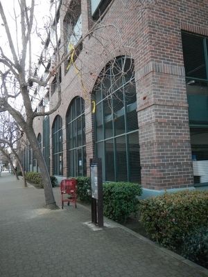
The District's Fourth Street streetscape has changed very little since 1954, the end of the
period that qualifies the District for the National Register. The later warehouses - beginning at the
northeast corner of Fourth and Harrison Streets and . . . — — Map (db m145554) HM
Two plaques are placed on Heinold's First & Last Chance Saloon. above
National Register of Historic Places
Heinolds’ First and
Last Chance Saloon
in continuous operation on this site
since 1883 and closely associated
with . . . — — Map (db m71296) HM
The building behind you was the Port of Oakland headquarters from late 1961 until 1990. An aluminum skin now covers what was a 1920s cold storage building, the Haslett Warehouse. One third of the original building was demolished to allow . . . — — Map (db m71272) HM
The Oakland Plumbing Supply Company warehouse and showroom was one of the few buildings constructed in the District during the 1920s that did not serve a wholesale grocery purpose. The company was nevertheless a significant Port of Oakland customer . . . — — Map (db m145506) HM
This is the approximate site of the first wharf authorized by the town of Oakland and constructed by Horace W. Carpenter at the foot of Main Street (now Broadway) in 1852. The wharf was used for shipping lumber and supplies. — — Map (db m71235) HM
Dedicated April 23, 1999
Jack London Square
By Port of Oakland, William Campbell Family, Dreyers Grand Ice Cream, Alameda/Oakland Ferry Service, Waterfront Plaza Hotel & Jacks, Sportsman's Hall - Pollock Pines Pony Express Home . . . — — Map (db m19017) HM
In 1985, this warehouse was renamed "The Egghouse” after the building's first use as an
egg distribution center for Poultry Producers of Central California. Poultry Producers originated the
Nulaid® brand name, a brand employed today to market egg . . . — — Map (db m145511) HM
After leaving its leased location at 255 Third St. and constructing this warehouse, S&W Fine
Foods, Inc. adopted the name that is today one of the oldest food brands in the United States. S&W grew
to become one of the country's largest packagers . . . — — Map (db m146200) HM
Sirloin steak sold for 20 cents a pound when Safeway Stores established its first headquarters in this warehouse. An adjacent Western Pacific Railroad spur line and nearby Port of Oakland shipping
facilities allowed Safeway to receive inventory and . . . — — Map (db m146199) HM
The Port of Oakland was formed on November 10, 1925 when citizen passed bonds for the development of port facilities. On February 12, 1927, the first permanent Board of Port Commissioners was sworn in by Mayor John L. Davie, The Port’s headquarters . . . — — Map (db m71270) HM
"United We Buy ... Individually We Sell” was the marketing tag line of United Grocers, Ltd.,
a wholesale grocer that supplied 1,460 retail outlets in northern California and Nevada and posted $1 billion in annual sales by the time it was purchased . . . — — Map (db m145499) HM
The West Coast's largest and oldest paint company built the District's first warehouse. W.
P. Fuller Paint Company used the warehouse to distribute paint and window glass throughout the western United States. Although the company has been sold many . . . — — Map (db m145502) HM
Western States Grocery Company roasted over 250,000 pounds of coffee a year in the
basement of this warehouse. In addition to coffee, Western States distributed a full line of grocery products. Western States competed on price (“one case or a . . . — — Map (db m145498) HM
Designer: A.W. Smith
Construction Date: 1920, Remodeled 2019
Architectural Style: Early 20th century commercial
The Autocare Sales & Service Co. showroom with a service garage was built here in 1920. Autocar’s central location . . . — — Map (db m227689) HM
Designer: W.K. Owen
Construction Date: 1923
Architectural Style: early 20th century with Beaux Arts and Arts and Crafts elements
The C. L. Greeno Company built this elaborate Pacific Coast Headquarters to receive upholstery and . . . — — Map (db m227691) HM
The District’s Fourth Street streetscape has changed very little since 1954, the beginning of the period that qualifies the District for the National Register. The later warehouses beginning at the northeast corner of Fourth and Harrison Streets and . . . — — Map (db m228118) HM
Designe: Henry H. Meyers
Construction Date: 1925-28
Architectural Style: Beaux Arts derivative/Art Deco
The Oakland Portal’s elaborate Beaux Arts façade conceals eight massive fans that draw in fresh air to the Posey Tube, an . . . — — Map (db m227915) HM
Designer: Edward A. Eames
Construction Date: 1929, Remodeled 1998
Architectural Style: Early 20th century utilitarian with Beaux Arts elements
This building was one of the few built in the District during the 1920s that did not . . . — — Map (db m227914) HM
Where Rail, Road & Water Meet
The Waterfront Warehouse District developed as an intermodal distribution hub for the post, the railroads, and the local and regional roads. Coffee, rice, sugar, produce, meat, hides, burlap bags, paper, paint, . . . — — Map (db m228137) HM
Designer: H.C. Baumann
Construction Date: 1929
Architectural Style: Early 20th century utilitarian with Art Deco elements
1926 was a profitable year for the Poultry Producers. Pooled resources created “orderly marketing” to . . . — — Map (db m228121) HM
Designer: Donald K. Olsen
Builder: Edward Smith
Construction Date: 1953, addition 1967
Architectural Style: Mid 20th century utilitarian
Built in 1953 as a restaurant and warehouse for Davidson Port Products, this warehouse . . . — — Map (db m227687) HM
Marker One:
Designer: Hugh C. White
Construction Date: 1926-27, remodeled 1994
Architectural Style: Early 20th century utilitarian with Gothic and Art Deco elements
The 1927 S&W Fine Foods warehouse was renamed Tower . . . — — Map (db m227684) HM
Designer: Couchot, Rosenwald & Roeth
Construction Date: 1929-30, remodeled 2000-01
Architectural Style: Early 20th century utilitarian with Beaux Arts elements
Sirloin steak sold for 20 cents a pound when Safeway Stores . . . — — Map (db m228134) HM
Designer: R. Vane Woods
Construction Date: 1922, remodeled 1992
Architectural Style: Early 20th century utilitarian
The Saroni family were San Francisco candy makers and sugar wholesalers who lost their home and business in the . . . — — Map (db m228119) HM
Designer: Unknown
Builder: Nick Wierh
Construction Date: 1926, replaced 2004
Architectural Style: Early 20th century utilitarian
Before condominiums were built on this corner, a large one-story warehouse housed many . . . — — Map (db m227693) HM
Designer: Walter D. Reed
Construction Date: 1914, additions 1937, 1945 & 1950
Architectural Style: Early 20th century utilitarian
W.P. Fuller paint company built and occupied the District’s first warehouse, distributing paint and . . . — — Map (db m228127) HM
Welcome to the Waterfront Warehouse District
For most of the 20th century Oakland’s Waterfront Warehouse District was a center for the collection and distribution of food products, capitalizing on Oakland’s strategic position as a center of . . . — — Map (db m228126) HM
Welcome to the Waterfront Warehouse District
For most of the 20th century Oakland’s Waterfront Warehouse District was a center for the collection and distribution of food products, capitalizing on Oakland’s strategic position as a center of . . . — — Map (db m228130) HM
Welcome to the Waterfront Warehouse District
For most of the 20th century Oakland’s Waterfront Warehouse District was a center for the collection and distribution of food products, capitalizing on Oakland’s strategic position as a center of . . . — — Map (db m228138) HM
Designer: Couchot, Rosenwald & Roeth
Construction Date: 1926, remodeled 1991
Architectural Style: Early 20th century utilitarian
Western States Grocery Company roasted over 250,000 pounds of coffee a year in the basement of this . . . — — Map (db m227692) HM
Honoring the rich musical heritage of the Blues, Jazz and Gospel artists who played on 7th Street
Come explore and learn about a glorious brea in Oakland's musical history! The music they played on 7th Street, Oakland Walk of Game pays . . . — — Map (db m92754) HM
Built in 1854, the Alviso Adobe is one of the few adobe structures remaining in the Bay Area. Declared a California Historic Landmark in 1954, the building stands relatively unmodified since the 1920s.
The adobe was in continuous use from 1854 . . . — — Map (db m24616) HM
Over time, different groups of people changed the landscape to meet their needs. The once wide open valley and its large lagoon have been transformed into smaller parcels with new uses for a growing population. Today’s seven acre park is a vestige . . . — — Map (db m217071) HM
Here stands one the first commercial buildings in Pleasanton, possibly as old as 1864. Originally a general store, this building has been a bar, brothel, bank and unofficial Wells Fargo stagecoach stop. Since 1959 it has become well-known as the . . . — — Map (db m211819) HM
Site of the Pleasanton Cheese Factory
1920 - 1987
George Spiliotopoulos
1940 - 1985
George Spiliotopoulos
"Forever a friend of Pleasanton and all
that have called it home.
Passion, pride and community." — — Map (db m193944) HM
In 1864, five years before the first railroad arrived in Pleasanton, John W. Kottinger demonstrated his faith in Pleasanton”s future by building the communities first hotel, The Farmer’s Hotel.
The building was purchased by Henry in 1891 and . . . — — Map (db m24607) HM
Public outcry led Oakland councilman George Pardee, who later became Governor of California, to campaign Contra Costa Water Company for a clean reliable water system. The Hyatt filters were installed, along with pump houses and filtration basins, . . . — — Map (db m113822) HM
“Aha!” exclaimed Anthony Chabot It was spring of 1866 when he saw the raging waters of San Leandro Creek collide with Grass Valley Creek. He studied the vast surrounding watershed and determined it could nourish a reservoir year-round. He had . . . — — Map (db m71712) HM
Underneath the lake lies evidence of the dam’s construction. The steps on this panel and the next one show how hands and hooves toiled to complete this engineering feat in 1892.
The rest of this marker consists of three illustrations . . . — — Map (db m71734) HM
Hydraulicing:
Hydraulics were used to widen and strengthen the dam. In this sketch drawn by John Muir in 1888, look for the metal-lined wooden flume into which workmen shoveled and sprayed earth from nearby hills that gravity would move . . . — — Map (db m71733) HM
The stone structure before you is a 157 foot vertical control shaft. It joins to Tunnel No. 1 to open and close the flow of water running through the tunnel pipes. Two known accidents took place at this site. Tunnel No. 1 collapsed on two Chinese . . . — — Map (db m71908) HM
The giant drums in front of you were designed and built in 1888 as part of the filtration plant that processed water from Lake Chabot. Water was forced through these sand filters to remove impurities. Named after the engineer who designed them, . . . — — Map (db m71649) HM
In February 1874 a large Chinese work force entered this woodland setting to begin construction of San Leandro Reservoir. Later renamed Lake Chabot after its French-Canadian originator Anthony Chabot, the dam was built using techniques Chabot . . . — — Map (db m71648) HM
The Alameda County Historical Society dedicates this panel to:
Ah Bing – 41, Kim Yuen – 29, Toy Sing – 31, and Lock Sing – 33, who died outside this tunnel. This panel is also dedicated to the countless unnamed and unsung Chinese laborers . . . — — Map (db m71651) HM
Oysters were the mainstay of the California fishing industry at the turn of the century. Along this site (the original Mulford Canal) the San Leandro oyster beds flourished. In 1892 William Roberts field title to the beds south along San Lorenzo . . . — — Map (db m100559) HM
The Best Building is a significant example of commercial architecture in San Leandro and the only San Leandro Plaza building remaining from the early decades of the 20th century. As a manufacturer and inventor, Daniel Best had already contributed . . . — — Map (db m54740) HM
This home was built in the late 1870’s by Joseph Demont, a San Leandro pioneer who was active in industry and politics. Daniel Best bought the property in 1886. Best established Daniel Best Agricultural Works, which later became Caterpillar . . . — — Map (db m26380) HM
West side of marker:
San Leandro’s first industries served the needs of farmers. In 1886, Daniel Best bought San Leandro Plow and formed Daniel Best Agriculture Works to manufacture tractors, combines, and harvesters. Best’s son . . . — — Map (db m26437) HM
The factory was built in 1870 by E. H. Dyer, “Father of the American Beet Sugar Industry.” Located on a corner of Dyer’s farm, the small factory began processing sugarbeets on November 15, 1870, and produced 293 tons of sugar during its . . . — — Map (db m100556) HM
This building was designed by Frederic J. DeLongchamp, a designer and engineer of mining, born in Reno, Nevada, on June 2, 1882 and educated in Nevada. He designed 500 buildings, libraries, hotels, and post offices in the counties of the State of . . . — — Map (db m635) HM
The construction of this historical complex was initiated in 1964, "Alpine County's Centennial Year", by the Historical Society of Alpine County. With concerted effort and fortitude it was completed and duly dedicated as a historical landmark on . . . — — Map (db m3088) HM
Originally built in 1862 as the Fiske House in Silver Mountain City. It was dismantled, board by board, in 1886 by A.M. Grover and a crew of men. Each board was marked and many of the old square nails were saved. It was re-erected on this site and . . . — — Map (db m20631) HM
Markleeville had few amenities during its rollicking youth, though like most respectable
pioneer towns, it boasted a hurdy house. These establishments provided the predominantly
male population a chance to unwind with a drink and possibly . . . — — Map (db m169617) HM
The mine was first worked as the Rancheria Mine in 1853. Was renamed the South Mayflower in 1893. It was organized in 1899 as the Bunker Hill Consolidated Mine and operated till 1922, producing $5,154,382 in gold. The shaft reached 3440’ on an . . . — — Map (db m44619) HM
Present two story brick structure was completed in 1879. Designed as a mercantile store, then converted to hotel and boarding house to accommodate local miners and travelers. Remained in operation until 1927. Walls at the base are twelve bricks . . . — — Map (db m9005) HM
Founded in 1851 from many claims. One of the most profitable and longest running mines. Joining with South Spring Hill Mine working till 1942. East shaft worked until 1952. Reached a depth of 2680'. Employed 100 men and produced $24,000,000 in gold. — — Map (db m26037) HM
Opened in 1852 from six claims. Renamed Original Amador Consolidated working till 1918. Reopened in 1935 till 1937. Shaft reached 1238’. Total production was $3,500,000. — — Map (db m10329) HM
Founded in 1851 working continuously till 1893. Purchased by Keystone Company in 1920 and connected to it. Closed in 1942. Contained 3 shafts: South Spring Hill 1200’, Tallisman 600’, and Medean at 600’ deep. Produced $1,092,472 from . . . — — Map (db m44608) HM
Owned by the Treasure Mining Company of San Francisco. Founded prior to 1867. Sometimes called the Hazard Mine. Shaft reached 3030’ on the incline with winzes. Was connected to the Bunker Hill Mine to the south at the 1600; level. Produced . . . — — Map (db m44620) HM
Founded prior to 1867 as the Loyal Lode Mine. The Fremont-Gover Company formed in 1872 and worked the Gover in the 1880’s and ‘90’s. The Fremont shaft was sunk in 1903 including a 40 stamp mill continuing in operation until 1918. Reopened in 1937 . . . — — Map (db m8433) HM
This plaque is dedicated on September 10, 1960 by the ancient and honorable society of E Clampus Vitus to honor the memory of the early miners, both placer and quartz, of Amador County on the Mother Lode in California.
It marks the place where . . . — — Map (db m10851) HM
Built in the 1860’s of Ione Brick by Brewers Raab and Huttner. Served as a Brewery for Over 30 Years. In 1907 C.C. Prouty Moved His Creamery to this Site. A Soda Works and Ice Plant Were Installed in 1910. Various Businesses Have Occupied the . . . — — Map (db m15825) HM
The building before you was originally built in 1856 as the two-story Williams Hotel. In 1875, Mr.
E.A. Kingsley purchased the hotel for $2,000 and renamed it The Veranda. A spectacular kitchen fire
in January of 1884 claimed the hotel, adjoining . . . — — Map (db m193575) HM
Argonaut Mine, discovered 1850, and Kennedy Mine, discovered 1856, played dramatic roles in the economic development of California. They produced $105,268,760 in gold. Kennedy Mine has a vertical shaft of 5,912 feet, the deepest in the United . . . — — Map (db m100586) HM
On the hill to your right stand the remains of the Argonaut Mine gallus (headframe), beneath which 47 miners were lost when a fire broke out deep in the main shaft on August 27, 1922. At that time the Argonaut was one of the deepest gold mines in . . . — — Map (db m94781) HM
In 1848, was a village of huts and tents called
"Bottileas”
by the Mexicans from the bottles strewn about by those who tarried here.
In 1849, it was named
Jackson
for Colonel Jackson an early day resident.
In 1853, Amador . . . — — Map (db m72060) HM
Viewpoint: 50 yards west, Two of the richest gold mines in Amador County, both reached depths of over one mile. Worked until 1942. Kennedy produced $28.5 million, the Argonaut $ 25 million. Notice headframes west toward Highway 49 and tailing wheels . . . — — Map (db m44586) HM
Gold changed an entire way of life in California during the Gold Rush. In 1860 Andrew Kennedy and three partners filed 4 mining claims of about 600 feet long. Two shafts were started near what is now Highway 49. The shafts were started, which . . . — — Map (db m101351) HM
The first major environmental project of mother lode mining. Entered on the National Historical Register July 7, 1981, through the efforts of Clyde Berriman on behalf of the City of Jackson. — — Map (db m71568) HM
In the late 1850’s, Andrew Kennedy discovered gold in an outcropping of quartz. The mine produced over $34.2 million in gold, making it one of the richest gold mines in the world. With a depth of 5,912 feet, it was the deepest mine in North America . . . — — Map (db m19797) HM
The Massa Tunnel was dug in the 1850’s on Massa Brothers' land. The tunnel extends 126’ into the east vein of the Mother Lode. Little gold was found. The Kennedy Mine acquired the property in 1898. It and the Argonaut mined the richer west vein . . . — — Map (db m44587) HM
Founded and active in the 1880’s. 10 stamp mill and a 640’ shaft. Re-opened 1921 till 1929. 20 stamp mill and a 2,291’ incline shaft. Tailing dam north to Raley’s. Produced $564,624 in gold.
Nearby Mines: South Jackson, Fern, Kearsling, . . . — — Map (db m44582) HM
- The Kennedy Mine -
You are standing on property that once belonged to the Kennedy Mine. The Kennedy Mine is named for Andrew Kennedy, who reportedly discovered a quartz ledge in the late 1850s. The Kennedy Mining Company was formed in 1860 . . . — — Map (db m72070) HM
Known as the National Hotel from 1913 to 1962, this hostelry is built over double springs at which earlier gold seekers stopped to refresh themselves. It has been in constant operation since 1862 and has served as a focal point for “community . . . — — Map (db m27670) HM
The Foothill Station became the first University of California qualifying outlying station funded jointly by federal, state and local county sources in March 1888. The station was developed under the patronage of Senator A. Caminetti of Jackson. . . . — — Map (db m72065) HM
Prominent in the mining world through his work at the Zeile, Kennedy, Argonaut & other Mother Lode mines, 1881 – 1929. His public spirit and mechanical skills led to many improvements in Jackson’s streets and bridges.
First Mayor of . . . — — Map (db m27978) HM
Dedicated to the pioneers
of California by the
Kit Carson Mountain Men
of Jackson, Amador County
June 18, 1949
An estimated $100,000,000 in
gold was handled
by this office.
Plaque provided by
Wells Fargo Bank
&
Union Trust . . . — — Map (db m27859) HM
First structure on site built in 1851. Bar portion of building erected in 1856 as drug store. Wells Fargo Express Agency moved to store briefly in 1887. Two story section built in 1858, used as a general store. Easterly one story section built in . . . — — Map (db m27857) HM
Founded in the 1860’s as the Coney Mine, operated continuously from 1875-1914. Later sold to Kennedy. Incline shaft 1865’ deep. Total production $5 million. Note powder house on road to the east. — — Map (db m44585) HM
Since 1850
Has served Jackson Gate since
The California Gold Rush
NRHP Plaque:
Augustino Chichizola's
Store
Has been placed on the
National Register
of Historic Places
By the United States
Department of the . . . — — Map (db m33376) HM
Raymond Peter Plasse arrived 1850 in San Francisco. Mined gold at Volcano & Aqueduct. In 1853 started a trading post (now site) on Emigrant Road near Wester’s Gap. & a log cabin (now used at Silver Lake. Traded supplies & fresh livestock with . . . — — Map (db m21249) HM
Michael (“Mike”) Tovey, Wells Fargo Messenger was killed and DeWitt Clinton Radcliff, stage driver injured on this spot, June 15, 1893, by a lone bandit who attempted to hold up the regular six-horse stage on the old Ione - Jackson Stage . . . — — Map (db m41555) HM
Prospectors in 1849 traveled from the Mokelumne River through Clinton on the way to the diggins in Volcano. In the early 1850’s the camp of Clinton became a market town, supplying the placer miners of the middle and southern forks of Jackson Creek, . . . — — Map (db m100578) HM
Was a mining camp about 1852. Plymouth proper began with quartz mining when settled early by Green Aden & other hard rock miners. Town was named Plymouth, probably after nearby Plymouth Mine. Post Office established 1871. Many town fires, most . . . — — Map (db m41349) HM
D’Agostini Winery was started in 1856 by Adam Uhlinger, a Swiss immigrant. The original wine cellar, with walls made from rock quarried from nearby hills, hand hewn beams, and oak casks, is still in use and part of the present winery. Some original . . . — — Map (db m100585) HM
Copper mines patented 1873:
Peak Outputs: Early 1860’s, 1895-1917, 1943-1947,
Township organized 1854.
A Methodist center for many years
U.S. Postoffice: 1862-1905 — — Map (db m11361) HM
Founded in 1852 from several claims and consolidated in 1883. Sold to the Argonaut company in 1925 and closed in 1943. Empire workings reopened 1946-47. Pacific shaft 4450’ deep. Total production $13,500,000. Mines north to Cosumnes River: Aden, . . . — — Map (db m44622) HM
Dedicated to the early Shenandoah Valley pioneers & their descendants. They mined gold & produced grain, livestock, orchards & vineyards in these rolling hills. Nearby are the old school, used for 100 years, and now a social center, and the cemetery . . . — — Map (db m10639) HM
1914 This is the approximate year that this structure was rebuilt to be the Arcade Bar. During Prohibition a soda and candy shop operated for a handful of years here. In the early 1940’s the building was converted to the “Sportsman’s . . . — — Map (db m44132) HM
The Wheeler Brothers Store was founded by Lester Wheeler and his brother Verne in 1924, and was originally across the street. In 1928 they moved to this location (at left) eventually replacing the smaller store and a saloon next to it with a . . . — — Map (db m44134) HM
This hotel is a member of the State of California 100 Year Club and was opened for business in 1860. Bellotti Inn is one of oldest hotels still in continuous operation serving travelers in the State of California. The earliest hotel opened on this . . . — — Map (db m29819) HM
2800 entries matched your criteria. Entries 101 through 200 are listed above. ⊲ Previous 100 — Next 100 ⊳