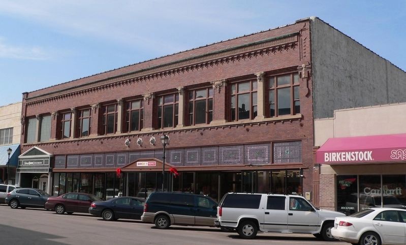
For more than 30 years after the turn of the century, the Stein Brothers Store provided quality merchandise from all over the world to south central Nebraska shoppers. Stein's buyers made regular trips to Europe purchasing goods, like Belgian lace . . . — — Map (db m187774) HM
With the establishment of the Neligh Mill and the platting of the town of Neligh, a crossing of the Elkhorn River here aided farm-to-market commerce. This bridge, built in 1910, replaced an earlier span at this location. It is a pin-connected Pratt . . . — — Map (db m158998) HM
The Neligh Mills, built from locally fired brick in 1873 by John D. Neligh, was the first business and industry in the then newly platted town. Later owners and operators of the mill included William C. Galloway, Stephen F. Gilman and J. W. Spirk. . . . — — Map (db m159000) HM
A Route and a Power Source: The Elkhorn Valley The Elkhorn Valley was a natural travel corridor into north-central and western Nebraska. Water, wood, and grass provided people and animals the critical resources to move overland wagons. Travel . . . — — Map (db m159076) HM
Water = Power The Elkhorn River was an unlimited source of water power for flour mills and other manufacturing enterprises. But entrepreneurs found the meandering river difficult to harness. Too much water was as bad as too little. The key to . . . — — Map (db m158999) HM
For more than ten thousand years the Beaver Valley and surrounding prairie, with their abundant water and wildlife, nurtured Native Americans. The Pawnee Indians, whose permanent earthlodge villages were a few miles to the south, claimed this area . . . — — Map (db m181373) HM
In the spring of 1942 the U.S. Army selected a site one mile south of here for an airfield. The dry climate and open landscape afforded ideal flying conditions. Ample water, cheap land, and Alliance’s new power plant, new hospital, and railroad . . . — — Map (db m178807) HM
By the mid-1880s the Sandhills had become an important cattle-raising region. The extension of the Burlington and Missouri Railroad westward through the Sandhills in 1877-1888 made ranching more profitable by making more accessible eastern markets. . . . — — Map (db m178801) HM
Like many Nebraska communities, Long Pine's history is tied to railroad development. When the Fremont, Elkhorn, and Missouri Valley line arrived in 1881, Long Pine became a bustling railroad town. The Chicago & North Western Railroad (CNW) built a . . . — — Map (db m182061) HM
In the late 1880's, Kearney business leaders envisioned the city as a major manufacturing center. The Kearney Cotton Mill was among the many enterprises launched as part of this venture, which included paper, woolen, and oatmeal mills; plow and . . . — — Map (db m101852) HM
and
Bauer Sundries & Veterinary Supplies
January 1959 - October 1969
Proprietor, Frances R. Bauer
Home of Kearney's last soda fountain
In honor of
George J. and Frances R. Bauer
for their civic mindedness and years of . . . — — Map (db m58857) HM
In 1888, H. D. Watson established the historic Watson Ranch, at one time containing 8,000 acres, reaching from the fertile Platte Valley on the south to the rolling hills on the north and from downtown Kearney to a point five miles west.
. . . — — Map (db m101853) HM
This Property
is listed in the
National Register
of Historic Places
By the United States
Department of the Interior
Blake Building 305 Main Street 1883 ca
John Blake, proprietor of a local saloon, erected this building. The . . . — — Map (db m78059) HM
This Property
is listed in the
National Register
of Historic Places
By the United States
Department of the Interior
Budweiser Building 1888
Anheuser-Busch Brewing Co built for $20,000 to house a saloon and liquor business. . . . — — Map (db m78051) HM
This Property
is listed in the
National Register
of Historic Places
By the United States
Department of the Interior
Drew/Weckbach 317, 321, 325 Main Street 1881 & 1886
Joseph V. Weckbach came to Plattsmouth in 1865. After . . . — — Map (db m78056) HM
This Property
is listed in the
National Register
of Historic Places
By the United States
Department of the Interior
Excelsior Building 313 Main Street 1884
Three business owners, in succession, J.C. & R. Peterson, brothers, . . . — — Map (db m78058) HM
This Property
is listed in the
National Register
of Historic Places
By the United States
Department of the Interior
Vienna Bakery 329 Main Street 1881
Built by William Stadelman, First occupant was a bakery run by William . . . — — Map (db m78054) HM
This Property
is listed in the
National Register
of Historic Places
By the United States
Department of the Interior
Wetenkamp Building 337 Main Street 1890
Many businesses occupied this site. Among them were various stores, . . . — — Map (db m78053) HM
Champion, on the Frenchman River (Creek), is the site of probably the oldest functioning water-powered mill in Nebraska. Preliminary construction on the mill was begun in the fall of 1886. The work was completed and the mill placed in operation by . . . — — Map (db m79376) HM
On August 9, 1949, the first successful oil well in western Nebraska came in for 225 barrels of oil per day at a total depth of 4,429 feet. Marathon Oil Co. completed the discovery well, Mary Egging No.1, located four miles east and two miles . . . — — Map (db m223425) HM
On June 1, 1926, George A. Coulter completed one of the first four irrigation wells in Cheyenne County, among the earliest in western Nebraska, on his farm just south of here. He and his son, James, dug the first twenty-two feet by hand. Charles . . . — — Map (db m231142) HM
Gold was discovered in the Black Hills in August, 1874. By the spring of 1876, the Army had stopped enforcing a treaty which reserved the hills for the Sioux Indians. Miners soon began to pour into the gold regions. From 1875 to 1881, the . . . — — Map (db m231079) HM
Anselmo began as a railroad town along the Burlington and Missouri River Railroad. The Burlington needed a stop for water, coal, and switching facilities. It built a depot, and the town itself was platted in November 1886. A Lincoln Land Company . . . — — Map (db m223426) HM
Broken Bow was platted 1882 by Jesse Gandy. He donated lots to people who would build a house or establish a business. He did this to influence voters to make the new town the Custer County seat, which they did in an election that fall. The . . . — — Map (db m180947) HM
The first Etna post office (1885-1895) was located three miles to the northwest. A new post office operated 1.5 miles east until 1921. In 1907 Etna saw the opening of a school, store, and telephone exchange. The store was enlarged by Andrew . . . — — Map (db m181798) HM
From about 1846 until 1872, an Indian "trading house" occupied a site near here. Built by James Bordeaux, the trading station was once attacked and set afire by hostile Crow warriors. Fortunately, some friendly Sioux Indians came to the rescue and . . . — — Map (db m4529) HM
Employees of Lancaster P. Lupton built a trading post on the creek near here in 1841 to trade with the Sioux Indians. From 1842 until at least 1845 this post was managed by Louis B. Chartran, first for Sibille and Adams and later for Pratte & . . . — — Map (db m89344) HM
Sidney — Black Hills Trail 1875-1881 Freight wagons, stagecoaches and horsemen carried supplies, passengers mail and gold between Sydney Nebraska and the gold-mining towns in the Black Hills of South Dakota. Fort Pierre — Fort Laramie . . . — — Map (db m235932) HM
This camp, constructed to house three thousand men, received the first German prisoners of war in June 1943. Most of the soldiers were members of the Afrika Korps. The prisoners were allowed to work on farms and ranches in the area and
received a . . . — — Map (db m223434) WM
Organized May 3, 1873, when Perkins was still a part of Keith County. The southwest corner is the southwest corner section eighteen of township twelve, north, range forty-one of the 6th P.M.
Both the north and south Platte Rivers traverse . . . — — Map (db m119439) HM
Ponca, one of northeast Nebraska’s earliest communities, was platted in 1856 by Frank West and laid out by Dr. Solomon B. Stough. The town was named for the Ponca Indian tribe that inhabited the area when the first white settlers arrived. The . . . — — Map (db m206794) HM
The Union Pacific reached Fremont in 1866. The new Union Depot was erected at a cost of $50,000 and gave the approach to the city a dignified and completed appearance, with its winding gravel walks, grass and flower plots and wide frontage.
As a . . . — — Map (db m58553) HM
The Bank of Florence was chartered by the Nebraska Territorial legislature on January 18, 1856. It was located in this substantial building, constructed during the same year. Sheet steel one quarter inch thick, shipped by river steamboat from . . . — — Map (db m90468) HM
On this lot stands the old mill build during the westward migration of the Mormons. Purchased by Jacob Weber in 1860. Now owned by his descendants. — — Map (db m90461) HM
The Florence Mill, one of the earliest in Nebraska, was constructed by the Mormons at Winter Quarters during the winter of 1846-1847. Supplying both flour and lumber, the water-powered mill enabled the Mormons to cope more readily with the adverse . . . — — Map (db m90460) HM
Omaha was a rich brew of immigrants, and many brought with them a well-developed taste for hops, giving rise to a half-dozen local breweries in the late 19th century. In 1887, Anheuser-Busch of St. Louis built a distribution complex in Omaha, . . . — — Map (db m35267) HM
Omaha's first municipal swimming pool, "The New Natatorium," originated in the basement of the westernmost of these three buildings; and vestiges of it can still be seen there. The ornamental work at the building's top announces that E. Homan . . . — — Map (db m35190) HM
This monument, titled Labor, is a salute to the dedication and hard work of all those who built the grand city of Omaha. It is a tribute to the men and women who worked for and continue to forge a better life for themselves, their families . . . — — Map (db m83300) HM
You are standing at the site of the original Union Pacific Omaha Shops.
From this point a railroad was begun that would fulfill a national destiny.
Even before Union Pacific was an American icon, it was an American dream. It was a . . . — — Map (db m58038) HM
Born in Virginia in 1824, James Megeath was the eldest of 10 children. By age 20, he had become a cattle and sheep trader. Struck by gold fever, he went to Calaveras County, California, in 1851, operating a general merchantise store for three . . . — — Map (db m58234) HM
Born in 1829 in Onondaga County, New York, Mr. Woolworth graduated with high honors from Hamilton College in 1849, and took up the study of law. After two years practicing in Syracuse, New York, he determined to go west and locate in the new . . . — — Map (db m58345) HM
Born in Germany, Joseph Francis Bauman came to Omaha in the early 1860s. Like many others, he may have been escaping the wars that plagued Central Europe at that time. In 1863, with his partner John Green, he purchased a brewery from a Mr. McCombe . . . — — Map (db m58338) HM
Throughout the frontier era, the Quartermaster’s Department oversaw post construction, supply procurement and transportation. It worked closely with the Subsistence Department which purchased and assigned rations. To both agencies, Fort Omaha . . . — — Map (db m58131) HM
William Brown is credited as Omaha's founder (although not its first settler). He operated a Missouri River ferry from Council Bluffs and was a principal in the company that first developed the Omaha townsite.
Mr. Brown came west as a young man . . . — — Map (db m58275) HM
No other improvement...can
equal in utility the railroad.
Abraham Lincoln
March 9, 1832
Dedicated by the railways of Omaha
to the service, comfort and
convenience of the people — — Map (db m35264) HM
This building has carried the Baum Iron name since the company purchased and occupied the property in 1905. Baum Iron Company was established in 1857 and was originally across the street. At one time this firm was the largest wholesaler of iron . . . — — Map (db m31368) HM
The initial "B" identifies this as the headquarters for the Burlington and Missouri River Railroad, which occupied the upper floors upon completion in 1879 of the original building designed by A.R. Dufrene. Nave, McCord & Brady, wholesale grocers, . . . — — Map (db m229143) HM
Omaha capitalist Ezra Millard, a former mayor of Omaha and the man for whom a western suburb was named, erected the four-story Millard Block in 1880-81. The first tenants were Tootle, Maul & Co., wholesale dry goods; Reed, Jones & Co., boots and . . . — — Map (db m35273) HM
Architects Findley and Shields designed this five-story brick, built in 1892-93 for $40,000. Footwear wholesalers W.V. Morse & Co. and Charles A. Coe and Company combined to manufacture a thousand shoes daily here, with sales focused on the western . . . — — Map (db m35266) HM
In 1903, George Fisher and Harry Lawrie designed Fire Substation No. 1 in the then-popular Chateauesque style. The gabled third floor gave the building the look of a French chateau. On April 9, 1917, firefighters were sunning themselves out front . . . — — Map (db m35244) HM
The Windsor Hotel, designed in the Italianate style, was constructed in two phases – the east wing was completed in 1885, and an addition to the west was finished by 1887. It was designed to be a workingman’s hotel, and with the proximity to . . . — — Map (db m35254) HM
After the slaughter of the buffalo and the last of the Indian hunts, ranchers moved into this part of the Republican River country in 1875. Among them were I.P and Ira Olive, who were using this canyon on their range in 1876. Herds of Texas cattle . . . — — Map (db m79219) HM
The Fairmont Creamery Company was incorporated March 29, 1884, as a stock company by Wallace Wheeler and Joseph H. Rushton. This building was the original office and the creamery was half a mile east of town. From a small, part-time business, the . . . — — Map (db m78008) HM
Look around you. The impact of the Homestead Act is clearly visible. Grain elevators, fertilizer plants, housing developments, state highways, modern farms – these and other features are tangible evidence of the Homestead Act’s success in . . . — — Map (db m47518) HM
Barbed wire proved invaluable for marking boundaries on the open prairie. Soon after its invention in 1874 there were over 570 different patents and thousands of variations. You can examine dozens of them on the fence nearby.
Why so many? Early . . . — — Map (db m47523) HM
Many Heritage Highway communities began as river settlements. Beatrice was founded in 1857 near the bend of the Big Blue River. The first building, known as Pap Towle's cabin, was constructed just north of the present Gage County Historical Society . . . — — Map (db m47627) HM
In Beatrice, industries pooled resources to obtain defense contracts by creating Homestead Industries, Inc. This "war production pool of industries" included Dempster Industries, Store Kraft Manufacturing, W.M. Haith Tank Works, Beatrice Steel . . . — — Map (db m48270) HM
The fertile North Loup Valley provided food and construction materials for the early settlers of this region. When they came here in 1872 they were greeted by Jack Swearengen, a trapper, guide, and government scout. He lived near here in a dugout in . . . — — Map (db m77914) HM
This building has been placed on the National Register of Historic Places of the United States Department of the Interior. Orginally constructed to be part of the American Hotel chain for the Bankers Realty Investment Company of Omaha, the . . . — — Map (db m53251) HM
The Early Years 1875-1881 Welcome to Atkinson — a city of 1,462 as of 2019 census and thank you for visiting Railroad Park. The Railroad played an important role in establishing our city. This picnic pavilion is on the west end of . . . — — Map (db m191594) HM
When the Burlington & Missouri River Railroad (now the Burlington Northern-Santa Fe) reached this point in 1887, it built a siding named Hecla after a volcano in Iceland. A post office was established the same year, and construction of stockyards . . . — — Map (db m180869) HM
The availability of suitable building material was of great importance to Nebraska’s pioneer settlers. Here in Jefferson County, native limestone was used for building and the stone was burned in kilns to produce lime for mortar and whitewash. The . . . — — Map (db m177301) HM
Frank Zybach, farming near Strasburg, Colorado, patented a "Self-Propelled Sprinkling Irrigating Apparatus” on July 22, 1952. Mobile towers carried a pipeline in a circle around a pivot. Sprinklers on the pipeline distributed the water. In 1954, . . . — — Map (db m147176) HM
The Burlington & Missouri River Railroad entered Nebraska at Plattsmouth in 1870 and built west to join the Union Pacific at Kearney Junction (now Kearney city) on September 3, 1872. The railroad bridge into Kearney was used for 104 years. It . . . — — Map (db m58980) HM
This friendly hometown mechanic embodies the spirit of the Lincoln Highway in Keith County. He commemorates a simpler, gentler time, when the attendant would pump your gas, check your oil, and wave you on your way with a smile.
Built in 1922, . . . — — Map (db m70370) HM
The Pony Express operated for only eighteen months, from April 1860 until October, 1861, delivering mail between St. Joseph, Missouri and Sacramento, California. It ceased operating when the transcontinental telegraph line was completed. During its . . . — — Map (db m50785) HM
In 1910 the Kimball Irrigation District voted to construct an irrigation system with a reservoir and two canals. The rough topography traversed by the canals required several aqueducts, which used flumes manufactured in Kimball, Nebraska, by . . . — — Map (db m178497) HM
On February 6, 1911, Ronald Wilson Reagan was born to Nelle and John Reagan in Tampico, Illinois. He attended high school in nearby Dixon and then worked his way through Eureka College. There, he studied economics and sociology, played on the . . . — — Map (db m179362) HM
Originally constructed in 1890 as the two-story Fitzgerald building, this structure received its upper floors in 1904, a very early example of a common haymarket occurrence. The upper floors were added on by Beatrice Creamery Company, the . . . — — Map (db m211304) HM
In the early 20th century, Haymarket was the
location of a half-dozen wholesale grocers, doing $4
million in trade over five states. This building
housed one of them, the H. P. Lau Company, Lau
was a German immigrant who began his . . . — — Map (db m211312) HM
Built in two stages, the first three floors and the loading docks of this warehouse were completed in 1920. The building was designed by architect Jesse B. Miller and built by Olson Construction Co., at a cost of $120,000, for the Lincoln Hide & . . . — — Map (db m211302) HM
In the early 20th century, as the saddlery industry
became mechanized, wholesalers who previously
supplied small harnessmakers moved into
manufacturing. The Harpham Brothers Company,
started in 1884, was one of three Lincoln
saddlery factories . . . — — Map (db m211315) HM
The "Haymarket" name can be traced to Lincoln’s first decade. In the capital city’s original plat of 1867, a "market square" was identified, bounded by O and P, 9th and 10th streets. It served as an open-air market for produce and livestock, as well . . . — — Map (db m159097) HM
A date-stone high on the north façade proclaims
"1901 Huber". Huber Manufacturing Company.
constructed their sturdy factory with brick
bearing walls and tall work-spaces in the era of
steam-powered farm implements. In 1905 ten of
Lincoln's . . . — — Map (db m211314) HM
About a half dozen Haymarket buildings gained added
stories after their initial construction. This sturdy
warehouse is probably the district's most successful
design example of vertical addition. The fact that the
same architect, Ferdinand . . . — — Map (db m212136) HM
Lincoln Fixture Building was the last of the major Haymarket buildings designed by F. C. Fiske. It
displays clearly the contrast often seen in Haymarket
warehouses between stylish fronts and utilitarian,
plain side and rear walls. The . . . — — Map (db m212131) HM
Although known as the Lincoln Hide & Fur
Building, this structure was originally built for
the Carter Transfer & Storage Company, one of
several moving and storage companies located in
the haymarket It was constructed in 1909 at a
cost of . . . — — Map (db m212121) HM
The Old Woods Bros. Companies building was built in
1914 by Mark, George and Frank Woods, Lincoln's
preeminent land developers of the early 20th century.
It was designed by A. W. Woods (no known relation)
and was built for an estimated $8,600. . . . — — Map (db m211309) HM
The Ridnour Building was one of the last factory
warehouses built during the Haymarket District's
principal period of development. J. C. Ridnour
used the building to manufacture work clothes
and overalls and as a wholesale warehouse . . . — — Map (db m212132) HM
The previous building on the site was constructed in 1885
as the Tremont House, a hotel providing sixty-two rooms.
The establishment was a favorite of visiting theatrical
companies for its location near the Depot and its rates,
starting at . . . — — Map (db m212137) HM
Seaton & Lea Ironworks of Atchison and Topeka, Kansas, established their third branch in Lincoln in 1881, building a complex that included this three-story machine and pattern shop, plus a single story foundry, ovens and sheds to the north. The . . . — — Map (db m211300) HM
The Stacy Brothers Fruit Company warehouse, built
in 1912 at an estimated cost of $25,000 is typical of
the handsome warehouses of architect Ferdinand C.
Fiske. The long-lived Lincoln architect designed six
major warehouses in Haymarket . . . — — Map (db m212135) HM
The Veith Building ranks as Lincoln's best example of
the small shops common throughout downtown in the
1880s and '90s, and as such it is individually listed on the
National Register of Historic Places. The building
displays an abundance of . . . — — Map (db m212126) HM
Blacksmithing is the working of iron. It dates back to around 1400 B.C. and by 1000 B.C. the use of iron had spread to the point that it surpassed copper and gave its name to the Iron Age. Blacksmithing reached its golden age during the High . . . — — Map (db m191898) HM
After the completion of the Transcontinental Railroad in 1869, settlers began to establish farms and ranches all around the railroad line and they needed access to the railroad to ship their crops and cattle to market and travel to neighboring . . . — — Map (db m191900) HM
This cabin was built in 1866 by R. E. Rowland out of native cedar found in the hills south of the Platte River. As a freighter to the town of Cottonwood Springs, near Maxwell, Nebraska, Rowland needed living quarters while staying in the area. . . . — — Map (db m242017) HM
The Fredericksen House was built on the site of 315 West Third Street in North Platte, Nebraska in about 1899. It was constructed precisely to the specifications that Fred Fredrickson designed himself. The house cost $2,300 and was paid in six . . . — — Map (db m191811) HM
A general store was the Wal-Mart of the 19th Century. It supplied the local community with all the items needed for everyday living. The merchandise reflected the needs of the population, whether it was a farming community or ranching community. The . . . — — Map (db m191767) HM
This is the boyhood home of William "Bill" M. Jeffers, president of the Union Pacific Railroad from 1937-1946. Remarkably he began his career as a janitor & call boy. As president, he prepared the railroad for the coming war and was appointed by . . . — — Map (db m191890) HM
100-CA-7 class cabooses were built in Union Pacific shops in Omaha, Nebraska in 1959, numbered 25400 thru 25499. This caboose was updated in 1975 with federally approved toilets, axle-driven alternators, and other items necessary for system-wide . . . — — Map (db m191899) HM
This park developed on ground once known as the “clay pit.” John F. Flynn came to Norfolk in April 1880 to start a brick factory at this site. Flynn, Dr. Ferdinand Verges, August Pilger, and Herman Gerecke formed the Norfolk Brick and Tile Company, . . . — — Map (db m181896) HM
[side 1] Built in 1906 and remodeled in 1923, this was the home of cattleman Heber Hord until his death in 1949. Hord was the only son of Thomas Benton (T.B.) Hord, who founded a livestock feeding company based in Central City. T.B. Hord . . . — — Map (db m181600) HM
On August 29, 1854, shortly after the Kansas-Nebraska Act had opened the territory west of the Missouri River to permanent settlement, Richard Brown arrived on the site of the town which was to bear his name. Other settlers soon followed. . . . — — Map (db m177299) HM
This is the former home of Robert Valentine Muir, an early resident of Brownville. Born in Scotland in 1827, Muir came to America in 1835 and moved to Nebraska in 1856 as Treasurer for the Nebraska Settlement Company. He operated a sawmill, flour . . . — — Map (db m183305) HM
Permanent settlement in this area dates from 1846, with the establishment of old Fort Kearny on Table Creek. Nebraska City, founded in 1854, became an important depot for military and commercial freighting. Pioneer businessmen, such as S. F. . . . — — Map (db m177231) HM
Today, the Missouri River is 2315 miles in length. At Nebraska City it is 1755 miles from the headwaters in Montana and 560 miles to its mouth near St. Louis, MO. where it empties into the Mississippi River. It is North America's longest river . . . — — Map (db m66978) HM
This "ELI" Windmill was the brand name of windmills produced by the Kregel Windmill Factory of Nebraska City. Established in 1879, by George F. Kregel, the factory produced windmills up until World War II. Due to materials rationing for the war . . . — — Map (db m66213) HM
In 1888, the building was constructed by Joseph Steinauer to house his banking business. In 1898, the bank received its charter. The ownership of the bank has remained within the Steinauer family for five generations. — — Map (db m190303) HM
140 entries matched your criteria. The first 100 are listed above. The final 40 ⊳