On St. George Street, on the right when traveling north.
English
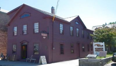
The Sinclair Inn is an important document in the history of building in Atlantic Canada. In the 1780s, tavern-keeper Frederick Sinclair created this inn by combining two existing structures. Both were frame, and the walls of one . . . — — Map (db m78701) HM
On McKeen Street north of William Street, on the right when traveling north.
English:
Having demonstrated the feasibility of transatlantic wireless communication in 1901, Guglielmo Marconi established a permanent station on Cape Breton Island in 1902. When the original Table Head site proved too . . . — — Map (db m139300) HM
English:
These are the remains of a two and a half storey masonry house built in the late 1730s for merchant and militia captain Julien Fizel and his wife Françoise Tetard.
The house served several purposes: the basement was used as . . . — — Map (db m142961) HM
On Main Street (Nova Scotia Route 22) close to Huntington Avenue, on the left when traveling north.
Cape Breton’s mining industry dictated the need of an outlet in Louisbourg to link the various railways around Sydney with Louisbourg’s ice-free harbour, allowing for year-round shipping of coal. The first attempt in 1873 was a narrow, poorly . . . — — Map (db m142965) HM
On Havenside Road, on the left when traveling east.
English: Between 15 May and 15 July the ocean in front of you is dotted with the buoys of the lobster fishery. The Mi’kmaq as well as the French and the English ate lobster and other shellfish during the 18th Century. During the 1754 siege . . . — — Map (db m79941) HM
Near Ellsworth Avenue (Nova Scotia Route 28) at James Street, on the right when traveling east.
The Anderton Shearer-Loader was a widely used coal cutter loader in which the ordinary jib of the longwall coal cutter was replaced by a shear drum capable of cutting a "web" of variable depth. The machine traveled on an armored conveyor and . . . — — Map (db m151727) HM
Near Ellsworth Avenue (Nova Scotia Route 28) at James Street, on the right when traveling east.
The armoured face conveyor (AFC) is a very large and robust piece of coal mining equipment that was installed along the full length of an underground longwall face. The coal cutting machine or shearer rode on top of the AFC where it deposited cut . . . — — Map (db m151729) HM
Near Ellsworth Avenue (Nova Scotia Route 28) at James Street, on the right when traveling east.
2 leg x 510 tonne yield hydraulically powered longwall roof support. These longwall roof supports were the last set purchased and were used underground at Prince Colliery. Each support was 5 feet wide, weighed 13 tonnes, and had a height range of 48 . . . — — Map (db m151728) HM
On Plummer Avenue east of Baker Avenue, on the right when traveling east.
Erected to the memory of those killed in explosion in No. 12 Colliery New Waterford July 25th 1917
Gaeton Angelo Aged 24
Yrs. • Frank Pancryk Aged 32
Yrs. • Constantino Boa Aged 22
Yrs. • Isaac Boone Aged 38
Yrs. • George Butt Aged 26 . . . — — Map (db m151635) HM
On Plummer Avenue, 0.03 kilometers east of Baker Avenue, on the right when traveling east.
(panel 1) In March of 1925, the members of District 26, United Mine Workers of America (UMWA) were earning an average of $3.70 per day. The pits had worked only part time for the past twenty-four months and the miners had been through a . . . — — Map (db m151636) HM
Near Ellsworth Avenue (Nova Scotia Route 28) at James Street, on the right when traveling east.
William Davis, a miner, with the British Empire Steel Corporation (BESCO), was employed at the No. 12 Colliery, New Waterford. In 1920, BESCO management began a targeted campaign to break the union. There were 58 strikes in the Sydney Coal Field . . . — — Map (db m151725) HM
On Marconi Trail (Nova Scotia Route 255) 0.2 kilometers south of Birch Grove Road, on the right when traveling north.
In 1861, Archibald and Company, a family-run business from North Sydney, opened the Gowrie Mine in Cow Bay. It was the most successful mining operation in Cape Breton in the 19th Century. Preliminary mining commenced at an old pit near the shore. . . . — — Map (db m144075) HM
On Long Beach Road, 1 kilometer north of Marconi Trail (Route 255), on the left when traveling north.
Français:
Deux mille pieds au sud-est de cet endroit se trouvent les vestiges de la première exploitation régulière d’une mine de charbon en Amérique, commencée par le Français en 1720. Cette industrie, modeste à son origine, est . . . — — Map (db m139292) HM
On Marconi Trail (Nova Scotia Route 255) at Breakwater Street, on the right when traveling north on Marconi Trail.
Joseph Talmage (J.T.) Irwin purchased a parcel of land in 1917 on the south side of Breakwater Street, with the intention of building an all-purpose store. He operated it for several years. At his death in 1934, his wife, Charlotte, and their . . . — — Map (db m144071) HM
On Long Beach Road north of Marconi Trail (Route 255), on the right when traveling north.
Commercial coal mining began in Port Morien in 1720 after a mine had been opened to supply The Fortress at Louisbourg. This was the first commercial coal mine in North America. After the English victory at Louisbourg in 1758, the mine remained in . . . — — Map (db m139293) HM
On Marconi Trail (Nova Scotia Route 255) 0.2 kilometers south of Birch Grove Road, on the right when traveling north.
The first recorded commercial fishing activity in Cow Bay occurred when the Bourinot family purchased fish, dried them, and supplied the fishermen.
Lobster factories could be found in both Port Morien and South Head. The factory owned by David . . . — — Map (db m144076) HM
Near Esplanade at Dorchester Street, on the left when traveling north.
English: "Voyage after voyage, men who had seen a dozen ships go down about them, men who had been torpedoed once, twice, three times, sailed and sailed again." —Joseph Schull, Merchant Seaman During the Second World War, . . . — — Map (db m171490) HM
On Esplanade at York Street, on the left when traveling north on Esplanade.
This statue stood on top of the Royal Bank of Canada building at the corner of Charlotte and Dorchester Streets from 1901 to 1976. The bank was erected when the Sydney Steel Plant, the major event in the industrialization of the area, was being . . . — — Map (db m171096) HM
On Victoria Road (Route 28) south of Church Street, on the right when traveling north.
English:
In the late 19th and early 20th centuries, thousands of immigrants came to Cape Breton from Europe, the West Indies, the United States, and elsewhere to work in iron and steel production. Many settled in Whitney Pier, . . . — — Map (db m139295) HM
[1.] Water turbines
the power that ran the mill
This illustration shows one type of
setup for a turbine driven gristmill.
Illustration from "the Red Mill Reborn".
Used with permission of
'Lou Robertella, . . . — — Map (db m108181) HM
You can see where some of the rock
has been removed to make a millstone
Located at Kennedy Hill, Central New Annan
Donated by Mr. William Woodlock — — Map (db m108169) HM
This turbine came from a sawmill
located a few hundred yards
upstream of our mill
The saw mill was built ca 1886 by brothers James and Alexander Sutherland. Another brother Robert, built a blacksmith shop on the same property. The mill . . . — — Map (db m108182) HM
Turbines began to become commonplace in the mid-1800's and had virtually replaced vertical waterwheels by the mid 1860's.
Below are a number of illustrations showing typical mill setups and power transfer.
In 1881 the Schoellkopf Power Station . . . — — Map (db m108183) HM
On Prince Street just east of Louise Street, on the right when traveling east.
The Lumber Jack represents the exciting role Truro has played in development of forestry in Nova Scotia. Truro has always been, and still is today, a centre of forestry activity. The forest industry continues to be the backbone of the local and . . . — — Map (db m108243) HM
A Manufacturing Town
All major roads and rail-lines run through Amherst, making it a natural gateway into Nova Scotia. The town is also in the middle of a rich agricultural and coal-mining area.
Amherst became a major manufacturing town in . . . — — Map (db m112104) HM
On Sunrise Trail (Nova Scotia Route 6) just east of Kerrs Mill Road, on the right when traveling east.
Bill was from Wallace, where his grandfather worked in the quarry and kept the lighthouse. His father was the village doctor until their move to the backwoods of northern Quebec. While there, Bill was home schooled by his mother until age 14, when . . . — — Map (db m108089) HM
On Durham Street at Water Street, on the left when traveling west on Durham Street.
Pugwash sits on top the largest salt deposit in Atlantic Canada. The train tracks, bridges, and wharves that defined the tapestry of the village infrastructure changed significantly over the decades as local industry evolved, including the . . . — — Map (db m108068) HM
On Water Street at Victoria Street, on the left when traveling north on Water Street.
While lobster boats have filled the local wharves for generations, the community's most unique feature may have been the 130 ft. (39.6m) smoke stack belonging to Nova Scotia Clayworks on the opposite side of the harbour. Started in 1889, the . . . — — Map (db m108078) HM
On Water Street at Victoria Street, on the left when traveling north on Water Street.
The deep harbour of Pugwash has a long and storied seafaring heritage, with many eras of ships carrying lumber and raw materials up and down the Eastern Seaboard.
[Historic Pugwash photos]
"Peace cannot be kept by force; it can only be . . . — — Map (db m108080) HM
On School Street, on the right when traveling east.
Important as a centre for the North Atlantic fisheries from
the 16th century, the islands in Canso Harbour offered a
safe haven for fishermen. First frequented by the French
and Basques, the area became the site of an extensive . . . — — Map (db m138598) HM
Fishermen sailed to this coast before the earliest explorers. In the early 1600s French and Basque fishermen dropped handlines in the waters.
By 1725 New Englanders were pulling in cod worth 150,000 pounds (New England currency) . . . — — Map (db m140554) HM
On Marine Drive (Nova Scotia Route 316) at Port Felix Loop, on the left when traveling west on Marine Drive.
Every summer for more than 40 years,
beginning in 1565, this Basque fisherman
from Saint-Jean-de-Euz sailed to Eskikewa'kik,
a district of Mi’kma’ki within the traditional
territory of the Mi'kmaq. Here, his crew
caught codfish, which . . . — — Map (db m138605) HM
On Marine Street (Nova Scotia Route 316) at Port Felix Loop, on the left when traveling west on Marine Street.
Welcome to Place Savalette This park has been developed to mark and explain the site of the historic 1607 meeting between Basque fisherman/entrepreneur, Captain Savalette and explorer/cartographer Samuel de Champlain
on the shores . . . — — Map (db m139825) HM
On Marine Drive (Nova Scotia Route 16), on the left when traveling east.
A Community linked to the Sea
Queensport was a fishing village community long before the first European settlers arrived here in the 1700s. Each spring and summer, the aboriginal Mi’kmaq would gather to harvest fish, one of the most . . . — — Map (db m141232) HM
Near Granville Street north of Duke Street, in the median.
English:
This building, erected in 1860, provides a rare and early example of a full cast iron facade in Canada. Used in construction since the 1770s, cast iron had become a popular decorative material by the mid-19th century . . . — — Map (db m139596) HM
Near Upper Water Street just north of Duke Street, on the right when traveling north.
English:
An ambitious seaman from Liverpool, N.S., and sometime privateer, Enos Collins was reputed to be the richest man in British North America when he died. His fortune, amassed through shrewd investments in mercantile, . . . — — Map (db m139664) HM
On George Street at the Waterfront, in the median on George Street.
Just inland from this place, Chebucto Landing, 2,576 first permanent settlers of Halifax came ashore from thirteen small ships in June 1749. Here, you are at the shore of one of the great natural harbours of the world, the focus of Halifax's . . . — — Map (db m113185) HM
Izaak Walton Killam, born in Yarmouth, N.S. in 1885, was the leading Canadian business person of the first half of the 20th Century. His Royal Securities Corporation owned, controlled or financed many of Canada's major companies, mainly in pulp . . . — — Map (db m113081) HM
National Historic
Civil Engineering Site
Ocean Terminals
1912-1928
A tribute to the civil engineers
and contractors who designed and built these
ocean terminals Canadian Society for
Civil Engineering June 1998
Site historique . . . — — Map (db m139330) HM
English: The Port of Halifax is one of the world’s finest natural harbours. Ice-free year-round, its main channel depth of over 18 metres (60 feet) offers shippers some of the deepest and most navigable waters along the North American . . . — — Map (db m140099) HM
A native son and a great Nova Scotian, he received his early training in this city and became a highly regarded merchant, humanitarian and ship owner. All this was a prelude to his most successful venture, the founding of the British and North . . . — — Map (db m77879) HM
On Marginal Road east of Lower Water Street, on the right when traveling north.
English: Samuel Cunard was born in Halifax, Nova Scotia on November 21, 1787. He was the eldest son of Abraham and Margaret Cunard, United Empire Loyalists who emigrated from Philadelphia (Germantown) to Nova Scotia in 1783. His . . . — — Map (db m139200) HM
On Ta39 Road, 0.3 kilometers south of Point Pleasant Drive when traveling south.
English: Born in Halifax of Loyalist parentage, Cunard founded in the maritime provinces a commercial empire embracing banking, lumber, land, coal and, especially, shipping. Involved in transatlantic steam navigation from its early . . . — — Map (db m139202) HM
Near Castine Way at Lord Dalhousie Drive, on the right when traveling east.
English:
A native of Kings County, Chase made his fortune as a shipper of potatoes and apples, warehouse developer and speculator in Annapolis Valley fruits. Active in the Nova Scotia Fruit Grower’s Association, he initiated apple . . . — — Map (db m141002) HM
On Peggy's Point Road, 0.4 kilometers south of Prospect Road (Nova Scotia Route 333), on the left when traveling south.
Before Peggy's Cove was a community, it was a popular destination among fishermen. But what inspired these fishermen to make this their permanent home? It was this sheltered cove, which offered close proximity to the large populations of fish in . . . — — Map (db m112570) HM
On Marine Drive (Nova Scotia Trunk Highway 7), 0.1 kilometers west of Church Point Road, on the left when traveling west.
Following the expulsion of the Acadians in 1755, the Government of Nova Scotia distributed grants of land, in an effort to populate the province with British subjects.
Prior to white settlement, Sheet Harbour served as a summer hunting . . . — — Map (db m146114) HM
On Marine Drive (Nova Scotia Trunk Highway 7), 0.1 kilometers west of Church Point Road, on the left when traveling west.
For almost 150 years, the East and West Rivers provided Sheet Harbour with waterpower for its sawmills. In the 1920s, the East River played an important role in delivering hydroelectric power to Sheet Harbour, as well as other communities in Nova . . . — — Map (db m146158) HM
Near Marine Drive (Nova Scotia Trunk Highway 7), 0.3 kilometers east of Highway 224, on the right when traveling east.
Situated on the Eastern Shore of Nova Scotia, Sheet Harbour lies at the junction of the East and West Rivers. This forested area, with its excellent river systems and natural port, proved ideal for the establishment of a prosperous lumber . . . — — Map (db m146119) HM
Near Marine Drive (Nova Scotia Trunk Highway 7), 0.3 kilometers east of Highway 224, on the right when traveling east.
For centuries, salmon fishing on Sheet Harbour’s East and West Rivers was both a livelihood and leisure activity.
The Mi’kmaq were the first to utilize this rich resource, while Loyalist settlers and their descendents fished salmon for . . . — — Map (db m146120) HM
Near Marine Drive (Nova Scotia Trunk Highway 7), 0.3 kilometers east of Highway 224, on the right when traveling east.
First settled in the 1780's by British veterans and Loyalist refugees from the American Revolution, Sheet Harbour is an important centre on Nova Scotia's eastern shore. West and East Rivers meet near here, and where their waters tumble and froth . . . — — Map (db m146113) HM
On Marine Drive (Nova Scotia Trunk Highway 7), 0.1 kilometers west of Church Point Road, on the left when traveling west.
With few existing roads along the Eastern Shore in the eighteenth century, the only reliable route to Halifax was by sea. During this period, Sheet Harbour’s isolated inhabitants relied on boats and ships for fishing, trade, and travel along the . . . — — Map (db m146116) HM
Near Marine Drive (Nova Scotia Trunk Highway 7), 0.3 kilometers east of Highway 224, on the right when traveling east.
Following the expulsion of the Acadians in 1755, the Government of Nova Scotia distributed grants of land in an effort to populate the province with British subjects.
Located 75 miles (115 km) east of Halifax, on Highway 7, the . . . — — Map (db m146118) HM
Near Marine Drive (Nova Scotia Trunk Highway 7), 0.3 kilometers east of Highway 224, on the right when traveling east.
As Sheet Harbour's lumber industry prospered in the nineteenth century, there was a growing demand for ground wood pulp, which was used in the manufacture of paper products such as newsprint.
Local lumber baron William Chisholm . . . — — Map (db m146117) HM
On Jennings Settlement Road at James Mason Lane, on the left when traveling west on Jennings Settlement Road.
English: Prince Alfred (1844-1900), second son of Queen Victoria, visited Tangier on October 19, 1861, arriving by boat, here in Mason's Cove. The prince and his party of dignitaries were welcomed by the Government Superintendent, . . . — — Map (db m150295) HM
Near Cabot Trail just north of Barren Road, on the left when traveling north.
Français:
Dés l'année suivante, en 1927, M. J. Macfarland engage M. A. Boudreau à temps plein comme directeur-adjoint des opérations à Chéticamp. M. Boudreau s'occupe particulièrement de la comptabilité de la compagnie, . . . — — Map (db m139698) HM
Near Cabot Trail just north of Barren Road, on the left when traveling north.
Français:
Cette bouée ancrée dans le havre de Chéticamp permettait aux grands transatlantiques de tourner sur eux-mêmes. Elle avait été entièrement attachée avec des rivets chauds. Elle servit de 1928 à 1946.
. . . — — Map (db m139797) HM
Near Cabot Trail just north of Barren Road, on the left when traveling north.
Français:
La guerre met cependant fin aux opérations quand l'Angleterre réquisitionne les bateaux pour le ravitaillement des troupes. La dernière cargaison pour l'Angleterre fut déchargée en mer pour permettre au bateau de se . . . — — Map (db m139734) HM
Near Cabot Trail just north of Barren Road, on the left when traveling north.
Français:
Après plusieurs vaines tentatives de ressusciter l'entreprise, ce n'est qu'en 1926 que l'Atlantic Gypsum Company de Boston achète toutes les installations et engage M. Joseph MacFarland pour relancer l'exploitation de la . . . — — Map (db m139697) HM
On Cabot Trail just north of Barren Road, on the left when traveling north.
Father Pierre Fiset, Chéticamp parish priest, is generally recognized as being responsible
for starting the gypsum mine in Chéticamp in 1907. When news broke that a prospector named Grandin had found gypsum in Chéticamp, Father Fiset . . . — — Map (db m139335) HM
Near Cabot Trail just north of Barren Road, on the left when traveling north.
Français:
On creuse un tunnel de l'entrepôt jusqu'à la mer, passant sous le chemin ; on construit un long quai recouvert dans lequel on achemine le gypse par convoyeur. Tous les travaux sont terminés en 1929, et au mois de juin de . . . — — Map (db m139696) HM
Near Cabot Trail just north of Barren Road, on the left when traveling north.
Français: Les affaires vont bien, on décide d'agrandir. Après le décès du Père Fiset, on emprunte 100,000$ pour construire une voie ferrée entre la carrière et le quai des Fiset. On achète une locomotive à vapeur avec dix wagons de . . . — — Map (db m139695) HM
Near Trans Canada Highway (National Route 104) 0.5 kilometers west of Ceilidh Trail (Route 19), on the right when traveling west.
Making a Living in the Strait of Canso Area since 1784.
Transportation and Communication Early Years: Stage Coach Lines, Ferries, Mail Service Link, Telegraph Offices, American Consular Offices, Railroads, Boston Boats and Coastal . . . — — Map (db m139296) HM
Near Trans Canada Highway (National Route 104) 0.5 kilometers west of Ceilidh Trail (Route 19), on the right when traveling west.
English:
The Strait of Canso separates Cape Breton Island from the mainland of Nova Scotia. The Mi'kmaq were the original settlers in the area until the 1780's, when other settlements were established on both shores. Historically, . . . — — Map (db m139299) HM
On King Street (Nova Scotia Route 3) at the Old Bridge Street bridge over the LaHave River (Nova Scotia Route 3), on the right when traveling north on King Street.
Up in Flames
In the cold, early hours of January 12, 1899, a fire began in the basement store of E. B. Simonson, located in the Music Hall at the corner of Dominion Street, and Commercial (now King) Street, where you are . . . — — Map (db m112426) HM
On Bluenose Drive close to King Street, on the right when traveling west.
English
Seafaring of all kinds, and fishing especially, is one of most dangerous occupations. Lunenburgers have lived with the dangers associated with making a living from the sea. Fishermen in dories would get lost in the fog, unable to . . . — — Map (db m78204) HM
On Bluenose Drive close to King Street, on the right when traveling west.
English
By 1870, Lunenburg schooners abandoned the Labrador fishery and concentrated on the fishing banks off of Nova Scotia and Newfoundland. Instead of handlining from the schooner’s deck, fishermen set out in dories - double-ended, flat . . . — — Map (db m78207) HM
On Bluenose Drive close to King Street, on the right when traveling west.
English
Although efforts were made to use large vessels known as otter trawls in the offshore fishery in the 1920’s, they were not used extensively until after the Second World War. Unlike the long line which used baited hooks to attract . . . — — Map (db m78206) HM
On Bluenose Drive close to Cornwallis Street, on the right when traveling west.
English
Lunenburg’s early settlers, the “Foreign Protestants,” came from a rich agricultural area in Europe and it was planned that they should establish farms which could supply both their own needs and those of the colony’s . . . — — Map (db m78259) HM
On Bluenose Drive close to Hopson Street, on the right when traveling east.
English
Lunenburg’s success in the fishery stimulated the construction of many fishing vessels. Almost all of the schooners fishing out of Lunenburg during the Town’s first 200 years were built in the Town or in other Lunenburg County . . . — — Map (db m78154) HM
Near Glasgow Street at Dalhousie Street, on the left when traveling north.
Into the East River at New Glasgow between 1821 and 1918 were launched some two hundred and ten sailing ships of 100 to 1400 tons burthen, built by native workmen from native materials.
The locally owned, commanded and manned vessels moved . . . — — Map (db m144793) HM
On North Provost Street (Nova Scotia Route 348) at George Street (Nova Scotia Route 289), on the right when traveling south on North Provost Street.
This area of Downtown New Glasgow was known as Bell's Corner for well over a century. Basil Bell (chemist, teacher and entrepreneur) constructed this architecturally sound stone home and store (to your left) in the mid 1840's. He and his wife would . . . — — Map (db m144797) HM
On Glasgow Street just south of Dalhousie Street, on the right when traveling north.
”One of New Glasgow’s most interesting and notable persons is George Rogers McKenzie. During his lifetime he was a builder of ships, deep water captain, a master mariner and a politician.” —Stories from Pictou County’s . . . — — Map (db m144795) HM
On Archimedes Street (Nova Scotia Route 4) (Nova Scotia Route 289) north of MacLean Street, on the left when traveling north.
You are standing beside the Mae MacGillivray Building, which was renovated in 2014 by MacGillivray Properties Limited. The loft apartments have an industrial theme rooted in the County's history of coal, steel and shipbuilding. A 1916 book Pictou . . . — — Map (db m144806) HM
On Glasgow Street just south of Dalhousie Street, on the right when traveling north.
The community that was to become New Glasgow was settled in 1784 by Deacon Thomas Fraser. By 1809 the Town was named after Old Glasgow in Scotland and incorporated in 1875. A strong entrepreneurial spirit was evident even in 1809 when the first . . . — — Map (db m144794) HM
On Archimedes Street (Nova Scotia Route 4) (Nova Scotia Route 289) at Dalhousie Street, on the left when traveling north on Archimedes Street (Nova Scotia Route 4).
New Glasgow is a scenic riverside town of 9,455 residents, which serves as the commercial-service centre for northern Nova Scotia with a rich multi-cultural mosaic. Founded by Scottish settlers in 1784, the town was named after Glasgow, Scotland and . . . — — Map (db m144801) HM
On Archimedes Street (Nova Scotia Route 4) (Nova Scotia Route 289) just north of Dalhousie Street, on the right when traveling north.
Mrs. Viola Irene (Davis) Desmond was born on July 6, 1914 in Halifax, Nova Scotia, to James and Gwendolyn Davis. Viola was one of 15 siblings who grew up in and around the city area. After graduating from Bloomfield High School with excellent marks, . . . — — Map (db m144798) HM
Near South Foord Street (Nova Scotia Route 374) at Union Street, on the left when traveling north.
”The Town of Stellarton always meant a lot to me” —Frank H. Sobey Stellarton Town Square was the site of the Jubilee Theatre and the first Sobeys Food Store, built in 1912 by John William Sobey to expand his meat delivery . . . — — Map (db m151321) HM
Near South Foord Street (Nova Scotia Route 374) at Union Street, on the left when traveling north.
Best known as the entrepreneur who grew his father’s small meat delivery business into a regional grocery powerhouse that has since expanded to serve millions of Canadians country-wide, Frank H. Sobey was, first and foremost, a proud Nova Scotian . . . — — Map (db m151320) HM
Near North Foord Street (Nova Scotia Route 374) 0.2 kilometers south of Trans-Canada Highway (National Route 104), on the left when traveling south.
English:
This British firm established coal mining as a major industry in Nova Scotia. Granted a monopoly of provincial mineral rights in 1826, the GMA developed coal operations here at Albion Mines and at Sydney Mines, and . . . — — Map (db m140077) HM
On Main Street (Route 348) at Forge Street, on the left when traveling north on Main Street.
From humble beginnings, two enterprising Pictou County blacksmiths, Graham Fraser and Forrest MacKay would set up a business to manufacture products for the railway and shipping industry. In the year 1878 they would move their growing company to . . . — — Map (db m150404) HM
On Main Street (Nova Scotia Route 348) at Pleasant Street, on the left when traveling north on Main Street.
This interpretive panel erected on July 11, 2019 to commemorate the designation by Trenton Town Council of this area as a Trenton Heritage Site, where the first successful commercial pouring of Steel in Canada occurred in 1883, within the Steel . . . — — Map (db m150403) HM
On Main Street (Nova Scotia Route 348) at Forge Street, on the right when traveling north on Main Street.
On September first, 1953, seventy years after the production in the open hearth plant of the Nova Scotia Steel Company Limited at Trenton, Pictou County, Nova Scotia, of the first steel ever made in Canada, this ingot, cast in 1883, erected by the . . . — — Map (db m150496) HM
On Main Street (Nova Scotia Route 348) at Pleasant Street, on the left when traveling north on Main Street.
Trenton Works axle hammer had a distinct sound when operating. People would refer to it as the "heartbeat of Pictou County", as the sound meant the plant received an order which was good news for the local economy. Trenton Works employees were noted . . . — — Map (db m150402) HM
Near Chebucto Street (Nova Scotia Route 205), on the right when traveling west.
English:
The Park commemorates the humanitarian and scientific achievements of Alexander Graham Bell (1847-1922) and his associates
Frederick W. Baldwin • John A.D. McCurdy • Glenn H. Curtiss • Thomas E. Selfridge
Most of the . . . — — Map (db m80007) HM
The Southwestern shore of Nova Scotia, including Yarmouth County, is home to one of Canada's largest fisheries. For over two hundred years, fishing boats have sailed past this point, as well as from other ports in this region, to fish groundfish, . . . — — Map (db m107638) HM
Pieces of the Past
Since 1840, a lighthouse has kept watch over Cape Forchu and the approaches of Yarmouth Harbour.
In 1962, the original lighthouse was replaced with the iconic "apple core" structure that towers over the Cape today.
The . . . — — Map (db m107551) HM
The Tusket Islands
Located south of Yarmouth, the Tusket Islands extend mainly along the coast, from Pinkney's Point to Wedgeport. The Tusket Island chain was once a great asset to the fishing economy of Nova Scotia's Southwestern . . . — — Map (db m107652) HM
On Dennis Point Road, 1 kilometer south of D'Entremont Road, on the left when traveling south.
Récolter la mer
Vous êtes debout sur l'un des quais de pêche les plus achalandés au Canada.
Autrefois, le hareng était pêché dans des parcs en fascines, ou « nijagans » inventés par les Mi'kmaq. Le poisson entrait dans le parc . . . — — Map (db m108006) HM
On Dennis Point Road, 1 kilometer south of D'Entremont Road, on the left when traveling south.
Following the fish
While Dennis Point's most valuable fishery is lobster, this wharf is also home to Canada's largest ground fishing fleet. This diverse fishery takes our fishermen (and women) to many special fishing areas.
Going the . . . — — Map (db m108001) HM
On Main Street (Nova Scotia Route 1) just south of Public Street, on the right when traveling south.
This park
named in honor of
Charles Sydney Frost, M.C.
Native son who,
through diligence
and ability, became
President of the
Bank of Nova Scotia
June 14, 1956 — — Map (db m107872) HM
On Water Street at Glebe Street, on the right when traveling north on Water Street.
Dedicated to the memory of all those
residents of Yarmouth County
and crew members of ships owned
in Yarmouth County who have been
lost to the sea
We honour those here named as well
as those not yet known to us
[Remembered Dead . . . — — Map (db m107927) HM
On Water Street at Glebe Street, on the right when traveling north on Water Street.
The year 1879 was a disastrous one for Yarmouth County, Nova Scotia, with no fewer than 31 vessels lost along with 106 persons. The ships lost were among the best of the Yarmouth fleet, some carrying valuable cargoes. The loss of life left 26 . . . — — Map (db m107934) HM
On Water Street, 0.1 kilometers south of Richards Lane, on the right when traveling south.
Early manufacturing in Yarmouth grew in support of the shipbuilding industry, the fishery, and the maintenance of vessels engaged in shipping. The flourishing textile industry had its origins in the ability to import inexpensive raw materials, . . . — — Map (db m107320) HM
On Water Street, on the right when traveling south.
The passage of the National Prohibition Act on January 16, 1920 signalled the prohibition of alcohol for general consumption in the United States and provided an opportunity for enterprising Yarmouth businessmen and seamen. Yarmouth-based . . . — — Map (db m106221) HM
On Water Street, on the right when traveling south.
The first vessel known to have been built in Yarmouth was launched by John Sollows at Fish Point in 1764. Over the years, many ships were built in nearby communities such as Argyle, Tusket, Plymouth, Salmon River, Meteghan, and Belliveau's . . . — — Map (db m106216) HM
On Main Street at Marshall Lane, on the right when traveling south on Main Street.
From its early beginnings on Cape Breton Island the shipbuilding industry grew as settlement did in the late 18th century. During the Golden Age of Sail in the 19th century, thousands of wooden vessels of all sizes were built in bays and harbours . . . — — Map (db m106067) HM
On Water Street at Lovitt Street, on the left when traveling north on Water Street.
The Age of the Passenger Steamer
With the coming of the steam engine, it was only a matter of time before the sleek lines of wooden hulls and trim masts were replaced by riveted steel plates and tall stacks. By the mid-nineteenth . . . — — Map (db m112166) HM
On Water Street, on the right when traveling south.
A cornerstone of Yarmouth's economy from its first settlement, fishing continues to the present day to be an important aspect of life in the community. Yarmouth fishermen have always pursued a diversity of species: lobsters, scallops, cod, . . . — — Map (db m106323) HM
On Water Street just north of Central Street, on the left when traveling north.
The Killam Family Built a Business
By the third quarter of the nineteenth century, many Yarmouth companies and their owners were enjoying substantial profits as a result of their investments in shipping and labours as commission . . . — — Map (db m112200) HM
On Water Street at Lovitt Street, on the left when traveling north on Water Street.
Merchants and Mariners
True to the code of merchant-mariners, Parker-Eakins & Co. saw their mission as an endeavor “to facilitate the production, distribution and exchange of goods and services for mutual profit and . . . — — Map (db m112171) HM
101 entries matched your criteria. The first 100 are listed above. The final 1 ⊳