First National Bank - 1892-1918
Day Barber Shop - 100+ years
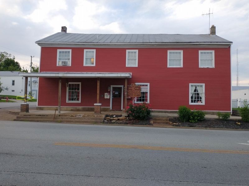
Bluffton Post Office - 1904
Hamp Swank Restaurant - circa 1919
Carter Notion Store 5¢ to 10¢ - circa 1922
Moser-Bixel Ford Floor Mats - circa 1925
Kroger Store - circa 1925 . . . — — Map (db m196221) HM
Built at the Lima Locomotive Works
Lima, Ohio
for Tioga Lumber Company
Nicholas County, West Virginia
Purchased by the Auglaize Township
Historical Society in 1996 — — Map (db m29730) HM
This caboose spent most of its working years in Lima and northwest Ohio and was renovated by the Auglaize Township Historical Society in 1994 — — Map (db m29723) HM
Allen County was originally Indian territory not opened for settlement until 1817, and was formally surveyed in 1820. County government was organized in 1831 and with the improvement of roads, settlers came and established communities in every part . . . — — Map (db m22930) HM
In honor of the company's
104 year history in Lima
is proud to donate
the Standard Oil Building
to the Lima Art Association
for use as an art center
for all the people of
the Lima area — — Map (db m196306) HM
In 1964, the Detroit, Toledo, and Ironton Railroad donated an equipped station to the Lincoln Park Railroad Exhibit. The depot behind you was moved from its original location at Uniopolis, Ohio ten miles to the south. It came complete with signal . . . — — Map (db m203819) HM
Eastman Johnson (1824-1906) is remembered as
one of the most important American painters of
the 19th century. Most of his Maple Sugar
paintings were painted between 1861-1865.
His work celebrates maple sugaring not only as a
way of life . . . — — Map (db m173789) HM
In 1885, 800 feet north of this marker, Benjamin Faurot struck oil after drilling into the Trenton Rock Limestone formation at a depth of 1,251 feet. This event marked the beginning of the great Oil Boom of northwest Ohio. The ensuing rush brought . . . — — Map (db m22931) HM
One of America's largest steam locomotive builders, the Lima Locomotive Works, built 7,752 locomotives between 1879 and 1951. It rose to success building the patented Shay geared locomotive, an innovative design that became the standard for . . . — — Map (db m22935) HM
Locomotive No. 779, built by the Lima Locomotive Works in 1949, is the last steam locomotive manufactured in Lima. As a “Berkshire-type”, it represents the most advanced development of steam power. The Nickel Plate Railroad had a total of 80 such . . . — — Map (db m203831) HM
Caboose No. 1091 was built in 1882 by the Lafayette Car Works of Lafayette, IN. It has been completely restored and equipped by the Allen County Historical Society. Although much of the structure has been replaced during its years of service, the . . . — — Map (db m29716) HM
Oil became a valuable resource in Ohio when significant quantities were discovered in Lima in 1885. The discovery brought an economic boom to Lima and northwest Ohio. News of the Lima oil field spread, attracting the attention of John D. . . . — — Map (db m22961) HM
• Originally, The Hotel Kirwan
• Built by, and named after,
Daniel Kirwan in 1928
• Architect, Peter M. Hulsken,
Lima, Ohio
• The Inn, Center Square
• Renovated and converted by
Associated Innvestors Management
in 1982
• C. R. C. . . . — — Map (db m196302) HM
In 1910, the Ohio Electric Railway Company opened this terminal, formerly the Interurban Building, which served interurban passengers until 1937. Along with offices, it contained space for express and baggage handling, ticket windows, a newsstand, . . . — — Map (db m22934) HM
This grain mill, which was located at the southwest corner of Second & Broadway Streets and considered one of the oldest landmarks in Spencerville, was constructed in 1843 and remained in existence until the early 1940's. The mill eliminated the . . . — — Map (db m196332) HM
Miami – Erie Canal
From 1845 to about 1906 barges pulled by horses provided transportation from the Ohio River to Lake Erie through a system of locks which raised or lowered boats to the next level of the canal.
Locks often became . . . — — Map (db m22933) HM
Miami & Erie Canal, Deep Cut
You are on that section of the Miami and Erie Canal where the greatest excavation was made – a section that has been known over the years as “Deep Cut.” The huge ditch, 6,600 feet long and 5 to . . . — — Map (db m22848) HM
Miami And Erie Canal Deep Cut
has been designated a
Registered National
Historic Landmark
Under the provisions of the
Historic Sites Act of August 21, 1975
this site possesses exceptional value
in commemorating or . . . — — Map (db m166567) HM
From 1845 to about 1906 barges pulled by horses provided
transportation from the Ohio river to Lake Erie through a
system of locks which raised or lowered boats to the
next level of the canal.
Locks often became sites of towns. Beginning . . . — — Map (db m166569) HM
Spencerville was platted in 1844 under the name "Spencer". In 1854, the name was changed to "Acadia", and was incorporated as Spencerville in 1866. The town was located on the banks of the Miami & Erie Canal, and its development as a commercial . . . — — Map (db m196325) HM
Canal boats carried either freight or passengers. The typical canal boat was 14 1/2 feet wide by 85 feet long and carried up to 100 tons of cargo. Each boat typically had a captain, members of his family, animal drivers, steersmen and a bowman. The . . . — — Map (db m196328) HM
Canal specifications called for the canal to be 28' wide at the bottom and 40' wide at the top. The water level was 4' deep and the tow path was 10' wide. A team of mules, donkeys or horses pulled the boat along by means of a 90 foot tow rope. — — Map (db m196329) HM
Uses along the canal have changed dramatically over time. The main use of the canal was the transporting of commerce. However, the canal ran through many towns and places where populations needed recreation and an outlet from everyday life. This . . . — — Map (db m236377) HM
The Buckeye Trail and North Country Trails are located on the towpath of the Miami- Erie Canal, between the old canal and CR-66A, it then passes through Deep Cut Park, a 6,600 foot long, 50 foot deep, cut dug by hand. The Johnny Appleseed . . . — — Map (db m236414) HM
This building was a center of community life from the time of its construction in 1886 to the late 1930s. Once common, such combinations of governmental offices and commercial and entertainment space are today rare. The second floor opera house . . . — — Map (db m24286) HM
A pioneer in automotive innovation. Charles Franklin Kettering (1876-1958) was born three miles north of Loudonville. He attended local schools and graduated from Ohio State University in 1904. He organizaed the Dayton Engineering Laboratories . . . — — Map (db m157069) HM
The place of the early mill in the community is worth noticing. They were places of assembly for the scattered inhabitants of the country, where they came not only to get their wheat and corn ground, but also to hear the news, to barter, to . . . — — Map (db m240027) HM
Today the country mill, like the horse and wagon with which it is so closely associated, is a faded page in history. It has been replaced by large commercial mills which have refinements for processing flour economically beyond the reach of the . . . — — Map (db m240025) HM
The main purpose of the smokehouse was to preserve meat, so it would last for a longer period of time. Preservation was achieved in this two-step process: 1.) The fresh cuts were packed in tubs of coarse salt for about six weeks, the salt drawing . . . — — Map (db m240035) HM
Sorghum molasses, along with maple syrup and honey were frontier sweeteners of the 1800's. Most communities had a sorghum mill that farmers brought their cane stalks for processing. There the 6-to-12 feet stalks were crushed between rollers powered . . . — — Map (db m240029) HM
Milling in Ohio began in the late 18th century. Mills were used in many industries around the state, such as grist mills used to process grain. Built in 1831, the Wolf Creek (Pine Run) Grist Mill originally stood north of Loudonville at Wolf Creek. . . . — — Map (db m240024) HM
The location of Shaffner-Knox Drugs, built for Doxsie Dairy Company
1935-1952
Doxsie Dairy Company
1957-1970
Commercial Testing and Engineering Company — — Map (db m132361) HM
Built in 1889 by A.J. Beckwith
1889-1908
A.J. Beckwith Dry Goods
1912-1927
Globe Clothiers
1930
Turner's Drug Store
1934-1940
The Great A & P Tea Company
1941-1945
England . . . — — Map (db m132359) HM
Burrill Block
The location of Edward H. Burrill Meat Market, the Burrill Block was built in 1900
1896-1921
Burrill's Meat Market
1926
Ragnvald Wary Billiards
1941-1953
Corner Restaurant . . . — — Map (db m132362) HM
Built in 1889 by John & Oliver Topky
1889-1950
Topky Brothers Hardware & Ship Chandler
1951-1978
The Topky Hardware Company
1979-1995
Topky-Cook's Hardware Company — — Map (db m132356) HM
The location of Edward H. Burrill Meat Market, the Burrill Block was built in 1900
1900-1908
H. Bieder Company, confectioner, ice cream, cigars, news dealer
1909-1962
Christiansen Confectionery Store
Upstairs . . . — — Map (db m132364) HM
The location of Cooper Butcher Shop, the Kunkle Block was built in 1900
1907-1918
F. J. Kempel Jeweler
1921
Century Club
1926-1931
Marine Sanitary Barber Shop
Wilfred Beauty Parlor
1944-1971 . . . — — Map (db m132295) HM
Built in 1889 by John & Oliver Topky
1895-1897
Mills and Burton Drugs
1898-1914
H.T. & L.T. Carlisle Department Store
1914-1927
George S. Eddy Department Store
1929-1931
John Dellerba, . . . — — Map (db m132355) HM
The location of Cooper Butcher Shop, the Kunkle Block was built in 1900
1907
Sperra Café
1912
Charlie Patchin's Restaurant
1921
Reuben Russack Clothing
1926
Elite Tonsorial Parlor . . . — — Map (db m132321) HM
The location of the Herrick Hotel, built in 1916 for Peter J. Kapsanis
1916-1961
Harbor Sugar Bowl
1967-1971
West Fifth Club Tavern — — Map (db m132322) HM
The location of the Herrick Hotel, the Petros Block was built in 1916
1916-1931
Frank Petros Confectionery
1934-1945
Petros Brothers Men's Furnishings
1946-1972
Paul's Bar & Restaurant
1973-1997 . . . — — Map (db m132323) HM
The location of the Herrick Hotel, the Petros Block was built in 1916
1916-1960
Benjamin's Barber Shop
1977-1980
Harbor Sales Notions Store
1988-1997
Leeward Lounge Expansion
Upstairs
1916-1960 . . . — — Map (db m132324) HM
1895-1912
I.H. Pardee, physician
J. Millard Chamberlain, attorney
Joseph J. Downey, insurance & real estate
Sullivan & Kullane, dressmakers
Mrs. Virginia T. Morell, dressmaker — — Map (db m132351) HM
Ducro Block
Built in 1901 by John Ducro
1901-1912
John Ducro's Son's Furniture, Undertaker & Ambulance Service
1915-1921
Harbor Post Office
1926
Frank Weiss Billiards
United Cigar Store
1931 . . . — — Map (db m132325) HM
1889-1899
Margaret Shanahan, billiards & saloon
Dennis Shanahan, cigars & tobacco
1907-1912
Ed Kennedy Saloon
Kennedy Hotel upstairs
1918
R.J. Wang
1930
Michael Moinar Pool Room . . . — — Map (db m132350) HM
Ducro Block
Built in 1901 by John Ducro
1901-1912
John Ducro's Sons Furniture, Undertaker & Ambulance Service
1915-1935
Max Karpel Clothing
1936-1956
Mollie Karpel Mens Clothing
1957-1965 . . . — — Map (db m132326) HM
1895-1898
Diamond Palace Restaurant
1907
George H. Smith Café
1912
Frederick C. Jenkins, barber
1921
M. S. Cratsley, barber
1926-1934
Henry Kohus, barber
1937
Anthony . . . — — Map (db m132333) HM
The location of Gregory, Burwell & Company, furniture & undertakers, built in 1912 by Harbor Building & Loan Co.
1912-1952
Harbor Building and Loan Company
1912-1926
Gregory-askew & Company Undertakers
Adams Express . . . — — Map (db m132334) HM
1889-1929
Thomas J. Rennick Meats, also pure Lake Erie ice
1930-1960
Rennick's Meat Market
1961-1962
The Miller-Anderson Company Meat Market — — Map (db m132335) HM
Built in 1910 by M.A. Hanna
1910-1929
Marine National Bank
1931-1952
Marine Savings Bank Co.
Office of the City Treasurer
1953-1962
Farmer's National Bank & Trust
1964-1986
Board of . . . — — Map (db m132345) HM
1898
W.L. Irish, commission merchant
1918
Holland and Condon Prosperity Store
1921-1934
Bernardo Shoe Repair
1951-1961
I and W Supply Company
1964
Electromation Inc.
1969 . . . — — Map (db m132336) HM
1896-1897
Wood & Parks Dry Goods
1898-1907
Henry Carlisle Dry Goods
1912
Gluck Department Store
1921
John Dellerba, pool
1926-1931
John Martin, billiards
Mrs. Antoinette Martin, . . . — — Map (db m132344) HM
The location of Squires Livery & Feed, built c. 1925
1926-1931
City Savings & Loan Company
John E. Glantz, attorney
1937-1945
John E. Salo, barber
1953-1962
Marine Cafe — — Map (db m132340) HM
More than 400 years ago, the Iroquois and Algonquin Native American tribes settled in the Ashtabula River basin, and named the river "Hash-tah-buh-lah"—"river of many fish."
The Ashtabula River became a shipping hub over the following . . . — — Map (db m132365) HM
Hopper car and caboose donated by the Bessemer and Lake Erie Railroad Company to the City of Conneaut, Ohio in memory of those men of this community who contributed so much to the development of our country through the transportation of iron ore . . . — — Map (db m154536) HM
Built in 1824 by Caleb Blodgett, formerly: a coach stop, inn, tavern, dance hall, town meeting place, school, underground railroad station & safehouse, millinery shop, general grocery store, restaurant, ice cream parlor, as well as a general . . . — — Map (db m213868) HM
The prehistory of Ohio is generally divided into four major time periods: The Paleoindian, Archaic, Woodland, and Proto-historic periods. The Archaic and Woodland are each further sub-divided into Early, Middle, and Late time periods.
The . . . — — Map (db m214343) HM
The automobile gave Americans the freedom to travel where and when they wanted, including to vacation spots. That changed the clientele and dynamics of the resort and created opportunity for those with mechanical skills and a knack for peddling . . . — — Map (db m175588) HM
the short-lived Pergola Gardens and Green Lantern Restaurant stood at this location in the early 1920s. It was directly across from The New Inn and helped form the nucleus of the "New Lake Road" business district, or "Strip."
Originally . . . — — Map (db m175589) HM
Side A
Ransom E. Olds was born on this property on June 3, 1864. Olds co-founded the Olds Motor Vehicle Company, forerunner of the Oldsmobile Division of General Motors in Lansing, Michigan, on August 21, 1897. The curved dash model, built . . . — — Map (db m121529) HM
Original mill stones used in first grist mill in Wayne Township. Weight 3540 pounds. Cut from native stone which proved too soft replaced by French Stone.
Grist mill built by Loomis and Brown on Pymatuning Creek, south of Underwood Rd., in . . . — — Map (db m202393) HM
Pioneers began arriving in Ames Township in 1797, making it one of the earliest settlements in the Northwest Territory. As early as 1804, the village purchased enough books to create a library. It is known today as the Coonskin Library because it . . . — — Map (db m15537) HM
The Berry Hotel, one of America’s premier hotels, stood here from 1892 to 1974. Athenian Edward Cornelius Berry, a free black who had been educated at the Albany Enterprise Academy, and his modest wife, Martha Jane (Mattie) Berry, built, owned and . . . — — Map (db m122455) HM
(side A)
Born a slave in Texas on August 1, 1844, Holland was brought to the integrated Albany Manual Labor University in 1851 by his friend and owner where he learned the trade of shoemaker. He acted as a servant to Colonel Nelson Van . . . — — Map (db m173925) HM
The Ohio University Alumni Gate was built with funds contributed by many alumni, with the original intent of honoring the class of 1815, which was the first graduating class. The largest contribution, however, came from Edward C. Berry, a black man . . . — — Map (db m15562) HM
Approximately 150 feet east stood the Hisylvania Coal Company Mine No. 22 tipple, in use from 1912 to 1925. The company name was derived from combining “Ohio” and “Pennsylvania,” home states of its founders. Coal came from . . . — — Map (db m15573) HM
Ohio's worst mine disaster occurred in this Sunday Creek Coal Company mine when an explosion killed 82 persons. Among the dead were the company's top executives who were in the mine inspecting new safety equipment. Nine hours after the explosion, . . . — — Map (db m15611) HM
In memory of the Millfield Mine No. 6 - 1205 disaster Nov. 5, 1930
Roy Andrews•
J. H. Bergin•
Delmar Bower•
John Bower•
George Brown•
Sam Brown•
William Brown•
Paul Burgess•
Alex Burmich•
Joe Butsko•
John Butsko
Michael . . . — — Map (db m15614) HM
The arrival of the Columbus and Hocking Valley Railroad in 1869 led to the decline of the Hocking Canal and assured Nelsonville's prominence as a major shipping point of coal and industrial products. The portion of the railway from Logan in . . . — — Map (db m43240) HM
Side A:
Following a wage reduction from 70 to 60 cents per ton after many Hocking Valley coal mines consolidated in 1883, the Ohio Miners' Amalgamated Association struck on June 23, 1884. The operators responded by offering an even smaller . . . — — Map (db m37019) HM
The Village of Cridersville was founded in 1856. With the discovery of oil in 1885 the village prospered and grew quickly. Its business district developed along Main Street in the first block east of the railroad. The Town Pond . . . — — Map (db m28668) HM
While drilling for natural gas in 1885, oil was discovered in Lima. Within two years, the Lima region became the largest known oil field in the world. Several farms near Cridersville were leased by oil companies in early 1886. By the end of the . . . — — Map (db m237807) HM
At one time there were three blacksmith and horseshoeing shops in Minster, including Busse & Berning. One gentleman recalled Joe Busse having a special rack for mean horses that needed shoeing. The horses were hoisted off the floor so they could not . . . — — Map (db m238591) HM
Represents the strong Christian faith of the community. In the eighth century Charlemagne and Benedictine missionaries brought this faith to the Saxon tribes in the Munster and Osnabruck area of Germany.
Oak Leaf and Acorn - The acorn is . . . — — Map (db m238608) HM
Karl Kuehner, with knowledge of German pastries, stowed away on a ship bound for America in 1896. After his arrival and many stops in the East, he eventually landed in Minster and started Kuehner's Bakery in 1908. Four years later, the bakery, known . . . — — Map (db m238589) HM
This scene on Fourth Street, first known as Columbia Street, depicts the important business district of minster, circa 1900. People from the surrounding area would come to trade and shop in our many fine businesses. The construction of the Miami & . . . — — Map (db m238614) HM
Completed in 1845, the canal gave quick and easy access to the Ohio River and Lake Erie. Boats were towed along the canal using donkeys or horses, traveling at 4 to 5 miles per hour. With ice in the winter, flooding, and the slowness of the boats, . . . — — Map (db m238593) HM
This millstone was turned by horse or water power to grind harvested grains into flour. Minster's first grist mill was built in 1838 by Herman Suhrman one and one-half miles south of Minster on SR66. The Vocke Mill followed on the corner of Fourth . . . — — Map (db m238615) HM
Robert Garmann emigrated to Minster in 1920 to leave behind the post WWI conditions of Germany. Trained as a tailor, he and his partner started a dry goods and cleaning store at 117 West 4th Street in 1929. In 1939 he and wife Ida (Oldiges) . . . — — Map (db m238590) HM
Before the coming of the automobile, horseback and wagons were used for the transportation of people and goods. A wagon maker, like Rudolf Oldiges, made all the parts by hand and was a vital part of our community. Horse drawn wagons were still in . . . — — Map (db m238609) HM
Site of St. Marys – Wapakoneta plank road built 1850- 1852 of Burr
and White Oak timber 3 to 5 ft in diam. cut and milled at Moulton
financed by Wapakoneta – St Marys businessmen who charged toll
for profit and maintenance. Replaced in 1882 by . . . — — Map (db m236424) HM
Since being constructed by Emil and Frank Laut circa 1915, the Laut-Schulenberg Building has enjoyed a colorful history. New Bremen's first basketball team played their home games here. This was a popular night spot where dances cost a nickel and . . . — — Map (db m236442) HM
J.H. Hoffmann constructed this
Queen Anne designed structure in
1892. The exterior is the classic
example of the 'corner drug store'.
The business is one of the oldest
continuous operating pharmacies
in the state of Ohio. Purchased in
1916 By . . . — — Map (db m167119) HM
Located at a prime site during the peak canal days, this building was constructed as a residence circa 1848 and later sold in 1864 for an unheard of price at that time -- $3500. — — Map (db m157995) HM
A typical New Bremen German-style structure built between 1879 and 1889, it was used as a combination home and retail business. The building was constructed on the corner property line to maximize the area for a vegetable garden and also features a . . . — — Map (db m236435) HM
The Miami Erie Canal, built 1825-1845, 244.5 miles long, was a transporter of passengers and freight between Lake Erie and the Ohio River. This section is Loramie Summit., a 21 mile plateau of water retained by Lock 1-N (this marker) and Lock 1-S at . . . — — Map (db m22946) HM
1348 entries matched your criteria. The first 100 are listed above. Next 100 ⊳