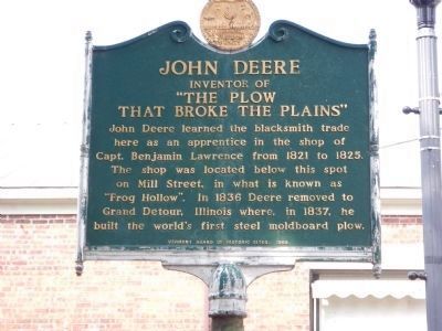
John Deere learned the blacksmith trade here as an apprentice in the shop of Capt. Benjamin Lawrence from 1821 to 1825. The shop was located below this spot on Mill Street, in what is known as "Frog Hollow". In 1836 Deere removed to Grand Detour, . . . — — Map (db m77845) HM
The Marble Works Memorial Bridge was constructed and generously donated by the Marble Works Partnership to the citizens of the town of Middlebury for their use and enjoyment.
The bridge is dedicated to the memory of the mechanics of Middlebury . . . — — Map (db m144478) HM
In 1792, the Vermont Legislature ensured Middlebury’s future prominence by choosing it as the site for Addison County courts. Three courthouses have been built in this area. The original clapboard courthouse shown on the right in the photograph, was . . . — — Map (db m136662) HM
Intersection of Rivers and Roads
Imagine traveling hundreds of miles in an ox-drawn wagon along muddy, rock-strewn, deeply rutted roads through the wilderness. In search of new homesteads, early settlers followed the same routes you took to . . . — — Map (db m89157) HM
Below the Otter Creek Falls was the site of Thomas Macdonough's shipyard, where the U.S.S. Saratoga was built in 40 days and other ships launched that defeated the British at the Battle of Plattsburgh, 1814. — — Map (db m75977) HM WM
Shaffe’s
c.1850/1963
Store throughout
its history. 1963 front retained
in restoration after
1992 fire.
State Register of Historic Places — — Map (db m141048) HM
Jonathon Fenton established a pottery and kiln near this site in 1801. He first made redware from clay found along the banks of the Mettowee River. He then became the first potter in Vermont to make salt-glazed stoneware. In 1810 he moved his . . . — — Map (db m78224) HM
Here, near Mt. Aeolus, Isaac Underhill opened the first marble quarry in 1785. Dorset quarries were most active in early 1800's when small slabs were used for hearths, doorsills and headstones. With better transportation and saws, larger blocks . . . — — Map (db m78226) HM
On the site at Hagar Brook stood the small clapboarded mint-house in which Reuben Harmon, Jr. coined copper for the Republic of Vermont, 1785-1788. When the Federal Government was instituted in 1789, Vermont abandoned minting. This rare currency of . . . — — Map (db m73639) HM
A Bridge From An Industrial Past to a Green Future
In New England, the industrial revolution was driven by water power.
With its many rivers, this made Bennington an early leader in manufacturing of many types. Many of these dams now lie . . . — — Map (db m193203) HM
A Brief History
The Village of North Bennington established McWaters Park in 2007. The Park is named in honor of Rob and Jean McWaters in recognition of local community involvement. Residents are
creating a perma forest consisting of berry . . . — — Map (db m193197) HM
Paper Mill History The former Vermont Tissue plant is located in Bennington in "Paper Mill Village” on the north side of the island on the Walloomsac River. The plant is a listed Brownfields site. The site is privately owned by AOE, Inc. who . . . — — Map (db m193206) HM
The Catamount Tavern, which was built in 1767, was originally named the Green Mountain Tavern. The Council of Safety and the “Green Mountain Boys” met here from 1767 to 1775. On May 9, 1775, Ethan Allen and 270 men, 40 whom were . . . — — Map (db m77053) HM
Named for the fine quality chisels and edge tools manufactured on site, the small village of Chiselville lies southwest of this 1870 Town lattice truss covered bridge. In 1853, a group of entrepreneurs led by Norman R. Douglass of Shaftsbury . . . — — Map (db m103815) HM
This water-powered mill on the Stevens River was built in 1872 by Alexander Jack. It originally housed a patented woolen print and dye works. In 1893, James Judkins retooled it as a wagon and woodworking shop. Judkins’ Shop was later run by sons . . . — — Map (db m136055) HM
Henry Stevens
Born in Barnet on December 13, 1791, and educated at Peacham Academy, Henry Stevens was at various times a farmer, innkeeper, mill owner, legislator, postmaster, temperance leader, stage line proprietor, and operator of the . . . — — Map (db m77691) HM
The Connecticut River, starting at the International Boundary, flows 380 miles to the Atlantic Ocean. In its course the river falls 1640 feet. In 1928, the New England Power Association started a two-year project to build one of the largest . . . — — Map (db m74467) HM
On this site, in 1849, Benjamin Greenbank converted an existing small mill into a 5-story woolen factory. As many as 45 people worked here to produce up to 700 yards of cloth a day. Greenbank's Hollow, as it became known, included a company store, . . . — — Map (db m61392) HM
This farm was established in 1883 by Elmer A. Darling (1848-1931), a native of East Burke who became part owner/manager of the world famous Fifth Avenue Hotel in New York City. After the hotel closed in 1908, Mr. Darling retired to the life of a . . . — — Map (db m75981) HM
Dedicated to the memory of Theodore Newton Vail (1848–1920), president of the American Telephone and Telegraph Company, a most generous benefactor of Lyndon Institute and Vail Agricultural School – one who had faith in the young people . . . — — Map (db m87926) HM
bought a farmhouse on this site in 1883. Continually enlarged by Vail, it became his permanent residence and office. Conferences held here culminated in the creation of the American Telephone and Telegraph Company with Vail its president, who . . . — — Map (db m75108) HM
On this site in 1852 the former Cottage Hotel opened for business owned by a Mr. Flint. Later, being part of the Calderwood Family holdings it was sold to Dominico and Maria Costa in 1920. —— By 1935 William T. Costa, Sr. and Joseph Caplan had . . . — — Map (db m180717) HM
After experimenting with new types of farm equipment, plows, and stoves, Thaddeus Fairbanks invented the platform scale here in 1830. With his brothers Erastus and Joseph, he founded the company which still bears their name. Many St. Johnsbury . . . — — Map (db m74468) HM
After experimenting with new types of farm equipment, plows and stoves, Thaddeus Fairbanks invented the platform scale here in 1830. With his brothers Erastus and Joseph, he founded the company which still bears their name. Many St. Johnsbury . . . — — Map (db m77603) HM
Had you stood at this location in the early 1800s, you would have had to lift your skirt off the dirt lane to step up onto the plank sidewalk or guard your hat from the danger of low wooden canopies. Pedestrians competed with horse and carriage on . . . — — Map (db m23579) HM
This impressive Italianate-style commercial building with a massive five-foot tall cast iron cornice was historically known as the Exchange Block. Designed by local builder William Townsend, the building was intended to stylistically complement the . . . — — Map (db m209095) HM
Original home of Ben & Jerry's Ice Cream Founded May 5, 1978 Placed in commemoration of their Tenth Anniversary Celebration June 4, 1988 — — Map (db m89108) HM
In 1962 architecture student Bill Truex experienced the transformation of Stroget, Copenhagen's main shopping area from traffic-snarled nightmare to successful pedestrian mall. Seven years later, while on the Burlington Planning Commission, Truex . . . — — Map (db m89110) HM
In 1962 architecture student Bill Truex experienced the transformation of Stroget, Copenhagen's main shopping area from traffic-snarled nightmare to successful pedestrian mall. Seven years later, while on the Burlington Planning Commission, Truex . . . — — Map (db m89112) HM
If you were standing here 200 years ago, you'd be all wet. The natural shoreline ends about 500 feet behind you. Burlington's first dock was built here in 1810. Before that the waterfront consisted of raft logs tied to the shore. Cargo delivery was . . . — — Map (db m183081) HM
Named for Thomas Chittenden, first governor of Vermont and great-great grandfather of Frank Howe. Frank and his father Lucian rebuilt this mill in 1885 changing from grinding with millstones to the new gradual reduction roller process. Grain was . . . — — Map (db m97753) HM
Huntington Gorge By 1802, John Preston had built a grist mill here at Richmond’s best water-power site. It was operated continuously for a century, last of all by the Robinson family. The Richmond Light and Power Co. converted the mill in 1903 . . . — — Map (db m86802) HM
The Apothecary Shop represents a late 19th-century druggist's shop. Prior to the Civil War, druggists gathered and dried herbs, grinding, distilling, and mixing them with a variety of substances to create medicinal remedies. By 1900, . . . — — Map (db m109129) HM
In the 18th and 19th centuries communities depended heavily on the village blacksmith as the primary source for tools, utensils, hardware, vehicle parts, and many other items. Many blacksmiths also served as farriers, . . . — — Map (db m109099) HM
Built in 1782 by Salmon Dutton, this house—the first dwelling brought to the Museum—was dismantled and moved from Cavendish, Vermont, in 1950. Dutton, who emigrated from Massachusetts, was a surveyor, town official, and toll road owner. . . . — — Map (db m109159) HM
For many years, this building served as the Shelburne village post office before it was moved to the Museum intact, on a specially designed railroad track running down Route 7. The ground floor re-creates a late 19th-century general store, post . . . — — Map (db m109124) HM
The earliest portion of this building was constructed by Captain Benjamin Harrington as a distillery, used to provide alcohol for the Captain's nearby inn. Constructed of hand-hewn timbers and rough planks, the building later served as Shelburne's . . . — — Map (db m109082) HM
The Museum's collection of 19th- and early 20th-century horse-drawn vehicles was initially displayed in Horseshoe Barn. With the addition of more than 150 wagons, sleighs, coaches, and fire equipment, the collection outgrew its original home. The . . . — — Map (db m109215) HM
The active slate-quarrying industry of Castleton, Vermont, provided ample raw materials for the construction of this holding structure, which houses two cells and a jailer's anteroom. A single barred window admits light into the building, which is . . . — — Map (db m109228) HM
The Rail Locomotive No. 220, built in 1915 by the American Locomotive [C]ompany of Schenectady, New York, was the last coal-burning, steam ten-wheeler used on the Central Vermont Railway. As a medium-sized 4-6-0 engine (4 leading wheels, 6 driving . . . — — Map (db m109153) HM
Constructed from historic timbers, the Print Shop exhibits a range of printing equipment that might have been found in an early 20th-century small-town print shop, from an 1820s handpress to a 1950 high-speed Heidelberg press. Late 19th-century . . . — — Map (db m109207) HM
Dr. William Seward Webb (1851-1926), president of the Rutland Railroad and the Wagner Palace Car Company, lived for part of the year in Shelburne, commuting to New York City in his own private car, the Ellesmere, which was similar to the . . . — — Map (db m109371) HM
Built in 1890 by Rutland Railroad President Dr. William Seward Webb (1851-1926), the Railroad Station was originally located near the center of Shelburne to serve passengers of the Central Vermont and Rutland Railroads. Designed by architect Robert . . . — — Map (db m109368) HM
The Sawmill building houses the Trescott-Shepard sawmill originally located in South Royalton, Vermont. The water-powered mill was built in the late 1700s on Mill Brook by Jeremiah Trescott and his partner, Captain Stevens. Trescott's descendants, . . . — — Map (db m109483) HM
The Settlers' House is constructed of hand-hewn beech and pine timbers. In the 18th and early 19th centuries, Vermont settlers, loggers, and trappers often built similar temporary log homes. Research suggests that this particular example was . . . — — Map (db m109479) HM
This building originally served a large Shaker community in Canterbury, New Hampshire, as a one-story horse and carriage stand. The simple, unadorned commercial structure was expanded in 1850 to provide storage space for brooms made and sold by . . . — — Map (db m109172) HM
Smokehouses are small, airtight stone structures where meat was preserved. Traditionally, butchered cuts were salted and then hung in a smokehouse above a smoldering fire of corn cobs and hickory wood. Meats remained in place for several days, or . . . — — Map (db m109223) HM
Hezekiah Barnes, a U.S. militia captain turned road surveyor, strategically located his inn and trading post in Charlotte on opposite sides of the main stage route from Montreal. Built in the Georgian style, the exterior of the inn features . . . — — Map (db m109219) HM
Stone Cottage is constructed of limestone laid in straight courses rather than in the more common scatterstone technique. It was originally built as a farmhand's house; the first tenants were a family of five, including husband and wife, two . . . — — Map (db m109083) HM
The Rail Car Grand Isle (1899) was one of the last private cars built by the Wagner Palace Car Co. before Pullman took control of the company at the end of 1899. The car was used by Dr. William Seward Webb and the Rutland Railroad until 1914, when . . . — — Map (db m109379) HM
Built adjacent to the Variety Unit to reflect the "continuous architecture" building style common throughout New England, the Toy Shop displays an array of children's playthings: transportation toys, mechanical banks, an operating model train, . . . — — Map (db m109085) HM
Constructed using historic building materials, the Weaving Shop exhibits a variety of hand-spinning and weaving equipment and interprets American textile traditions practiced in a 19th-century weaving shop.
On view are processing . . . — — Map (db m109174) HM
The town of Brighton, VT., dedicates this plaque to the memory of one of its prominent public officials, Charles F. Maw, who was born in Nettleham, Lincolnshire, England in 1883.
With only an 8th grade education, Charles F. Maw emigrated to . . . — — Map (db m221718) HM
The production of pre-packed pharmaceutical products, known as patent or proprietary medicines, flourished in the late 19th century. Dr. Burney James Kendall (1845-1922) opened a drug store in 1870 and soon sold his own remedies. Here in 1880, the . . . — — Map (db m177611) HM
When the Champlain Canal was
completed in 1823 and shipping to
the south opened up a huge market
to the West, St. Albans merchants
benefited from the boom. Canal
boats sailed south up the Lake to
Whitehall, and once the sails . . . — — Map (db m140057) HM
From here, "The Chazy Landing Ferry," completed the major automobile route across northern Lake Champlain from Isle La Motte, VT, to Chazy Landing, NY, before the Rouses Point-Alburgh bridge was built. In 1905 Will Sweet designed, built, owned, and . . . — — Map (db m74718) HM
Here Ethan Allen's cousin, Ebenezer, made the first settlement on South Hero. From his tavern, Ethan, one of the "heroes" for whom the islands were named, started homeward across the ice to Burlington, Feb. 11, 1789. Stricken en route, the Green . . . — — Map (db m86595) HM
James Wilson, a Bradford farmer and self-taught engraver, in early 1800’s made and sold the first geographical globes in the U.S. Adm. Chas. Clark, born here in 1843, was Captain of the “Oregon”, which sailed around the Cape Horn to . . . — — Map (db m65832) HM
Located 100 yards beyond this marker is the site where James Wilson had his home and workshop. Between 1808 and 1810 Wilson made and sold the first terrestrial and celestial globes in North America. Born in Londonderry, N.H., in 1763, Wilson was a . . . — — Map (db m87995) HM
Samuel Morey, resident of Orford and later Fairlee, successfully operated a steamboat on the Conn. River in 1793. Making over 4000 experiments, this early scientist patented an internal combustion engine in 1826 to anticipate the age of the motor . . . — — Map (db m32118) HM
In the 1790s a body of ore was discovered here, leading to the production of copperas from 1809 - 1880s and the intermittent production of copper from 1832 - 1958. The mine site covered 850 acres, and over three million tons of ore were extracted . . . — — Map (db m64920) HM
Strafford was granted its charter on August 12, 1761. Land near here was chosen for the town's first settlement by its earliest pioneers, Ezekiel Parish and Frederick Smith. Both men with their families established homesteads in this vicinity by . . . — — Map (db m107647) HM
In this area, what may have been the first use of hot blast to smelt copper adjacent to a mine in the United States took place. During the winter of 1833-1834, Isaac Tyson, Jr., invented a hot-blast system for smelting copper. Assisted by smelting . . . — — Map (db m94486) HM
Thomas Davenport was born on the West Hill in 1802 and worked in a blacksmith shop by the village stream. Later, in Brandon, invented the first commutator, and, in 1837, patented the first electric motor. — — Map (db m86037) HM
Born on the West Hill July 9, 1802. Died at the age of 49, July 6 1851, in Salisbury, VT. Buried in Brandon. Near this tablet stood the blacksmith shop where he learned his trade. He invented and made the first ELECTRIC MOTOR in Brandon, Vermont . . . — — Map (db m86038) HM
Born in Barton on February 16, 1843 to a hard working farm family, Henry Leland carried into his life the strength and quality of his family’s work ethic adding to it his gift and love for precision. By 1890, Leland was in Detroit where he had . . . — — Map (db m75107) HM
Newport had reached its pinnacle of success at the dawn of the 20th century, when three of Newport's most impressive civic buildings were constructed[;] the Goodrich Memorial Library, the Orleans County Courthouse and the Federal Building. These . . . — — Map (db m122745) HM
When Calvin Arnold of Randolph, Vermont, arrived in the Vermont-Quebec border region in about 1800, it was a vast land of big forests, big lakes, and free running streams. Native Americans, many of them Abenaki, called it their home. They hunted, . . . — — Map (db m198876) HM
The grand Memphremagog House, c. 1838-1907, the core of which was one of the original buildings constructed on Main Street, dominated the hotel business in Newport, though a few other smaller hotels were also built downtown, near the railroad . . . — — Map (db m122666) HM
The City of Newport's development was dramatically altered by the arrival of the railroad in the mid-nineteenth century. From the south, in 1863, the Connecticut and Passumpsic Railroad arrived in Newport. In 1873, a second line, the Missisquoi . . . — — Map (db m122671) HM
For both the original Native Americans and the earliest settlers, Lake Memphremagog was important for transportation and portage, but it also would develop an illustrious history as a tourist destination. Once fronted by the grand Memphremagog . . . — — Map (db m122683) HM
Mechanicsville was a village center in the Town of Mount Holly, which was chartered in 1792. The village prospered with the growth of water-powered manufacturing, that included sawmills, gristmills, wheelwrights, furniture shops, and the A.P. Chase . . . — — Map (db m78153) HM
Ironworking began at Forest Dale in 1810 using local ore. By 1823 a blast furnace was producing pig iron and a variety of ornamental iron. The Green Mountain Iron Company acquired the facility in 1854 to produce parlor stoves. The furnace was . . . — — Map (db m78178) HM
The ‘little giant’ of national politics, born in Brandon in 1813, later moved to Middlebury to learn cabinet making. Returning to Brandon, he attended the Academy. Moving to Illinois in 1833, his career merged with the stream of American politics, . . . — — Map (db m76006) HM
Drilling the first modern oil well in the United States on August 27, 1859 at Titusville, Penna., Drake struck oil at 69 feet and launched one of the world’s great industries. On a farm on Drake Road, near this spot, he lived as a boy and attended . . . — — Map (db m78199) HM
In 1843, John Cain erected a slate pencil mill along Sucker Brook. Benjamin and James Adams bought the mill in 1853, and began mass-producing slate pencils as the Adams Manufacturing Co. Soon, after acquiring more land and business partners, the . . . — — Map (db m97291) HM
James Mead, Rutland's first settler, arrived at these falls on the Otter Creek in 1769. The next year he and his family were given shelter by members of the Caughnawaga tribe while they finished their log cabin. Mead built saw and grist mills on the . . . — — Map (db m77440) HM
The last of a dozen mills that dotted Mill River during the 18th & 19th century. Kingsley Grist Mill stands just upstream of the 1870 Town lattice truss covered bridge.
Kingsley's Mill, the only mill ever designed and built by nationally known . . . — — Map (db m74431) HM
(side 1)
John Porter Bowman and Laurel Hall
John Bowman was born in 1816 in his grandparents’ tavern at Pierce’s Corner, VT. At 15 he began working in tanneries in Rutland and New York. In the 1840s he opened Tannery Crossing in . . . — — Map (db m199457) HM
This area of Vermont is known for its high quality slate; the first quarry was opened on Scotch Hill in 1839 by Alonson Allen & Caleb Ranney. Allen began the first manufacture of roofing slate in Vermont in 1848. By 1869 there were seventeen . . . — — Map (db m78200) HM
Matthew Lyon, Irish-born leading grantee, built grist, saw and paper mills here, 1783, and a forge above. He ran first store, inn, and newspaper. As Congressman from Vermont he was jailed under the Sedition Law and later elected from Kentucky and . . . — — Map (db m78211) HM
Born in Rutland, Ripley enlisted in the 9th Vermont in 1862 and fought at Harper’s Ferry, Chaffin’s Farm and Second Fair Oaks. As brigade commander of the Army of the James, the general led the first Union troops into the Confederate capitol of . . . — — Map (db m103338) HM
Near this site Albert W. Gray manufactured his horse power treadmills, which he invented and patented in 1844 and 1856. He also invented a corn sheller, patented in 1836, and a machine for making wrought iron nails.
For over 50 years the shop, . . . — — Map (db m60664) HM
A sawmill was built in 1798 by Pittsford's Woodruff family about 275 feet to the north on Sugar Hollow Brook, a Furnace Brook tributary. The mill was replaced and a dam built c.1870 by the Norse family. An ice house was added, with ice cut from the . . . — — Map (db m97284) HM
Side 1 In 1791, Israel Keith built an iron blast furnace two miles east of here, adjacent to what is now Furnace Brook. Materials for the smelting process included iron ore, manganese, and charcoal from Chittenden, with limestone flux from . . . — — Map (db m103340) HM
Slate was first discovered in 1839 and later worked by Col. Alonson Allen at the Scotch Hill Quarry near Fair Haven in 1848. The Hooker brothers opened the Poultney Eureka Quarry in 1851. At the peak in the 1890's there were more than 80 quarries . . . — — Map (db m229714) HM
The earliest marble was quarried by the Humphrey brothers in 1836. They were followed by successive marble companies. In 1870 Redfield Proctor took over in receivership and brought the Vermont Marble Company to world prominence. Building contracts . . . — — Map (db m77969) HM
John Deere was born February, 7th, 1804 the third son of William Rinold Deere and Sarah Yates Deere. It is presumed that Sarah gave birth to John at home; over William Deere’s Rutland tailor shop located on the east side of Main St. across from the . . . — — Map (db m77993) HM
Thousands of immigrants from Ireland, Italy and across Europe helped make this region an epicenter of the marble Industry. Quarries drew workers and artists to Rutland County starting in the late 1700s. By the late 1800s, Vermont Marble Company . . . — — Map (db m229878) HM
For many years after 1808, farm implements were manufactured here. Lyman Batcheller & his sons bought the forge in 1835, and their forks became famous throughout the U.S. and Europe. In 1902 they merged with the firm making True Temper products, . . . — — Map (db m95453) HM
West Pawlett was originally known as “Mark's Corners.“ Possibly named after Ira Marks ran a starch factory on Indian River in 1843. This intersection was the center of activity in the town of Pawlet during the second half of the 19th . . . — — Map (db m160046) HM
Clarence W. Fitch, born in 1885 in East Montpelier, was a leader of the cooperative movement of the mid-20th century, when rural families banded together to create social and cultural organizations for the benefit of their communities. He founded . . . — — Map (db m135340) HM
When Barre was first established the primary settlement and town center was located in South Barre, at that time called the Upper Village, where the town's two primary roads intersected. Eventually, as water power sites were discovered and . . . — — Map (db m156424) HM
This small community – once called Rich's Hollow – was settled in the late 1700s and during the 19th century was an important cultural and industrial center area. Samuel Rich created North Montpelier Pond by damming the Kingsbury Branch . . . — — Map (db m87997) HM
In the late 1950’s Rock of Ages experimented with making lanes out of granite for use in commercial bowling alleys. Although a few such alleys were created, the concept never caught on. This prototype was used for many years by employees and . . . — — Map (db m81271) HM
The Winooski River and other waterways were paths through the wilderness for Native Americans and early explorers. The banks along these waterways became natural settlement sites, and the falls provided water power for early industry. In 1805, . . . — — Map (db m222223) HM
This railroad turntable, constructed in 1907, is a physical reminder of the once thriving granite industry and supportive railroad infrastructure along the Montpelier Riverfront. Also known as a “gallows turntable” due to its shape, this turntable . . . — — Map (db m188108) HM
This panorama of the Montpelier riverfront portrays the Winooski River at its zenith of industrial and railroad activity. The river is high, which suggests that Main Street dam was providing power to nearby mills and factories. Ample trackage . . . — — Map (db m222104) HM
The Village of Bellows Falls, within the Town of Rockingham, has served as a river and overland crossroad for commerce and travel by foot, stagecoach, riverboat, train, truck and automobile.
With wood, brick, iron, steel, and stone, . . . — — Map (db m65789) HM
The Bellows Falls Waypoint Center stands in an old railyard which once served the Boston and Maine Railroad. Once the railroads came through, in 1849, the area was built up with many storage buildings used by local businesses for receiving . . . — — Map (db m65787) HM
121 entries matched your criteria. The first 100 are listed above. The final 21 ⊳