On Chesterfield Avenue (Virginia Route 36), on the right when traveling west.
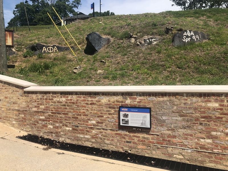
"The Rocks" became a popular place for students to meet down on the Appomattox River. The group seen here is from the "Normal Class" of 1913. The term "normal" referred to teacher training programs. The "collegiate institute" included training in . . . — — Map (db m149617) HM
On Fleet Street (State Highway 36) at Chesterfield Avenue (State Highway 36), on the right when traveling north on Fleet Street.
The site of an Appomattox Indian village burned in 1676 in Bacon's Rebellion, the present town of Ettrick stands on land that belonged to "Ettrick Banks" and "Matoax," the boyhood plantation of John Randolph of Roanoke. In 1810 Campbell's Bridge . . . — — Map (db m14622) HM
On Chesterfield Avenue (Virginia Route 36) south of Randolph Street, on the right when traveling south.
In honor of those of Ettrick
who served in the Armed Forces
and
in memory of these who made
the Supreme Sacrifice in World War II
C. Leslie Clarke • William E. Laffoon • Robert E. Marable • Charlie L. Nichols • Charles C. . . . — — Map (db m149623) WM
On Chesterfield Avenue (Virginia Route 36), on the right when traveling west.
A small village was established by the early 1800's along the Appomattox River with 200 workers who operated the cotton mill. Millworkers' housing from the mid- 19th century onward is one of the outstanding features of the Ettrick Historic District. . . . — — Map (db m149616) HM
On Chesterfield Avenue (Virginia Route 36), on the right when traveling west.
Frederick Francoz Simms was born to Frederick H. and America T. Ayer Simms on May 8, 1884 in New Orleans Parish. A graduate of Southern University and Agricultural and Mechanical College, commonly known today as Southern University in Baton . . . — — Map (db m149605) HM
On Chesterfield Avenue (Virginia Route 36), on the right when traveling west.
The Southside Railroad, completed in 1854, was one of the most important supply routes in southern Virginia during the American Civil War (1861-1865). With tracks laid east to west across the state, the railroad began began at City Point in . . . — — Map (db m149611) HM
On College Avenue, 0.1 miles south of Hayden Street, on the right when traveling south.
Project Overview: In 1907, the trustees of what is now Virginia State University voted to build a new President's residence at a cost of $3,300. Named for the school's first principal, James Storum, Storum Hall is the University's oldest . . . — — Map (db m149622) HM
On College Avenue at Hayden Street, on the right when traveling south on College Avenue.
Project Overview: Vawter Hall was named for Captain Charles E. Vawter, a life-long educator and Chairman of the board of the Virginia Normal and Industrial Institute Board of Trustees from 1902 until his death in 1905. Constructed in 1908, it . . . — — Map (db m149619) HM
On Chesterfield Avenue (Virginia Route 36), on the right when traveling west.
Directly across the river, Petersburg began to develop into a major industrial and commercial center. The town sprang up at the Appomattox River's fall line, where rocks and shallows prevented cargo boats from sailing upstream. Planters from the . . . — — Map (db m149613) HM
On Chesterfield Avenue (Virginia Route 36), on the right when traveling west.
The Virginia State Normal School, now Virginia State University, purchased a two-acre tract with a mill building from John Stearns for the sum of $35,000 in 1922. The mill was used for silk dying and weaving and was one of many water powered mills . . . — — Map (db m149612) HM
On Chesterfield Avenue (Virginia Route 36), on the right when traveling west.
Simms Hall was used to educate tradesmen. This is the only remaining structure from the building. It is believed to be a demonstration of the art of masonry. — — Map (db m149610) HM
On Chesterfield Avenue (Virginia Route 36), on the right when traveling west.
Virginia State University was founded on March 6, 1882, when the legislature passed a bill to charter the Virginia Normal and Collegiate Institute. The bill was sponsored by Delegate Alfred W. Harris, a Black attorney whose offices were in . . . — — Map (db m149618) HM
On Matthews Jefferson Drive at East River Road, on the right when traveling east on Matthews Jefferson Drive.
Virginia State University was chartered by the Virginia legislature in 1882 as the Virginia Normal and Collegiate Institute. Delegate Alfred W. Harris, an African American attorney in Petersburg, championed the charter and supported it . . . — — Map (db m180147) HM
On Pickett Avenue (Virginia Route 600) at Ferndale Avenue, on the right when traveling south on Pickett Avenue.
Originally named the Providence Manufacturing Company, Matoaca Manufacturing (Mill) had its beginning here late in the 1700s on land then known as Olive Hill Plantation. Initially operated as a grist mill, by 1838 it was producing cotton cloth and . . . — — Map (db m48473) HM
On River Road (Virginia Route 36) at Winfred Avenue, on the right when traveling east on River Road.
On 26 Feb. 1921, Delta Omega became the first graduate chapter of Alpha Kappa Alpha Sorority Inc. chartered on the East Coast, the fourth graduate chapter in the U.S., and the first Greek-letter organization at Virginia Normal and Industrial . . . — — Map (db m224396) HM
On River Road (Virginia Route 36) west of Winfree Avenue, on the left when traveling west.
Mattoax was located to the south on the Appomattox River. John Randolph, Sr., built a house there in the 1770s that burned after 1810; it was the boyhood home of his son, John Randolph of Roanoke. Mattoax also was the residence of St. George Tucker, . . . — — Map (db m19637) HM
Near Duncan Road (Virginia Route 670), on the left when traveling south.
As the Vermonters pushed closer to the Confederate fortifications, they encountered the multiple rows of obstructions specifically designed to pin down an attacking force. Here, the Confederates extracted a terrible toll on the desperate Federals, . . . — — Map (db m15324) HM
Near Duncan Road (Virginia Route 670), on the left when traveling south.
The Union high command began making preparations to attack the Confederate lines on the Boisseau Plantation shortly after the capture of the Rebels’ picket line on March 25. Final orders arrived on the afternoon of April 1 for a dawn assault the . . . — — Map (db m181490) HM
Near Duncan Road (Virginia Route 670), on the left when traveling south.
The Confederate troops who defended this portion of the works belonged to Brigadier General James H. Lane’s North Carolina Brigade. These Tarheels assumed responsibility here on March 30 after McGowan’s Brigade moved several miles west to plug a gap . . . — — Map (db m15375) HM
Near Duncan Road (Virginia Route 670) 1 mile east of Boydton Plank Road (U.S. 1), on the left when traveling south.
At various intervals along their lines, Confederate defenders constructed gun emplacements, called redans, such as the one in front of you. Each redan would hold as few as one or as many as six cannons. Virtually every square inch of ground in front . . . — — Map (db m192468) HM
Near Duncan Road (Virginia Route 670), on the left when traveling south.
The main line of entrenchments behind you was only one part of the entire defensive network established here by the Confederates. Southern soldiers removed all the trees in front of their works to create a clear field of fire. They used the wood to . . . — — Map (db m175181) HM
Near Duncan Road (Virginia Route 670), on the left when traveling south.
The passage of the picket posts and abatis shattered regimental formations in the Vermont Brigade. The attack degenerated into a rush of disorganized men rather than an example of textbook tactics. Orderly Sergeant Thomas H. McCauley of the . . . — — Map (db m154894) HM
Near Duncan Road (Virginia Route 670), on the left when traveling south.
1st Lieutenant Evander McNair Robeson Company K, 18th North Carolina Infantry, Lane’s Brigade, Wilcox’s Division, Third Corps Resident: Bladen County, North Carolina Enlisted: April 1861 A comrade of Robeson’s wrote about the battle on April 2, . . . — — Map (db m15325) HM
Near Duncan Road (Virginia Route 670), on the left when traveling south.
1st Lieutenant Octavius Augustus Wiggins Company E, 37th North Carolina Infantry, Lane’s Brigade, Wilcox’s Division, Third Corps Resident: Halifax County, North Carolina Enlisted: June 1862 Wiggins was wounded near here during the Breakthrough . . . — — Map (db m15326) HM
Near Duncan Road (Virginia Route 670), on the left when traveling south.
The shallow depression in front of you marks the location of what was once a substantial dwelling. Archaeologists excavated this site in 1997 and discovered a well-preserved brick foundation and flooring. The artifacts recovered from the site . . . — — Map (db m15407) HM
On Boydton Plank Road (U.S. 1) at Duncan Road (County Route 670), on the left when traveling west on Boydton Plank Road.
To the memory of A.P. Hill, Lt - Gen CSA
He was killed about 600 yards northwardly from this marker, being shot by a small band of stragglers from the Federal lines on the morning of April 2nd, 1865.
Erected by A.P. Hill Camp Sons of Confederate . . . — — Map (db m3595) HM
Near Hofheimer Way, on the left when traveling south.
Following their breakthrough near the Boisseau and Hart Farms, Federal soldiers of Major General Horatio G. Wright’s Sixth Corps poured over the earthworks southwest of Petersburg and into the Confederate rear. Some Federals penetrated as far as a . . . — — Map (db m15428) HM
Near Duncan Road (Virginia Route 670), on the left when traveling south.
This bridge spans a small branch of Arthur’s Swamp. The ravine created by this streamlet had important consequences for both the defending Confederates and the attacking Union troops. The earthen mounds immediately in front of you are the remains . . . — — Map (db m15418) HM
Near Duncan Road (Virginia Route 670), on the left when traveling south.
Near here, the 6th Maryland Infantry (Union) made their penetration of the Confederate fortifications. Major Clifton K. Prentiss, a 29-year-old from Baltimore, helped lead his unit in the Breakthrough only to fall wounded with a rifle ball in his . . . — — Map (db m15332) HM
On Boydton Plank Road (U.S. 1) 0.3 miles north of White Oak Road, on the right when traveling north.
An old mill stood here, with earthworks. On October 27, 1864, General Hancock, coming from the south, attempted to cross the run here and reach the Southside Railroad. He was supported on the east by Warren's (Fifth) Corps. The Confederates, . . . — — Map (db m180608) HM
On Boydton Plank Road (U.S. 1) at White Oak Road, on the right when traveling north on Boydton Plank Road.
Leaving from a point along the Confederate right flank on Boydon Plank Road on 14 Sept. 1864, Maj. Gen. Wade Hampton took about 3,000 Confederate cavalrymen and rode more than 100 miles around the rear of the Union army. Reaching Coggins’ Point on . . . — — Map (db m14775) HM
On West Washington Street (U.S. 1) at 7th Avenue, on the right when traveling east on West Washington Street. Reported permanently removed.
Established in 1869 in temporary quarters at Howard's Grove near Richmond. In 1870 it came under control of the State. In 1885 it was moved to the present location, the site of "Mayfield Plantation", which was purchased and donated to the State by . . . — — Map (db m19000) HM
On West Washington Street (U.S. 1) at 7th Avenue, on the left when traveling west on West Washington Street.
Central State Hospital traces its origins to a mental health hospital for African Americans established ca. 1866 by the Freedmen's Bureau at Howard's Grove, near Richmond. The Commonwealth of Virginia assumed control of the facility in 1870. In 1882 . . . — — Map (db m180087) HM
On 7th Avenue, 0.1 miles south of Accomac Street, on the right when traveling south.
This cemetery is the final resting place for thousands of patients treated at the nation's first stand-alone psychiatric hospital for African Americans, originally known as the Central Lunatic Asylum and later renamed Central State Hospital. The . . . — — Map (db m180083) HM
On Boydton Plank Road (U.S. 1) at Albemarle Street, on the right when traveling north on Boydton Plank Road.
Named for the Whitworth family of Mayfield, the farm on which it was built, this outpost (a quarter-mile east) and Fort Gregg, 400 yards to the south, were constructed to protect the western approaches to Petersburg during the 1864-1865 siege. On 2 . . . — — Map (db m180775) HM
Near Duncan Road (Virginia Route 670), on the left when traveling south.
The two mounds on the lawn in front of you mark the locations of winter huts built by soldiers of Brigadier General Samuel McGowan’s South Carolina brigade during the winter of 1864-65. McGowan’s troops established several camps in this area . . . — — Map (db m15410) HM
Near Duncan Road (Virginia Route 670), on the left when traveling south.
Brigadier General Samuel McGowan’s South Carolina Brigade spent the winter of 1864-1865 very close to the fortifications they defended. A temporary scarcity of building materials in the early winter compelled many of McGowan’s men to rely on their . . . — — Map (db m15424) HM
On West Washington Street (U.S. 1) at Boydton Plank Road (Business U.S. 460), on the right when traveling west on West Washington Street.
To the north stood William Turnbull's house, Edge Hill, headquarters of Gen. Robert E. Lee from 23 Nov. 1864 to 2 Apr. 1865 during the siege of Petersburg. Here, after dawn on 2 Apr., Lee learned of the Union attack that soon shattered his lines and . . . — — Map (db m17547) HM
Near Duncan Road (Virginia Route 670), on the left when traveling south.
Pamplin Historical Park has created these replica earthworks to suggest how this area might have looked during the winter of 1864-65. Both armies at Petersburg constructed long lines of field fortifications. Engineer officers used standard manuals . . . — — Map (db m15427) HM
Near Duncan Road (Virginia Route 670), on the left when traveling south.
In the hours, days, and years after the Breakthrough, many Union soldiers boasted that they or their regiment were the first troops to capture the Confederate works on the morning of April 2. Darkness, the chaos of the attack, and the wide Federal . . . — — Map (db m15311) HM
“This fort has cost more labour than any other, has afforded an admirable lesson in engineering, and is one of the sights to show to strangers. Further than this I doubt the value of its elaborateness.” - Col. Charles . . . — — Map (db m7861) HM
On Boydton Plank Road (U.S. 1) 0.3 miles north of White Oak Road, on the right when traveling north.
Lee's right wing was defended by earthworks on this stream, here and to the east. These works were unsuccessfully attacked by Union forces, February 5-7, 1865. On the morning of April 2, 1865, they were stormed by Union troops. — — Map (db m180609) HM
On Duncan Road (Virginia Route 670) 0.6 miles south of Wheaton Road (Virginia Route 674), on the right when traveling south.
"Time is passing and Richmond is still not ours. I think it cannot be long now before the tug will come which, if it does not secure the prize, will put us where the end will be in sight."
—Gen. Ulysses S. Grant, USA
"The only . . . — — Map (db m184324) HM
Near Duncan Road (Virginia Route 670) 0.6 miles south of Wheaton Road (Virginia Route 674), on the right when traveling south.
"Every point of the enemy's [line] was carefully felt and examined for a weak point; none such, however, was found."
—Gen. John F. Hartranft, USA
"Our boys went into line with their accustomed cheer, and the yankees seeing our . . . — — Map (db m184682) HM
Near Duncan Road (Virginia Route 670) 0.6 miles south of Wheaton Road (Virginia Route 674), on the right when traveling south.
"We expected to 'rush' the rebels, but on reaching the creek we found it too deep for fording, and the enemy in good rifle-pits on the other bank, about 25 yards away."
—Pvt. Richard McBride, 190th Pennsylvania Infantry, USA
"The . . . — — Map (db m184870) HM
Near Duncan Road (Virginia Route 670) 0.6 miles south of Wheaton Road (Virginia Route 674), on the right when traveling south.
"Newspapers try to make the best of our [failed] 'reconnaissance.' This affords a vast deal of amusement, considering there were greater exertions and preparations made for this expedition than any previous one."
—Col. Charles S. . . . — — Map (db m184895) HM
Near Hofheimer Way, on the left when traveling south.
This upper middle-class dwelling is one of the earliest surviving structures in Dinwiddie County. Unfortunately, the name of original builder has been lost to time. The architectural evidence suggests that the house evolved in four phases between . . . — — Map (db m11974) HM
Near Duncan Road (Virginia Route 670), on the left when traveling south.
The design of this building is typical of slave quarters built on Virginia plantations during the 1840s and 1850s. Each side provided space for one slave family, with a room downstairs for living and working and a loft for sleeping. The right side . . . — — Map (db m15444) HM
Near Duncan Road (Virginia Route 670), on the left when traveling south.
A nineteenth-century kitchen garden of one acre, about the size of a football field, could be maintained by one person and provide produce for 10-15 people. The management of the kitchen garden generally fell to the women of the household. The . . . — — Map (db m15451) HM
Near Duncan Road (Virginia Route 670) 0.5 miles south of Boydton Plank Road (U.S. 1), on the left when traveling south.
This monument honors the soldiers of
Lane's North Carolina Brigade, who defended this
portion of the Confederate works on April 2, 1865.
The Union assault struck first near this spot, triggering
hand-to-hand fighting that claimed more than . . . — — Map (db m184673) HM WM
Near Duncan Road (Virginia Route 670), on the left when traveling south.
Lieutenant Colonel Ronald A. Kennedy 5th Vermont Infantry, 2nd Brigade, 2nd Division (Getty), Sixth Corps Resident: Concord, Vermont Enlisted: June 18, 1861 Kennedy and his men passed this very spot during their attack on April 2, 1865. He . . . — — Map (db m15329) HM
Near Duncan Road (Virginia Route 670), on the left when traveling south.
Brigadier General Samuel McGowan, a 43-year-old lawyer and politician from Abbeville, South Carolina, commanded the troops responsible for maintaining these fortifications from October 1864 through March 1865. McGowan’s Brigade consisted of five . . . — — Map (db m15413) HM
Near Boydton Plank Road (U.S. 1) 0.2 miles south of Duncan Road (Virginia Route 670), on the left when traveling south.
Obstructions, like the reproductions displayed here, played an important role in Civil War field fortifications. These obstacles broke the forward momentum of assaulting troops and maximized and attacker’s exposure to the defenders’ fire. . . . — — Map (db m69935) HM
Pamplin Historical Park
&
The National Museum
Of the Civil War Soldier
Base of Sculpture:
My Thoughts And Heart Are With You At Home,
But My Duty Lies Here With Cause And Comrades
Back of . . . — — Map (db m86077) WM
On Boydon Plank Road (U.S. 1) at Duncan Road (Virginia Route 670), on the left on Boydon Plank Road.
Here, the Union’s Sixth Army Corps broke through the Confederate line defending Petersburg, causing a series of actions which eventually led to the evacuation of the city by Lee’s army that evening. Nearby, Confederate General A.P. Hill was killed . . . — — Map (db m6080) HM
Near Church Road (Virginia Route 672) at Flank Road, on the left when traveling north.
"When a man is on picket at night he is monarch of all he surveys. No one living has more absolute power than he. His word is law."—Corp. Lewis Bissell, 2nd Connecticut Heavy Artillery, USA
"I have seen veterans of three full . . . — — Map (db m85913) HM
Near Church Road (Virginia Route 627) at Flank Road, on the left when traveling north.
From here at Fort Welch, you can see the ground over which soldiers struggled during three distinct battles. On October 2, 1864, Federals advanced across the ground to your left in an attempt to capture the key Confederate intermediate supply route, . . . — — Map (db m85935) HM
Near Church Road (Virginia Route 672) at Flank Road, on the left when traveling north.
"We have set what we call Johnny catchers ... long poles set into the ground with the upper end about as high as a man's head and they are so thick that a rabbit could not crawl through."—Corp. Andrew W. Burwell, 5th Wisconsin . . . — — Map (db m155596) HM
Near Church Road (Virginia Route 672) at Flank Road, on the right when traveling south.
“The charge of Major-Gen. Wright’s veterans under cover of the darkness and mist … will forever live in history as one of the grandest and most sublime actions of the war.”—Sgt. Newton J. Terrill, 14th New Jersey Infantry, USA . . . — — Map (db m184488) HM
Near Church Road (Virginia Route 672) at Flank Road, on the right when traveling south.
“The charge of Major-Gen. Wright’s veterans under cover of the darkness and mist … will forever live in history as one of the grandest and most sublime actions of the war.”—Sgt. Newton J. Terrill, 14th New Jersey Infantry, USA
“The . . . — — Map (db m184489) HM
Near Church Road (Virginia Route 672) at Flank Road, on the right when traveling south.
"There is every indication that a heavy force is being massed in our front, and if a charge is made, this line cannot possibly be held by these few men."
—Unidentified North Carolina picket, CSA
"Nothing could be seen, nothing . . . — — Map (db m184517) HM
Near Church Road (Virginia Route 672) at Flank Road, on the right when traveling south.
As the enemy must have massed on the right of our line, they must have left their own line weak. How would it do for us to attack along the whole length of our line?"
—Gen. Horatio G. Wright, USA
"The enemy swarmed up to the . . . — — Map (db m184530) HM
Near Church Road (Virginia Route 672) at Flank Road, on the right when traveling south.
"Gentlemen we are going to have a h—l of a fight at early daylight ... if any of you have anything to say to your folks, wives, or sweethearts make your story short and get what sleep you can."—Col. James Hubbard, 2nd Connecticut Heavy . . . — — Map (db m184633) HM
Near Church Road (Virginia Route 672) at Flank Road, on the right when traveling south.
"No doubt a few more days will settle the fate of Petersburg. I shall be glad to welcome the dawn of peace, for I am tired of bloodshed."
—Col. Elisha Hunt Rhodes, 2nd Rhode Island Infantry, USA
"A very small effort on the part . . . — — Map (db m184650) HM
On Duncan Road (Virginia Route 670), on the left when traveling south.
Has been designated a National Historic Landmark This site possesses national significance in commemorating the history of the United States of America. In the predawn darkness of April 2, 1865, the Union Sixth Corps successfully breached the . . . — — Map (db m6253) HM
Near 7th Avenue, 0.5 miles north of Albermarle Street. Reported permanently removed.
In 1938 the Virginia Assembly chartered a residential care facility for mentally retarded African-American males between 8 and 21 years of age. The Petersburg State Colony for the Negro Insane, as it was named, was located on the present site . . . — — Map (db m23455) HM
Near Duncan Road (Route 670), on the left when traveling south.
Sergeant John E. Buffington 6th Maryland Infantry, 2nd Brigade, 3rd Division (Seymour), Sixth Corps Resident: Carroll County, Maryland Enlisted: August 1862 Sergeant John Ezra Buffington, with five other men of his regiment, stormed the . . . — — Map (db m15379) HM
On 7th Avenue, 0.1 miles north of Simpson Road (Virginia Route 142), on the right when traveling north.
With the Confederate defeat at Five Forks on April 1, 1865, Confederate general Robert E. Lee's defense of Petersburg and Richmond had been lost. On April 2, Union General Ulysses S. Grant ordered a general assault against the Petersburg lines and . . . — — Map (db m78094) HM
On Flank Road at Church Road (Virginia Route 672), on the right when traveling west on Flank Road.
Throughout the summer of 1864 Union General Ulysses S. Grant made several unsuccessful assaults against the Confederate defenses around Richmond and Petersburg. Then, in the fall of 1864, the Union won decisive victories on other fronts of the war. . . . — — Map (db m78095) HM
Near Duncan Road (Virginia Route 670) 0.7 miles east of Boydton Plank Road (U.S. 1).
The Sixth Maryland Infantry attacked over this ground in the pre-dawn hours of April 2, 1865. A portion of the regiment, led by Major Clifton K. Prentiss, poured over the Confederate works here, suffering numerous casualties in the process, . . . — — Map (db m180610) HM
On Bedford Street, 0.2 miles north of 7th Avenue, on the right when traveling north.
In 1938 the Virginia General assembly chartered a residential care facility of African American males aged 8-21, with mental disabilities. The Petersburg State Colony for the Negro Insane, as it was named was located on the present site of . . . — — Map (db m180086) HM
Near Duncan Road (Virginia Route 670), on the left when traveling south.
Major General Horatio G. Wright deployed the 14,000 attackers of his Sixth Corps in a wedge-shaped formation. Although the entire battle front extended for nearly a mile, the point of the wedge was here, manned by the Vermont Brigade commanded by . . . — — Map (db m15307) HM
On Hofheimer Way, on the left when traveling south.
Welcome to the Banks House. This 18th-century home was typical of other upper-middle class farms in Dinwiddie County, except for 24 hours on April 2-3, 1865 when it became military headquarters for Lieutenant General Ulysses S. Grant. From here, . . . — — Map (db m11944) HM
On 7th Avenue at Accomack Street, on the right when traveling north on 7th Avenue.
This battery, also known as Fort Baldwin, Alexander or Anderson was garrisoned by the 19th & 48th Mississippi Infantry of Brig. Genl. Nathaniel Harris’s brigade. They were initially supported by guns of Louisiana’s Washington Artillery but these . . . — — Map (db m180085) HM
Near Duncan Road (Virginia Route 670), on the left when traveling south.
On the final day of the Battle of Peebles’ Farm, October 2, 1864, Union troops of Brigadier General Gershom Mott’s Third Division, Second Army Corps, moved against the Confederate breastworks at the Hart Farm. Mott had orders to determine if the . . . — — Map (db m15397) HM
Near White Oak Road, on the left when traveling west.
Early on the morning of March 31, 1865, Confederate General Robert E. Lee sent most of a division forward to attack the Federals from this location at White Oak Road. Fighting through the morning, the Confederate brigades enveloped and put to flight . . . — — Map (db m14811) HM
Near White Oak Road, on the left when traveling west.
As the fight progressed, the Confederates met stiffening resistance. Lee and his subordinates realized they had too few troops to hold their advanced position. They determined to withdraw to the slight earthworks constructed by the Federal soldiers . . . — — Map (db m14813) HM
Near White Oak Road, on the left when traveling west.
The Battle of White Oak Road left the Federals in position to block Confederate reinforcements from reaching their comrades further west. Both the Battle of White Oak Road and the Battle of Dinwiddie Court House were preludes to the climactic April . . . — — Map (db m14816) HM
Near White Oak Road at Clairborne Road, on the right when traveling west. Reported permanently removed.
Welcome to the Civil War Preservation Trust’s White Oak Road Battlefield! The battlefield walking trail is a two-thirds-of-a-mile path that takes you past six wayside signs interpreting the 1865 battle, the remains of the Confederate earthworks, and . . . — — Map (db m184282) HM
Near White Oak Road, on the right when traveling west. Reported unreadable.
It was March 1865. The Civil War had raged across battlefields from New Mexico to Pennsylvania for four desperate years. More than three million men had fought and more than 600,000 men had died but, finally, the war was winding to a close. The . . . — — Map (db m184284) HM
Near White Oak Road, on the right when traveling west. Reported unreadable.
General Grant wanted to force his way around the Confederate right flank and cut the last remaining supply lines into Petersburg. The offensive began on March 29, 1865. Union Major General Philip H. Sheridan’s cavalry moved towards Dinwiddie Court . . . — — Map (db m184285) HM
Near White Oak Road, on the left when traveling west. Reported unreadable.
With their success at Lewis Farm, Union troops gained a foothold on one of Lee’s supply routes, the Boydton Plank Road. It was strategically necessary for the Federals to control this road because it was a major route Confederate General Robert E. . . . — — Map (db m184287) HM
Near Duncan Road, on the left when traveling south.
This landscape re-creates elements of a typical Southside Virginia plantation during the mid-nineteenth century. Tudor Hall, an original nineteenth-century building, was at the center of a farm that supported the owner, his family, and their slaves. . . . — — Map (db m15438) HM
Near Duncan Road (Virginia Route 670), on the left when traveling south.
Many nineteenth-century Virginians buried deceased family members near their homes rather than in distant church yards. While we do not know when this cemetery was established, the only grave marker on this property belonged to Martha Eliza T. . . . — — Map (db m15450) HM
Near Duncan Road (Virginia Route 670), on the left when traveling south.
On the evening of April 1, 1865, Lieutenant General Ulysses S. Grant issued orders for a massive attack against the Confederate lines defending Petersburg. Grant scheduled the assault for the following morning. In the pre-dawn darkness of April 2, . . . — — Map (db m15376) HM
Near Duncan Road (Virginia Route 670) 0.7 miles south of Boydton Plank Road (U.S. 1), on the left when traveling south.
Colonel Olcott and his regiment crossed the entrenchments about 350 yards to the northeast of this position (to your right) during their attack on April 2, 1865. His experience was similar to that of the Vermont troops who fought
on this ground: . . . — — Map (db m89712) HM
Near Duncan Road (Virginia Route 670), on the left when traveling south.
“… after going through a leaden and war hail storm, thanks to the God of Battles, I am alive and happy. Our Corps charged the enemy’s lines last night, broke their line and drove them out of sight … I never felt more like fighting than I have . . . — — Map (db m185750) HM
A walk along the Breakthrough Trail is a journey into history! On April 2, 1865, thousands of Union and Confederate soldiers clashed here to determine the fate of Petersburg and Richmond. The Breakthrough Trail leads past many original features of . . . — — Map (db m15393) HM
Near Hofheimer Way, on the left when traveling south.
“Christmas has come and gone. I spent it at Mrs. Banks’ where I had quite a sumptuous repast, finishing up with eggnog, cake, etc. I ate so much sponge cake that whenever you would touch me, it would be just like squeezing an India rubber . . . — — Map (db m11949) HM
On Duncan Road (Virginia Route 670) 0.7 miles south of Boydton Plank Road (U.S. 1), on the left when traveling south.
Once the sixth Corps completed its Breakthrough, corps commander Horatio wright ordered seven of his eight brigades to pivot southwest and move against the remaining Confederate defenses north of Hatcher’s Run. Wright assigned just one brigade, . . . — — Map (db m89713) HM
Near Duncan Road (Virginia Route 670), on the left when traveling south.
The earthen wall in front of you is a part of the main Confederate defense line begun in 1864 and defended until April 2, 1865. You are standing behind the line facing southeast towards the Union positions about one mile away. When Lieutenant . . . — — Map (db m15415) HM
Near Virginia Route 670, on the left when traveling south.
This extension of The Breakthrough Trail leads to the historic Hart House, a ten minute walk from here. The trail parallels the Confederate earthworks that extended across the Boisseau farm (Tudor Hall) to the neighboring Hart farm to the southwest. . . . — — Map (db m175183) HM
Near Duncan Road (Virginia Route 670), on the left when traveling south.
Charles H. Carr, a native of New York, purchased twenty acres from the Boisseaus of Tudor Hall in March 1859. He began construction of the house in front of you shortly afterwards. Carr died in July 1862 while enlisted in the Confederate army. In . . . — — Map (db m185751) HM
Near Hofheimer Way, on the left when traveling south.
The building before you is a rare example of an original slave quarter. Milled lumber and the exclusive use of cut nails suggests that it was built around 1840 to provide two slave families with a workroom and an overhead loft for storage or . . . — — Map (db m11956) HM
Fort Fisher was the largest of the more than 30 forts that studded the Union siege lines. It included nearly 2,000 feet of parapet and could mount 19 guns. The boom of a single gun in this fort on the morning of April 2, 1865, portended the fall of . . . — — Map (db m155597) HM
Near Boydton Plank Road (U.S. 1) 0.2 miles south of Duncan Road (Virginia Route 670).
Did you know the end of the American Civil War started here?
On the morning of April 2, 1865 you would have been standing near the center of the battle that decided the nine-month campaign for Petersburg and Richmond. In the pre-dawn . . . — — Map (db m69934) HM
244 entries matched your criteria. The first 100 are listed above. Next 100 ⊳