After an exhausting night of dragging 20 cannon along the river and up the ravines to this site on Chambers (Murphy) Farm, General A.P. Hill and his 3,500 men sprang their trap on the unsuspecting Union army. Before dawn on the last day of the . . . — — Map (db m5894) HM
On the dark, moonless night of September 14, 1862, 100 men from the 126th New York Regiment established a skirmish line here. These men were new to the war, having only been in uniform for a few short weeks. After surviving a terrifying afternoon . . . — — Map (db m5397) HM
In it really began the Civil War. Here was lighted the torch of liberty for all America… For you this is the most hallowed shrine in this country. Henry McDonald, Storer College president
The foundations in front . . . — — Map (db m8318) HM
In 1862 Union Colonel Dixon Miles thought that the ridge in front of you, Bolivar Heights, was the perfect place to defend Harpers Ferry. However, in September of '62, Colonel Miles and 14,000 Union soldiers found themselves surrounded by 24,000 . . . — — Map (db m155728) HM
"Do all you can to annoy the rebels should they advance on you...You will not abandon Harpers Ferry without defending it to the last extremity." Maj. Gen. John G. Wool, USA Telegraph message to Col. Dixon S. Miles, USA September 7, 1862 The . . . — — Map (db m19005) HM
"Do all you can to annoy the rebels should they advance on you...You will not abandon Harpers Ferry without defending it to the last extremity." Maj. Gen. John G. Wool, USA Telegraph message to Col. Dixon S. Miles, USA September 7, 1862 The . . . — — Map (db m148869) HM
The Allstadt House and Ordinary was the home of John H. Allstadt. On the evening of October 16, 1859, John Brown and his "army" of would-be slave liberators launched their attack on Harpers Ferry from Kennedy Farm just across the Potomac River in . . . — — Map (db m145216) HM
On April 18, 1861 Confederate volunteers occupied these heights. The threat prompted Lt. Roger Jones, in command at Harpers Ferry, to set fire to the armory and arsenal buildings destroying thousands of muskets needed by the Confederacy. — — Map (db m5866) HM
Never had "Stonewall" Jackson faced a stronger enemy position. Arriving here on Schoolhouse Ridge on the first day of the battle, Jackson scanned Bolivar Heights (the lower ridge in front of you) and saw a dangerous enemy - 7,000 Union infantry and . . . — — Map (db m168601) HM
Battle of Harpers Ferry
Invasion rocked the United States during the second year of the American Civil War. In September 1862 Confederate General Robert E. Lee launched his army into Maryland - the North. Lee's first target became Harpers . . . — — Map (db m229766) HM
Battle of Harpers Ferry
Invasion rocked the United States during the second year of the American Civil War. In September 1862 Confederate General Robert E. Lee launched his army into Maryland - the North. Lee's first target became Harpers . . . — — Map (db m148862) HM
Union and Confederate soldiers transformed these fields into campgrounds full of dingy tents, smoky campfires and boiling kettles during the Civil War. Shouting officers drilled their troops until Bolivar's grass was trampled into precision . . . — — Map (db m148864) HM
"…We enter the barren waste of Bolivar Heights…a windswept deserted moorland…except its populous graveyard." James E. Taylor, war correspondent Frank Leslie's Illustrated Newspaper August 10, 1864
Resting with his troops in Frederick, Maryland, 20 miles northeast of here, Confederate General Robert E. Lee had hoped the Union garrison at Harpers Ferry would abandon its post when he invaded the North. They did not. Lee decided to attack. He . . . — — Map (db m148866) HM
"The Rebels were all around us and our only refuge was the open canopy of heaven." Sgt. Charles E. Smith 32nd Ohio Infantry September 14, 1862 Thousands of Federal soldiers huddled in ravines on Bolivar Heights to escape the Confederate . . . — — Map (db m19006) HM
Confederate General Robert E. Lee's first invasion of the North hinged on eliminating the Harpers Ferry garrison. To do so Lee devised Special Orders 191. He divided his force of 40,000 into four parts. Three columns marched from near Frederick, . . . — — Map (db m7839) HM
Text of the marker is arranged to illustrate the movements of the Confederate Army during the Antietam Campaign of 1862: September 10, 1862 from Frederick, Maryland Confederate commander Lee sends part of his army to capture Harpers . . . — — Map (db m155741) HM
Enjoy over 3,000 acres of rivers, trails, and battlefields in historic Harpers Ferry
Near the Visitor Center: Battlefields and Trails
Experience Harpers Ferry's tumultuous past. Pick up park trail maps and guides at the visitor . . . — — Map (db m143936) HM
Union Commander Dixon Miles knew the Confederates were coming. His cavalry reported the Southern troops advancing from three different directions. Ordered to "hold Harpers Ferry until the last extremity," Miles divided his forces to retain . . . — — Map (db m155702) HM
"Stonewall" Jackson understood the principle of military deception. On the second evening of the battle, he used deception here. To lure the Union attention away from the south end of Bolivar Heights, Jackson faked an attack against the north end of . . . — — Map (db m7866) HM
On Sept. 13, 1862 Stonewall Jackson’s forces approaching from the west were shelled by 2 Union artillery guns under Col. Miles from this position. On Sept. 14, Gen. A.P. Hill outflanked these Union troops while Jackson swept past this location. Col. . . . — — Map (db m155751) HM
The 115th New York Regiment, young and inexperienced, formed a skirmish line here. When gunfire erupted on their left during the night, the men of the 115th must have felt the rush of adrenaline through their veins. Dander was headed in their . . . — — Map (db m7816) HM
"…the heights became dotted with tents, and at night…the neighboring hills were aglow with hundreds of watchfires…" Joseph Barry, Harpers Ferry resident October 1862
After the Battle of Antietam on September . . . — — Map (db m148871) HM
From Civil War to Civil Rights
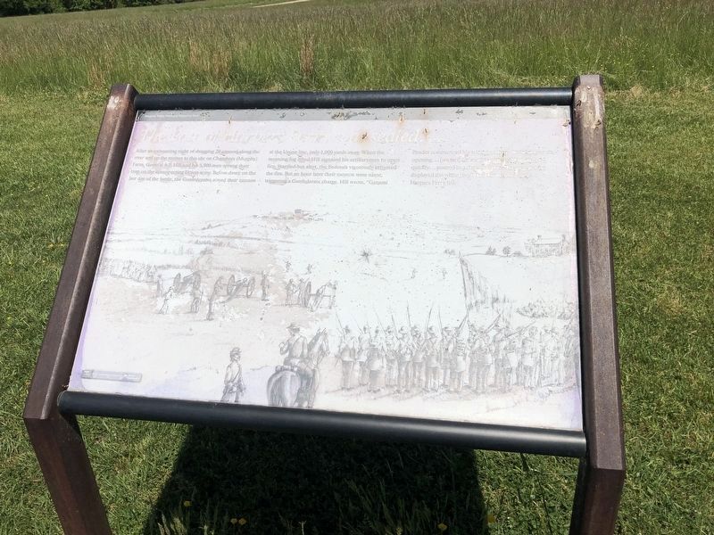
In 1862 Union soldiers forced Edmund Chambers, this farm's first owner (1848-1869), from his home. The farm became a battlefield, where Confederate General A.P. Hill struck the winning blow of the Battle of . . . — — Map (db m143933) HM
Some of the Union infantrymen who defended this ground on the night of September 14th returned the next day. Even though the Confederate strategy had won the battle for Harpers Ferry, and these Union soldiers were part of the largest surrender of . . . — — Map (db m5398) HM
This gun protected the south end of the fort and was positioned to fire on flank movements. An outside picket trench, which can be seen ahead of the main embankment, protected the artillery crew. — — Map (db m5879) HM
This memorial is dedicated to all from the Harpers Ferry-Bolivar District who served their country from World War I to the present. Their sacrifice and valor for the freedom of America will never be forgotten, for those who did not return, our . . . — — Map (db m70786) WM
(First Panel): Harpers Ferry National Historical Park is the story of... Industrial Development and the production of weapons at the Harpers Ferry armory. John Brown's Raid and his attempt to end slavery. The Civil War with Union and . . . — — Map (db m19008) HM
Surrounded by the Blue Ridge Mountains at the confluence of the Potomac and the Shenandoah Rivers, Harpers Ferry thrived as an industrial community during the first half of the 19th century. By 1860, nearly 3,000 residents lived in the . . . — — Map (db m144875) HM
"I will pledge myself that there is not a spot in the United States which combines more or greater requisites...."
George Washington May 5, 1798 Harpers Ferry's history and geography have influenced each other for . . . — — Map (db m12065) HM
Here on the scene of John Brown’s martyrdom we reconsecrate ourselves, our honor, our property to the final emancipation of the race which John Brown died to make free… Thank God for John Brown!... and all the hallowed dead who died for . . . — — Map (db m8316) HM
The Civil War affected not only the soldiers who fought but the families whose homes and towns became battlefields. Edmund H. Chambers bought this farm in 1848 and lived here with his family until the Civil War. Although Chambers was a loyal . . . — — Map (db m115283) HM
Jefferson County’s men and women have answered their nation’s call to military service in war and peace. The monument in front of you is dedicated to all our honored veterans. Five of their stories are mentioned below.
Luke Quinn,a Marine . . . — — Map (db m107894) HM
United States Marine
Killed 18 October 1859
During the capture of John Brown
Flagpole and gravesite rededicated by
Marine Corps League Detachment 1143
13 0ctober 2012 — — Map (db m104281) HM WM
Infantry troops occupied positions along these fortifications. The low height of the earth embankment at this location permitted the defending troops easy passage to and from the abatis without exposure. — — Map (db m5878) HM
As you explore Jefferson County’s Civil War sites, you will learn about some of the notable exploits on the native soil of Thomas J. “Stonewall” Jackson, one of the war's most famous figures. Jackson was born in Clarksburg, Virginia (now West . . . — — Map (db m155096) HM
Confederate Major General “Stonewall” Jackson could not see this view. His lower vantage on Schoolhouse Ridge, 1000 yards upriver, blocked his sight of this strategic position. Yet Jackson remembered this farm from his time as . . . — — Map (db m155752) HM
No soldier liked to be trapped between opposing battle lines. Here where you stand, in these open pastures about half way between the crest of Schoolhouse Ridge and the steep slopes of Bolivar Heights, was no man's land on this battlefield. . . . — — Map (db m173628) HM
In July 1896, members of the National League of Colored Women traveled here from Washington, D.C. and posed for their picture in front of John Brown’s Fort. The women came to pay homage to Brown and his raiders, establishing a pilgrimage . . . — — Map (db m8317) HM
"…make all the valleys south of the Baltimore and Ohio [rail]road a desert as high up as possible…so that crows flying over it [Virginia] for the balance of the season will have to carry their provisions with them." Lt. Gen. . . . — — Map (db m5370) HM
The Union army refused to give up. Frustrated by the Federals' stronghold on Bolivar Heights, "Stonewall" Jackson ordered cannons to the mountain tops and nearby plateaus. Pounded by a day and a morning of Confederate bombardment, Union soldiers . . . — — Map (db m148868) HM
In August 1864 Harpers Ferry was again a Union stronghold. Union General Philip Sheridan and his men built this redoubt—the earthwork in front of you—as fortification against the Confederates. Sheridan’s objective was to stop the . . . — — Map (db m5896) HM
In August 1864, Gen. U.S. Grant ordered Gen. Phillip Sheridan to construct earth fortifications on Bolivar Heights. These forts faced northwest to protect against Confederate movements down the Shenandoah Valley to Harpers Ferry. This Sheridan . . . — — Map (db m5863) HM
Liberator of Venezuela, Colombia, Ecuador
Peru, Panama and founder of Bolivia
Presented by The President of Venezuela
to Bolivar, West Virginia — — Map (db m103645) HM WM
This residence was used as headquarters by Confederate General T.J. "Stonewall" Jackson while stationed in the area during the Civil War — — Map (db m2942) HM
Consider dragging 2,000-pound cannon up this ravine—at night. General A.P. Hill’s Confederates faced that task during the second night of battle. The assignment was essential to “Stonewall” Jackson’s plan to flank the Union army on . . . — — Map (db m5889) HM
During the construction of this fort, many of the trees which were located directly in front of these embankments were felled forming an “abatis”. This timber obstruction slowed the advance of the attacking forces so that snipers, . . . — — Map (db m5872) HM
"General J.R. Jones was directed to make a demonstration against the enemy's right." Jackson's official report Confederate Colonel Edmund Pendleton wrote about the night of September 14, 1862, from his perspective across the road on School . . . — — Map (db m155727) HM
After sunset on September 14, 1862, the Confederate cannons across the road on School House Ridge vanished in the darkness. The features of the landscape began to blur as the shell-shocked Union soldiers on Bolivar Heights wondered if they could . . . — — Map (db m5394) HM
Established 1869 Alexander Murphy 1840-1931 Mollie M. Murphy 1869-1945 Mary Murphy 1834-1908 William J. Murphy 1872-1931 Historical events on the Farm: Battle of Harpers Ferry September 13-15, 1862 General Philip Sheridan's Fortification August . . . — — Map (db m13275) HM
"General Hill, charge and give them the bayonet."
Major Gen. Thomas J. "Stonewall" Jackson
September 15, 1862
Maj. Gen. A. P. Hill's division received orders from Stonewall Jackson to flank the Federal left on . . . — — Map (db m12057) HM
Union troops on the crest and slope of Bolivar Heights to the East were attacked by Confederates lead by Gen. Jackson from School House Ridge to the West on 14 Sept. 1862. Private Paylor, Co. D., 111th NY, recalled this as "an awful fight." This . . . — — Map (db m2944) HM
"We went below and formed in line of battle and laid down on our arms. Sleep was out of the question but of course, human nature will succumb and drowsiness was general among the boys. It must have been nine O'Clock or more by this . . . — — Map (db m5396) HM
"A journey of 1,000 miles begins with a single step."
Lao Tzu
The stone steps to your left are part of the Appalachian Trail - a 2,200-mile footpath from Georgia to Maine. Climb the steps to some of the most scenic . . . — — Map (db m118087)
The Small Arsenal building that stood here from 1806—1861 was one of two warehouses for the nearby United States Armory. A Harpers Ferry visitor in 1821 described both buildings as "arsenals for the deposit of arms manufactured, consisting of . . . — — Map (db m99508) HM
Hearing praise for "faithful slaves" during the dedication of the Heyward Shepherd memorial (to your left), Peal Tatten interrupted the ceremony. "I am the daughter of a [Union soldier]… who fought for the freedom of my people, who which John . . . — — Map (db m238207) HM
"The War That Ended Slavery"
Abolitionist Frederick Douglass, from his 1881 Storer College Commencement speech
"I want to free all the negroes in this [slave] state ... if the citizens interfere with me I must only burn . . . — — Map (db m143940) HM
Female students arriving here at the Cook Hall dormitory were greeted with a welcoming letter that advised them, “Here you will come as a refuge from the strangeness or perplexities of campus life. Here you will fight your battles of . . . — — Map (db m70830) HM
Harpers Ferry owed its existence principally to the United States armory, which began producing small arms here in 1801. At its height, this factory produced more than 10,000 weapons a year and employed 400 workers. The armory affected the everyday . . . — — Map (db m18793) HM
The destruction of the armory in 1861, followed by four years of Civil War, devastated Harpers Ferry's economy. Attempts at revitalization included a brewery erected here in 1895. When West Virginia enacted prohibition in 1914, the brewery . . . — — Map (db m18798) HM
The struggle of today is not altogether for today -
it is for a vast future also.
Abraham Lincoln
You are standing near what was once an international border. During the Civil War, the peak to your left lay within the Union state . . . — — Map (db m70826) HM
You are standing near what was once an international border. During the Civil War, the peak to your left lay within the Union state of Maryland. Loudoun Heights to the right was claimed by the Confederate state of Virginia. Slavery divided the . . . — — Map (db m158441) HM
You are standing directly across the street from the main entrance of one of the nation's first military industrial complexes. The U.S. Armory at Harpers Ferry, now covered by an embankment of dirt and rubble, produced the deadliest weapons of its . . . — — Map (db m24919) HM
Standing here on the night of April 18, 1861, you would have seen billowing smoke as fire raged in the armory workshops upstream. Virginia had just seceded from the United States and Virginia militiamen were advancing on the armory. Vastly . . . — — Map (db m20520) HM
The United States Armory was the main reason Lewis came to Harpers Ferry. He needed dependable weapons and supplies to succeed on his mission. The quality of the armorers' handiwork would also mean the difference between life and death for Lewis and . . . — — Map (db m20481) HM
Rank has its privileges. The paymaster, second in command at the armory, enjoyed an unobstructed view of the factory grounds and water gap from the substantial brick dwelling erected here about 1800. Soot and noise disrupted the scene with the . . . — — Map (db m18664) HM
Expanding armory operations in the opening decades of the 19th century resulted in overcrowded and unhealthy living conditions for workers. Families shared inadequate, unventilated housing, while single men slept in the workshops. To alleviate the . . . — — Map (db m18797) HM
Two brick arsenal buildings, which once housed about 100,000 weapons produced at the Harpers Ferry Armory, occupied these grounds. Capture of the firearms was the objective of John Brown’s 1859 raid. Eighteen months after Brown’s attack, the Civil . . . — — Map (db m12969) HM
Built in 1858, this house served as the home for the U.S. Armory superintendent's clerk. As an assistant to the superintendent, the clerk's responsibilities included drafting correspondence, filing reports, arranging schedules, and insuring the . . . — — Map (db m70779) HM
Passengers in the late 1800s would have instantly recognized this building as the Baltimore and Ohio (B&O) Railroad station. Known for their distinctive style and red-and-brown color scheme, the B&O designed their stations to give customers a . . . — — Map (db m70782) HM
The stone and brick walls in front of you show the outline of the Small Arsenal. The actual foundation of this former weapons storehouse lies below ground. In 1959 National Park Service archaeologists first excavated the foundation—100 years . . . — — Map (db m143937) HM
Factory officials believed a ready supply of meat for the community was "decidedly advantageous to the interests of the armory." As a result, the armory permitted local businessman Philip Coons to erect a large butcher shop and smoke-house, as well . . . — — Map (db m18792) HM
Beneath your feet lie the foundations of the Smith and Forging Shop. The largest building in the armory, it reflected changing methods of manufacturing. In the armory's early days, gun making was slow and labor intensive. Armorers worked in small . . . — — Map (db m23444) HM
You are in the Camp Hill area of Harpers Ferry. Explore Camp Hill's history with exhibits in front of the Morrell, Brackett, and Lockwood houses and Mather Training Center. Side trails in Harper Cemetery and in front of Mather Training Center . . . — — Map (db m103584) HM
Company A, 22nd New York State Militia, photographed near here during the summer of 1862. Note the house with a cannon in front of it behind the soldiers. It is still here today.
In May of 1862, during Stonewall Jackson’s Valley Campaign, Union . . . — — Map (db m158424) HM
September 15, 1862 No. 1On September 10, 1862 General R. E. Lee Commanding the Army of Northern Virginia then at Frederick Md. set three columns in motion to capture Harper’s Ferry. Maj. Gen L. McLaws with his own Division and that of Maj. Gen. . . . — — Map (db m2579) HM
September 15, 1862 No. 2 Maj. Gen. Thomas J. Jackson, with his own Division and those of Maj. Gen. A. P. Hill and R. S. Ewell, left Frederick on the morning of September 10 and passing through Middletown and Boonsboro crossed the Potomac at . . . — — Map (db m2728) HM
September 15, 1862 No. 3 Col. Dixon S. Miles, Second U. S. Infantry, commanded the Union forces at Harpers Ferry. After Gen. White joined from Martinsburg, September 12 and Col. Ford from Maryland Heights on the 13th, Miles had about 14,200 . . . — — Map (db m2914) HM
September 15, 1862 No. 4 In the afternoon of the 14th Jackson's Division advanced its left, seized commanding ground near the Potomac and established Artillery upon it. Hill's Division moved from Halltown obliquely to the right until it struck . . . — — Map (db m2921) HM
September 15, 1862 No. 5 Capture of Harpers Ferry September 15, 1862 No. 5 At daylight, September 15, three Batteries of Jackson's Division delivered a severe fire against the right of the Bolivar Heights defense. Ewell's Batteries opened from . . . — — Map (db m2922) HM
Over two dozen armory workers' dwellings, ranging from modest frame cottages to substantial stone and brick houses, once fronted Shenandoah and Hamilton streets. The wood houses disappeared around mid-century, victims of fire and demolition. The . . . — — Map (db m18799) HM
German immigrant Frederick Roeder was a prosperous baker, the father of seven children, and a recent widower. Roeder was also about to die. The Fourth of July was normally a day of celebration, but not this year - not 1861. In March Roeder buried . . . — — Map (db m99425) HM WM
The 90-foot chimney that once stood here towered over the Smith and Forging Shop, dominating the scenery from 1846 until it was torn down in the 1890s. — — Map (db m143946) HM
Once the largest building on Virginius Island, this 1848 four-story brick structure sported steam heat and gas lighting and boasted the latest machinery for making "yard-wide sheeting and shirting at less than Baltimore prices." The cotton mill . . . — — Map (db m18812) HM
The boat ramp in front of you was the site of two daring escapes in the Battle of Harpers Ferry. Under the cover of darkness, 1,400 Union cavalrymen fled on horseback down the ramp, crossing a pontoon bridge into Maryland on September 14, 1862. . . . — — Map (db m158288) HM
Situated in a gap of the Blue Ridge Mountains and at the confluence of the Shenandoah and Potomac Rivers, Harpers Ferry, from its beginning, functioned as a natural avenue of transportation.
The first mode of travel consisted of a primitive . . . — — Map (db m12058) HM
In an effort to increase the number of small arms for defense of the United States, George Washington established a Federal armory here in 1794. The rivers provided power for the machinery; surrounding mountains provided iron ore for gun barrels . . . — — Map (db m168267) HM
Waterpower built this town, and the power of the water eventually destroyed it. The destruction of the Federal Armory during the Civil War began the town's decline. Many people who had left Harpers Ferry during the war did return, only to be driven . . . — — Map (db m12982) HM
The ground around you hides the remains of the U.S. Armory at Harpers Ferry. Beneath the surface archeologists discovered walls, floors, pipes, and the base of a massive 90-foot chimney. As the team slowly and painstakingly excavated small pits . . . — — Map (db m21124) HM
Harpers Ferry, including Anthony Hall (to your left), played host to large and small scenes in the epic human struggle for freedom and equality. In this building, the superintendent of the national armory contemplated how to strengthen the . . . — — Map (db m70797) HM
Harpers Ferry, including Anthony Hall (behind you to the right), played host to large and small scenes in the epic human struggle for freedom and equality. In this building, the superintendent of the national armory contemplated how to . . . — — Map (db m70821) HM
Harpers Ferry, including Anthony Hall (to your left), played host to large and small scenes in the epic human struggle for freedom and equality. In this building, Civil War generals planned their next attack. In the fields around you, Union and . . . — — Map (db m158638) HM
Passing through this region in 1747, Robert Harper — a Pennsylvania architect contracted to build a Quaker church in the Shenandoah Valley — was so impressed by the beauty of this place and the water-power potential of the Potomac and . . . — — Map (db m10203) HM
185 entries matched your criteria. The first 100 are listed above. The final 85 ⊳