Columbus' first professional game was played on the Base Ball Grounds, located between the old Union Depot train station and High Street, on April 25, 1876. The Columbus Buckeyes defeated the famous Milfords 11-0. The Buckeyes and the International . . . — — Map (db m30026) HM
General John Hunt Morgan, CSA. On this site once stood the Ohio Penitentiary, which was built in 1834 and operated through 1984. Incarcerated here in July 1863 was Confederate General John Hunt Morgan, a cavalry commander known as the . . . — — Map (db m12966) HM
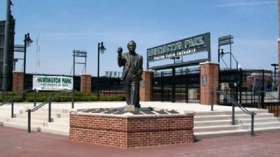
From clubhouse manager
to general manager
From Franklin County Commissioner to
International League President....
Harold's leadership and dedication to the
game of baseball uniquely qualifies him as
“The Patriarch of Columbus . . . — — Map (db m30038) HM
Central Ohio was home to Native Americans as early as 10,000 years ago. While we don't know what they called themselves, archaeologists call a group of the earliest peoples, “Mound Builders”. Their society left nearly 200 burial and . . . — — Map (db m30023) HM
After sitting dormant for six years, Jet Stadium was refurbished as Franklin County Stadium. The park was the first minor league facility to have Astroturf and roof suites. In 1984 the stadium was renamed Cooper Stadium in honor of former Franklin . . . — — Map (db m30036) HM
Columbus' first major league club played their home games at Recreation Park located at the intersection of Mound Street and Parsons Avenue. The park was one of the first in the country to have both a grass infield and a grass outfield. Columbus' . . . — — Map (db m30028) HM
The Senators played their home games at Neil Park at the corner of Cleveland and Buckingham Avenues. The wooden structure was replaced in 1905 with the first concrete and steel stadium. Cleveland and Detroit played home games at Neil Park to avoid . . . — — Map (db m30032) HM
[Marker Front]:
Thousands of Irish immigrants came to Columbus to seek personal and religious freedom. With the "Great Hunger" in Ireland and the completion of the Ohio and Erie Canal and the National Road, immigration to Columbus increased . . . — — Map (db m12963) HM
After the 1954 season, the Cardinals moved the Red Birds to Omaha. For the first time in the 20th century Columbus was temporarily without a baseball team. Eleven Columbus businessmen put up $10,000 each and in January, 1955, Harold Cooper . . . — — Map (db m30035) HM
Columbus' Negro League teams were the Black Tourists (1900, 1908), the Buckeyes (1921), the Keystones (1930), the Turfs (1932), the Blue Birds (1933), and the Elite Giants (1935). Most Columbus Negro League home games were played at Neil Park. . . . — — Map (db m30031) HM
Columbus entered the railroad era on February 20, 1850 when owners William Neil and Alfred Kelley brought the first trains on the Columbus and Xenia Railroad, spanning the Scioto River with a wooden trestle. The line provided service from Columbus . . . — — Map (db m30024) HM
After the 1930 season, the St. Louis Cardinals bought the Columbus Senators and changed the team's name to the Red Birds. In 1932, Red Bird Stadium was built on West Mound Street. It was one of the first stadiums in the country built with lights . . . — — Map (db m30034) HM
The 1892 Columbus Reds won the city's first pennant as a member of the Western League. Columbus rejoined the league as the Senators from 1896-99. The Senators played their home games at Western League Park at Parsons and Jenkins Avenues. The league . . . — — Map (db m30030) HM
Columbus was founded specifically for the purpose of being the state capital in 1812, and was selected primarily due to its location - near the center of the state. But a lack of transportation options restricted access to town. For nearly 20 . . . — — Map (db m30007) HM
Along the western edge of what is now the Grange Insurance Audubon Center stands a string of old trees,
planted during the days of industrial use on the site. Long before the first spade of dirt was turned to build it,
the Center’s first . . . — — Map (db m209581) HM
The German Seminary of the Evangelical Lutheran Synod of Ohio, the first Lutheran theological seminary west of the Appalachian Mountains, began instruction under Pastor Wilhelm Schmidt in Canton in 1830. The seminary relocated to Columbus at this . . . — — Map (db m80014) HM
Columbus Main Library. The first tax supported free public library in Columbus was formed in 1873 and housed in City Hall. In 1901, City Librarian John Pugh petitioned Andrew Carnegie for funding and was granted $200,000. In 1903, the Swayne . . . — — Map (db m12927) HM
This ten acre site was purchased in 1829 for the Ohio School for the Education of the Deaf. The first school building opened here in 1834; the school was enlarged in 1845. In 1868 the original school was replaced. Another school building was added . . . — — Map (db m12934) HM
A landscape interpretation of Georges Seurat's benchmark post-impressionist painting, rendered in scupted yews. If you stand to the left of this sign you will see the scene as Seurat saw it in Paris in 1886. — — Map (db m201040) HM
Donn Vickers served as the executive director of the Thurber House from 1985 through 2001. As executive director, Donn was responsible for many accomplishments including the development of Thurber Park and the construction of this gazebo.
In . . . — — Map (db m14499) HM
Elijah Pierce (1892-1984) was an internationally recognized woodcarver/folk artist. Mr. Pierce began carving wood as a young boy on the Baldwyn, Mississippi, farm where he was born in 1892. In the early 1920s, he carved a small elephant for his wife . . . — — Map (db m16966) HM
George Bellows. George Bellows (1882-1925) is widely recognized as one of America's premier artists. His vivid portrayals of modern urban life have become indelible icons of American art. Born and reared in Columbus, he retained close ties . . . — — Map (db m221445) HM
He preserved for posterity the story
of the brave men and women who founded
this great state. He traveled Ohio in
1846 and again in 1886 and twice published his
Howe’s Historical Collections of Ohio — — Map (db m98741) HM
One of the outstanding American humorists of the twentieth century, James Thurber was born and educated in Columbus. He launched his writing career as a reporter for The Columbus Dispatch in 1920. In 1927 he began writing for The New . . . — — Map (db m14498) HM
When Fernando Cortez and Sophia Stone Kelton built this house in 1852, it was the last residence on East Town Street and was surrounded by pastureland. Ardent abolitionists, the Keltons were members of the local antislavery society. Family . . . — — Map (db m42170) HM
Philip T. Snowden, owner of a fancy dry goods and millinery, built the Italianate-style residence at 530 East Town Street in 1852. The house was part of the fashionable University Place addition on the east side of the city. From 1862-1864 Ohio's . . . — — Map (db m94242) HM
Side A:St. Patrick Church
Built in 1852 and dedicated a year later, St. Patrick Church is the second oldest Roman Catholic Church in Columbus. Founded as the English speaking parish, this church of Norman Gothic design served as the home . . . — — Map (db m17474) HM
The Topiary Garden, begun in 1989 by the Columbus Recreation and Parks Department, is a recreation in sculpted shrubbery (topiary) of French artist Georges Seurat's famous painting, “A Sunday Afternoon On The Ile De La Grande Jatte” . . . — — Map (db m13050) HM
As an early advocate of social justice, the Rev. Dr. Washington Gladden led local and national causes for civil rights, workers' rights, voting rights, religious pluralism, school integration, and the needs of the poor and the oppressed.
The . . . — — Map (db m201044) HM
This site was
formerly occupied by the
Wesley Chapel
Methodist Church
and its successor
Central
Methodist Church
merged with
Broad Street Methodist Church
October 1935 — — Map (db m98928) HM
Miss Caroline Louise Frankenberg (1806- 1882)
brought the kindergarten concept from Germany to
Columbus in 1836. She returned to Germany for
further study, then established the school at the
S.E. corner of Rich and Pearl Alley in 1858.
The . . . — — Map (db m94247) HM
On this site, December 10, 1886, the Federation of Organized
Trades and Labor Union merged with trade unionists of the
Knights of Labor to create the American Federation of Labor
Delegates elected Samuel Gompers president and dedicated
the . . . — — Map (db m220825) HM
American Federation of Labor
Since 1881
One this site, December 10, 1886, the Federation of Organized Trades and Labor Union merged with the trade unionists of the Knights of Labor to create the American Federation of Labor. Delegates elected . . . — — Map (db m214646) HM
The members of the Central Ohio Labor Council. AFL-CIO,
Dedicate this Monument
to the 29 miners in the disaster on April 5, 2010,
at the upper Big Branch Coal Mines
Montcoal, West Virginia
Rest In Peace Brothers
Carl Acord 52 •
Jason . . . — — Map (db m203897) HM
On the evening of September 29, 1899, thirteen recently returned veterans of the Spanish-American War met in a tailor shop that once stood on this site. These men, all veterans of the Columbus-based 17th Infantry Regiment that had fought in Cuba, . . . — — Map (db m94562) HM
The Broad Street bridge is a significant part of the history of Columbus and the National Road. Until 1816, the only ways to cross the Scioto River were to ford the river during low water or to use the ferry. From 1816 to 1834 a series of wooden . . . — — Map (db m96392) HM
Arthur Boke Jr was the first African-American resident of Franklinton, Ohio. His story tells far more than the color of his skin. It is a story of love, selflessness, compassion, and understanding expressed by Sarah Sullivant. Her example reaches . . . — — Map (db m35302) HM
On the west bank of the Scioto River stands the former Central High School, now the core building of the Center of Science and Industry (COSI). The Plan of the City of Columbus, released in 1908, was developed to create a vision for the city in line . . . — — Map (db m96393) HM
The historic district extends from the former Main Street Bridge to Long Street and encompasses the public buildings on either side of the Scioto River. The 580 foot long low-head concrete arch Main Street Dam was constructed in 1918 in response to . . . — — Map (db m107780) HM
Is the first park developed specifically to honor Ohio's public educators. It was created by members and friends of the State Teachers Retirement System of Ohio as part of the system's 80th anniversary celebration. Included in the park are the names . . . — — Map (db m14491) HM
A Brief History:
At over 231 miles long, the Scioto River bisects half the longitude of the State of Ohio The river has historically served as fertile hunting grounds for several Native American tribes a navigational tool for European . . . — — Map (db m203903) HM
Side A
Johann Christian Heyl (1788-1877), the first German and first Lutheran to settle in Columbus, was one of the original 15 settlers of the city. A baker by trade, Heyl came to bake for the soldiers quartered in Franklinton during the . . . — — Map (db m94617) HM
On this spot the first cabin
in Columbus
was built by its first inhabitant
John Brickell 1797
Born Stewarts Crossing, Penn. 1781.
Captured by a Delaware Indian 1791.
Adopted by chief of that tribe
Whingwy . . . — — Map (db m59319) HM
The King Lincoln District was established in July 2002 to honor the historic heart and soul of Columbus’ African American community. This arch, welcoming all to the King Lincoln District, is dedicated to our shared history and our commitment to the . . . — — Map (db m16965) HM
In 1992, the national floral show known as Ameriflora came to Columbus and was featured at Franklin Park on the near east side. The Central Ohio AFL-CIO incorporated an area of the park to honor workers killed in the work Place. A small grove of . . . — — Map (db m203904) HM
This site was the location of a children's park and fountain, dedicated in 1992, made possible with major contributions from members of the builders exchange of central Ohio and individual donors whose names were memorialized on bronze plaques. . . . — — Map (db m203884) HM
Named and Dedicated Oct. 31-1921
by Columbus Camp No. 49
United Spanish War Veterans
to the memory of all persons
from Franklin County who
served in the World War — — Map (db m31393) HM
This Memorial Garden is a sanctuary for remembrance and reflection.
A grove of American Elms, a tree which has sheltered veterans and their families since colonial times, provides a place for rest and relaxation.
The limestone wall . . . — — Map (db m201037) WM
Author's Note:
It is wise to remember the ancient people before us who greeted new things to this continent. How did they teach children to prepare for real change holding to virtue as they discovered the voyagers? The hero of this fantasy, . . . — — Map (db m204180) HM
My stone is red for
The blood they shed
The medal I bear
Is my country's way
To show they care.
If I could be seen
By all mankind
Maybe peace will
Come in my . . . — — Map (db m201038) WM
On this site, the Scioto River has been spanned by at least six bridges, all of which have been important to the growth of Columbus, Ohio's state capital.
1816 • A wooden toll bridge was built by Franklinton developer Lucas Sullivant.
1826 • . . . — — Map (db m31427) HM
Dave Thomas realized his boyhood dream when he opened his first hamburger restaurant on this site on November 15, 1969. Thomas changed the image of fast food by serving fresh, not frozen hamburgers, hot off the grill with a choice of toppings in a . . . — — Map (db m14492) HM
Our debt to the heroic men and the valiant women in the service of our country can never be repaid. They have earned our undying gratitude. America will never forget their sacrifices.
- Harry S. Truman — — Map (db m201039) WM
St. Joseph Cathedral
November 11, 1866, the cornerstone
of St. Joseph Cathedral was laid at the
N.W. corner of E. Broad and 5th Sts. The
beautiful gothic structure was
completed n 1872. The consecration
service took place October 20, 1878,
a . . . — — Map (db m98924) HM
Organized in 1823 as Bethel African Methodist Episcopal Church, St. Paul A.M.E. Church is the oldest congregation of African descent in Columbus. The church, founded by Moses Freeman and 13 other members from the Town Street Church, was originally . . . — — Map (db m16963) HM
This site, now Grant Medical Center, was the original location of the neo-gothic building that housed St. Francis Hospital and Starling Medical College, named for Columbus benefactor Lyne Starling. Established in 1849, Starling Medical College/St. . . . — — Map (db m12926) HM
"Fireproof" was an important word to the Columbus business community. Between 1889 and 1893, five downtown Columbus theaters were constructed and destroyed by fire. These fires also claimed the Seneca, Deshler, and Vendome hotels and resulted . . . — — Map (db m203909) HM
Construction began December 1930 in the administration of Governor Meyers Y. Cooper and was completed February 1932 in the administration of Governor George White.
This site was chosen and this building erected by the Ohio State Office . . . — — Map (db m214653) HM
The confluence of the Scioto and Olentangy Rivers is just northwest of North Bank Park, and the rivers were the major attraction for both Native American and white settlers. The river and its tributaries were the life-blood to the region providing . . . — — Map (db m29966) HM
Toledo and Ohio Central Railroad Station
The only remaining Columbus railroad station, The Toledo & Ohio Central (T&OC) Railroad Station was constructed in 1895 and was the departure point for William McKinley when he left for Washington D.C to . . . — — Map (db m13067) HM
The second Town Street Bridge, a closed spandrel concrete arch bridge,
crossed the Scioto River at this location from 1921 to 2009. The bridge
was designed by the firm of Braun, Fleming and Knollman, and was built
by the D. W. McGrath and Sons . . . — — Map (db m107965) HM
William Neil and his wife Hannah Schwing Neil each played significant roles in the early development of Columbus.
William was a large, outgoing, and ambitious man determined to make a fortune. His first successful business was a tavern on High . . . — — Map (db m29957) HM
William Green Labor Leader
A native of Coshocton County, William Green (1870-1932) began his working life as a coal miner at age 16 and rose rapidly in the leadership of the United Mine Workers of America. Twice elected to the Ohio Senate, . . . — — Map (db m12970) HM
The history of a city is found not only in its grand old houses, but also in its neighborhoods. While Columbus has its share of grand houses, most residents did not live that lifestyle. Many working class people lived in hotels, apartments, . . . — — Map (db m30002) HM
Jacob Overdier
Harrison House
570 West Broad Street
built circa 1807
General William
Henry Harrison's
troops stayed in this
House during the
War of 1812.
Sullivant Land
Office
Behind . . . — — Map (db m93686) HM
The Italian Community gratefully remembers
Father Rocco Petrarca
Pastor of
St. John the Baptist Church
from 1913 to 1948
“Flos Memoriae Lapide Perennior” — — Map (db m14489) HM
Reverend Father Alexander Cestelli. The National Italian Catholic parish of Saint John the Baptist was founded in October 1896 by the Reverend Father Alexander Cestelli, D.D. Father Cestelli was born in Fiesole, Italy and came to America in . . . — — Map (db m14487) HM
Bryden Road is named after James Bryden, a city councilman and county commissioner who owned 135 acres here in the 1840's. By 1900 Bryden Road was known for its stately homes, canopy of elms, and the electrically lit metal arch at its west entrance. . . . — — Map (db m17182) HM
This nine acres of land was purchased by the citizens of Columbus in 1837, and deeded to the state for use as the Ohio School for the Blind. The first building, designed by N. B. Kelly and occupied in October 1839, was replaced by the current . . . — — Map (db m17178) HM
This cast-bronze eagle once adorned the
Battleship U.S.S. Ohio
Restoration has been made possible through
donations by
five Columbus Women’s Service Clubs
Altrusa Club • Quota Club
Pilot Club • Zonta Club
Soroptimist . . . — — Map (db m88248) HM
(side A)
Columbus Feeder Canal
Col. Nathaniel McLean removed the first earth for the Columbus Feeder Canal not far from this site, April 27, 1827. The earth was wheeled away by Ralph Osborn and Henry Brown, auditor and . . . — — Map (db m88254) HM
Once the headquarters of the Julian & Kokenge Co. which was founded by future United States Treasurer, William A. Julian in 1893. The company would steadily grow into one of the largest manufacturers of women's shoes in the nation, and a . . . — — Map (db m203907) HM
The bioretention basins in this area along Town, Front, Rich, and Main Streets were installed during three roadway projects from 2008 to 2011 as part of Mayor Michael B. Coleman's Green Columbus Initiative. A bioretention basin is a landscaped area . . . — — Map (db m203906) HM
The Austrian Oak won the Mr. World Professional Body Building Contest at Veterans Memorial Auditorium in September 1970. He also won another 13 world bodybuilding championships. Gaining worldwide fame as an action film star, he was Businessman, . . . — — Map (db m201034) HM
When Dr. Lincoln Goodale presented it to the city in 1851, Goodale Park was nothing more than forty acres of woods.
Today the park is the epicenter of the Short North Arts District’s biggest events, one of the unequaled public spaces in . . . — — Map (db m211052) HM
HighBall is the nation’s fiercest costume party. Staged in the fashion capital of Columbus, this yearly event for the Halloween season bridged runway style with the culture of the Short North Arts District. Be a part of the HighBall street spectacle . . . — — Map (db m210941) HM
One of five Civil War military posts in Columbus, Tod Barracks, named in honor of Governor David Tod, was built in 1863 as the headquarters for military administration in central Ohio. Necessitated by Lincoln’s call for 300,000 new troops, the . . . — — Map (db m9834) HM
The Grand Union Station and its ornate arcade was the third and final train
station to occupy the spot where the Columbus Convention Center now
stands. Designed by celebrated architect Daniel H. Burnham, it
featured the Grand Concourse which . . . — — Map (db m211386) HM
Dedicated in honor of
the Grand Army
of the Republic
by the
National Organization
Daughters of Union Veterans
of the Civil War 1861-1865 — — Map (db m203791) WM
General Ulysses S. Grant • General Philip Sheridan • Edwin M. Stanton • James A. Garfield • Rutherford B. Hayes • Salmon P. Chase • General William T. Sherman — — Map (db m9895) HM
Inside Billy Leachman's Chophouse
on a cold day in December,
George Baker, Harry Shunk
and C.C. Philbrick
(publisher of THE OHIO SUN)
worried about how the
needy children of the area
would keep warm during the winter.
Inspired by . . . — — Map (db m35458) HM
Construction of old City Hall on this site was begun in 1869 and completed in 1872 at a cost of $175,000. The 140-foot high building of Gothic design contained dark cream Amherst stone and was one of the prominent landmarks of its day. First floor . . . — — Map (db m80009) HM
Christopher Columbus, an Italian navigator, launched four voyages of discovery to the new world.
1492. The spirit of discovery has the power to change the course of human history as demonstrated by the voyages of Christopher Columbus, . . . — — Map (db m9846) HM
When it was completed in 1887, this building was the first federal district courthouse and post office specifically built for those purposes in the city. A magnificent example of the Romanesque Revival style, the building was more than doubled in . . . — — Map (db m35457) HM
At the invitation of the citizens of Columbus, Ohio, Abraham Lincoln delivered a memorable address here on the sixteenth day of September, eighteen hundred fifty nine.
This commemorative marker was erected on the 75th anniversary of that event . . . — — Map (db m36901) HM
On January 2, 1866, Pelatiah Webster Huntington opened his bank at the heart of the Columbus community - the intersection of Broad and High Streets. Since that date, the Huntington National Bank has been committed to serving the people of central . . . — — Map (db m35462) HM
He served as Governor for 16 years—longer than any other state governor in the history of the Union.
Governor of the State of Ohio, 1975–1983, 1963–1971 • Auditor of the State of Ohio, 1953–1963 • Major of the City of . . . — — Map (db m88644) HM
This tree was bud-grafted from the last standing
revolutionary-era liberty tree. These trees served as
gathering places for American Colonists fighting for
their independence. May this tree serve as a living
testimony to our American founding . . . — — Map (db m203418) HM
Ohio in the Civil War. With five army camps in Columbus, Capitol Square was a military crossroads from 1861 to 1865. Ohio troops were mustered, paid, and on some occasions garrisoned at the Statehouse. Three of every five male Ohioans between . . . — — Map (db m9840) HM
Ohio State House
has been designated a
National Historic Landmark
This site possesses national significance
in commemorating the history of the
United States of America 1978
Heritage Conservation and Recreation Service . . . — — Map (db m131038) HM
On January 26, 1838, the Ohio General Assembly passed an act “providing for the erection of a new statehouse.” Construction of the Greek revival, 184 – by 304 – foot structure began in the Spring of 1839, and on July 4 of . . . — — Map (db m131034) HM
129 entries matched your criteria. The first 100 are listed above. The final 29 ⊳