Allen County was created on April 1, 1824, by a
December 1823 act of the Indiana General Assembly.
The newly created county was named for Col. John
Allen of the Kentucky militia who had helped relieve
the siege of Fort Wayne in 1812 and who was . . . — — Map (db m197324) HM
Fort Wayne business had a start on Duck Street, named for the 19th century Duck Creek that drained the area from the higher ground near Superior Street into the St. Mary’s River. Along Duck Creek in the 1840s and 50s stood the City Mills, one of the . . . — — Map (db m16997) HM
The Wabash & Erie Canal was instrumental in the construction of the first railways in Fort Wayne, which quickly became a railroading center in the Midwest. In 1852, along the canal at the present-day railroad elevation that borders the south edge of . . . — — Map (db m16996) HM
Around the turn of the century, the nationwide “City Beautiful” movement found local expression through the efforts of Charles Mulford Robinson and nationally known landscape architect George Kessler. Seeking to reclaim the natural beauty of our . . . — — Map (db m17034) HM
Old fort near this point was site of first Masonic meetings in northern Indiana, early spring 1823, leading in October to original Wayne Lodge No. 25, ancestor of present Lodge of same name and number. — — Map (db m213792) HM
She encouraged local efforts to form First Presbyterian Church, establish a public library, support the national Women's Suffrage Movement, and donated land for Fort Wayne's first African-American church.
The Hamilton Estate on Clinton Street . . . — — Map (db m16967) HM
The confluence area of the Three Rivers was known to the native people since as early as the end of the last Ice Age, more than 10,000 years ago. As the glaciers melted and receded, they paused here creating a high point in the topography of the . . . — — Map (db m17064) HM
Methodism in Fort Wayne
area originated with the
establishment of a mission
in 1828.
Changed to Berry Street
Chapel in 1840.
Divided into First and
Wayne Street Churches
in 1849.
Reunited in 1968. — — Map (db m197284) HM
The concrete retention walls at the north end of the plaza will help downtown Fort Wayne withstand future flooding when the rivers rise. They were constructed where sandbaggers and volunteers worked during the flood of 1982 to build a dike to . . . — — Map (db m17061) HM
Architect Eric R. Kuhne was commissioned to design a flood control plan that would provide for a park and premier festival center. It could also serve as a model for flood control in other sections of the country. The Headwaters Park Commission was . . . — — Map (db m17037) HM
Headwaters Park has been created by the citizens of Fort Wayne through their donations, ideas, and labor as a means of flood control in the city. Earlier designs had a similar purpose. George Kessler's plan of 1912 envisioned a greenspace for . . . — — Map (db m197058) HM
Because of the often soggy conditions that discouraged use as either residential or commercial property, the area of Headwaters Park became known as the Jail Flats. The first jail in Allen County was a two-story hewn-log structure that was enclosed . . . — — Map (db m197061) HM
The first professional organized league baseball game was played here on May 4, 1871 ending in a victory for the Fort Wayne Kekiongas over the Cleveland Forest Citys by a score of 2-0. A wooden structure was built in 1883 and rebuilt numerous times . . . — — Map (db m59686) HM
Miami Chief Mishikinakwa or Me-she-kin-no-quah, known to the Euro-Americans as Little Turtle, born circa 1747, played a significant role in the settlement of the area surrounding the confluence of the Three Rivers. He was the most successful Native . . . — — Map (db m197057) HM
In the early 1790s, the United States Army suffered two serious defeats at the hands of Indians under the leadership of Little Turtle, war chief of the Miami nation. In response, President George Washington sent Revolutionary War hero Gen. . . . — — Map (db m119973) HM
Only land barrier
on shortest trade route
between Quebec and
New Orleans.
Eastern landing of eight-
mile carry from St. Mary's
to Little River. Used by
Indians, French, British
and American traders. — — Map (db m21061) HM
Long before settlers appeared on the scene, the American Indian people here used the sandhill crane as a symbol for their tribe. Early British and American officials referred to the people we know as Miami as “Twightwees” in various . . . — — Map (db m17068) HM
The first Fort Wayne home of Mrs. Eliza E. George was near this spot. At the age of 54 she helped make Civil War nursing history. Mother George, as she was known to thousands of Union soldiers, served with front line troops in Mississippi, . . . — — Map (db m44085) HM
South Clinton Street gained notoriety as a Depression era "Shanty town.” The "hobo
heaven” or "hobo jungle” that sprang up on the "Jail Flats” became home to hundreds
of families at its peak in 1933, filling the area with tarpaper shacks and smoke . . . — — Map (db m197137) HM
Organized by Rev. Jesse Hoover on October 14, 1837, with a congregation of 24 families, it was the first Lutheran church in the Fort Wayne area. A school was organized by Rev. Hoover the same year. Originally known as the First Evangelical Lutheran . . . — — Map (db m162795) HM
The Barr Street Market is the oldest
market in Fort Wayne. The land was
donated to the city by Samuel Hanna in
1837, and within six months a small
frame market house was built; merchants
rented stalls for $5 per year.
and the market were named . . . — — Map (db m197286) HM
During Fort Wayne's 1994 Bicentennial Celebration, this walking trail of
selected major sites in Fort Wayne's
history was developed as a Lasting Legacy
to the City with grants from the Journal-
Gazette Foundation, Essex Group, Inc.,
and Witwer . . . — — Map (db m197316) HM
The concrete retention walls at the north end of the
plaza will help downtown Fort Wayne withstand future
flooding when the rivers rise. They were constructed
where sandbaggers and volunteers worked during the
flood of 1982 to build a dike to . . . — — Map (db m197138) HM
Designed by Fort Wayne architects John Wing and Marshall Mahurin, the Elektron Building was built in 1895. The name Elektron inscribed on the cornice at the top of the building reflected the business interests in early electrical engineering of the . . . — — Map (db m162797) HM
1863 marked the beginning of the first organized Police Force in the city. The council named a captain and three patrolmen to serve from twilight to daybreak. On this site was located the first city Police Station. It contained three iron cages on . . . — — Map (db m44086) HM
Most often the rivers here brought prosperity. They are the reason humanbeings settled here; established a land portage to connect with the Wabash River system; and attracted the canal followed by rails, highways, industry, and homes. They brought . . . — — Map (db m17030) HM
The French built Fort St. Philippe (Fort Miamis) west of this area by 1722, to command the land portage here between the Maumee and Wabash Rivers. It was important to the French to protect the area in their political competition with the British as . . . — — Map (db m17067) HM
Construction of the Lincoln Tower began less than
a month before the stock market crash of October
1929 that signaled the beginning of the Great Depression. Completed in November 1930, the 312-foot
Tower was for many years Indiana's tallest . . . — — Map (db m197233) HM
The News-Sentinel Building was constructed in
1925 by Oscar Foellinger, the publisher of the Fort
Wayne News-Sentinel.
The News Sentinel traces its history to the first
newspaper in Fort Wayne, The Sentinel, which began
publication as a . . . — — Map (db m197287) HM
In 1880, the New York, Chicago, and St. Louis
Railroad, known commonly as "The Nickel Plate
Road,” purchased from the Wabash & Erie Canal the
right-of-way through central Fort Wayne. The
construction of the railroad on the site of the old . . . — — Map (db m197329) HM
The Fort Wayne City Building, later called "The
Old City Hall,” was designed by local architects John
Wing and Marshall Mahurin and was dedicated on
April 20, 1893, by Mayor Charles Zollinger.
Called by some "The Hapsburg Horror” as a . . . — — Map (db m197283) HM
Past this point flowed the Wabash and
Erie Canal begun at Fort Wayne in 1832
rad dedicated at Fort Wayne July 4, 1843.
m its final phase the canal ran from
Maumee Bay on Lake Erie, through
Fort Wayne and southwestward to
Lafayette and thence . . . — — Map (db m197327) HM
Edith (seated), scholar of Greek and Roman mythology, wrote the classic text, The Greek Way.
Alice (standing), Edith's sister, influential industrial physician, advanced the reform of unsafe working conditions in our nation's factories. . . . — — Map (db m16956) HM
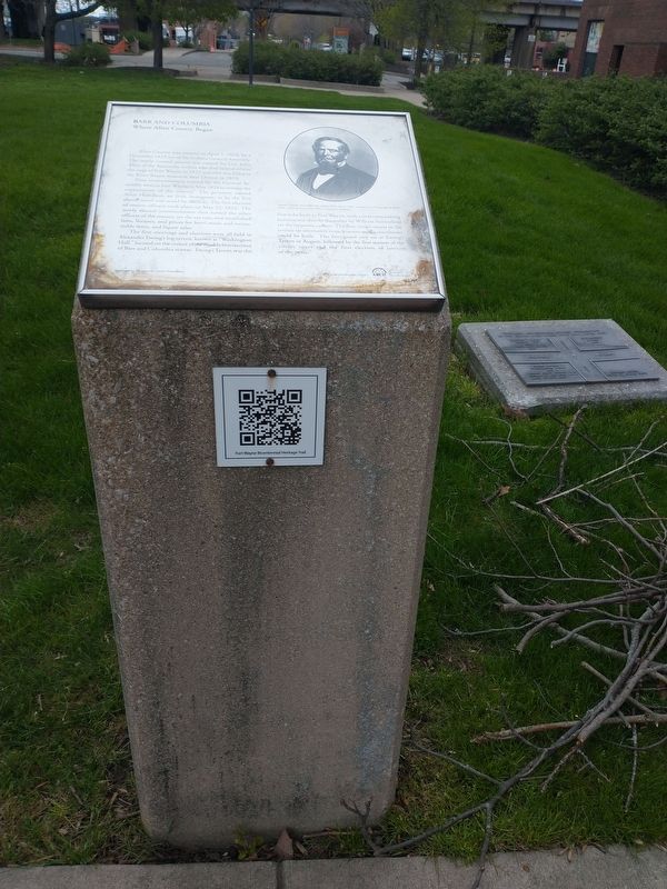
This Barr and Columbia Street intersection is the center from which Civic Fort Wayne Grew
North West
Barnett-Hanna Trading Post 1819
First Post Office 1820
North East
Suttenfield Tavern 1823
South West . . . — — Map (db m197325) HM
This YMCA logo, established in the late 1800's combined the YMCA's Christian emphasis
with an equilateral triangle which stood for man's essential spirit, mind and body.
John 17:21 That all of them may be one, Father, just . . . — — Map (db m197197) HM
The first volunteer fire company was founded in Fort Wayne in
1839. On this site in 1860 was located the first Central Fire
House. This two story brick structure with a bell tower housed
two steam fire engines and two hose wagons. The units . . . — — Map (db m239331) HM
The "Old Well," an important factor in the existence of the fort and its people, saved the fort from Indian fire brands in 1812. Fort Wayne was first built, near by, in 1794. It was rebuilt, on this site, in 1804, and 1815.
Research by . . . — — Map (db m21210) HM
Terminal point where French-Canadian boats, hollowed from 30-60 foot poplar logs, brought families and cargo up the Maumee River from Toledo and Detroit, and returned furs to Lake Erie in exchange for traders' supplies, from the late 1700's until . . . — — Map (db m16957) HM
This 2000 pound bell costing $1000,00. was manufactured by the Jones and Company Foundry, Troy, New York. It was placed in Fire Station Number 1 at the corner of Court and Berry Streets in 1867 a new Number 1 Fire Station was constructed in 1893 . . . — — Map (db m239332) HM
The Last Two American Forts
In 1798, Col. Thomas Hunt began construction on this site of the second American fort at the Three Rivers. this fort, which was completed in 1800, replaced the first, hastily built one erected nearby to the . . . — — Map (db m21219) HM
It was the first United States fort near "Three Rivers". This fort commanded the shortest portage between the St. Lawrence and Mississippi systems a portage known to the Indians as "Glorious Gate" and a strategic cross-roads in early trade and . . . — — Map (db m21020) HM
Memorial Park
Neighborhood Association
lasting legacy
for the Fort Wayne
bicentennial celebration
August 1994
A Memorial Tribute
to Past, Present and
Future Veterans of
Allen County, Indiana
In this monument, during this
the . . . — — Map (db m197331) WM
Erected in memory of Arthur R Smith Pioneer aviator who gave his life in U.S. Air Mail Service
By the citizens of Fort Wayne A.D. 1926 — — Map (db m197333) HM
Harold T. Adams •
William H. Ahrens •
Spencer T. Alden •
Horace W. Barnes •
Charles Baron •
Russell C. Barrett •
Lansing Behrman •
John C. Berry •
Edward Bethner •
Walter G Betz •
Samuel Bibo •
Leo J, Boaeuf •
Albert B. Board . . . — — Map (db m197332) WM
To the Memory of
Major John Wyllys
And His Brave Soldiers Who
Were Killed Near this Spot
In The Battle of
Harmar's Ford
Oct. 22, 1790
With the Indians Under
Chief Little Turtle — — Map (db m21358) HM
Anchoring the southern edge of the Headwaters Park “Thumb” until circa 1874, the Wabash & Erie Canal’s importance to transportation to the western part of the United States and to the growth of Fort Wayne was substantial. Headwaters Park . . . — — Map (db m16985) HM
A capsule was buried on this site on May 11, 2002 when citizens of Takaoka and Fort Wayne met to re-affirm an alliance established in 1977. The capsule, containing articles related to the 25th anniversary, will be opened on the occasion of the . . . — — Map (db m239279) HM
Born in Massachusetts, 1776
Died near Fort Wayne, 1843.
Buried in the David Archer Cemetery
Pioneer apple grower of Indiana and Ohio.
The Indiana Horticultural Society
and all those who are endeavoring to carry
on the work he nobly commenced . . . — — Map (db m59649) HM
Abraham Lincoln Came to Indiana in 1816 when but seven years old. Upon becoming of age in 1830 he migrated to Illinois. This statue by Paul Manship portrays Abraham Lincoln as a Hoosier youth. — — Map (db m162800) HM
9 January 1865. Patrick H. Keegan sold this half-lot to carpenter James C. Dillon who built a frame, one, and one-half story house.
28 June 1889. His three daughters sold this house to Patrick H. Keegan.
21 April 1914. Mr. . . . — — Map (db m197188) HM
In this house on October 6, 1908, was born Jane Alice Peters. Daughter of Frederick C. and Elizabeth Knight Peters, she took the professional name of Carole Lombard and became one of the most important figures in the motion picture industry. . . . — — Map (db m109155) HM
Oldest church structure in continuous use in Fort Wayne area and seat of Catholicism in northern Indiana.
Christianity carried to this part of the New World in 1600's by Catholic missionaries. Land formerly part of burial ground for Miami . . . — — Map (db m45024) HM
For nearly a century, the principal
business street of Fort Wayne, named for
Dana Columbia, hotel and canal boat operator.
Here was the terminal for passengers
and freight arriving and departing via
stagecoach and canal. Ground broken
for . . . — — Map (db m197141) HM
Fire Station #3
226 W. Washington Blvd
has been placed on the
National Register
of Historic Places
by the United States
Department of the Interior
c. 1893 — — Map (db m197147) HM
The first Presbyterian minister to conduct services at Fort Wayne was the Rev. Matthew Wallace, an Ohio pastor who served as chaplain to the army under General William Henry Harrison during the War of 1812 and accompanied the troops in the relief . . . — — Map (db m197192) HM
French built a palisaded fort on this strategic site in 1722; named Fort Saint Philippe des Miamis. One of three French forts built in what is now Indiana to protect French fur trade from encroaching English. First of five forts built over time . . . — — Map (db m241261) HM
Fort Wayne
Printing Building
c. 1911
has been placed on the
National Register
of Historic Places
by the United States
Department of the Interior — — Map (db m197146) HM
“Well done, good and faithful servant.”
(Ft. Wayne Chamber of Commerce – Jan. 7, 2927)
J.B. Franke dedicated his lift to service of others. He donated 80 acres to the City of Fort Wayne, which is now known as Franke park. Mr. . . . — — Map (db m119974) HM
Kresge-Groth
Building
c. 1926
has been placed on the
National Register
of Historic Places
by the United States
Department of the Interior — — Map (db m197144) HM
Louis Mohr Block
has been placed on the
National Register
of Historic Places
by the United States
Department of the Interior
Built 1891 — — Map (db m197195) HM
The Aqueduct
Carrying the Wabash and Erie Canal across the St. Marys River was located just north of the bridge about where the Nickle Plate Railroad crosses the river and was the playground and swimminghole for the West End Boys. Completed . . . — — Map (db m99093) HM
Commandants 1680-1697; Jean Baptiste Vissat, Sieur DeVincnnes, Francois-Margane, Sieur DeVincennes. 1725; Ensign Douville,. 1734; Ensign DuBuison.
In 1747, savages burned the fort but it was rebuilt. M. DeRaimond was commandant in 1748.
. . . — — Map (db m232369) HM
Schmitz Block
c. 1888
has been placed on the
National Register
of Historic Places
by the United States
Department of the Interior — — Map (db m197145) HM
Established in 1846 as the Fort Wayne Female College on grounds donated by Wm. Rockhill.
In 1855 the college consolidated with the Fort Wayne Collegiate Institute for Young Men and it was then call the M.E. College.
In 1890 the college grounds . . . — — Map (db m100138) HM
St. Mother Theodore Guerin founded the first
catholic school in Fort Wayne on this site
in 1846. Her community, The Sisters of
Providence, taught young people of
Fort Wayne for over 125 years. She was canonized
a Saint October 15, 2006
. . . — — Map (db m197229) HM
The present Allen County Courthouse is the fourth to serve the county's judicial needs. Its cornerstone was laid on November 17, 1897, in the largest public ceremony held in Fort Wayne to that time. Louis Peltier, who had been born in the fort in . . . — — Map (db m162792) HM
In 1852 John Brown, a stonemason, built this last remaining vestige of the early canal era in FortWayne.
A native of Glasgow, Scotland, Brown came by canal boat to Allen County in 1847 with his wife Mary. He and his Scottish business partner, . . . — — Map (db m100141) HM
The Edsall House, the oldest structure in downtown Fort Wayne and the city's second hospital, was built by William S. Edsall in 1839. Edsall was a fur trader, builder, ferry operator, surveyor, sawyer and merchant, and was prominent in Fort Wayne . . . — — Map (db m215660) HM
The Embassy Theater is the last of
the great movie and stage houses in Fort
Wayne, and its restoration marks one of
the city's outstanding volunteer efforts.
Construction of the theater and the
adjoining Indiana Hotel was begun in
1926. . . . — — Map (db m197230) HM
The First French Fort
The French lived among the Miami at the Three Rivers as early as 1697 when Jean Baptiste Bissot, Sieur de Vincennes (d. 1719), and Francois Marie Bissot de Vincennes, the son of Jean Baptiste . . . — — Map (db m241262) HM
John Grimes constructed a house on this lot in 1842, and on March 13, 1854, he sold the place to Sion S. Bass and his wife, Eliza. Sion Bass had come to Fort Wayne in 1848 from Salem, Kentucky, and worked for the Ewing fur-trading enterprise. He was . . . — — Map (db m197189) HM
The Roman Catholic Parish of St. Paul was established at this site in 1864 for German-speaking Catholics of the then northwestern part of Fort Wayne.
Over the course of 138 years, this property also served the needs of St. Paul . . . — — Map (db m197185) HM
The Rotary Club of Fort Wayne was established January 9, 1915, when 35 local business professionals and community leaders held the Clubs first meeting at the former Commercial Club on Harrison Street in downtown Fort Wayne. In the 100 years since . . . — — Map (db m197194) HM
The intersection of Main and
Calhoun streets was the busiest corner in
Fort Wayne between the 1890s and the
1960s, for it was here, at the "Transfer
Corner,” that all the trolleys (and later
buses) converged from their various
routes.
. . . — — Map (db m197143) HM
Henry Rudisill, whose efforts had resulted in the establishment of Fort Wayne's first German Lutheran congregation in 1837, also initiated the founding of the community's first English-speaking Lutheran parish, the English Lutheran Church of the . . . — — Map (db m197187) HM
The Protestant Episcopal Assembly met May 26, 1839 with 17 charter members in Fort Wayne's courthouse. They built First Trinity Episcopal Church in 1847 on the northwest corner, Berry and Harrison Streets. Present Trinity Church built 1865, . . . — — Map (db m197191) HM
Edsall (1811-1876) was an early community leader, serving on the first City Council, and later was a land office register and County Clerk. He was also a fur trader, merchant, plank road and railroad builder in the Fort Wayne area and helped Fort . . . — — Map (db m215666) HM
donated to the City of Fort Wayne
by Consul-General of Japan in Chicago Naoki Ito
Sunday, May 20, 2018
as a gesture of goodwill and friendship
to celebrate the Fort Wayne Cherry Blossom Festival
Sign donated by:
Japanese American . . . — — Map (db m197149) HM