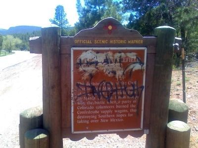
The decisive battle of the Civil War in New Mexico was fought at the
summit of Glorieta Pass on March 28, 1862. Union troops won the battle when a party of Colorado Volunteers burned the Confederate supply wagons, thus destroying Southern hopes . . . — — Map (db m119814) HM
The St. Francis Women's Club was instrumental in raising funds to rebuild San Francisco de Asís Church, which had been condemned and demolished in about 1960.
Their main fundraiser was the annual Fourth of July Ceremonial, featuring dances of . . . — — Map (db m32833) HM
Feliciana Tapia Viarrial helped establish today's
Pueblo of Pojoaque. Pojoaque, or Posuwageh, water
drinking place, is a Tewa village founded circa A.D.
900. By 1919, the Pojoaque homelands were severely
diminished. Most members left . . . — — Map (db m32835) HM
Wood peddlers, farmers and merchants went through Burro Alley. Burros economically served the many cultures of New Mexico. For many years the people of Santa Fe relied on the burro for their welfare. — — Map (db m54958) HM
1943 Santa Fe Office 1963
Los Alamos Scientific Laboratory
University of California
All the men and women who made the first atomic
bomb passed through this portal to their secret
mission at Los Alamos. Their creation in 27 . . . — — Map (db m179045) HM
1540
The first major Spanish expedition to what is now the southwest United
States was conducted by Francisco Vásquez de Coronado from 1540 to
1542. Coronado organized and financed the expedition based upon the
travels of Alvar Nuñez . . . — — Map (db m182221) HM
Seeking to expand the domain of the King of Spain in 1540, Francisco Vásquez de Coronado led an expedition of over 1,000 men and women north from Mexico into what is now Arizona, New Mexico, Texas, Oklahoma and Kansas. The Spanish explorers, in . . . — — Map (db m76166) HM
In 1573 King Felipe II of Spain decreed an end to expeditions of conquest.
However, on April 19, 1583 he directed the Viceroy of New Spain to contract
with a responsible citizen to settle New Mexico at his own expense primarily to
see to the . . . — — Map (db m182257) HM
1598
Of New Mexico's first settlers in 1598, 560 Europeans have been identified (381 men, 112 women and 67 children) in addition to several friars and a number of Mexican Indians. The women who helped to pioneer El Camino Real and establish . . . — — Map (db m182275) HM
1598
By virtue of his royal contract, don Juan de Oñate became New Mexico's first
governor. Oñate and his group of colonists left Santa Bárbara, Chihuahua in January of
1598. They crossed the Rio Grande at the present location of El Paso, . . . — — Map (db m182277) HM
The viceroy of New Spain appointed Juan de Oñate as New Mexico’s first governor and directed him to settle the area along the upper Rio Grande. Accompanied by 200 settlers and over 7,000 head of livestock, Oñate arrived in New Mexico and established . . . — — Map (db m76183) HM
1598-1890
El Camino Real (The Royal Road) sustained New Mexico's settlers from the start.
Settlers traveled north to la tierra adentro (the interior land) and back to cities in
the south. El Camino Real was a viable commercial route for . . . — — Map (db m182314) HM
1607
As early as 1607, Juan Martínez de Montoya, one of Governor Juan de Oñate's
captains founded the village of Santa Fe, writing that he had populated the site
and established a plaza. The new town was located on the Santa Fe River . . . — — Map (db m182315) HM
1610
In 1610, construction of the Palace of the Governors began as a section
of the Casas Reales de Palacio (royal houses). The Casas Reales, built
around Santa Fe's plaza included the governor's living quarters, the jail,
the town . . . — — Map (db m182316) HM
New Mexico’s third governor, Pedro de Peralta was instructed to relocate the capital to a more central location. He founded the Villa de Santa Fe, or Town of Holy Faith. The villa was named for a city of Spain built by King Ferdinand and Queen . . . — — Map (db m76198) HM
1620
The Barrio de Analco and San Miguel Church are both located on the south
side of the Santa Fe River. Analco, from the Nahuatl language of central
Mexico, means "on the other side of the water." Mexican indians who came
to New Mexico . . . — — Map (db m182318) HM
1630
In 1630 and 1635 Fray Alonso de Benavides wrote his famous Memorials
to the King and the Pope describing a beautiful fourteenth century statue
of the Virgin that he brought to Santa Fe from Mexico City in 1625. "She
is an image in . . . — — Map (db m182322) HM
In the seventeenth century New Mexico was plagued by drought, conflicts between civil and church authorities, and extreme demands placed by the Spanish settlers on the native population. The latter situation caused a deterioration so severe that by . . . — — Map (db m76202) HM
Under the direction of Don Diego de Vargas, the Spanish returned to recapture New Mexico after twelve years of exile in El Paso. In an attempt to encourage settlement of the land in the Rio Grande Valley, Don Diego de Vargas issued land grants for . . . — — Map (db m76222) HM
1712
On a stormy summer's evening in 1712, a group of citizens organized by
Juan Páez Hurtado gathered in Santa Fe to honor the memory of don Diego de Vargas. The result was a Fiesta Proclamation signed a few days later by Governor José . . . — — Map (db m182386) HM
In order to fulfill a promise that Don Diego de Vargas made, the government leaders of Santa Fe issued a proclamation calling for an annual fiesta to commemorate the peaceful reentry of the Spanish into Santa Fe in 1692. This annual celebration held . . . — — Map (db m76236) HM
When the Declaration of Independence was signed, Santa Fe was already 166 years old. English and American explorers and traders replaced the French as a source of concern to Spanish officials in New Mexico. The successful American War of . . . — — Map (db m76238) HM
1777
Don Juan Bautista de Anza, a native of Sonora, was governor of New Mexico
from 1777 to 1788. Considered one of New Mexico's best governors his
primary challenge was stopping incessant Indian raids that nearly wiped out
some of the . . . — — Map (db m182387) HM
1788
Juan Lucero, a militia officer, frontiersman and one of New Mexico's
soldados de cuero (leather clad soldiers) made 13 trips to the plains
between 1788 and 1819. He explored the Texas panhandle, the Arkansas
River valley and . . . — — Map (db m182409) HM
1827
In 1827 Antonio Armijo traveled northwest up the Rio Chama through
Colorado, Utah and Nevada before crossing the Mojave Desert into
southern California. En route he documented numerous spring-fed meadows
that would become the site of . . . — — Map (db m182394) HM
1848
The 1848 Treaty of Guadalupe Hidalgo ended two years of war between
Mexico and the United States. New Mexico, along with Arizona, California
and parts of Nevada, Utah and Colorado were now a part of the United
States. A group led by . . . — — Map (db m182410) HM
In May of 1846, U.S. President James K. Polk ordered the invasion of Mexico by U.S. troops, thus beginning the Mexican War. Three months later, General Stephen Watts Kearney led a victorious U.S. Army unopposed across northern New Mexico and into . . . — — Map (db m76263) HM
1850
For a quarter century after 1821 New Mexico was part of Mexico and
within the Diocese of Durango, Mexico. During this period secular
(diocesan) priests replaced members of the Franciscan Order. The diocesan
priests, many of whom were . . . — — Map (db m182411) HM
Shortly after the Civil War began, the Confederacy turned its attention to the Southwest, and in February, 1862, three thousand three hundred troops under the command of Confederate General Sibley, defeated the Union troops at Valverde, raised the . . . — — Map (db m76264) HM
While the nation was celebrating the Centennial, Santa Fe was into its 266th year. Although the Treaty of Guadalupe Hildago guaranteed the property of Hispanics and Indians, problems in the interpretation of Spanish and Mexican land laws worked to . . . — — Map (db m76269) HM
In 1906, Congress passed an act that would enable New Mexico and Arizona to become one large state. The residents in Arizona voted against the act, while the New Mexicans voted for it. It was not until 1912 that the opposing forces were reconciled . . . — — Map (db m76270) HM
Every year since 1926, when Will Shuster and Jacques Cartier created the image, Santa Fe and friends have been able to release their ties to depression, gloom and uncertainty by burning a symbol of these misfortunes . . . Zozobra! The burning of the . . . — — Map (db m76273) HM
During World War II, the federal government set up a secret facility in Los Alamos to coordinate the Manhattan Project, resulting in the development of the first atomic bomb. On July 16, 1945, the atomic bomb was exploded at “Trinity . . . — — Map (db m76309) HM
Santa Fe celebrated its 350th anniversary. During that year, special guests Maria Teresa Perez-Balsera and Maria Luisa Perez-Balsera arrived from Spain. The two ladies are direct descendants of Captain-General Don Diego de Vargas, the central figure . . . — — Map (db m76311) HM
Santa Fe, now 366 years old, joined the rest of the United States in celebrating the nation’s 200th birthday. New Mexico and the entire Southwest continued to see tremendous expansion and population growth with the influx of migration from the . . . — — Map (db m76316) HM
While responding to a request to give the Last Rites to a dying man, Franciscan Father Reynaldo Rivera, rector at St. Francis Cathedral, was kidnapped and brutally murdered, sending Santa Fe and the entire state into shock. Ironically, Father Rivera . . . — — Map (db m76317) HM
By proclamation of the City Council, Santa Fe celebrated its 375th anniversary. During the year, this property was donated to the city by Archbishop Robert Sanchez and the Santa Fe Fiesta Council. These gifts, together with appropriations by the . . . — — Map (db m76319) HM
The Santa Fe City Council, on April 9, 1997, passed Resolution 1997-23
establishing and providing support for a Cuarto Centenario Committee of
civic organizations and volunteers to plan and direct the commemoration of
the 1598 founding of "La . . . — — Map (db m182450) HM
Santa Fe is the oldest capital city in the United States, a successful blend of three cultures and yet a modern city of over 50,000 residents.
The Commemorative Walkway Park, constructed in 1986, provides a historical walk through Santa Fe . . . — — Map (db m76131) HM
From 500 A.D. onward, New Mexico underwent a number of comparatively rapid changes. The people throughout the western two-thirds of the state became increasingly restricted to smaller and smaller areas resulting in the development of many regional . . . — — Map (db m76136) HM
At first, traders used whatever farm wagons they could find to transport their goods, but as traffic on the trail increased, heavy freight wagons were built specifically for the Santa Fe trade. The industry employed hundreds of skilled woodworkers, . . . — — Map (db m185106) HM
Civil War Dead
An estimated 700,000 Union and Confederate soldiers died in the Civil War between April 1861 and April 1865. As the death toll rose, the U.S. government struggled with the urgent but unplanned need to bury fallen Union . . . — — Map (db m184764) HM
This neighborhood was first established in the early 1600s by Tlaxcalan Indian servants for whom the original San Miguel Chapel was built. Razed during the Pueblo revolt in 1680; resettled by families of Spanish soldiers after the De Vargas . . . — — Map (db m184948) HM
The notorious New Mexico outlaw, also known as William Bonney, was captured and sucessfully imprisoned for the last time in the downstairs jail housed in this, the Cornell Building, at 208 W. San Francisco St., Santa Fe, from December 27, 1880 to . . . — — Map (db m73714) HM
In 1697 this property was granted to Captain Diego Arias de Quiros by Spanish royal decree for his part in the reconquest of New Mexico with De Vargas. In 1879 bought by L. Bradford Prince, later Territorial Governor. In 1942 bought by Field estate . . . — — Map (db m55706) HM
Dedicated to the honor and in memory of those men and women who served their country in the interest of freedom for all mankind — — Map (db m184785) WM
In 1598 a group of Spanish colonists, led by Juan de Oñate of Zacatecas, Mexico, established a settlement along the banks of the Rio Grande north of present-day Española. In 1610 Governor Pedro de Peralta relocated the capital of the province to . . . — — Map (db m73092) HM
A Territorial period embellishment, ca. 1870, this
simulated stone facade is actually plaster with a
rectangular pattern to make it appear that the
Palace was constructed of cut stone. In fact, all
exterior and interior walls of the Palace . . . — — Map (db m179050) HM
Don Diego de Vargas Zapata Luján Ponce de León, born 1643 in Madrid, Spain, served the crown as Governor of New Mexico from 1691–1697 and 1703–1704. Vargas was a devout Christian with a strong devotion to Nuestra Señora La Conquistadora, Our Lady of . . . — — Map (db m76234) HM
Don Juan Bautista de Anza, outstanding Spanish governor of New Mexico (1776–1787), explored a new road from Santa Fe to Arispe, Sonora, in 1780. This plaque is placed in commemoration of the 200th anniversary of that historic journey.
Don . . . — — Map (db m76950) HM
Fortress and Castle
built by order of the
Spanish crown 1610-1612
Seat of Government
under three flags–Spanish,
Mexican & American-
From 1610 to 1910 the
residence of over a hundred
Governors & Captains General
The . . . — — Map (db m45588) HM
Named for then-Secretary of War William L. Marcy, Fort Marcy was the first U.S. Army fort in the American Southwest. Commanding officer Brigadier General Stephen Watts Kearny directed Lieutenant William Emory to find the most "commanding" site in . . . — — Map (db m184794) HM
Priest – Poet – Historian – Archivist
Artist – Author – Biographer – Genealogist
And native-born New Mexican
Major, U.S. Army – W.W. II & Korean Conflict
“THE LOVE I Love is one, . . . — — Map (db m72746) HM
The building you see in front of you, called the Hewett House, is one of the few remaining military buildings dating
from the period when the U.S. Army maintained two military reservations in Santa Fe (1846-1894). This adobe
building was one of . . . — — Map (db m182031) HM
Roadrunner Cowbelles dedicate this hitching post at the end of the trail to American cattlemen and their horses for their glorious role in winning the West. — — Map (db m72745) HM
This park is named after Benjamin Talbot Hyde, devoted educator of America’s youth. His family donated the 350 acres which constitutes the park to the State of New Mexico in 1934. Situated at an elevation of 8,500 feet in the scenic Sangre de Cristo . . . — — Map (db m73259) HM
In honor of those who gave the Ultimate Sacrifice in service to the United States of America and the families they left behind. The sacrifice will not be forgotten. — — Map (db m184769) WM
Front:
Inez Bushner Gill impressed governors, legislators and journalists with her fiscal expertise. Among the original staff of the Legislative Council Service when it was founded in 1951, she served as fiscal analyst and principal staff for . . . — — Map (db m119928) HM
U.S. President James K. Polk assigned the invasion of New Mexico and California to General Stephen Watts Kearny, who marched the Army of the West into Santa Fe on August 18, 1846. Governor and Commanding General Manuel Armijo had publicly demanded . . . — — Map (db m184792) HM
Chief Justice, Territory of New Mexico, 1879-1882
Territorial Governor of New Mexico, 1889-1893
L. Bradford Prince's contributions to New Mexico and its people spanned more than forty years of service. He is described by historians as every . . . — — Map (db m185109) HM
On this site stood the memorable Chapel of The Lady of Light, often called the “Castrense” which marked the northernmost limit of Mexican Baroque style. Here in Santa Fe flourished the Hispano-American civilization which this Chapel typified. . . . — — Map (db m64841) HM
Built in 1878, the Lamy Building was originally part of St. Michael's College. The lower two floors, which remain today, were constructed of adobe. The third floor, with its mansard roof and domed cupola, was framed in wood, probably to reduce the . . . — — Map (db m45594) HM
Come and Get It!
The ingredients were meager and the menu was basic: biscuits, bacon, and coffee for travelers on the trail in the 19th century.
But with those simple ingredients, supplemented by fresh meat killed on the trail and . . . — — Map (db m185098) HM
(side one)
Four Sisters of Loretto, Mother Magdalen Hayden and Sisters Roberta Brown, Rosana Dant and Catherine Mahoney, arrived in Santa Fe from Kentucky on September 26, 1852. In January 1853 they established Our Lady of Light Academy, . . . — — Map (db m119764) HM
This property has been placed on the National Register of Historic Places by the United States Department of the Interior The Historic Santa Fe Foundation finds this building worthy of preservation Museum of Fine Arts — — Map (db m182034) HM
Richard P. "Dickie" Montoya served in the city of Santa Fe Police Department for 17 years, and later was appointed Chairman of the New Mexico State Public Service Commission. After his retirement, he went on to become a real estate developer and . . . — — Map (db m185108) HM
Oldest church structure in U.S.A. The adobe walls and altar were built by Tlaxcalan Indians from Mexico under the direction of Franciscan Padres. ca. 1610 — — Map (db m116019) HM
Santa Fe Cathedral Park and Monument A gift to the citizenry of Santa Fe and the State of New Mexico commemorating the first European settlers of New Mexico - the Spanish colonists of 1598.
The year 1998 marked the 400th anniversary of the . . . — — Map (db m181926) HM
Santa Fe Plaza
has been designated a
National Historic
Landmark
The heart of Santa Fe since its founding by Spanish colonial Governor Don Pedro De Peralta in 1609-1610, this public space was a terminus of El Camino Real and the . . . — — Map (db m71579) HM
When Don Juan Sena bought this land in 1796, Santa Fe belonged to Spain. When Major José D. Sena built this house for his bride Doña Isabel Cabeza de Baca in 1831, Santa Fe belonged to Mexico. In 1846 Santa Fe became part of the United States. — — Map (db m55709) HM
Also used as two-story defensive tower for Palace of the Governors during the 1600’s. Gen. Don Diego de Vargas was probably buried beneath the floor of this chapel in 1704. — — Map (db m64842) HM
The President of the United States of America, authorized by Act of Congress, March 3, 1863, has awarded in the name of Congress the Medal of Honor to
Staff Sergeant Leroy A. Petry
United States Army
Staff Sergeant Leroy A. Petry . . . — — Map (db m182041) HM WM
The large mounds you see on the rise in front of you are the eroded remains of the walls of Fort Marcy's blockhouse. It was built in 1846-1847 on the highest place on Fort Marcy hill for use as a guardhouse and soldiers' quarters. Unlike the fort, . . . — — Map (db m184795) HM
This courtyard is dedicated to Catua and Omtua, two messengers from the Pueblo of Tesuque (Taytsugeh Oweengeh) who were captured and executed by Spanish authorities. Their execution led, in part, to the start of the Great Pueblo Revolt which began . . . — — Map (db m182055) HM
(right tablet) On March 30, 1609, the Viceroy of New Spain appointed Don Pedro de Peralta Governor and Captain-General of New Mexico, instructing him to proceed to New Mexico with the greatest dispatch accompanied by twelve soldiers and . . . — — Map (db m76340) HM
Labyrinths have been used around the world since at least 2000 B.C. Their patterns were
built into the floors of medieval Cathedrals and walked by pilgrims of that time. This
labyrinth is built in the style of the one at the great cathedral in . . . — — Map (db m181860) HM
The Old Spanish Trail from Santa Fe to Los Angeles. In the years 1829 to 1848 pack mule trains regularly left the Santa Fe Plaza and northern New Mexico carrying woolen goods produced in New Mexico bound for California. Horses and mules were . . . — — Map (db m64852) HM
Near to where you are standing is the route of one of the great overland trails of one of the great overland trails of the old west. Established in 1821, as a trade route between Franklin, Missouri, in the United States, and Santa Fe, then part of . . . — — Map (db m185096) HM
The Spitz Jewelry Store was established on the Plaza in 1881, and a clock, without works, was placed in front of the store to advertise the wares offered. Near the turn of the century, this “clock” was replaced by a functioning sidewalk . . . — — Map (db m64966) HM
(South face):
To the Heroes
of the Federal Army, who fell
at the Battle of Valverde.
Fought with the Rebels
February 21, 1862
(West face):
To the Heroes
of the Federal Army, who fell
at the Battles of . . . — — Map (db m45586) WM
The officers and crew of the light cruiser, U.S.S. Santa Fe, dedicate this plaque to the memory of the gallant men who fought and served aboard her from 1942 to 1946. — — Map (db m54960) WM
This is placed in honor of all the Vietnam veterans on the 50th anniversary of the war to pay tribute to the valor of those who served proudly and courageously. Our heartfelt thanks and gratitude for your service and sacrifice on behalf of the . . . — — Map (db m184777) WM
Fort Marcy was constructed in 1846 at the outset of the Mexican-American War by the U.S. Army following the invasion and capture of the Mexican city of Santa Fe. The Americans built a fort atop this hill to protect the troops in the case of an . . . — — Map (db m183673) HM
Santa Fe's oldest and best known restaurant.
Established in 1944 by Rosalea Murphy. The Pink Adobe is regarded as Santa Fe's own national treasure. The "Pink" is located in the historic Barrio de Analco, one of the oldest areas of Santa Fe and . . . — — Map (db m184949) HM
You are standing on Fort Marcy Hill, a site of human occupation for a thousand years. Pueblo Indians and their ancestors lived here. Between 1600 and 1680, the hill was common land for Santa Fe colonists. The Spanish built a small fort on a hill . . . — — Map (db m184791) HM