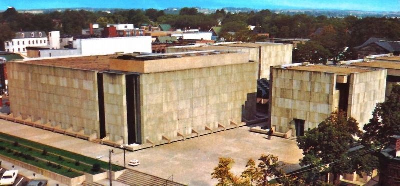
English: The Confederation Centre of the Arts was officially opened by Queen Elizabeth II on October 6, 1964 as a living memorial to the Fathers of Confederation. Located beside Province House in Queen Square, it was designed by the . . . — — Map (db m149912) HM
English: "From the beginning, the river drew people to settle its banks and use its waters to reach the settlements..." The Hillsborough River, Elsitkuk as the Mi'kmaq would say, is the Island's largest river. It runs east . . . — — Map (db m149601) HM
English: Across Charlottetown Harbour on the west side was the home base for the Acadians in the early years of the 1700's. It was called Port-la-Joye and Fort Amherst by the English. The Mi'kmaq called it Skma qan which . . . — — Map (db m149600) HM
English: Even though it was the capital of Canada's smallest province, it took almost 100 years before Charlottetown became of strong historical importance. On August 31, 1864 the delegates began arriving for what is now referred to . . . — — Map (db m149905) HM
English: Charlottetown is the home of two important educational institutions. The University of Prince Edward Island was established in April 1969. It resulted from a merger of two institutions: Prince of Wales College that began as . . . — — Map (db m149899) HM
English: Charlottetown has been working on its beautification for well over 150 years. On Arbor Day May 24, 1884 more than 300 trees were planted in the squares and along the streets. The tradition continues. Our trees are . . . — — Map (db m149902) HM
English: The Colonial Building, now known as Province House, is in the middle of Queen Square. It was the prime location for the meetings of the Fathers of Confederation in 1864. The building was officially opened on January 26, . . . — — Map (db m149910) HM
English: Victoria Park, at the west end of the city, was vested by the Crown to the City of Charlottetown in 1873. The 40 acres of land presents a gentle place protected by a special Act that declares the park "for the sole purpose . . . — — Map (db m149901) HM
English: Architecturally speaking, Charlottetown is predominately a wooden town with buildings dating back to the early 1800's. When you see a brick building you can be pretty sure it was built after the Great Fire of 1866 that . . . — — Map (db m149909) HM
English: In 2015, the celebration marking, Charlottetown's 250 years on its chosen site provides an excellent opportunity for Charlottetown to ponder its past and its future. As a home to many new Canadians, the responsibility to . . . — — Map (db m149903) HM
English: The Provincial Government has its administrative headquarters in the west end of the city, their Court House on the waterfront and the offices for official political parties are housed in the Coles Building on Queen Square. . . . — — Map (db m149911) HM
English: Government House, at the west end of the city was built in 1834. It is a gracious house and still serves as the official residence of the Island's Lieutenant Governor. Their Honours host many events to which the public is . . . — — Map (db m149913) HM
English: The City of Charlottetown was incorporated in April 1855. The present boundaries of the city are a result of an amalgamation of six surrounding communities in 1995. The City is governed by a mayor and 10 councilors. Its . . . — — Map (db m149908) HM
English: The Port of Charlottetown has a history of wooden shipbuilding, local ferry wharves and shipping connections with the world. Family connections with the Westcountry of England made it a prime destination. Shipbuilders, . . . — — Map (db m149906) HM
English: In 1768 Charles Morris, a Halifax Surveyor, was directed to lay out the town under the directions of the Board of Trade and Plantations in London. Later the Island's first British Governor, Walter Patterson, through his . . . — — Map (db m149900) HM
English: The railway played a major role in shaping Canada and it played an important role in the development of Prince Edward Island. The sod was turned for the PEI Railway on October 5, 1871 just north east of where you are . . . — — Map (db m149897) HM
English: The site of Charlottetown was chosen by Surveyor General Samuel Holland on his survey of St. John's Island. Now called Prince Edward Island, it was once called Epekwitk, which means "lying on the water", by the . . . — — Map (db m149904) HM
English: The Railway Station stands not far from where you now stand. The air was once full of steam, the sound of train whistles and shunting rail cars. It was a busy place with the Western train, the Eastern train and the Murray . . . — — Map (db m149898) HM