807 entries match your criteria. Entries 101 through 200 are listed.⊲ Previous 100 — Next 100 ⊳
Native Sons/Daughters of the Golden West Historical Markers
The NSGW was formed by Albert Maver Winn in 1875 to preserve the California historic buildings and sites of the Gold Rush and prior. The only requirement to be a member is to have been born in California. The sister organization, NDGW, followed soon thereafter.
"Site of 1st Sawmill
Erected by Argonaut Parlor No. 8 Native Sons and Gold of Ophir Parlor No. 190 Native Daughters, commemorating the Bicentennial Year 1776 – 1976” — — Map (db m61558) HM
“Site of first flour mill in Ophir City now Oroville, built in 1858. Erected and dedicated by Argonaut Parlor No. 8 Native Sons and Gold of Ophir Parlor No. 190 Native Daughters as part of the Bicentennial Year Celebration 1776 – . . . — — Map (db m65842) HM
For thousands of years the Yahi Indians roamed the foothills between Mt. Lassen and the Sacramento Valley. Settlement of this region by the white man brought death to the Yahi by gun, by disease, and by hunger. By the turn of the century only a few . . . — — Map (db m100601) HM
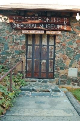
To commemorate The Mother Orange Tree of Butte County planted at this spot by Judge Joseph Lewis in 1856.
The Bidwell Bar Bridge, first suspension bridge of California, transported from New York via Cape Horn 1853. Completed 1856. . . . — — Map (db m100596) HM
On these 4 corners was the Old Town of Paradise, known in the 1860’s as Leonard’s Mill. Just north was the mill, hotel and stage stop. To the N.E. was a turpentine distillery. To the east was the school. The Paradise post office was established and . . . — — Map (db m66140) HM
Constructed in 1903, this depot is one of three maintained along the Butte County Railroad, a 31 mile line from Chico to Stirling City, completed by Diamond Match Co. in 1904. The railroad was later acquired by Southern Pacific and operated as a . . . — — Map (db m29671) HM
Erected by
Argonaut Parlor No. 8
Native Sons of the Golden West
and
Butte County Board of Supervisors
to designate the site of the first
county seat of Butte County.
Hamilton
1851 – 1853
Site of Court House was 600 yds. . . . — — Map (db m95740) HM
Built in 1899 by the Methodist Episcopal Church, it sits on the Beckwourth Trail. It was donated to the Wyandotte Community Association and named after the pioneer of the Wyandotte area, William Dunstone. In 2016, it became the home of Argonaut . . . — — Map (db m159622) HM
Is the site of the longest running continuously operated foundry west of the Mississippi River. All quartz machinery needed for the numerous mines surrounding the Altaville, Angels Camp area was cast here. It was previously known as Altaville . . . — — Map (db m13005) HM
This brick building, erected in 1858 with funds raised by a dance in the Billiard Saloon of the N.R. Prince Building (which still stands), is one of the oldest schools of California. Used as a school until 1950, it was then replaced by the present . . . — — Map (db m10143) HM
This structure was erected in 1852 by B. R. Prince and G. Garibardi for a general merchandise business. Improved in 1857 with living quarters on the second floor, it is still used for living and warehouse purposes. — — Map (db m11047) HM
The use of wheels to convert flowing or falling water into power began in ancient Greece around the third to the first century B.C. In 1878 Lester Allan Pelton, a carpenter and blacksmith from Nevada City, invented a new design for an impulse water . . . — — Map (db m101590) HM
In 1895 Harry Hogarth, James Candy and Naylor Williams filed a claim for the Relief Quartz Mine on a hillside above Six Mile Creek near Angels Camp. In 1920, after working the claim by hand for many years, the Hogarths; Harry Sr, Harry Jr, and . . . — — Map (db m56553) HM
This steam traction engine was built by Owens, Lane, Dyer & Co. of Hamilton Ohio most likely in the 1870s. Its particular gear drive mechanism, along with the incline cylinder distinguish it as an O.L.D. & Co. machine. According to the story, this . . . — — Map (db m101594) HM
This Best 110 hp steam traction engine, built 1903-1906, was originally used by Pacific Borax Co. to pull ore wagons. The next owner was the Dixie Mill, near Sheep Ranch, where it was used to haul logs down the steep hillsides to the loading deck. . . . — — Map (db m101613) HM
This core section was created in 1934 while boring an air/service shaft for the Idaho-Maryland Mine in Grass Valley, California. The overseer of this demanding project was mining engineer J.B. Newsome. Reputed to be the largest drill core of its . . . — — Map (db m101617) HM
This natural formation came from a cavern on the property of the Calaveras Cement Co., located near Calaveritas in Calaveras County. It was donated to the museum by the Flintkote Co. in 1957. Collectively known as speleothems, these ancient . . . — — Map (db m101618) HM
The Utica Mansion was built in 1882 as a two-story, stone, Federal style home by mine owner, Robert Leeper. In 1884 the mine was purchased by Charles D. Lane, under whose ownership the newly formed Utica Mining Company was developed on a major . . . — — Map (db m219111) HM
Utica Mine, the most important mine in the Angels District, set national records in the 1890's producing more than 4 million dollars in gold in 30 months. The Utica was also the site of Angels Camp's worst mine disaster when 17 men were buried when . . . — — Map (db m25646) HM
Hotel and stagecoach relay station, halfway between Murphys and Big Trees. Settled in the 1850’s by Joseph and Sarah Goodell. Purchased by Peter Avery, then operated by three generations of Averys - Peter and Nancy, George and Henrietta and Morton . . . — — Map (db m10615) HM
He conducted a butcher shop, a distillery and various other enterprises in these buildings, for a total of 50 years. Descendants of Luigi and Charlotte Costa have preserved this handsome example of the heritage of Calaveritas. — — Map (db m12994) HM
Copperopolis Armory, built by public subscription in 1866 for 8,000 dollars, was used by the Union Guard for enlisting and training troops. In 1866 it was sold to the Copperopolis Armory Hall Association for 800 dollars in gold and was used for . . . — — Map (db m13003) HM
Mokelumne is an Indian word, first applied to the nearby river. Earliest settlement was at Happy Valley by French trappers. Gold was discovered by discharged members of Stevenson's Regiment in 1848. Center of the richest placer mining section of . . . — — Map (db m12996) HM
This original stone building was built in 1889 by Peter Malaspina. The family run business housed a general store and, in 1917 a standard oil station was added. First run by John Henry and Mary Malaspina-Batten and later, daughter Ina Batten-Davies, . . . — — Map (db m218942) HM
Buena Vista Cemetery's oldest grave marker, for a six year old boy, has the date of death of June 26, 1855. Older graves may exist that have no markers on them. Buena Vista is the earliest official burial location in Murphys. In 1930, Buena Vista . . . — — Map (db m66122) HM
Built 1901, on land donated by Joseph Heinsdorff, Sr., for use by the Independent Order of Odd Fellows. The two-storied shiplap-sided structure was constructed with locally milled lumber, using large stones as foundation. In 1991, the stones were . . . — — Map (db m32860) HM
After a fire in 1859, pioneer Doctor Jones rebuilt this structure to withstand future disasters. It served as his office, and is constructed of limestone, brick, 30 inch windowless walls and iron shuttered doors. In 1867, it was sold to John Hauselt . . . — — Map (db m16049) HM
One of the principal mining communities in Calaveras County, named for the discoverer of gold on the flat in 1849. The objective of many immigrants coming over the Sierras by Ebbetts Pass, Murphys Flat and surrounding mines produced 20,000,000 . . . — — Map (db m149203) HM
This home was built by Charles A. and Catherine Caswell Curtis in July 1853. The home comprised four rooms and side porches. The original canvas ceiling was later covered with pine. The original pine plank flooring and cellar both still exist today. . . . — — Map (db m218940) HM
Chispa Parlor No. 139 was chartered April 10, 1889, dissolved April 25, 1896, and reorganized March 14, 1905.
This site was first occupied circa 1860 by the Independent Order of Good Templars, a group dedicated to the prohibition of liquor and . . . — — Map (db m33008) HM
Rebuilt in 1859 as a stone, fire-proof, grocery and provisions store by Vassallo & Co. In 1861 was the homestead of J.C. Green & Wife. By 1863 owned & operated as a bakery by B.M. Orengo & Ruiseco. It is said that the baker Ruiseco was shot to death . . . — — Map (db m51568) HM
This hostelry originally built in 1855 by J. L. Sperry of Sperry Flour fame and his partner John Perry. Among early guests whose names appear on old register are Mark Twain, Horatio Alger, Thomas H. Lipton, Henry Ward Beecher, the Rothchilds General . . . — — Map (db m143521) HM
Constructed by Peter L. Traver in 1856, this is the oldest stone building in Murphys. Its iron shutters and sand on the roof protected it from the fires of 1859, 1874, and 1893. It served as a general store, a Wells Fargo office, and later a garage. — — Map (db m2611) HM
A thriving mining camp on rich Pennsylvania Gulch in the 1850’s and 1860’s. Named for Alfred Brown, former owner of Table Mountain Ranch. Laws of Brownsville Mining District provided that each miner could own one wet and one dry claim, not to exceed . . . — — Map (db m11501) HM
The stone portion built circa 1879 by Bernardo Bisso, called Stangetti, who ran a store until its sale to Sebastian Solari , circa 1881-83, who added the wooden portion and also operated a store. The stone section has walls more than 20 inches thick . . . — — Map (db m16189) HM
In 1862, tinsmith Louis Robinson constructed this brick and stone building to replace his original frame store which was destroyed in the fire of August 20, 1859. In 1869 it became a bakery and store, a use it was to have over the next 40 years. The . . . — — Map (db m16016) HM
One of the pioneer structures in Murphys, built after the great fire of 1859 by Freeman Dunbar and Company and called Union Saloon and Bowling Alley. It was operated in the 1870’s by W.C. Crispin, and in the 1880’s by Charles E. Fisk. Later it was a . . . — — Map (db m32814) HM
One of California's important early day mining towns named by Mexicans meaning Little Valley. Gold was discovered here by the Murphy Brothers on 1849. It was originally called "Murphys' Old Diggings". This bell was cast at Troy N.Y. in 1853. . . . — — Map (db m6841) HM
This site, in 1849, was a trading center for pioneer miners of Northwestern Calaveras County. It was named after the gulch where William and Dan Carsner found large nuggets imbedded in the course sand.
Water for mining was brought from the Middle . . . — — Map (db m11975) HM
This Plaque commemorates the arrival
of the first settlers in Antioch.
September 16, 1850
Led by Captain George W. Kimball
the party sailed from Maine aboard the
California Packet No.2 March 1850
And reached San Francisco Bay
August . . . — — Map (db m37593) HM
Builders of the stone house 1856
Abby Marsh died August 1855
John Marsh first doctor in California arrived 1836
Born 1799, Murdered Sept. 24 1856 — — Map (db m94654) HM
Four hundred feet west of this plaque Victor Ramon Castro
1817 - 1900 built three adobe dwellings, the south one in
late 1830's the main one or west one in 1840's the
north in late 1840's They with later additions were
destroyed by fire April . . . — — Map (db m144264) HM
First sheriff of Contra Costa County 1850-1852 which then also included portion of Alameda County
This tablet donated by Sheriff John A Miller of Contra Costa County and Sheriff M.B. Driver of Alameda County and placed by Native Sons of the . . . — — Map (db m216832) HM
This pioneer cemetery was the Protestant burial ground for those who died during the 19th century boom of the Mt. Diablo Coal Mining District. It is located midway between Nortonville and Somersville townsites.
Many of those buried here died in . . . — — Map (db m197754) HM
Plaque One:
Dedicated to those from Contra Costa County who served their country in the World War, and to the memory of these who “Gave the last full measure of devotion”
1914 – 1918
Simeon M. Anderson • Adolph C. Bauer, Jr. • Peter . . . — — Map (db m217766) WM
This warehouse was built in 1886 by G.W. McNear, as the first fireproof building in Contra Costa County. It was built for the storage of wheat, hay and potatoes. From 1881 to 1882 one-hundred and three ships of wheat were loaded in Port Costa. It . . . — — Map (db m94253) HM
Constructed in 1873-74, East Brothers Light Station is the older of only two remaining light stations of San Francisco Bay that have remained substantially unchanged. The original 5th order classical (Fresnel) lens was replaced with the present . . . — — Map (db m164491) HM
Presented
by the
N.S.G.W. No. 217
and
N.D.G.W. No. 147
of Richmond
In memory of those who served the United States in time of war — — Map (db m144414) WM
Founded by Scottish gold miner James Skinner in 1861 in the community that became known as Skinners. Strategically placed on the Pony Express Trail, the J. Skinner Native Wine and Brandy Co. was one of the first commercial vineyards in the country, . . . — — Map (db m66603) HM
On the occasion of James W. Marshall's 200th birthday, the Native Sons of the Golden West rededicate this monument erected in his honor. Born in Hopewell Township, Mercer County, New Jersey to Phillip and Sarah Wilson Marshall on October 8, 1810, he . . . — — Map (db m71528) HM
Erected by the State of California in memory of James W. Marshall, 1810 - 1885, whose discovery of gold January 24, 1848 in the tailrace of Sutter’s Mill at Coloma started the great rush of Argonauts. — — Map (db m146477) HM
James Marshall arrived in the “Collumah”, valley home of the Nisenan, on May 8, 1847 to map the site for a sawmill he was to build in partnership with John Sutter. On August 18, Marshall returned with a crew, mostly Mormons, to build the mill. On . . . — — Map (db m39013) HM
Originated at time of gold discovery also known as “Coloma Protestant” or “Vineyard House” Cemetery. Still used by local pioneer families. — — Map (db m12277) HM
This rock monument marks site of John A. Sutter's saw mill in the tailrace of which James W. Marshall discovered gold, January 24, 1848, starting the great rush of argonauts to California. The Society of California Pioneers definitely located and . . . — — Map (db m39015) HM
Here in the Valley of the Cul-lum-mah Indians, James W. Marshall discovered gold on January 24, 1848, in the tailrace of Sutter’s sawmill. The Old Coloma Road, opened in 1847 from Sutter’s Fort to Coloma, was used by Marshall to carry the news of . . . — — Map (db m12272) HM
The oldest fraternal edifice in continuous use on the West Coast. Built on this hillside, not on the main street as in the usual practice for the era. It avoided the ravages of fire which razed the town of Diamond Springs on several occasions. . . . — — Map (db m19263) HM
Erected in 1852 by
Diamond Springs Lodge No.9
I.O.O.F.
Oldest building in constant use
By the Odd Fellows in California
Dedicated to the memory of the
Pioneer Odd Fellows
Of El Dorado County by
Marguerite Parlor No.12
Native . . . — — Map (db m19264) HM
Hiram Lodge No.43: Free and Accepted Masons, was chartered in the town of Mud Springs, as it was then called, May 16, 1854. The Lodge met in rented buildings until the completion of this brick edifice in 1862.
On September 17, 1923 a fire . . . — — Map (db m12396) HM
These historic mining towns, and other mining camps of the Gold Rush Era, now inundated by Folsom Lake, are commemorated by the Mormon Island Memorial Cemetery nearby. Here were reburied the pioneers whose graves were flooded when the lake was . . . — — Map (db m210974) HM
At this site on the old Clarksville-White Rock Emigrant Road was Mormon Tavern. Constructed in 1849, this popular stage stop was enlarged and operated by Franklin Winchell in 1851. It became a remount station of the Central Overland Pony Express and . . . — — Map (db m12056) HM
[Three small markers are mounted on the front of the building:]
Marker 1:
Balsar House
A hotel built in 1850 by
Madam Balsar
Remodeled for an opera house in 1870. Restored by the Independent Order Odd Fellows and used as a . . . — — Map (db m54812) HM
During the 1850’s the Methodists were the first to serve in the mining towns of El Dorado County. Some ministers traveled on horseback from one mining town to another with a Bible and a Colt Revolver. Known as Georgetown Methodist Episcopal Church, . . . — — Map (db m55075) HM
Education for children on the Georgetown Divide began with home schools for a few gold miner families in the early 1850s. The first permanent school was established in 1854, on School Street. It was replaced in 1890 by a two-story school house on . . . — — Map (db m93981) HM
One and a half miles north of Georgetown sailors from Georgia established claims in 1849. General store and mining camp in 1850 which later produced by seam diggins hydraulic and flood sluicing methods. The famous Blue Rock, Pacific Beattie and . . . — — Map (db m54943) HM
Built circa 1850, originally two separate buildings, it housed many businesses during the Gold Rush era including hardware and furniture stores. It survived five, 19th century fires, including an 1897 conflagration that destroyed all but the brick . . . — — Map (db m219772) HM
Historically speaking, to cross the Rubicon River meant that you had passed the point of no return. This trail was originally used by Native Americans as a trade route. In the 1800s it became the main byway from Georgetown to Lake Tahoe. The route . . . — — Map (db m105984) HM
The first school house in Greenwood was located yards from this location. It burned down in 1855. In 1858 the Greenwood School District was established and this one room school house was built by the community. It remained open from 1859 to 1954. . . . — — Map (db m105978) HM
Original Marker - Missing
First Replacement Marker - See Photo #2
Pilot Hill Grange No.1, of 29 charter members: Master, F. D. Brown; Secretary, A. J. Bayley; was organized August 10, 1870. The Grange Hall, dedicated at this site . . . — — Map (db m11607) HM
One of the oldest preserved homes of Placerville (Old Hangtown) originally built in 1853 by Col. Fred A. Bee, pioneer merchant, and enlarged in 1889 by Judge Marcus P. Bennett, early jurist, retaining redwood ornate paneling woodwork and fireplace . . . — — Map (db m42260) HM
This fieldstone building was built by Giovanni N. Lombardo in 1872 from stones cleared to plant vineyards on the property. The lower cellar was used to produce wine for the local community. The grapes were crushed in the upper story living room and . . . — — Map (db m101534) HM
This building was erected in the Fall of 1860 for Confidence Engine Company No.1, organized in June 1857. City government located here since 1902. — — Map (db m35546) HM
This city in the days of ’49
was called
“Hangtown”
This was the site of Elstner’s Hay Yard on which stood the ‘Hangman’s Tree’ where vigilantes executed many men for various crimes. The stump of the tree is under this . . . — — Map (db m10504) HM
Whose deep concern for the conservation and improvement of our forests led him to establish the Eddy Tree Breeding Station on this site in 1925. His own effort and funds created this oldest forest genetics research institution in the Western . . . — — Map (db m105854) HM
Morning Star Lodge #20 was instituted February 9, 1854. The Lodge met for several years on the second floor of a 48 x 24 foot hillside building near here. In 1859, the members erected a building on this site. On May 15th, 1910, a fire started in the . . . — — Map (db m35518) HM
In 1852 Phillip L. Platt preempted a ½ quarter section here. He erected a log building for the lodging of miners. He named his hotel The Kossuth House. Dr. Platt died in 1853. His widow sold the property to Anna W. Clark for $200 in 1856. She . . . — — Map (db m13165) HM
First operated by Elias Parker, only Gold Rush hotel still standing in Placerville. Used as the Placerville Academy School from 1871 – 1894. Dedicated May 6, 1962, by Marguerite Parlor No.12, Native Daughters of the Golden West on their 75th . . . — — Map (db m12760) HM
Scene of the robbery of two coaches of the Pioneer Stage Line running between Virginia City, Nevada, and Sacramento, California, on the night of June 30, 1864, at about ten o’clock. Perpetrated by a gang of fourteen men, eight sacks of bullion and . . . — — Map (db m13922) HM
Past this point on the Old Coloma Road, running between Sutter’s Fort and his sawmill on the American River, James W. Marshall rode with the first gold discovered at Coloma on Jan. 24, 1848. Traveled by thousands to and from the diggings, this road . . . — — Map (db m11268) HM
This was the site of a popular roadhouse, where the ponies of the Central Overland Pony Express were changed during July 1, 1860 to June 30, 1861. From here the route of the pony riders continued westward to Folsom and eastward through Rescue, Dry . . . — — Map (db m10442) HM
The Josephine Mine was an integral part of the 1849 California Gold Rush and remained in operation until 1937. This cemetery is the final resting place of some of the pioneers that forged the western frontier and veterans of early American wars. The . . . — — Map (db m67644) HM
This is the approximate site of Coaling Station A established by the S.P.R.R. in the late 1880’s from which the City of Coalinga derived its name. — — Map (db m229469) HM
Fresno means ash tree in Spanish. For many years, this section of California was known as the "Fresno Country” because of the ash trees that grew along its waterways. One of its rivers was named Fresno. Fresno City was established on the west side . . . — — Map (db m229390) HM
At the corner of Mariposa and I streets, from
October 1910 to March 1911, the Industrial
Workers of the World fought for the right
of free speech in their efforts to organize
Fresno's unskilled labor force. This was the
first free speech . . . — — Map (db m241573) HM
Originally built in 1857 by Augustus Jacoby, this building was constructed of locally quarried stone and brick. This was the first fire proof building in Humboldt County. Jacoby left Arcata in 1862 and mercantile firms continued to occupy the . . . — — Map (db m94513) HM
Dedicated to the
Gregg-Wood Party
and
Members of the Union Company
Founders of the
Town of Union
Now known as the City of Arcata
April 30, 1850
Members of the Gregg-Wood Party
Dr Josiah Gregg · Thomas Sebring ·
David A. . . . — — Map (db m143253) HM
Richard Sweasey originally financed the construction of this theater which displays his name. Mr. Sweasey was a businessman in the early days of Eureka. Sweasey served as a member of the California State Legislature and several terms as a Humboldt . . . — — Map (db m71971) HM
Dedicated to the memory of my parents
Joseph H. & Annie F. Clarke
and other pioneers of Northwestern California
by Cecile Clarke
Dedicated August 21, 1960 by the Native Sons of the Golden West — — Map (db m1505) HM
Built in 1884, this building became home of “Columbia Hose Company Number 4”, chartered April 2, 1894. It is the oldest surviving structure of the 7 volunteer companies organized in Eureka between 1873 and 1908. Original building had 2 . . . — — Map (db m91922) HM
This historic building was erected in 1887 by L.T. Kinsey and sold to the Society of Humboldt County Pioneers in 1890. On June 15, 1897 it was purchased by Humboldt Parlor No. 14 N.S.G.W. — — Map (db m71970) HM
EFD Chief: Oscar Paul
Sequoia Company No. 6 Foreman Walter S. Selvage
Mustered into service by Ordinance #357 on July 12, 1904
On July 3, 1904 the property at 1766 J Street was purchased from C. G. Taylor for $550. Construction began on the new . . . — — Map (db m159665) HM
Sequoia Park Zoo has been an integral part of Eureka's community since 1907. Founded on land acquired from the Glatt family to be used as a city park, the zoo has provided a home for many cherished animals and fond family memories. For more than a . . . — — Map (db m219657) HM
807 entries matched your criteria. Entries 101 through 200 are listed above. ⊲ Previous 100 — Next 100 ⊳