On French Town Road, 1 mile east of Wisconsin Highway 69, on the right when traveling east.
Final resting place of early French emigrants and their descendants. Coming directly to the Montrose-Belleville community from St. Germain in eastern France, 32 families arrived beginning in the early 1850's. Unique and isolated, the group . . . — — Map (db m37296) HM
On Mills Street (State Highway 78) at Spring Street, on the right when traveling south on Mills Street.
Town of Vermont farmers, beset by a depressed economy in the early 1890's, organized a company to obtain quality products at fair prices. Amos Thorsrud was the first general manager. He and Nels Simley toured local farms to sell $10 shares in a . . . — — Map (db m41930) HM
On County Route ID at Division Street (County Route F), on the left when traveling east on County Route ID.
The onset of the Black Hawk War in northwestern Illinois in April, 1832 triggered panic in southwestern Wisconsin's lead mining region, prompting erection of over a dozen stockades. On an open prairie knoll 3/4 mile south of this marker, area miners . . . — — Map (db m35412) HM
On South Erbe Road, 2 miles south of U.S. 18-151, on the left when traveling south.
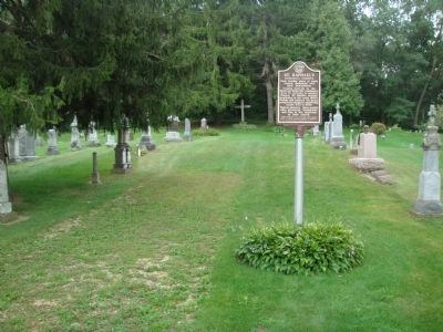
German immigrant families from Hesse began settling in this area of Blue Mounds Township in the 1840s. As early as 1856, Lutheran missionaries conducted home services for the rural community. In 1867, on acreage purchased from Justus Heuser, a frame . . . — — Map (db m75828) HM
On East Church Road, 0.4 miles west of Hillside Road, on the right when traveling west.
Koshkonong Prairie with its twin churches at both East and West Koshkonong is one of the focal points from which Norwegian Lutheranism spread to many parts of the American continent.
In 1844 at the request of pioneer Norwegian immigrants . . . — — Map (db m36145) HM
On West Cottage Grove Road (County Highway Bb) 0.5 miles west of Main Street (County Highway N), on the left when traveling west.
The Cottage Grove Grange, which became a leader in the state and national Grange movement, had its meeting hall near this site shortly after the Civil War. As a community center it became a significant cultural and social influence for pioneer farm . . . — — Map (db m37290) HM
On County Road P, 0.3 miles south of U.S. 14, on the left when traveling south.
In 1838 at the foot of this bluff Berry Haney, a migrant from Cross Plains, Tennessee, established the Cross Plains Post Office in a log house. Early Cross Plains was the site of important military road crossings and Haney became the pioneer . . . — — Map (db m32617) HM
On County Route Z, 0.5 miles west of Wisconsin Highway 78, on the left when traveling north.
Early Norse pioneers who realized a need for a house of worship built the first Norwegian Lutheran Church in western Dane County from logs in the winter of 1851-52. First services held May 27, 1852 by the Rev. A.C. Preus. Previous itinerant pastors . . . — — Map (db m36718) HM
On East Main Street (State Highway 113) 0.1 miles west of 2nd Street, on the right when traveling west.
Dane County was created by the Wisconsin Territorial Legislature in 1836. Judge James Doty had convinced the Legislature to select Madison as the Capital and name the surrounding county in honor of Nathan Dane, a compiler of the Ordinance of 1787, . . . — — Map (db m37643) HM
On Dunroven Road at County Road DM, on the right when traveling south on Dunroven Road.
In July, 1833, Lt. Alexander Center blazed a nearby oak, marking the 100-mile point of a military road he and James Doty were surveying. The Old Military Road, built from 1835 to 1837, connected Ft. Crawford at Prairie du Chien, Ft. Winnebago at . . . — — Map (db m36907) HM
On South Main Street (County Highway CV) near Holum Street, on the right when traveling south.
Andreas Dahl came to DeForest from Valdres, Norway in 1869. For more than a decade as an itinerant photographer in southern Wisconsin, he took pictures that captured the essence of life at that time. His studio stood to the north of this site and . . . — — Map (db m37005) HM
On Wendt Road, 0.5 miles County Route M, on the left when traveling north.
Illinois Central Depot side
On this site a two-story railroad depot stood from 1888 to 1939. The depot served the Illinois Central Railroad, which provided passenger and freight service to Fitchburg on its route from Freeport, Illinois to . . . — — Map (db m120014) HM
On North Park Street at West Washington Avenue, on the right when traveling north on North Park Street.
Once a marshy area off the shores of Lake Monona, this triangular shaped neighborhood became a dream for Italian immigrants during the early 1900's. Greenbush developed into one of America's countless Little Italys, complemented with Jewish, Black . . . — — Map (db m32636) HM
On John Nolen Drive, 0.2 miles north of Olin Avenue, on the right when traveling north.
Madison developers Delaplaine and Burdick erected the three-story Lakeside Water Cure here in 1854. This unsuccessful venture closed after three years and re-opened in 1866 as a summer resort hotel. Known as the "Newport of the West," it appealed to . . . — — Map (db m32955) HM
Near Highland Avenue at University Bay Drive, on the left when traveling south.
Squire William Pethrick, English barrister and gentleman farmer, used native stone and timber to build this house here in 1853 on 30 acres of land. Pethrick chose the site because he believed that Madison's State Street would eventually be extended . . . — — Map (db m32470) HM
On West Wilson Street at South Hamilton Street, on the right when traveling west on West Wilson Street.
Dane County was created by the Wisconsin Territorial Legislature in 1836. Judge James Doty had convinced the Legislature to select Madison as the Capital and name the surrounding county in honor of Nathan Dane, a compiler of the Ordinance of 1787, . . . — — Map (db m37611) HM
On Sherman Avenue at North Thornton Avenue, on the left when traveling north on Sherman Avenue.
In 1846 Wisconsin's territorial legislature approved incorporation of Madison Village and construction of a dam at Lake Mendota's outlet with a canal for navigation between Lakes Mendota and Monona.
The first dam was built of earth in 1847 by . . . — — Map (db m33652) HM
On Edgewood Avenue at Jefferson Street, on the right when traveling east on Edgewood Avenue.
This marks the site of two structures that together spanned 114 years of Dane County history.
Overlooking Lake Wingra, Edgewood Villa was built in 1855 for New York lawyer, John Ashmead. In 1856, Samuel Marshall, co-founder of the Marshall and . . . — — Map (db m33519) HM
On Atwood Avenue, on the right when traveling west.
Side A The Frank J. Hess and Sons Cooperage became Wisconsin's largest independent family-owned cooperage, manufacturing quarter-sawn white oak beer, wine, and whiskey barrels. The two factory buildings located near the railroad tracks were . . . — — Map (db m31788) HM
On South Pardee Street at Farnham Street, on the right when traveling south on South Pardee Street.
From 1867 to 1939 a three-story, yellow brick building on this site provided education for area residents. Organized as Marshall Academy by local subscription, it once enrolled 100 students and offered a classical and preparatory curriculum . . . — — Map (db m41615) HM
On State Highway 19, 0.5 miles east of County Route K, on the right when traveling east.
On July 21, 1832, during the Black Hawk War, Sac Indian leader Black Hawk and his band left Pheasant Branch, west of Madison, retreating ahead of the military forces commanded by Colonels Ewing and Dodge. The band fled north following a route past . . . — — Map (db m31806) HM
Near State Highway 19 at Matz Road, on the left when traveling west.
On the brow of a hill, one-half mile east overlooking Indian Lake, rests a tiny stone chapel. The structure was built in 1857 by John Endres in fulfillment of a religious vow he made in return for protecting the lives of his family during a . . . — — Map (db m31809) HM
On Brodhead Street north of West Exchange Street, on the left when traveling north.
It was here at Mazomanie in the late 1870's that John F. Appleby perfected the knotter. Still used on binders and balers, the knotter is a mechanical device which binds grain into compact bundles with twine.
Appleby was born in New York State . . . — — Map (db m20255) HM
On State Highway 19 at County Highway F, on the right when traveling west on State Highway 19.
This building is Dane County's oldest existing country schoolhouse. Repeated remodelings conceal an original framework of logs.
The land was donated for school purposes in 1844 by Mary Fowler, a widow and member of the British Temperance . . . — — Map (db m41392) HM
On Fish Camp Road, 0.2 miles east of County Highway AB, on the right when traveling east.
Carp, introduced by European settlers, were stocked in Wisconsin waters as early as 1880. They thrived in shallow waters of rivers and lakes, reproduced rapidly and by 1900, anglers asked the state to begin a carp removal project. Permits and . . . — — Map (db m48397) HM
Near U.S. 51, 0.2 miles south of Burma Road, on the right when traveling south.
Stephen Moulton Babcock came to the University of Wisconsin faculty in 1887 and remained until his death in 1931. His life was filled with a great eagerness to know and a persistent desire to serve. He is best known for the perfection of the . . . — — Map (db m71752) HM
On Main Street (County Road MN) at Bashford Street, on the left when traveling south on Main Street.
Prehistoric woodland Indians built effigy mounds on the many glacial drumlins in this area, including those in Indian Mound Park. Later Winnebagoes lived along the shores of Lake Waubesa and the Yahara River. They ceded the land to the government in . . . — — Map (db m33761) HM
Near Century Avenue (County Road M) 0.1 miles east of County Road Q, on the right when traveling east.
The Yahara chain of lakes resulted from glacial action about 40,000 years ago. A massive ice sheet, ¼ mile thick at Madison, gouged hills and widened valleys as it moved inexorably westward. Changing climate caused the glacier to retreat leaving . . . — — Map (db m35052) HM
On State Highway 78, 0.1 miles north of County Road ID, on the right when traveling north.
Pioneer Mt. Horeb, complete with houses, churches, stores, harness shop, undertaker, hotel, and tavern stood on this spot. Known as “The Corners” by early settlers, it was the intersection of the Old Military Road with a major wagon . . . — — Map (db m33881) HM
On Town Hall Road at U.S. 18-151, on the right when traveling north on Town Hall Road.
Norwegians came to this peaceful area of rolling hills and valleys in 1846 and organized a Lutheran congregation in 1852, holding services outdoors and in homes. These God-fearing people purchased 2 acres of land for a church and cemetery in . . . — — Map (db m41931) HM
On Sutter Drive at Wisconsin Highway 92, on the right when traveling south on Sutter Drive.
Escaping the ravages of the last glacier, this tranquil valley retains ancient geologic features. Located just southwest of the Johnstown moraine, it is one of Dane County's most scenic areas.
The 110 foot Donald Rock is a rare remnant of St. . . . — — Map (db m41932) HM
On County Road G at County Road J, on the right when traveling east on County Road G.
"Highland Clearances" and 300% hikes in farm rent prompted many Scottish farmers to sail to America in the mid-1800s. Some displaced Scots settled in Springdale and Verona Townships on both sides of the Military Ridge. This rural community known as . . . — — Map (db m32974) HM
On County Highway G at Oak Grove Road, on the left when traveling south on County Highway G.
Side 1
Among early Primrose settlers were six La Follette brothers from Indiana. One of them, Josiah, and his wife Mary, arrived in 1850 and acquired acreage in section 18, three miles south of this site. Josiah held town offices, including town . . . — — Map (db m116818) HM
On County Road PB at Paoli Road, on the left when traveling south on County Road PB.
A meander of the Sugar River, providing an excellent waterpower opportunity, prompted Peter W. Matts to acquire acreage in Montrose Township in 1846. He erected a sawmill in 1847, soon followed by his home, a tavern and a general store. Matts . . . — — Map (db m59593) HM
Near State Highway 188, on the right when traveling north.
In the early 1840's, Hungarian immigrant Agoston Haraszthy acquired acreage on the Wisconsin River near present day Sauk Prairie. He started a brick yard, riverboat and ferry business and laid out the village now known as Sauk City. On the southern . . . — — Map (db m47981) HM
On Water Street (County Highway B) at Adams Street, on the right when traveling south on Water Street.
William Murray Dennis entered the Valley of the Koshkonong in 1836 looking for a site to generate water power. The village he platted was called Clinton and later named Rockdale.
Thomas and Nathan G. Van Horn built the first mill dam of logs in . . . — — Map (db m47364) HM
On County Road Y, 0.1 miles west of St. Norbert Street, on the right when traveling west.
Father Adalbert Inama a Norbertine Missionary was born in Wilton Tyrol Austria on December 26, 1798. He came to the Roxbury - Sac Prairie area in November 1845. Early the next year he built an 18 x 20 foot log cabin one mile west of here on the . . . — — Map (db m32352) HM
On County Highway B at Spring Road, on the right when traveling east on County Highway B.
"Now may the Lord bless this step which we have taken not out of a desire for discord and dissuasion but compelled by the voice of our conscience." With this prayer on their lips, six families met at Lars Bovre's farm on June 22, 1860 to organize . . . — — Map (db m37293) HM
On Williams Drive, 0.3 miles north of River Drive, on the left when traveling north.
Wisconsin's most famous political leader and greatest statesman. Born on a farm in Primrose Township, Dane County, he was the first native son and first University of Wisconsin graduate to become Wisconsin Governor. He rose from Dane County . . . — — Map (db m207173) HM
On South Page Street at West Jefferson Street, on the right when traveling south on South Page Street.
Stoughton was founded by Luke Stoughton in 1847. The first settlers were Yankees from New England.
Waves of Norwegians immigrated to the community during the late 19th century to make Stoughton America's Norwegian capital, home of lutefisk and . . . — — Map (db m36256) HM
On Linnerud Drive at Clarmar Drive, on the left when traveling west on Linnerud Drive.
In 1896, the U.S. Post Office Department began rural free delivery in Wisconsin, Michigan, Illinois, Iowa and West Virginia on an experimental basis. On November 16, Sun Prairie became the first community in Wisconsin to initiate rural free . . . — — Map (db m37566) HM
On Portage Road, 0.2 miles north of Windsor Road (Wisconsin Highway 19), on the right when traveling north.
Attracted by abundant water, early Indian inhabitants erected effigy mounds in the area. George Spaulding was the first white settler in 1841. The Town of Windsor's first election was held in 1847 at Charles Lawrence's Prairie House Inn. A post . . . — — Map (db m35697) HM
On Campus Lane, 0.1 miles west of Edgerton Road (Wisconsin Highway 106), on the left when traveling west.
Sterling North, internationally known author of best seller Rascal and 31 other books, was born in the town of Albion on the shores of Lake Koshkonong in 1906. His father, David, attended the Albion Academy. Sterling graduated from Edgerton . . . — — Map (db m40433) HM
Near County Road PB, 0.1 miles East Verona Avenue, on the right when traveling south.
Boarding houses and jails, deemed unsatisfactory for the County's "unfortunates", prompted establishment of the Dane County Poor Farm on this site in 1854. A two-story brick structure housed all the disadvantaged until 1883 when an asylum for the . . . — — Map (db m33506) HM
On Easy Street, 0.3 miles east of County Route I, on the right when traveling east.
"Laugh, and the world laughs with you;
Weep, and you weep alone"
Wisconsin's most famous poet, who penned these lines, grew up on a Town of Westport farm located on the south side of Easy Street east of County I. She attended a one-room . . . — — Map (db m35719) HM
On State Highway 19, 0.2 miles east of Schumacher Road, on the left when traveling east.
"To be preserved as a living history museum of early agricultural life" This was the vision of Marcella Schumacher Pendall, daughter of early area settlers. Schumacher Farm Park began when she donated 40 acres of the Schumacher homestead to . . . — — Map (db m48156) HM