In 1866 the Atlantic and Pacific Railroad was formed to construct a railroad from Springfield, Missouri to the Pacific Ocean, a distance of 2,000 miles.
In the summer and fall of 1882 the railroad was directly responsible for the founding and . . . — — Map (db m120891) HM
[Center and Main Marker:]
This plaque marks the terminus of the First Transcontinental Passenger train that started in New York City and terminated at Alameda Point Pier on September 6, 1869. Erected by the U.S. Naval Air . . . — — Map (db m150959) HM
“May God continue the unity of our country as this railroad unites the two great oceans of the world.” The gold spike ceremony at Promontory, Utah in May of 1869 united the tracks of the Central Pacific and Union Pacific Railroads. . . . — — Map (db m143737) HM
In 1869, the first Transcontinental Railroad passed this spot on its way to the shore of the San Francisco Bay. In 1984 the Southern Pacific Railroad abandoned this historic line between Niles and Tracy, California.
Volunteers of the Pacific . . . — — Map (db m63766) HM
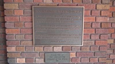
Beneath this plaque the first transcontinental railroad traversed the mighty Sierra Nevada range. The 1659 foot long summit tunnel took over 15 months of Chinese muscle and sweat to build. The Chinese painstakingly hand drilled, then blasted the . . . — — Map (db m95506) HM
History
It was a race. The Union and Central Pacific Railroads were crossing the continent with steel rails each trying to build the most miles and so get the most money from the government. The rugged Sierra and its winter climate were . . . — — Map (db m81883) HM
Boca's Railroad Roots
From 1866-68, the Central Pacific Railroad was laying tracks over the Sierra Nevada working to complete its portion of the nation's first transcontinental railroad. The railroad's Construction Camp 17, here, at the . . . — — Map (db m62048) HM
For thousands of years, people have crossed the Sierra Nevada near this place called Donner Pass.
Traveling by foot, wagon, train or automobile, the journey has always been challenging.
By Foot
Long before it’s “discovery” . . . — — Map (db m23571) HM
While construction on Sierra tunnels delayed Central Pacific, advance forces at Truckee began building forty miles of track east and west of Truckee moving all supplies by wagon and sled. Summit Tunnel was opened in December, 1867. The line reached . . . — — Map (db m23560) HM
In 1866 the Central Pacific Railroad in their push east over the Sierra Nevada set up Construction Camp 17 just downstream from here at the confluence of the Truckee River and the Little Truckee River. Camp 17 quickly became known as Boca, Spanish . . . — — Map (db m113830) HM
This building served the people of Auburn and Placer County for more than 90 years as both a passenger and freight station.
The railroad track adjacent to this historic building is the original route location for the transcontinental railroad. . . . — — Map (db m81594) HM
So named because of its location on the Bloomer Ranch, it remains virtually unchanged since its original construction in 1864. The overwhelming task of construction was undertaken by the diligent, hard working efforts of a small band of Chinese . . . — — Map (db m93971) HM
After an eleven-month delay due to political opposition and lack of money, Central Pacific tracks reached Auburn May 13, 1865, and regular service began. Government loans became available when the railroad completed its first 40 miles, four miles . . . — — Map (db m54837) HM
Central Pacific Railroad reached Colfax, formerly Illinoistown September 1, 1865, and train service began four days later. Colfax was a vital construction supply depot and junction point for stage lines for ten months. It was renamed Governor . . . — — Map (db m13081) HM
About 1000 feet from this location is the track of the Transcontinental Railroad. In 1865 thousands of Chinese in Kwantung Provence China were recruited to work on this great connection between the East and West Coast . This monument is dedicated to . . . — — Map (db m48856) HM
The western branch of the Transcontinental Railroad, the Central Pacific, laid track to this exact point on May 21, 1864.
The Central Pacific met its eastern counterpart, the Union Pacific Railroad, at Promontory Summit, Utah, on May 10, 1869. . . . — — Map (db m91108) HM
Regular freight and passenger trains began operating over the first 31 miles of Central Pacific's line to Newcastle on June 10, 1864, when political opposition and lack of money stopped further construction during that mild winter. Construction was . . . — — Map (db m11141) HM
Central Pacific reached Rocklin, 22 miles from its Sacramento Terminus, in May, 1864, when the railroad established a major locomotive terminal here. Trains moving over the Sierra were generally cut in two sections at this point, in order to ascend . . . — — Map (db m11088) HM
Central Pacific graders reached Junction, now Roseville, on November 23, 1863, crossing the line of the California Central, which began building northward from Folsom in May 1858. That line was abandoned in 1868. CP’s track reached Junction April . . . — — Map (db m11079) HM
In 1852, shortly after the Gold Rush, forward-thinking businessmen led by Charles Wilson incorporated the Sacramento Valley Railroad (SVRR), the first railroad west of Missouri. Wilson hired 28-year old Theodore Judah to design the alignment which . . . — — Map (db m214498) HM
On January 12, 1864, President Abraham Lincoln decreed that where the Central Pacific Railroad crossed Arden Creek the western base of the Sierra Nevada began. The hardships of railroad construction through mountains resulted in increased government . . . — — Map (db m18854) HM
Since the days of Sutter’s Fort, Sacramento was the trading center for much of the Central Valley, the Sierra Nevada and points beyond. As the railroad network around the capital city expanded, Sacramento merchants were able to market a greater . . . — — Map (db m201266) HM
Founded in December 1848 by John A. Sutter, Jr., Sacramento was an outgrowth of Sutter’s Fort established by his father, Captain John A. Sutter, in 1839. State Capital since 1854, it was a major distribution point during the Gold Rush. A . . . — — Map (db m11486) HM
This National City California Southern Railroad Depot, built in 1882, served as the first Pacific Coast Terminus Station of the Santa Fe Railway System's Transcontinental Railroad. The station was the West Coast general office and figured . . . — — Map (db m120892) HM
The construction of the San Joaquin River Bridge completed the last link of the Transcontinental Railroad. Building had simultaneously proceeded from the Bay Area and Sacramento and met at the San Joaquin River. The first train crossed the bridge on . . . — — Map (db m11380) HM
Two panels are mounted on the same stand.
Transcontinental Railroad
The dream of uniting America by rail began its journey to reality in June 1865 when the Union Pacific Railroad Company started laying track westward from . . . — — Map (db m79878) HM
The 100th longitudinal line west of Greenwich was the major goal set by Congress in building the first transcontinental railroad.
Construction of the Union Pacific track reached the Meridian on October 5, 1866.
To celebrate this record-breaking . . . — — Map (db m123869) HM
Here, on August 7, 1867, a band of Southern Cheyennes, led by Chief Turkey Leg, wrecked a west-bound Union Pacific freight train and handcar which preceded it.
The engineer and fireman were killed and the boxcars looted and burned.
One of the . . . — — Map (db m120893) HM
You are standing at the site of the original Union Pacific Omaha Shops.
From this point a railroad was begun that would fulfill a national destiny.
Even before Union Pacific was an American icon, it was an American dream. It was a . . . — — Map (db m58038) HM
When the Union Pacific laid track west from Omaha in 1865 the rails also followed the Great Platte River Road. The Union Pacific linked up with the Central Pacific at Promontory, Utah in 1869 to complete the nation’s first transcontinental railroad. . . . — — Map (db m50788) HM
Mile 762.7 from San Francisco
Information about this siding is limited to ambiguous notations amending Central Pacific RR survey plats and profiles.
Onsite investigations have revealed no evidence of occupation. — — Map (db m105299) HM
Mile 748.6 from San Francisco
Monument was little more than a siding and wye for the railroad, with little evidence remaining today of the railroad era.
Its name came from Monument Point, a prominent landform visible from here. Photos from . . . — — Map (db m105301) HM
Mile 765.0 from San Francisco
This site was christened Victory on April 28, 1869 when Central Pacific Workers rested for lunch after laying six miles of track during the famous laying of ten miles of track in a day. The site was later named . . . — — Map (db m105297) HM
A sharp eye can still pick out the marks of early railroad building along this rugged escarpment, even if the original iron rails and timber ties themselves are gone.
These fading remnants tell the story of a daunting engineering . . . — — Map (db m69108) HM
Mile 691.6 from San Francisco
Track-laying crews reached Bovine March 28, 1869 and established a section station. A freight platform was constructed in Bovine in 1885. The site was named after Bovine Mountain located directly north of the . . . — — Map (db m105480) HM
Mile 680.5 from San Francisco
Historic Lucin was established as a section station on July 6th, 1875. A nearby rail station originally held the name "Lucin," but the name and the services were relocated here to Historic Lucin. It also served . . . — — Map (db m105482) HM
Mile 734.1 from San Francisco
Kelton served as a section station for the Central Pacific Railroad from 1869-1942. The location was originally called Indian Creek but was soon renamed Kelton in honor of a local stockman.
The town was built . . . — — Map (db m105340) HM
Mile 712.8 from San Francisco
Track laying crews reached the site of Matlin on April 5, 1869. Matlin was used by the railroad from 1869-1904 as a section station. Chinese railroad workers built a small community next to the facilities. . . . — — Map (db m105426) HM
Mile 686.4 from San Francisco
The presence of the RR made vast areas of the rangeland available to ranchers by providing the vital link to civilization. The RR furnished an avenue for supplies and an outlet to numerous markets. This siding . . . — — Map (db m105481) HM
Mile 703.5 from San Francisco
Old Terrace is a mile east of the population center of Terrace. There was probably never a settlement here, but heavy traffic in and out of Terrance may have required a backup siding. Not many references of Old . . . — — Map (db m105430) HM
Mile 722.6 from San Francisco
The railroad siding at Ombey was completed in 1879. Within two years , a section house, tool house, and Chinese bunk and cookhouses had been constructed. The nearby facilities of Gravel Pit were abandoned in favor . . . — — Map (db m105344) HM
Mile 727.3 from San Francisco
Peplin was a small temporary occupation. Central Pacific track layers reached this point on April 9, 1869, but the earliest documented use as a siding was 1888. The remains of Peplin siding can be seen in the . . . — — Map (db m105341) HM
Mile 708.5 from San Francisco
This siding was built May 30, 1895 to accommodate increased traffic and possibly area ranchers. It appears than no support facilities were constructed at the site. Railroad records indicate that siding . . . — — Map (db m105429) HM
Mile 717.6 from San Francisco
The railroad siding at Romola was built in 1899 to meet increased rail traffic and the needs of local ranchers. The railroad was used by ranchers and cowboys as a way to move the cattle they raised to market . . . . — — Map (db m105347) HM
Terrace was the largest of the Central Pacific towns built in Utah. It was established in April 1869 as the maintenance and repair headquarters for the entire Salt Lake division. The railroad facilities here included and 8-track switchyard, a . . . — — Map (db m105434) HM
As the town grew, so did the cemetery. Accidents, illness, and old age contributed to residents of Terrace being buried here. The cemetery has been slowly deteriorating, but was in fairly good condition until 1986 when vandals stole some of the . . . — — Map (db m105433) HM
Mile 697.5 from San Francisco
This siding, built nearly 30 years after the laying of the track is evidence of ever increasing traffic and constant upgrading and improvement through the years as many as 10 trains a day used the Promontory . . . — — Map (db m105479) HM
Mile 699.8 from San Francisco
Following the abandonment of Terrace, Watercress served as a principle freight and siding for area ranchers early in the twentieth century. Railroad documents record the existence of corrals, a barn, a stock . . . — — Map (db m105437) HM
An Icon Restored
In 1965, the National Park Service assumed ownership of the aging monument, which had been damaged by years of weathering and vandalism. The interior had also been severely damaged by ground water that had wicked up into . . . — — Map (db m67076) HM
"The last rail is laid, the spike is driven. The Pacific Railroad is completed." Here at Promontory, Utah, at 12:47 P.M. on May 10, 1869, the driving of a Golden Spike completed the first Transcontinental Railroad. Climax of a dramatic . . . — — Map (db m133654) HM
Mile 739.1 from San Francisco
Elinor was largely uninhabited. It was a long siding, measuring 2,300 feet in length, and was constructed in the early twentieth century to accommodate increased rail traffic. It was possibly also used as a freight . . . — — Map (db m105339) HM
Mile 743.6 from San Francisco
Nella was an uninhabited siding built(?) in 1902 to serve local ranchers. The siding was removed in 1906, and relaid in 1916. In 191(?) a train car body and freight platform where present. — — Map (db m105308) HM
Mile 743 from San Francisco
The section station at Seco was established in 1873 to accommodate facilities moved from Ten-Mile, another section station three-and-a-half miles east. The work crews and inhabitants of Seco were mainly Chinese. . . . — — Map (db m105337) HM
Mile 746.6 from San Francisco
Ten-Mile was part of the long, circuitous route around the northern edge of the Great Salt Lake. Dry, inhospitable geography and steep railroad grades requiring helper locomotives in several locations led the . . . — — Map (db m105304) HM
As western settlement increased, the need for an overland railroad was voiced by various groups, including Utah pioneers who petitioned Congress, Mar. 1852. The Enabling Act of 1862 authorized construction. First rails laid by Central Pacific in . . . — — Map (db m35805) HM
Commissioned by the Union Pacific Railroad, the Ames Monument is a memorial to the Ames brothers, Oakes and Oliver, for their contributions to the building of the Transcontinental Railroad. Their strong support, drive and influence were . . . — — Map (db m89647) HM
At first glance, the Ames Monument may seem out of place on this high, wind-swept setting. If you step back and view the Monument from a distance, you will notice its design and shape mimic the surrounding features of the mountain landscape. The . . . — — Map (db m89645) HM
Construction of the Transcontinental Railroad across the United States was one of the most significant historic events of the 1800s. Built almost exclusively with manual labor and hand tools, the cross-country railroad took only four years to . . . — — Map (db m89646) HM
This small pine tree that seems to be growing out of solid rock has fascinated travelers since the first train rolled past on the Union Pacific Railroad. It is said that the builders of the original railroad diverted the tracks slightly to pass by . . . — — Map (db m62159) HM
The Fort Fred Steele sawmill had traveled thousands of miles by rail and wagon prior to its arrival and installation here, along the North Platte River. The Lane and Bodley 15 horsepower steam-driven sawmill began its journey through the military . . . — — Map (db m89818) HM
The bridge tender's house was constructed by the Union Pacific Railroad to serve as an employee surveillance point. The bridge tender could respond quickly to locomotive-caused fires and could remove flood debris which might damage the bridge and . . . — — Map (db m89754) HM
During construction of the Union Pacific Railroad land speculators and a large contingent of undesirables kept pace with or move ahead of the construction crews and their military escorts. Townsite speculators tried to anticipate depot locations, . . . — — Map (db m89755) HM
Construction of the Union Pacific Railroad stimulated the growth of the timber industry in southern Wyoming. Two companies began supplying ties to the railroad in 1868, but the firm of Coe and Carter was the leading supplier to the Fort Fred Steele . . . — — Map (db m89817) HM
The Union Pacific Railroad and the North Platte River are important parts of the story of Fort Fred Steele. Located where these two great resources met, the fort and the local industries surrounding it would depend upon the rails and water for . . . — — Map (db m89759) HM
Passenger travel on the Union Pacific Railroad began in July of 1868, with the first trans-continental service beginning just 10 days after the golden spike was driven on May 10, 1869 at Promontory Point in Utah. The first passenger trains were . . . — — Map (db m89915) HM
In 1901, the Fireman's Fund Insurance Company included a plat of Ft. Steel in its insurance rating of the town. The town had not grown as planned, probably due to the closeness of Rawlins and that the timber industry had started building its own . . . — — Map (db m89820) HM
In 1868 the Union Pacific Railroad was rapidly moving west with the short lived railhead towns leading the way. In early July, General Dodge ordered the citizens of Brownsville to move three miles from the river to the edge of the Dry Desert. This . . . — — Map (db m89916) HM
Part 1
Side A
The story of the Union Pacific Railroad is also a story of Wyoming and particularly Cheyenne. One cannot be told without the telling of the other. It is no exaggeration to say that Cheyenne, Fort D.A. Russell (now F.E. . . . — — Map (db m47178) HM
Before the Transcontinental Railroad connected the East and West coasts of the United States, stage coach lines transported both passengers and mail across the country. Stations along the route functioned as pit stops, where horses - tired and . . . — — Map (db m76743) HM
One of the greatest improvements by the Union Pacific Railroad occurred with the construction of Aspen Tunnel. It saved 10 miles in distance from Leroy to Evanston.
Work began on the tunnel in November 13, 1899, and was completed October 9, . . . — — Map (db m90122) HM
Nothing remains today as a reminder that Bear River City was one of the notorious "end-of-track" towns along the original Union Pacific transcontinental railroad line. Initially called Gilmer, the town was first settled by lumberjacks who arrived . . . — — Map (db m225755) HM
The most important event in the development of this area was the construction of the Union Pacific Railroad. The tracks came into Wyoming Territory in 1867. Many towns, now vanished, preceded the graders, bridge builders, tie hacks, and gandy . . . — — Map (db m90121) HM
The Muddy Creek Camp, which was northwest of this marker and on the west side of the Muddy Creek was used by Brigham Young's first group of Mormon pioneers who arrived here on July 9, 1847. Thomas Bullock reported that the brethren sang . . . — — Map (db m36573) HM
Four panels are located at the kiosk
Town of Piedmont
Located west of the kilns, the town of Piedmont started out as a logging camp supplying ties for the approaching Union Pacific Railroad in the 1860s. It also served as . . . — — Map (db m90444) HM