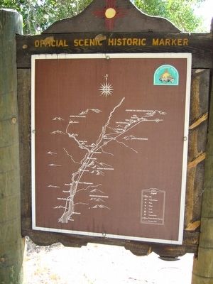
El Camino Real de Tierra Adentro Historical Markers
El Camino Real de Tierra Adentro (Spanish for "The Royal Road of the Interior Land") was a 1,600 mile (2560 kilometer) long trade route between Mexico City and San Juan Pueblo, New Mexico, from 1598 to 1882. The 404 mile (646 kilometer) section of the route within the United States was proclaimed as a National Historic Trail on October 13, 2000.
On 4th Street NW at 2nd Street NW (State Road 47), on the right when traveling south on 4th Street NW.
This 18th century Spanish settlement was established on the site of an ancient Tiwa Indian Pueblo that was destroyed following the Pueblo Revolt of 1680. The pueblo was reestablished in 1702, but in 1708 the Spanish moved its Tiwa inhabitants to . . . — — Map (db m45435) HM
On North Plaza Street NW at San Felipe Street NW, on the left when traveling west on North Plaza Street NW.
In 1706, New Mexico Governor Francisco Cuervo y Valdes founded the new Villa de Albuquerque (now spelled Albuquerque). Here, the Camino Real wound its way through a series of farming and ranching communities to a nearby ford, linking the road . . . — — Map (db m179424) HM
On Romero Street NW at Old Town Road NW, on the left when traveling south on Romero Street NW.
1706-The Villa of "Alburquerque" was founded by Don Francisco Cuervo y Valdes, Governor of the Spanish province of New Mexico. It stood on the Camino Real (Royal Road), which ran between Mexico City and Santa Fe. It became the . . . — — Map (db m45278) HM
(side one)
“Jornada De Paz”
Meaning "Journey of Peace" as the party made their expedition peaceful by not carrying weapons
In 1692 - 12 years following the 1680 Pueblo Revolt in New Mexico, the . . . — — Map (db m45444) HM
On Mountain Road NW at 19th Street NW, on the right when traveling east on Mountain Road NW.
On January 26, 1598, amid embraces and farewells, Governor Juan de Oñate left Santa Barbara, in present day Chihuahua, leading an expedition bound for New Mexico. Nearly 600 settlers accompanied him, along with Mexican Indian allies and Franciscan . . . — — Map (db m45443) HM
On Central Avenue (U.S. 66) 0.7 miles east of Paseo Del Volcan Road SW, on the right when traveling east. Reported missing.
Spanish settlers had lived here before the Pueblo Revolt of 1680, but the area was resettled when the "Villa de Albuquerque" was founded in 1706. In addition to promoting colonization, the new town was intended to provide protection from attacks . . . — — Map (db m8504) HM
One of the few battles of the Mexican War to be fought in New Mexico occured near here on Christmas Day, 1846. U.S. troops under Colonel Alexander W. Doniphan defeated a Mexican army commanded by General Antonio Ponce de León. Two days later, . . . — — Map (db m6552) HM
Stagecoaches of the Butterfield Overland Mail Co. began carrying passengers and mail from St. Louis to San Francisco, across southern New Mexico, in 1858. The 2,795-mile journey took 21-22 days. In 1861 the service was re-routed through Salt Lake . . . — — Map (db m6553) HM
Near northbound I-10 (Interstate 10) when traveling north.
Juan de Oñate, first governor of New Mexico, passed near here with his colonizing expedition in May, 1598. Traveling north, he designated official campsites (called parajes) on the Camino Real, used by expeditions that followed. In Oñate's . . . — — Map (db m6549) HM
On Dona Ana Road at State Road 320, on the right when traveling north on Dona Ana Road.
This site, named after the legendary woman, Doña Ana, is first mentioned as a paraje along the Camino Real. Spanish rested near here as they retreated from New Mexico following the Pueblo Revolt of 1680. The community was founded in 1843 as the Doña . . . — — Map (db m38178) HM
On State Road 320 at milepost 2,, 0.1 miles west of Interstate 25, on the right when traveling west.
The name of the county Doña Ana originates from Doña Ana Robledo, who died near here while fleeing south with other settlers during the 1680 Pueblo Revolt. She was buried below the peak that now bears her surname in the Robledo Mountains, so named . . . — — Map (db m38176) HM
Originally established as Santa Barbara in 1851, Apache raids drove the settlers away until 1853 when nearby Fort Thorn was established. Abandoned again in 1860 after the fort closed, it was reoccupied in 1875 and re-named for General Edward Hatch, . . . — — Map (db m24745) HM
On Interstate 25 at milepost 22.8, on the right when traveling south.
Fort Selden was established to protect settlers and railroad construction crews in the Mesilla Valley and the Jornada del Muerto from Apaches. The first regular army troops to garrison it were four companies of the black 125th Infantry. General . . . — — Map (db m45085) HM
On Interstate 25 at milepost 22.8, on the right when traveling south.
This stretch of the Camino Real leaves the Ríó Grande and cuts across 90 miles of desert with little water or shelter. Despite its difficulty, the dreaded “Journey of the Deadman” was heavily used by Spanish, Mexican, and Anglo travelers . . . — — Map (db m45083) HM
On State Road 28 at State Road 292, on the right when traveling south on State Road 28.
On November 16, 1854, a detachment from nearby Fort Fillmore raised the U.S. flag here confirming the Gadsden Purchase; thus the Gadsden territory was officially recognized as part of the United States. In 1858, the Butterfield stage began its run . . . — — Map (db m38149) HM
On Interstate 25 at milepost 22.8, on the right when traveling south.
This paraje, or stopping place, provided travelers along the Camino Real with a final opportunity to water their stock and prepare their caravans before leaving the Rio Grande Valley and entering the desolate Jornada del Muerto. Caravans on . . . — — Map (db m45084) HM
On Calle de Principal at Calle de Parian, on the right when traveling north on Calle de Principal.
The 1848 Treaty of Guadalupe Hidalgo ended the Mexican-American War, establishing Mesilla as a Mexican holding. Cura Ramon Ortiz settled families from El Paso del Norte and pre-territorial New Mexico here. Disputes over the border just north of town . . . — — Map (db m119926) HM
This stretch of the Camino Real leaves the Río Grande and cuts across 90 miles of desert with little water or shelter. Despite its difficulty, the dreaded “Journey of the Deadman” was heavily used by Spanish, Mexican, and Anglo travelers . . . — — Map (db m38205) HM
High plains of the Jornada del Muerto, elevation 4,340 feet, lie 400 feet above the Rio Grande Valley. It is a transitional area from the Basin and Range region to the west into tilted mountain ranges, such as the San Andres Mountains to the east, . . . — — Map (db m38206) HM
On Fort Selden Road, 1.4 miles west of Interstate 25, on the right when traveling west.
This paraje or resting place was named for Pedro Robledo, a member of the Juan de Oñate expedition, who was buried nearby on May 21, 1598. This camping place was a welcome sight for caravans entering or exiting the dreaded Jornada del . . . — — Map (db m38200) HM
Near Interstate 25 at milepost 22.8, on the right when traveling north.
This paraje, or stopping place, provided travelers along the Camino Real with a final opportunity to water their stock and prepare their caravans before leaving the Rio Grande Valley and entering the desolate Jornada del Muerto. Caravans on their . . . — — Map (db m38204) HM
On McNutt Road, 2.2 miles south of Racetrack Drive, on the left when traveling south.
This canyon cut here by the Rio Grande marks the crossing of the historic Camino Real, or Royal Road, to La Tierra Adentra. Trackers and traders crossed the river here to begin the arduous journey north to Santa Fe. Permanent settlement of this area . . . — — Map (db m38103) HM
On State Road 478 at State Road 227, on the left when traveling north on State Road 478.
Here the Camino Real between Santa Fe and El Paso passed along the eastern bank of the Rio Grande near a brazito, or small branch of the river that created a small island. At this paraje, or stopping place, American troops defeated a . . . — — Map (db m38148) HM
On Juan Medina Road (County Road 98) 0.1 miles east of High Road to Taos (State Road 76), on the left when traveling south.
Indians occupied the Chimayo valley centuries before the arrival of the Spaniards. The village of Chimayo, founded in the early 18th century, shortly after the reconquest of New Mexico, has been a center of the Spanish weaving tradition for over 250 . . . — — Map (db m32819) HM
On Sanctuario Drive - County 94C, 0.2 miles west of Juan Medina Road (County Road 98), on the right.
In 1816, Bernardo Abeyta and the other residents of El Potrero, then a separate community, finished this massive adobe chapel honoring Nuestro Señor de Esquípulas. It is noted for its 6-foot crucifix and its tradition of healing the sick. The . . . — — Map (db m32817) HM
On North Paseo De Onate (U.S. 84 at milepost 191), 0.5 miles north of Fairview Drive, on the right when traveling south.
When it was described by Gaspar Castano de Sosa in 1591, the Española Valley contained about ten Tewa-speaking pueblos, several of which are still occupied today. Juan de Oñate established New Mexico’s first colony here in 1598. Long on the northern . . . — — Map (db m45671) HM
On State Road 68, on the right when traveling north.
Governor Juan de Oñate set up his headquarters in San Juan Pueblo in 1598, but by 1601 he had moved the Spanish capital across the Rio Grande to Yuque-Yunque Pueblo. Named San Gabriel, it served as the seat of government until 1610, when Oñate's . . . — — Map (db m32877) HM
On Los Alamos Highway (State Road 30 at milepost 7.1) at Roller Road, on the left when traveling north on Los Alamos Highway.
Founded around the fourteenth century, Santa Clara traces its ancestry to Puye, an abandoned site of cave dwellings on the Pajarito Plateau. Increasing tensions with the Spanish led to its participation in the Pueblo Revolt of 1680. The mission . . . — — Map (db m45664) HM
On State Road 68 at County Road 60, on the left when traveling north on State Road 68.
Founded in 1875, this small farming community was named La Jolla. It was once famous for finely woven blankets. Here the Camino Real left the Rio Grande and followed a canyon northeast to Embudo Creek where it began a climb over the mountains to . . . — — Map (db m43810) HM
On State Road 313, 1.5 miles south of I-25 (State Road 313), on the right when traveling south.
Near here the Rio Grande Valley closes into a narrow pass (angostura). Control of this pass was critical to the safety of the trade along the Camino Real, so this area has been the focus of fortifications since the early 17th century. The 18th . . . — — Map (db m32800) HM
On U.S. 550 at milepost 4.2,, 0.2 miles east of Santa Fe Hills Boulevard, on the right when traveling east.
The Pueblo Indian province of Tiguex, in the area of Bernalillo, served as winter headquarters for Francisco Vásquez de Coronado in 1540-42 during his explorations of the Southwest. Bernalillo was founded after the Spanish reconquest of New Mexico . . . — — Map (db m45440) HM
On Pan American Central Highway (State Road 313) north of Denny Road, on the right when traveling north.
Archaeological research indicates that this fertile valley has been the focus of human occupation for at least 10,000 years. Soon after the Spanish colonized New Mexico in 1598, a series of estancias, or farming and ranching communities, flanked the . . . — — Map (db m45441) HM
On U.S. 550 at State Road 74, on the right when traveling west on U.S. 550.
The Keres-speaking pueblo of Santa Ana was established on its present site in 1693, as part of Diego de Vargas' reconquest of New Mexico. The spot, exposed to flooding, was poorly suited for farming, and today the residents live on their farms along . . . — — Map (db m32843) HM
On Corrales Road (State Road 448) at Jones Road, on the right when traveling south on Corrales Road.
Spanish colonization of this region, once the location of many Tiwa Indian pueblos, began in the 17th century. Corrales is named for the extensive corrals built here by Juan González, founder of Alameda. In the 18th century this rich farming . . . — — Map (db m45436) HM
On Road 88 at State Road 22, on the right when traveling east on Road 88.
The Keresan people of Santo Domingo have occupied the area of the Rio Grande Valley since prehistoric times despite several floods that have forced relocation and reconstruction of the original pueblo. Strategically located along the roads that have . . . — — Map (db m45476) HM
On U.S. 550, 1.6 miles west of Zia Boulevard, on the right when traveling west.
In 1541 an expedition from the army of Francisco Vasquez de Coronado, New Mexico's first explorer, marched south 80 leagues to investigate the pueblos along the lower Rio Grande. The group reached that part of the infamous Jornada del Muerto, now . . . — — Map (db m32826) HM
On Agua Fria Street (El Camino Real) (County Road 66) 0.2 miles west of Siler Road, on the right when traveling east.
Caravans entering and leaving Santa Fe on the Camino Real wound their way through scattered agricultural settlements south of the capital. Although this section of the Santa Fe River Valley was initially utilized as pasture for livestock, in the . . . — — Map (db m40451) HM
On Agua Fria Street (El Camino Real) (County Road 66) 0.5 miles east of Lopez Lane, on the right when traveling east.
This 19th century adobe church is dedicated to San Isidro, ploughman, patron saint of farmers and protector of crops. Christian tradition maintains that in order to allow San Isidro time for his daily prayers an angel plowed his fields. Agua Fria . . . — — Map (db m40452) HM
On State Road 502 at milepost 12.5 at Povi Kaa Drive (Road 401), on the right when traveling west on State Road 502.
In the 1500’s, migrants from the Pajarito Plateau joined their Tewa-speaking relatives at San Ildefonso. The pueblo is famous as the home of the late María Martínez and other makers of polished black pottery. The modern church, a replica of that of . . . — — Map (db m45659) HM
On South McCurdy Road (County Road 583) 0.1 miles north of Santa Cruz Road (State Road 76), on the left when traveling north.
(side one)
Santa Cruz de la Cañada
In 1695, Governor Diego de Vargas founded his first town, Santa Cruz de la Cañada, designed to protect the Spanish frontier north of Santa Fe. The church, which still stands, was constructed in . . . — — Map (db m45673) HM
1598-1890
El Camino Real (The Royal Road) sustained New Mexico's settlers from the start.
Settlers traveled north to la tierra adentro (the interior land) and back to cities in
the south. El Camino Real was a viable commercial route for . . . — — Map (db m182314) HM
Near Interstate 25 at milepost 269,, 1.5 miles west of Waldo Canyon Road (County Road 57).
(side one)
Maria Gertrudis Barceló or Doña Tules, a notorious gambler and courtesan, operated a gambling house and saloon on Burro Alley in Santa Fe. She traveled up El Camino Real from Sonora, Mexico in 1815. Bishop Jean-Baptiste Lamy . . . — — Map (db m45479) HM
On Cerrillos Road (State Road 14) west of Camino Carlos Rey, on the right when traveling north.
Santa Fe, the oldest capital city in the United States, was established in 1610 as the seat of the Spanish colonial government for the Province of New Mexico. The Palace of the Governors, used by the Spanish, Mexican, and Territorial governors, has . . . — — Map (db m45575) HM
On State Road 187 at State Road 152, on the right when traveling north on State Road 187.
To the east beyond Caballo Reservoir are the rugged Caballo Mountains, uplifted about 3 miles above the downdropped Río Grande trough, along the fault scarp at the edge of the mountains. Lowest slopes are ancient granites. Black ironstone beds are . . . — — Map (db m45107) HM
On South Broadway Street, 0.7 miles east of Interstate 25, on the right when traveling east.
In 1581, Capitán Francisco Sánchez Chamuscado took possession of this region for the King of Spain, naming it the Province of San Felipe. Significant European settlement of the area, however, did not occur until the mid-1800s. Once called Hot . . . — — Map (db m45108) HM
On North Date Street, on the left when traveling north.
In 1581, Capitan Franciso Sanchez Chamuscado took possession of this region for the King of Spain naming it Ojo de Zoquete (mud spring) in the province of San Felipe. Native Americans first used these springs for healing; in early 20th century, . . . — — Map (db m242470) HM
On Interstate 25 at milepost 166.4, on the right when traveling north.
The Camino Real wound its way below the black basaltic buttes of San Acacia, seen to the southeast. Named Acomilla, or Acomita (little Acoma) by the Spanish, these buttes form the walls of a narrow passage for the Rio Grande, along which hostile . . . — — Map (db m45215) HM
On State Road 304, 6.5 miles south of U.S. 60, on the right when traveling east.
Present-day La Joya is located near the site of an ancient Piro Indian Pueblo that the Spanish named Nueva Sevilla, or Sevilleta. During the eighteenth century, this was the southernmost settlement along the Camino Real before the travelers ended . . . — — Map (db m67105) HM
On Calle de Lemitar at Interstate 25, on the right when traveling east on Calle de Lemitar.
The Camino Real passed near here below the bluffs on the east bank of the Rio Grande. Apache raids prevented permanent Spanish settlement of this area until the early 1800s, when the village of Sabino was established on the east bank of the river . . . — — Map (db m45178) HM
Near CanAm Highway (Interstate 25 at milepost 113), 1.2 miles south of State Road 107, on the right when traveling south.
In 1582 and 1583, Antonio de Espejo and his party followed the Rio Grande north to the Bernalillo area. Espejo was trying to learn the fate of two Franciscan friars who stayed with the Pueblo Indians after the Rodriquez – Sanchez/Chamuscado . . . — — Map (db m68057) HM
Near CanAm Highway (Interstate 25 at milepost 113), 1.2 miles south of State Road 107, on the right when traveling south.
Fort Craig is on alluvial gravelly sands, derived from the mountains to the west, sloping toward Rio Grande to east. Magdalena Mountains to northwest and San Mateo Mountains to west are mainly thick piles of volcanic rocks. San Andres Mountains on . . . — — Map (db m68055) HM
Near CanAm Highway (Interstate 25 at milepost 113) south of State Road 107, on the right when traveling south.
The mountain range seen along the east bank of the Rio Grande is named after Father Cristobal de Salazar of the 1598 Juan de Onate expedition. The northern edge of the twenty-one mile range is said to resemble the profile of the good friar. This . . . — — Map (db m68056) HM
On U.S. 380 at milepost 9.3, on the right when traveling east.
In the 1860s, a coal field east of San Antonio was occasionally mined by soldiers for heating fuel and to fire their blacksmith ovens. In 1883, the Santa Fe railroad built a bridge across the Rio Grande at San Antonio and laid track to the new coal . . . — — Map (db m45175) HM
On U.S. 380 at milepost 0.4, on the right when traveling east.
Established in the mid 1600s, the mission of San Antonio de Senecú was the last outpost on the Camino Real before the Mesilla Valley to the south. Around 1820 Hispano settlers from the north re-occupied the area after the Pueblo Revolt. Conrad . . . — — Map (db m45172) HM
On U.S. 380 at milepost 2.2, on the right when traveling east.
Established in the 1840s on the east bank of the Rio Grande, San Pedro became an important trading center along the Camino Real. The sister village of San Antonio, it was once known for its extensive vineyards and other agricultural produce. The . . . — — Map (db m45174) HM
On Interstate 25 at milepost 114, on the right when traveling north.
Fort Craig was established in 1853 and garrisoned in 1854 with troops from Fort Conrad located about nine miles north. Named after Capt. Louis S. Craig, it was used to control Indian raids along the Jornada del Muerto. Troops from Fort Craig were . . . — — Map (db m45130) HM
On Interstate 25 at milepost 114, on the right when traveling north.
The mountain range seen along the east bank of the Rio Grande is named after Father Cristobal de Salazar of the 1598 Juan de Oñate expedition. The northern edge of the twenty-one mile range is said to resemble the profile of the good friar. This . . . — — Map (db m45132) HM
On Grant Street (U.S. 60), on the right when traveling east.
The Piro Indian pueblo Teypana was visited by Juan de Oñate in 1598. The people of the village reportedly supplied corn to Oñate who bestowed the name Socorro ("aid" in Spanish) on the pueblo. In 1626, the mission of Nuestra Señora de Socorro was . . . — — Map (db m38462) HM
On Terry Avenue at School of Mines Road, on the right when traveling east on Terry Avenue.
In 1598, Juan de Oñate's Spanish colonization expedition arrived here at the Piro Indian Pueblo of Pilabo, They renamed it Socorro owning to the food and shelter provided by Pilabo's inhabitants. The pueblo and its Spanish mission were destroyed . . . — — Map (db m45177) HM
On Interstate 25 at milepost 114, on the right when traveling north.
In 1541 an expedition from the army of Francisco Vásquez de Coronado, New Mexico’s first explorer, marched south 80 leagues to investigate the pueblos along the lower Río Grande. The group reached that part of the infamous Jornada del Muerto, now . . . — — Map (db m45129) HM
On Interstate 25 at milepost 114, on the right when traveling north.
Front of Marker
In 1598 the first Spanish settlers in New Mexico traveled up the Camino Real from north-central Mexico. Of the 560 people so far identified on that expedition, at least 20 percent were women. They came on foot, on wagons or . . . — — Map (db m45131) HM
On State Road 304, 3.3 miles north of U.S. 60, on the right when traveling north.
During the late 17th century, this area had become well known to the Spanish. Called La Vega de Las Nutrias, or meadow of the beavers, it was a welcome paraje, or stopping place, for caravans on the Camino Real. Eighteenth century attempts at . . . — — Map (db m67080) HM
On Church Loop at Silva Road, on the left when traveling north on Church Loop.
For centuries, the prominent cerro, or steep hill, of Tomé was a significant landmark for travelers along the Camino Real. Settled as early as 1650, this area was abandoned following the Pueblo Revolt of 1680 and remained uninhabited until the Tomé . . . — — Map (db m67077) HM
On Main Street NE (State Road 47) at Roberts Circle on Main Street NE.
This community traces its beginnings to the hacienda established by Captain Francisco Valencia along this section of the Camino Real by the mid-17th century. Abandoned during the Pueblo Revolt of 1680, the area was resettled in 1740 by Christian . . . — — Map (db m67073) HM
On Peralta Boulevard at State Road 47, on the right when traveling north on Peralta Boulevard.
One of the last skirmishes of the Civil War in New Mexico took place here on April 15, 1862. The Sibley Brigade, retreating to Texas, camped at the hacienda of Governor Henry Connelly, a few miles from Peralta. Here the Confederates were routed by . . . — — Map (db m24314) HM
On North Oregon Street at Mills Avenue, on the right when traveling north on North Oregon Street.
The regal highway extending between his Catholic majesty's far flung kingdoms of New Spain, from Mexico City to the Kingdom of New Mexico, passed here. From 1581 onward it was the route followed by conqueror, padre, merchant, adventurer and settler. . . . — — Map (db m239454) HM
On South El Paso Street at Pioneer Plaza, on the right when traveling north on South El Paso Street.
English:
Fray García was born in Old Castile, Spain and traveled to Mexico in 1629 where he became a Franciscan priest serving in the Province of New Mexico. In 1659 he established the Manso Indian Mission of Our Lady of Guadalupe at the . . . — — Map (db m37913) HM
On West Old Paisano Drive, 0.2 miles south of Ruhlen Court, on the right when traveling south.
For more than 200 years the Camino Real, or Royal Road, was the major route for transporting commercial goods from Mexico City and Chihuahua to Santa Fe and Taos. First traveled by Juan de Oñate during his 1598 expedition to New Mexico, the Camino . . . — — Map (db m118283) HM
San Elizario was established in 1789 on the former site of Hacienda de Los Tiburcios as a Spanish Colonial Fort known as the Presidio of San Elceario. The Presidio was moved from its former location (approx. 37 mi.S) in response to requests from . . . — — Map (db m118275) HM
On San Elizario Road at Church Street, on the right when traveling north on San Elizario Road.
Named for the 13th-century French patron of the military, St. Elzear, Capilla de San Elzeario was established as part of the Spanish military garrison of Presidio de San Elzeario (also Elceario, later Elizario) when it . . . — — Map (db m118284) HM
For more than 200 years the Camino Real, or Royal Road, was the major route for transporting commercial goods from Mexico City and Chihuahua to Santa Fe and Taos. First traveled by Juan de Oñate during his 1598 expedition to New Mexico, the Camino . . . — — Map (db m201921) HM
On South Nevarez Road, on the left when traveling south.
Site of the mission and pueblo of Nuestra Señora de la Concepción del Pueblo de Socorro established by Don Antonio de Otermín and Father Fray Francisco Ayeta, O.F.M. in 1683. Maintained by Franciscan missionaries for the civilizing and . . . — — Map (db m118295) HM
On South Nevarez Road, on the left when traveling south.
For more than 200 years the Camino Real, or Royal Road, was the major route for transporting commercial goods from Mexico City and Chihuahua to Santa Fe and Taos. First traveled by Juan de Oñate during his 1598 expedition to New Mexico, the Camino . . . — — Map (db m118282) HM
On Benito Juárez just north of Avenida Francisco I. Madero, on the right when traveling north.
Ex-Escuela Pía o de Cristo El Camino Real de Tierra Adento una ruta con historia Sus antecedentes se remontan a la Escuel Pía, construida por orden de don Francisco de Rivera y Gutiérrez, como otra de beneficiencia, hacia fines de . . . — — Map (db m145592) HM
On República de Brasil just north of Calle República de Venezuela, on the left when traveling north.
Camino Real de Tierra Adentro Patrimonio Mundial De este sitio en el que estuvo la aduana de México, hace 400 años partía el Camino Real de Tierra Adentro, uniendo las poblaciones de México, Tepotzotlán, San Juan del Río, . . . — — Map (db m122229) HM
On Avenida Manuel del Mazo just north of José Canal, on the left when traveling north.
El Camino Real de Tierra Adentro ha sido inscrito en la Lista del Patrimonio Mundial en virtud de la Convención para la Protección del Patrimonio Mundial Cultural y Natural. La inscripción en esta Lista consagra el Valor Universal . . . — — Map (db m124082) HM
On Carretera Aculco-Arroyo Zarco, on the left when traveling east.
Camino Real Tierra Adentro El llamado "Camino Real de Tierra Adentro" es un proyecto cultural que inició el Instituto Nacional de Antropología e Historia, INAH, en colaboración con los gobiernos estatales involucrados y con el de la . . . — — Map (db m153193) HM
Near General Ignacio Zaragoza just east of Virreynal, on the right when traveling north.
El Camino Real de Tierra Adentro ha sido inscrito en la Lista del Patrimonio Mundial en virtud de la Convención para la Protección del Patrimonio Mundial Cultural y Natural. La inscripción en esta Lista consagra el Valor Universal . . . — — Map (db m125864) HM
On Avenida Insurgentes just west of Avenida del Trabajo, on the right when traveling west.
Camino Real de Tierra Adentro El llamado “Camino Real de Tierra Adentro” es un proyecto cultural que inició el Instituto Nacional de Antropología e Historia, INAH, en colaboración con los gobiernos estatales involucrados y . . . — — Map (db m125771) HM
On Calle Calzada de los Héroes just west of Malecón del Río de los Gómez, on the left when traveling west.
Calzada de los Héroes Octubre de 1833 El jefe político Julián de Obregón propone la construcción de una calzada para embellecer la principal entrada de la ciudad y determina para ello una serie de contribuciones tanto de las . . . — — Map (db m128393) HM
On San Antonio Abad just north of San Rafael, on the right when traveling north. Reported missing.
El Camino Real de Tierra Adentro ha sido inscrito en la Lista del Patrimonio Mundial en virtud de la Convención para la Protección del Patrimonio Mundial Cultural y Natural. La inscripción en esta Lista consagra el Valor Universal . . . — — Map (db m154412) HM
On Calle Cuna de Allende just south of Calle Correo, on the right when traveling south.
1555 - 2005 El Gobierno del Estado de Guanajuato El Honorable Ayuntamiento de San Miguel de Allende y pueblo en general rinden homenaje a su insigne fundador Fray Juan de San Miguel En los 450 años de su muerte Evangelizador ejemplar que . . . — — Map (db m98707) HM
On Jardín Hidalgo just east of Lerdo de Tejada, on the left when traveling east.
El Camino Real de Tierra Adentro ha sido inscrito en la Lista del Patrimonio Mundial en virtud de la Convención para la Protección del Patrimonio Mundial Cultural y Natural. La inscripción en esta Lista consagra el Valor Universal . . . — — Map (db m138503) HM
On Benito Juárez just north of Dr. Mariano Azuela, on the right when traveling north.
Camino Real de Tierra Adentro El Camino Real de Tierra Adentro ha sido inscrito en la Lista del Patrimonio Mundial en virtud de la Convención para la Protección del Patrimonio Mundial Cultural y Natural. La inscripción en esta Lista . . . — — Map (db m163985) HM
On Unnamed road just south of Carretera El Paraíso – Carretera Federal 57 (Route 500), on the left when traveling west.
Este camino, parte del primer itinerario cultural terrestre trazado por parte de los Españoles en América, conocido como Camino Real de Tierra Adentro, ha sido inscrito en la lista de Patrimonio Munidal de la UNESCO por su valor . . . — — Map (db m113900) HM
Near Margarita Maza Juárez just north of Guadalupe Victoria, on the left when traveling north.
El Camino Real de Tierra Adentro ha sido inscrito en la Lista del Patrimonio Mundial en virtud de la Convención para la Protección del Patrimonio Mundial Cultural y Natural. La inscripción en esta Lista consagra el Valor Universal . . . — — Map (db m154013) HM
El Camino Real de Tierra Adentro ha sido inscrito en la Lista del Patrimonio Mundial en virtud de la Convención para la Protección del Patrimonio Mundial Cultural y Natural. La inscripción en esta Lista consagra el Valor Universal . . . — — Map (db m90407) HM
On Calle Benito Juárez Norte at Calle Francisco I. Madero on Calle Benito Juárez Norte.
El Camino Real de Tierra Adentro ha sido inscrito en la Lista del Patrimonio Mundial en virtud de la Convención para la Protección del Patrimonio Mundial Cultural y Natural. La inscripción en esta Lista consagra el Valor Universal Excepcional del . . . — — Map (db m100295) HM
On Avenida Benito Juárez just east of Calle Ignacio Allende, on the right when traveling east.
El Camino Real de Tierra Adentro ha sido inscrito en la Lista del Patrimonio Mundial en virtud de la Convención para la Protección del Patrimonio Mundial Cultural y Natural. La inscripción en esta Lista consagra el Valor Universal . . . — — Map (db m156314) HM
On Calle Mariano Jiménez just west of Calle Reforma, on the left when traveling west.
"El Camino Real de Tierra Adentro" Camino de la Plata
Era el vínculo entre la Ciudad de México y la villa de Santa Fe, en la norteña provincia de Nuevo México, adentrándose hacia el norte en la "tierra ignota" donde las rancherías eran . . . — — Map (db m109156) HM
Near Hermenegildo Galeana just east of Avenida Independencia, on the left when traveling east.
El Camino Real de Tierra Adentro El Camino Real de Tierra Adentro ha sido inscrito en la Lista del Patrimonio Mundial en virtud de la Convención para la Protección del Patrimonio Mundial Cultural y Natural. La inscripción en esta . . . — — Map (db m132459) HM