By Bill Kirchner, July 22, 2011
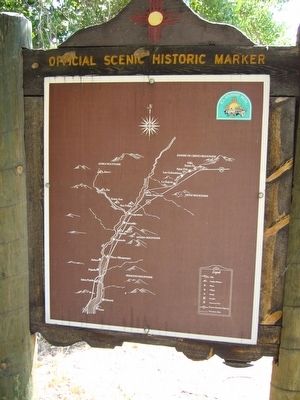
Rear of Alameda Marker
GEOGRAPHIC SORT WITH USA FIRST Geographic Sort Title Sort Marker Number Sort Marker Number Sort N Marker Number Sort T Publication Order Sort Publication Order Sort A Erected Year Sort Most Viewed Sort Most Recent-Interest Sort Most Recently Changed Sort SEE FAQ #33 FOR DESCRIPTIONS
On 4th Street NW at 2nd Street NW (State Road 47), on the right when traveling south on 4th Street NW.
On North Plaza Street NW at San Felipe Street NW, on the left when traveling west on North Plaza Street NW.
On Romero Street NW at Old Town Road NW, on the left when traveling south on Romero Street NW.
Near Mountain Road NW at Old Town Road NW.
On Mountain Road NW at 19th Street NW, on the right when traveling east on Mountain Road NW.
On Central Avenue (U.S. 66) 0.7 miles east of Paseo Del Volcan Road SW, on the right when traveling east. Reported missing.
Near Interstate 10 when traveling north.
Near northbound I-10 (Interstate 10) when traveling north.
On Dona Ana Road at State Road 320, on the right when traveling north on Dona Ana Road.
On State Road 320 at milepost 2,, 0.1 miles west of Interstate 25, on the right when traveling west.
On Interstate 25 at milepost 22.8, on the right when traveling south.
On Interstate 25 at milepost 22.8, on the right when traveling south.
On State Road 28 at State Road 292, on the right when traveling south on State Road 28.
Paid Advertisement
On Interstate 25 at milepost 22.8, on the right when traveling south.
On Calle de Principal at Calle de Parian, on the right when traveling north on Calle de Principal.
Near Interstate 25 at milepost 22.8.
Near Interstate 25 at milepost 27.
On Fort Selden Road, 1.4 miles west of Interstate 25, on the right when traveling west.
Near Interstate 25 at milepost 22.8, on the right when traveling north.
On McNutt Road, 2.2 miles south of Racetrack Drive, on the left when traveling south.
On State Road 478 at State Road 227, on the left when traveling north on State Road 478.
On Juan Medina Road (County Road 98) 0.1 miles east of High Road to Taos (State Road 76), on the left when traveling south.
On Sanctuario Drive - County 94C, 0.2 miles west of Juan Medina Road (County Road 98), on the right.
On North Paseo De Onate (U.S. 84 at milepost 191), 0.5 miles north of Fairview Drive, on the right when traveling south.
On State Road 68, on the right when traveling north.
On Los Alamos Highway (State Road 30 at milepost 7.1) at Roller Road, on the left when traveling north on Los Alamos Highway.
On State Road 68 at County Road 60, on the left when traveling north on State Road 68.
On State Road 313, 1.5 miles south of I-25 (State Road 313), on the right when traveling south.
On U.S. 550 at milepost 4.2,, 0.2 miles east of Santa Fe Hills Boulevard, on the right when traveling east.
Paid Advertisement
On Pan American Central Highway (State Road 313) north of Denny Road, on the right when traveling north.
On U.S. 550 at State Road 74, on the right when traveling west on U.S. 550.
On Corrales Road (State Road 448) at Jones Road, on the right when traveling south on Corrales Road.
On Road 88 at State Road 22, on the right when traveling east on Road 88.
On U.S. 550, 1.6 miles west of Zia Boulevard, on the right when traveling west.
On Agua Fria Street (El Camino Real) (County Road 66) 0.2 miles west of Siler Road, on the right when traveling east.
On Agua Fria Street (El Camino Real) (County Road 66) 0.5 miles east of Lopez Lane, on the right when traveling east.
On State Road 502 at milepost 12.5 at Povi Kaa Drive (Road 401), on the right when traveling west on State Road 502.
On South McCurdy Road (County Road 583) 0.1 miles north of Santa Cruz Road (State Road 76), on the left when traveling north.
Near Interstate 25 at milepost 269,, 1.5 miles west of Waldo Canyon Road (County Road 57).
On Cerrillos Road (State Road 14) west of Camino Carlos Rey, on the right when traveling north.
On State Road 187 at State Road 152, on the right when traveling north on State Road 187.
On South Broadway Street, 0.7 miles east of Interstate 25, on the right when traveling east.
On North Date Street, on the left when traveling north.
On Interstate 25 at milepost 166.4, on the right when traveling north.
Paid Advertisement
On State Road 304, 6.5 miles south of U.S. 60, on the right when traveling east.
On Calle de Lemitar at Interstate 25, on the right when traveling east on Calle de Lemitar.
Near CanAm Highway (Interstate 25 at milepost 113), 1.2 miles south of State Road 107, on the right when traveling south.
Near CanAm Highway (Interstate 25 at milepost 113), 1.2 miles south of State Road 107, on the right when traveling south.
Near CanAm Highway (Interstate 25 at milepost 113) south of State Road 107, on the right when traveling south.
On U.S. 380 at milepost 9.3, on the right when traveling east.
On U.S. 380 at milepost 0.4, on the right when traveling east.
On U.S. 380 at milepost 2.2, on the right when traveling east.
On Interstate 25 at milepost 114, on the right when traveling north.
On Interstate 25 at milepost 114, on the right when traveling north.
On Grant Street (U.S. 60), on the right when traveling east.
On Terry Avenue at School of Mines Road, on the right when traveling east on Terry Avenue.
On Interstate 25 at milepost 114, on the right when traveling north.
On Interstate 25 at milepost 114, on the right when traveling north.
On State Road 304, 3.3 miles north of U.S. 60, on the right when traveling north.
On Church Loop at Silva Road, on the left when traveling north on Church Loop.
Paid Advertisement
On Main Street NE (State Road 47) at Roberts Circle on Main Street NE.
On Peralta Boulevard at State Road 47, on the right when traveling north on Peralta Boulevard.
On North Oregon Street at Mills Avenue, on the right when traveling north on North Oregon Street.
Near South Zaragoza Road at Alameda Avenue (State Highway 20) when traveling south.
On South El Paso Street at Pioneer Plaza, on the right when traveling north on South El Paso Street.
On West Old Paisano Drive, 0.2 miles south of Ruhlen Court, on the right when traveling south.
Near San Elizario Road at Church Street.
On San Elizario Road at Church Street, on the right when traveling north on San Elizario Road.
Near San Elizario Road at Church Street.
On South Nevarez Road, on the left when traveling south.
On South Nevarez Road, on the left when traveling south.
On Benito Juárez just north of Avenida Francisco I. Madero, on the right when traveling north.
On República de Brasil just north of Calle República de Venezuela, on the left when traveling north.
On Avenida Manuel del Mazo just north of José Canal, on the left when traveling north.
On Carretera Aculco-Arroyo Zarco, on the left when traveling east.
Near General Ignacio Zaragoza just east of Virreynal, on the right when traveling north.
Paid Advertisement
On Avenida Insurgentes just west of Avenida del Trabajo, on the right when traveling west.
On Calle Calzada de los Héroes just west of Malecón del Río de los Gómez, on the left when traveling west.
On San Antonio Abad just north of San Rafael, on the right when traveling north. Reported missing.
On Calle Cuna de Allende just south of Calle Correo, on the right when traveling south.
On Jardín Hidalgo just east of Lerdo de Tejada, on the left when traveling east.
On Benito Juárez just north of Dr. Mariano Azuela, on the right when traveling north.
On Unnamed road just south of Carretera El Paraíso – Carretera Federal 57 (Route 500), on the left when traveling west.
Near Margarita Maza Juárez just north of Guadalupe Victoria, on the left when traveling north.
On Calle Benito Juárez Norte at Calle Francisco I. Madero on Calle Benito Juárez Norte.
On Avenida Benito Juárez just east of Calle Ignacio Allende, on the right when traveling east.
On Calle Mariano Jiménez just west of Calle Reforma, on the left when traveling west.
Near Hermenegildo Galeana just east of Avenida Independencia, on the left when traveling east.