The Desert Training Center was established by General George S. Patton Jr., to prepare American troops for battle during World War II. It covered 18,000 square miles and was the largest military training ground ever to exist. Located in the Mojave Desert it included areas from Nevada, Arizona and Southern California.
On Broadway Avenue (Arizona Route 72 at milepost 27) south of Main Street, on the right when traveling west.
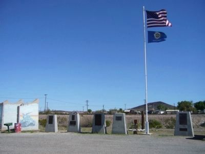
Camp Bouse
September 1943 to March 1944
"The Kid Battalion"
From Normandy to the Elbe:
•Normandy
•Northern France
•Ardennes
•Rhineland
•Central Europe — — Map (db m78563) HM
On Broadway Avenue (Arizona Route 72 at milepost 27) south of Main Street, on the right when traveling west.
Dedicated to the men who gave time in their lives to serve honorably and courageously for our country. We take this moment in time to recognize their achievements which were done with pride and dignity.
* * *
Campaigns
Ardennes - Alsace - . . . — — Map (db m29160) HM
On Broadway Avenue (Arizona Route 72 at milepost 27) south of Main Street, on the right when traveling west.
Campaigns
Ardennes, Rhineland and Central Europe
The 739th Tank Battalion was activated in March 1943 at Fort Lewis, Washington. The officers were from various states, the enlisted personnel from Oklahoma, Texas and Louisiana.
The . . . — — Map (db m78558) HM
On Broadway Avenue (Arizona Route 72 at milepost 27) south of Main Street, on the right when traveling west.
The 740th tank battalion was activated at Fort Knox, Ky. on March 1, 1943. It trained at Fort Knox and at Camp Bouse, Az. as a canal defense light (CDL) unit and as a standard medium tank battalion from October 15, 1943 to April 24, 1944 then sailed . . . — — Map (db m78562) HM
On Broadway Avenue (Arizona Route 72 at milepost 27) south of Main Street, on the right when traveling west.
General George Patton established Camp Bouse in 1943 in the Butler Valley as the site for training over 5,500 carefully screened and qualified volunteers. These soldiers were trained to use a highly secret weapon called the Canal Defense Light. . . . — — Map (db m29165) HM
On Broadway Avenue (Arizona Route 72 at milepost 27) south of Main Street, on the right when traveling west.
Camp Bouse was established in Butler Valley 30 miles behind this monument in Sept. of 1943. It was one of twelve such camps built in the southwestern deserts to harden and train United States troops for service on the battlefields of World War II. . . . — — Map (db m78566) HM
On Broadway Avenue (Arizona Route 72 at milepost 27) south of Main Street, on the right when traveling west.
Campaigns
Central Europe Northern France Rhineland
The 701st tank battalion was activated 3/28/43 at Camp Campbell, KY. Here 553 young men and officers began their journey into history. These men began their basic training and for many saw . . . — — Map (db m78564) HM
On Broadway Avenue (Arizona Route 72 at milepost 27) south of Main Street, on the right when traveling west.
Activated 1 April, 1943 at Camp Perry, OH. Completed basic training and then sent to Ft. Knox, KY. Unit then assigned to Camp Bouse, AZ arriving there 9 November, 1943. Maintaining operation of special tanks named "Leaflets" was specific assignment. . . . — — Map (db m78557) HM
On Broadway Avenue (Arizona Route 72 at milepost 27) south of Main Street, on the right when traveling west.
United States Army
World War II
1924 – 2002
Whose dedication to the memory of his brothers in
arms, who fell in the Battle of the Ardennes, made this
historical park possible. — — Map (db m78542) HM
On Broad Street (Arizona Route 72 at milepost 27) south of Main Street, on the right when traveling west.
He was our drinking buddy
While on duty
He drank our beer
He was
Full of good cheer
And went to the nurses' quarters around the bend
And came to an untimely end,
Of the Colonel, he was unaware
That it would be the crime of all time . . . — — Map (db m78536) HM
On Broadway Avenue (Arizona Route 72 at milepost 27) south of Main Street, on the right when traveling west.
We bring to a close
We tried to find
We must now impose
Units not found
748th Tank Battalion
150th Station Hospital
538th Ordnance Company
166th Quartermaster
629th Quartermaster — — Map (db m29161) HM
On Broadway Avenue (Arizona Route 72 at milepost 27) south of Main Street, on the right when traveling west.
In honored memory of those soldiers of the battalion who trained here at Camp Bouse and gave their lives in combat to preserve the freedom of the United States and to set the Peoples of Europe free.
Headquarters Company
Donald D. . . . — — Map (db m78537) HM
On Ave 64E near Interstate 8, on the left when traveling south.
Camps Hyder & Horn were established 10 miles north of Dateland in the fall of 1943. They were 2 of 15 desert camps built to harden and train United States Troops for service in World War II. The Desert Training Center was a simulated theater of . . . — — Map (db m78546) HM
On East Imperial Dam Road, 0.5 miles west of U.S. 95, on the right when traveling east.
Camp Laguna operated from April 1942 to April 1944. It was one of twelve such camps built in the southwestern deserts to train United States troops during World War II.
The Desert Training Center, a simulated theater of operations, included . . . — — Map (db m29061) HM
On Sidewinder Road North at Tucker Road, on the right when traveling south on Sidewinder Road North.
Camp Pilot Knob was a unit of the Desert Training Center, established by General George S. Patton Jr., to prepare American troops for battle during World War II. It was the largest military training ground ever to exist. At the peak of activity here . . . — — Map (db m50590) HM
On Chiriaco Road, on the right when traveling west.
The Camp Young Airstrip was established at this site in March 1942 by order of General George S. Patton. It was used to provide Camp Young with supplies and other essential material. It supported air transportation for the command staff of the . . . — — Map (db m78550) HM
On Chiriaco Road, on the right when traveling west.
This monument is dedicated to the men and women of the United States Army who were trained here at the Desert Training Center during World War II. — — Map (db m78559) HM
Near Chiriaco Road (Business Interstate 10) just north of Summit Road, on the left when traveling east.
The D.T.C was established by Major General George S. Patton Jr. in response to a need to train American combat troops for battle in North Africa during World War II. The camp, which began operation in 1942 covered 18,000 square miles. It was the . . . — — Map (db m50700) HM
On Chiriaco Road, on the right when traveling east.
Joseph L. Chiriaco came to California from Alabama in 1925. His work as a surveyor for the Los Angeles Bureau of Water and Power and later for the Metropolitan Water District on the Colorado River aqueduct, begun in 1931, brought him to the desert . . . — — Map (db m78543) HM
Near Chiriaco Road north of Interstate 10, on the left when traveling east.
[This is a four sided monument displaying three different markers:]
Front - Facing West:
Desert Training Center
* Camp Young *
Maj. Gen. George S. Patton Jr., U.S. Army, selected Camp Young as headquarters site for the Desert . . . — — Map (db m32139) HM
On Ragsdale Road east of Eagle Mountain Road, on the right when traveling west. Reported missing.
During the opening days of the World War II, more than 18,000 square miles of the Arizona and California desert were designated by the U.S. Army as a military training facility. The facility, conceived by General George Patton and referred to as the . . . — — Map (db m78512) HM
On California Route 177 at milepost 17 at Coxcomb Monument Road, on the left when traveling north on State Route 177. Reported missing.
Camp Coxcomb was established at this site in the Spring of 1942. It was one of fifteen such camps built in the southwestern deserts to harden and train United States troops for service on the battlefields of World War II. The Desert Training Center . . . — — Map (db m78513) HM
On Cottonwood Springs Road at unknown dirt road, on the right when traveling north on Cottonwood Springs Road.
Camp Young, named after Lt. Gen. S.B.M. Young, the 1st Army Chief of Staff, was established at this site in the Spring of 1942. It was one of twelve such camps built in the southwestern deserts to harden and train United States Troops for service to . . . — — Map (db m78581) HM
On Interstate 40, 6 miles east of the Essex Road Interchange, on the right when traveling east.
Camp Clipper was established at a site that reached
From Essex Road to this location in the spring of
1942. It was one of twelve such camps built in the
Southwestern Desert to harden and train United
States troops for service on the . . . — — Map (db m72258) HM
On Lanfair Road, 0.1 miles north of Goffs Road, on the left when traveling north.
The U. S. Army maintained a camp at Goffs 1942-1944. Goffs was an important railhead, supply point, hospital, and for three months in 1942 Headquarters of the 7th Infantry Division. That unit went on to distinguish itself in combat in the Aleutians . . . — — Map (db m78523) HM
On U.S. 95 at milepost 66,, 10 miles north of Interstate 40, on the right when traveling north.
Camp Ibis was established at this site in the spring of 1942 – one of eleven such camps built in the California – Arizona Desert to harden and train United States Troops for service on the battlefields of World War II.
The 440th AAA . . . — — Map (db m78585) HM
On California Route 62 at milepost 90.5, on the right when traveling east.
Camp Granite was established at this site in the spring of 1942. It was one of fifteen such camps built in the southwestern deserts to harden and train United States troops for service on the battlefields of World War II. The Desert Training Center . . . — — Map (db m83038) HM
On Desert Center - Rice Road (California Route 62 at milepost 90.7), on the left when traveling east. Reported missing.
Iron Mountain divisional camp was established at this site in the spring of 1942. One of eleven such camps built in the California-Arizona desert to harden and train United States troops for service on the battlefields of World War II. The first . . . — — Map (db m77424) HM
On Aqueduct Road (Route 62 at milepost 112.4), on the right when traveling east.
Camp Rice was established at this site in the spring of 1942. It was one of twelve such camps built in the southwestern deserts to harden and train United States troops for service on the battlefields of World War II. The Desert Training Center was . . . — — Map (db m209934) HM
Near Veterans Memorial Highway (U.S. 95 at milepost 9) near Piute Valley Drive, on the right when traveling south.
Originally known as Stage Field, this was an outlying airfield of Camp Ibis, one of the eleven camps established within the Desert Training Center, California-Arizonan Maneuver Area during World War II. Developed by General George S. Patton, Jr., . . . — — Map (db m78522) HM