Markers and plaques recording the 1758 British expedition through Pennsylvania to Fort Duquesne during the French and Indian War. Named for expedition commander General John Forbes.
On Saltsburg Road (Pennsylvania Route 380) at Frankstown Road, on the right when traveling east on Saltsburg Road.
Bouquet Camp, supply base in the Forbes' campaign against the French holding Fort Duquesne in 1758, was near here. Named in honor of Colonel Bouquet, second-in-command and builder of Forbes Road. — — Map (db m40879) HM
On Saltsburg Road (Pennsylvania Route 380) at Frankstown Road, on the right when traveling east on Saltsburg Road.
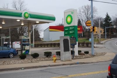
The Bouquet Encampment was located three miles east of this place which marks the farthest Northern point of the Forbes Road which leads Westward to Fort Duquesne
97 miles from Bedford — — Map (db m40884) HM
Near Commonwealth Place north of Fort Pitt Boulevard. Reported permanently removed.
Fort Duquesne
End of Forbes Road
Occupied by General Forbes
November 25, 1758 and by him named
Pittsburgh.
His victory determined the destiny of the
Great West and established Anglo-Saxon
supremacy in the United States.
"His name . . . — — Map (db m42022) HM
On Old Frankstown Road (Pennsylvania Route 2066) 0.3 miles east of Center Road, on the right when traveling west.
The last base of General Forbes' army. After crossing nearly “two hundred miles of wild and unknown country,” the army entered Fort Duquesne on November 25, 1758. — — Map (db m40883) HM
On Juliana Street at Penn Street, on the right when traveling south on Juliana Street.
Formed on March 9, 1771 from Cumberland County, it first embraced most of western Pennsylvania. Named for its county seat (formerly Raystown) incorporated 1795. In 1758, Fort Bedford was erected here, and Forbes Road - to become a major highway . . . — — Map (db m13990) HM
On West Pitt Street at Juniata Street, on the right when traveling west on West Pitt Street.
Depot of supplies assembling place of an army of nearly eight thousand men and the starting point of General John Forbes' Expedition for the possession of Fort Duquesne. The road leads Westward to the Forks. — — Map (db m52666) HM
On Lincoln Highway (U.S. 30) at Pennsylvania Route 31 on Lincoln Highway.
This intersection marks the point where Forbes Road
of 1758 diverged from the path cut by Col. Burd in
1755. The Forbes Road led through the wilderness
west toward Ligonier from this point. — — Map (db m59734) HM
On Lincoln Highway (U.S. 30) at Pennsylvania Route 31 on Lincoln Highway.
The Forks
The Road cut by Colonel James Burd
in 1755 and the Forbes Road diverge here,
Forbes Road leading southwestward to Shawnee
Cabins Encampment 4 1/2 miles from Fort Bedford. — — Map (db m166740) HM
On Lincoln Highway (U.S. 30) 0.3 miles west of Dell Road, on the right when traveling west.
At the Juniata Crossings, half a mile north of here, General Forbes erected a small stockade in 1758 to protect the communications of his army moving west to attack Fort Duquesne. — — Map (db m52663) HM
On Lincoln Highway (U.S. 30) 0.2 miles west of Market Street (Pennsylvania Route 96), on the right when traveling west.
Shawnee Cabins Encampment
At this point
the Forbes Road
leads southwestward
to
the eastern slope
of
the Allegheny Mountains
8 1/3 miles from Fort Bedford — — Map (db m49562) HM
To capture Fort Duquesne, General Forbes marched an army, in 1758, from his main base at Carlisle to the forks of the Ohio. He followed as closely as he could with army wagons, the Raystown Indian and Traders Path, widened by axemen under Colonel . . . — — Map (db m30322) HM
On W High Street (U.S. 11), on the right when traveling west. Reported missing.
In 1758, after three years of war in North America with the French and Indian alliance, the British Empire launched the Forbes Expedition. The campaign began in Carlisle, the county seat for territory that extended to the Ohio River. The British . . . — — Map (db m166741) HM
On Great Cove Road (U.S. 522) 0.2 miles west of Grist Mill Road, on the right when traveling west.
Just east of here is the junction of the two branches of the Raystown Path: a mountain shortcut by way of Fannettsburg, and Gen. Forbes road through Cowan Gap. From here Forbes route is marked by towns named for his forts: Littleton, Bedford, . . . — — Map (db m19517) HM
On Lincoln Highway (U.S. 30) 0.5 miles east of New Baltimore Road, on the right when traveling east.
"The fort on the top of Allegheny Hill" was erected in 1758 during the Gen. Forbes expedition against Fort Duquesne. The site is marked half a mile northeast of here, near the head of Breastwork Run. — — Map (db m59760) HM
On Lincoln Highway (U.S. 30) near Willison Road, on the right when traveling west.
Good forage found at open camps such as this on the Raystown Path, led General Forbes to prefer this route to Braddock's Road. Site of Fort Dudgeon (Tomahawk Camp) is a short distance to the north. — — Map (db m52702) HM
On Lincoln Highway (U.S. 30) at Whistler Road (Pennsylvania Route 403) on Lincoln Highway.
A fortified supply depot known as the Stony Creek encampment or fort was a little north of here. The route then leads north to the foot of Laurel Hill, the site of Tomahawk camp. — — Map (db m60109) HM
On Lincoln Highway (U.S. 30) 0.2 miles east of Buckstown Road.
Named for Edmund Cartlidge, Indian trader. A camp located here, on the Raystown Path, provided good grass for the horses of General Forbes' army in 1758. The site of the redoubt is marked two and a half miles north of here. — — Map (db m21559) HM
On Lincoln Highway (U.S. 30) 0.1 miles west of Technology Way (Pennsylvania Route 981), on the right when traveling east.
George Washington in 1758 set up a camp a mile north of this point while building Forbes Road. In 1774 Fort Shippen was built at the same site. — — Map (db m48079) HM
On East Main Street at Market Street, on the right when traveling east on East Main Street.
Fort Ligonier
Built by order of General Forbes. Was located 200 yards west of this marker. The road leads south-westward to 12 mile encampment. Eminent service was rendered here by Colonel Henry Bouquet and Colonel John Armstrong and in . . . — — Map (db m48072) HM
The first English fort west of the Alleghany Mountains was built five hundred feet south-east of this spot, in 1758 by order of General John Forbes, and named in honor of Lord John Ligonier.
Here General Forbes with the aid of Colonels George . . . — — Map (db m48076) HM
On William Penn Highway (U.S. 22), on the right when traveling east.
On the hill one mile south was located the Washington Camp. This base for Forbes Road was built Nov. 1758 by Col. George Washington, "Commanding the Troops to ye Westward," on the order of Colonel Henry Bouquet. — — Map (db m43752) HM
On William Penn Highway (U.S. 22) at Laird Road, on the right when traveling west on William Penn Highway.
On the hill one mile south was located the Washington Camp. This base for Forbes Road was built Nov. 1758 by Col. George Washington, "Commanding the Troops to ye Westward," on the order of Colonel Henry Bouquet. — — Map (db m43753) HM
On Old William Penn Highway east of Sardis Road, on the left when traveling east.
Turtle Creek Defile
Two and one half miles
to the eastward
was located the
Washington Camp
The Forbes Road leads
northwestward to
the Bouquet Encampment — — Map (db m225754) HM