Near Howe Street near Pleasant Valley Avenue, on the right when traveling east.
Marker:
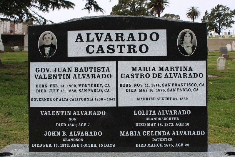
Governor Juan Bautista Alvarado
02/14/1809 – 7/13/1882
Juan Bautista Valentin Alvarado y Vallejo was born in Monterey, Alta California under Spanish rule. His family came with the Portola-Serra Expedition to settle Alta . . . — — Map (db m220002) HM
On La Cienega Boulevard south of Gregory Way, on the right when traveling south.
The expedition of Don Gaspar de Portolá from Mexico passed this way en route to Monterey to begin the Spanish colonization of California. With Captain Don Fernando Rivera y Moncada, Lieutenant Don Pedro Fages, Sergeant José Francisco Ortega, and . . . — — Map (db m125155) HM
On Elysian Park Drive at North Broadway, on the left when traveling north on Elysian Park Drive.
Spanish colonization of California began in 1769 with the expedition of Don Gaspar de Portolá from Mexico. With Captain Don Fernando Rivera y Moncada, Lieutenant Don Pedro Fages, Sgt. José Francisco Ortega, and Fathers Juan Crespí and Francisco . . . — — Map (db m115177) HM
Near Barrington Boulevard, 0.3 miles south of Wilshire Boulevard, on the right when traveling south.
Marked this day March 20 1976, as a California Historical Spanish Colonial Landmark “In 1776 Portola encamped at the springs, part of the Rancho San Vicente - Santa Monica, known as the: 1. Junipero Serra Springs; 2. El Berrendo; 3. San Gregorio; . . . — — Map (db m122157) HM
The legend of “the mustard seed trail” is rooted in the Portola expedition which travelled through the Ohlone tribal lands with a wagon containing sacks of mustard seeds. These seeds were spread behind them as they travelled north in the winter, . . . — — Map (db m64255) HM
□ Look out upon these waters.
□ Their recorded history began when Juan Rodriguez Cabrillo sighted the "Bay of Pines" on Nov. 17, 1542.
□ Sebastian Viscaino was first to touch land Dec. 16, 1602. He claimed the land for . . . — — Map (db m30347) HM
In the winter of 1769, the Spanish expedition in
search of Monterey Bay, under the command of
Don Gaspar de Portola and Father Juan Crespi,
erected a cross on or near this site and left
the following message: “The land expedition . . . — — Map (db m68863) HM
It was near this site on July 22, 1760 that Captian Gaspar de Portola joined by 63 men and two priests, stepped into history by crossing the Arroyo Trabuco during the first Spanish expedition into Alta California. Today, June 8, 1992, the County of . . . — — Map (db m198396) HM
On North Orange Olive Road at East Lincoln Avenue, on the right when traveling south on North Orange Olive Road.
Portola camped on bank of Santa Ana River in 1769. Jose Antonio Yorba, member of expedition, later returned to Rancho Santiago de Santa Ana. El Camino Real crossed river in this vicinity. Place was designated Santa Ana by travelers, and known by . . . — — Map (db m50302) HM
As Governor of Baja California Portola was the military leader of the Spanish expedition into Alta California, which camped near the future site of the Mission on July 23, 1769. — — Map (db m199165) HM
On El Camino Real, on the right when traveling north.
Historic Town Center Park
Today the San Juan Capistrano down town and Mission San Juan Capistrano are situated on the site of the Juaneño village of Acjachema. History explains that in 1769 the first Spanish exploratory expedition, led . . . — — Map (db m51947) HM
On Vandegrift Boulevard, on the right when traveling south.
In July, 1769, the Portola Expedition named this area for St. Margaret of Antioch. The Mission San Luis Rey 1827 inventories list a small building in the area. In 1841, Rancho Santa Margarita y San Onofre was granted to Andres and Pio Pico, the last . . . — — Map (db m51107) HM
On Taylor Street at Presidio Drive, on the right when traveling north on Taylor Street.
Traditionally the earliest planted tree in California. Directly in the rear, beneath the brow of the hill, lie the dead of the sacred expedition of 1769. Burial place of our first unknown soldiers. — — Map (db m11959) HM
Near North Harbor Drive, on the right when traveling east.
Near this point, sea and land parties of the Portola-Serra Expedition met. Two ships, the San Antonio and San Carlos, anchored on May 4-5, 1769. The scurvy-weakened survivors of the voyage established a camp, where on May 14 and July 1 they greeted . . . — — Map (db m51104) HM
On Coleman Drive, 0.3 miles west of Embarcadero, on the right when traveling west.
An important mariner's landfall for over 300 years, chronicled in the diaries of Portola, Fr. Crespi and Costanso in 1769 when they camped near this area on their trek to find Monterey. Sometimes called the "Gibraltar of the Pacific". It is the last . . . — — Map (db m24795) HM
On Alma Street at East Creek Drive on Alma Street.
Near "El Palo Alto", the tall tree, the Portola Expedition of 63 men and 200 horses and mules camped. They had traveled from San Diego in search of Monterey but discovered instead the Bay of San Francisco. Finding the bay too large to go around and . . . — — Map (db m25054) HM
On Hillcrest Boulevard at San Andreas Valley Road, on the right when traveling west on Hillcrest Boulevard.
On November 4, 1769, the expedition of Captain Gaspar de Portola, after crossing Sweeny Ridge, beheld the Bay of San Francisco for the first time. That night they camped at a small lagoon, now covered by San Andreas Lake. Finding the bay too large . . . — — Map (db m70737) HM
On Coast Highway (California Route 1) near Crespi Drive, on the right when traveling north.
Born in Balaguer, Catalonia, Spain • First Governor of California • Founder of San Diego and Monterey •
Discoverer of the Bay of San Francisco on November 4, 1769.
Presented by the President of the Generalitat of Catalonia, the Honorable . . . — — Map (db m1096) HM
On Coast Highway (California Route 1) at Crespi Drive, on the right when traveling north on Coast Highway.
Captain Gaspar de Portola camped, October 31, 1769, by the creek at the south side of this valley, and to that camp scouting parties brought news of a body of water to the east. On November 4 the expedition advanced. Turning inland here, they . . . — — Map (db m1095) HM
The home of Francisco Sanchez (B. 1805, D. 1862). Alcalde of San Francisco and Commandante of Militia under the Mexican Republic. Grantee of the 8,926 – acre Rancho San Pedro, and later a respected American citizen. His house built 1842-46. . . . — — Map (db m28732) HM
On Cañada Road, 0.2 miles south of Edgewood Road, on the right when traveling south.
The Gaspar de Portolá expedition camped twice near this marker. During Spain’s initial colonial thrust into Alta California, the exploration party headed northward from San Diego searching for Monterey Bay. At first, they did not recognize the bay . . . — — Map (db m199135) HM
On Cabrillo Highway (State Highway 1). Reported missing.
Captain Gaspar de Portola and his party of Spanish explorers, journeying overland from San Diego in a fruitless search for Monterey Bay, camped here by San Gregorio Creek for a three day rest and treatment of their sick, October 24-27, 1769. Having . . . — — Map (db m11032) HM
On Maple Street at Carpinteria Avenue, on the right when traveling east on Maple Street.
The Chumash Indian Village of "Mishopshnow," discovered by Juan Rodriquez Cabrillo, August 14, 1542, was located one-fourth mile southwest of here. Fray Juan Crespi of the Gaspar de Portola expedition named it "San Roque," August 17, 1769. Portola's . . . — — Map (db m138529) HM
On Carpinteria Avenue at Concha Loma Drive, on the right when traveling east on Carpinteria Avenue.
The Chumash Indian Village of "Mishopshnow," discovered by Juan Rodriquez Cabrillo, August 14, 1542, was located one-fourth mile southwest of here. Fray Juan Crespi of the Gaspar de Portola expedition named it "San Roque," August 17, 1769. Portola's . . . — — Map (db m147308) HM
On Sixth Street, 0.1 miles east of Palm Avenue, on the left when traveling east.
Oral tradition holds that this tree survives from the naming of "La Carpinteria" - the Carpenter Shop - on August 17, 1769 when the Portolá Expedition observed the Chumash building plank canoes at this site. — — Map (db m137942) HM
On West Mason Street, on the right when traveling north.
Thought to have once been the Indian Village of Syujtun, this site has yielded some of the most important archeological evidence found in California. In 1542 the village was recorded by Cabrillo while on his Voyage of Discovery, and again, in 1769, . . . — — Map (db m137508) HM
On Montecito Street west of Chapala Street, on the left when traveling west.
El Capitán Portolá of the Royal Spanish Army camped here with his party on August 18, 1769 on his trip to establish California as a colony of Spain. — — Map (db m167407) HM
Near Anacapa Street at Figueroa Street. Reported missing.
His officers and soldiers and Fray Juan Crespi (diarist) the first white men to march through the wilderness of California. Arrived at Santa Barbara Aug. 18-20, 1769, and camped in this vicinity. — — Map (db m178191) HM
Under this Giant Redwood, the Palo Alto, November 6 to 11, 1769, camped Portola and his band on the expedition that discovered San Francisco Bay. This was the assembling point for their reconnoitering parties. Here in 1774 Padre Palou erected a . . . — — Map (db m41255) HM
Near East Charleston Road near Middlefield Road, on the right when traveling west.
On November 8, 1789, Don Gaspar De Portola and his expedition in search of Monterey Bay, camped beside San Francisquito Creek near a century-old redwood tree long a landmark for the Indians. The tree named El Palo Alto, became a symbol for the city . . . — — Map (db m92466) HM
Near Cabrillo Highway, on the right when traveling north.
Near this spot, October 20-23, 1769, Don Gaspar de Portolá and his land expedition, seeking Monterey Bay, camped for three days to rest those sick. Because of their rapid recovery, Father Crespi named the valley Cañada de la Salud.
On December . . . — — Map (db m62418) HM
Dedicated to the pioneer spirit of America
which bridges past, present and future
Designed in 1844 by Thomas Willis Pratt
Constructed 1969 by Roaring Camp & Big Trees
Narrow Guage RR. First Pratt-Truss covered bridge
built in . . . — — Map (db m190688) HM
On Main Street south of Maple Avenue, on the left when traveling south.
When the land expedition of Alta California led by Captain Gaspar de Portola passed through this valley in 1769, they reached the Pájaro River, which they named for a large straw-stuffed bird (pájaro in Spanish) with a wing span of six feet . . . — — Map (db m54863) HM
On Orchard Street south of North Main Street, on the right when traveling north.
On August 11, 1769, the explorers and priests accompanying Portolá found a populous village of Piru Indians near this point. Carrying their bowstrings loose, the Indians offered necklaces of stones, in exchange for which Portolá presented them with . . . — — Map (db m170384) HM
On East Harvard Boulevard, on the right when traveling east.
On August 13, 1769 reaching the junction of the Arroyo Mupu with the river, the place was named the Holy Martyrs, Ipólito and Casiano. Upon founding the Mission of San Buenaventura, the priests established here an asistencia and christened it Santa . . . — — Map (db m137825) HM
On Westlake Boulevard at Triunfo Canyon Road, on the left when traveling south on Westlake Boulevard.
For thousands of years, the Chumash Indians and their forebears lived in this valley. They have been described as a stone age people, hunters and gatherers, resourceful, friendly, fun-loving, astute traders, fine craftsmen, and expert rock artists. . . . — — Map (db m128414) HM